Antique Map Island Java (12 results)
 More images
Published by Reclus
- Art Print
Seller: Artisans-lane Maps & Prints, Sidney, BC, CanadaArtisans-lane Maps & Prints
Contact seller4-star sellerCondition: Used - Very good
US$ 14.74
US$ 19.00 shippingShips from Canada to U.S.A.Quantity: 1 available
no binding. Condition: very good. ACTUAL MAP IMAGE SIZE: 4 1/2 x 4 1/2 ins. OVERALL SIZE including text and borders : 10 1/2 x 7 Ins . CONDITION: This is a Intext map with text on the back. Clear and sharp with beautiful detail. As scanned. NOTE THE FOLLOWING BEFORE YOU PURCHASE: This is a GENUINE ANTIQUE VINTAGE 1890 MAP. It is… NOT a modern reproduction, ie. a laser scan, photocopy etc. It is the original from the antique or vintage atlas or book publication. This intext map was published on the date mentioned, or circa of the date mentioned at the top of the page. The map I have for sale, like many antique vintage prints and maps that you see online, originate from an antique vintage book or atlas publication. The publication may not always be known. If you have any questions, emails are welcome.
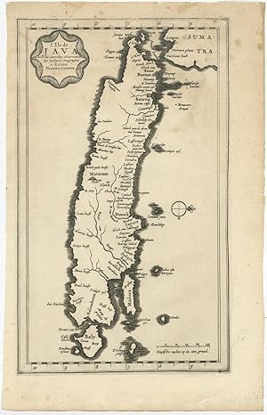
Published by P. van der Aa 1725
- Map
Seller: Bartele Gallery - The Netherlands, Langweer, FRL, NetherlandsBartele Gallery - The Netherlands
Contact seller5-star sellerCondition: Used - Good
US$ 291.51
US$ 19.68 shippingShips from Netherlands to U.S.A.Quantity: 1 available
No Binding. Condition: Good. Antique map titled 'L'Ile de Java'. (The island of Java.) This map shows the Indonesian island of Java. With compass rose and scale. General age-related toning, some staining and small tears. Please study image carefully. Overall size: 19.5 x 21 cm. Image size: 16 x 27 cm.
 More images
- First Edition
- Art Print
Seller: Hammelburger Antiquariat, Hammelburg, , GermanyHammelburger Antiquariat
Contact seller5-star sellerCondition: Used - Fine
US$ 2,861.36
US$ 34.73 shippingShips from Germany to U.S.A.Quantity: 1 available
Kein Einband. Condition: Sehr gut. 1. Auflage. Carte de L ´Ile de Java. Chatelain, anno 1719, very good condition and authentic map Carte de l'Ile de Java: Partie Occidentale, Partie Orientale, Dressee tout Nouvellement Sur Les Memoires Les Plus Exacts; By: Henri Abraham Chatelain Date: 1719 (published) Amsterdam Dimensions: 47x…92 cm. (sheet). This is an authentic antique map of the island of Java showing portion of Sumatra and Bali. The map was produced for Chatelain's VII volume world atlas out of Amsterdam in 1719 This is without question, the most elaborate, and accurate large format map of the Island of Java and its coastline of the early 18th century. The city and port of Batavia (Jakarta) can be found in the northwest portion of the island as well as in a large insert in the lower left portion of the map. Above the map are two drapery style title banners written by Gueudeville, that present the history of the island as well as the presence of the Dutch. Additional text on either side of the map refer to various cities and villages of Java Condition: Map is in very good condition, with wide margins and a strong impression.
 More images
- Map
Seller: ThePrintsCollector, Zeeland, , NetherlandsThePrintsCollector
Contact seller5-star sellerCondition: Used - Good
US$ 297.47
US$ 20.84 shippingShips from Netherlands to U.S.A.Quantity: 1 available
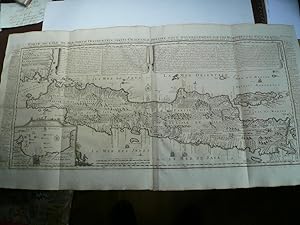
Condition: Good. Antique Map, titled: 'Carte de l'isle de Java.' - Map of Java. From an edition of "L'Hydrographie Francoise Recueil des Cartes Generales et Particulieres qui ont ete Faites pour le Service des Vaisseaux du Roy." by Bellin. Map of Java. Engraving on laid paper. Watermark: Textband Auvergne Made by 'P. Croisey' an…d published by 'Jacques Nicolas Bellin'. P. Croisey worked around 1770-1800 in Versailles as engraver. Jacques-Nicolas Bellin (1703-1772) was one of the most important cartographers of the 18th century. With a career spanning some 50 years, Bellin is best understood as geographe de cabinet and transitional mapmaker spanning the gap between 18th and early 19th century cartographic styles. Good, given age. Small margins, , with the vertical folds as published, small abrasion in upper rightcorner. General age-related toning and/or occasional minor defects from handling. Please study scan carefully. The overall size is ca. 45.6 x 25 cm. The image size is ca. 43.5 x 21.5 cm. The overall size is ca. 18 x 9.8 inch. The image size is ca. 17.1 x 8.5 inch. Storage location: E47-03.

Seller: Bartele Gallery - The Netherlands, Langweer, FRL, NetherlandsBartele Gallery - The Netherlands
Contact seller5-star sellerCondition: Used
US$ 417.28
US$ 19.68 shippingShips from Netherlands to U.S.A.Quantity: 1 available
Antique map titled 'La Rade de Bantam'. A small early 18th century black and white map of Banten Bay (or Bantam Bay), located near the northwest coast of Java. Published by P. van der Aa, circa 1720. Artists and Engravers: Apprenticed at the age of 9, Van der Aa began his career at Leiden in 1683 as a Latin trade publisher, publ…ishing classical texts pertaining to medicine and science. Later on, he became an engraver and publisher of atlases and maps in Leiden. His publications include an 'Atlas Nouveau' completed in about 1710, and the famous La Galerie Agréable du Monde ? one of the most impressive geographical books printed in 66 volumes in limited edition. It contains around 3000 plates, and cover the topography and people of Europe, Asia, Africa and America. Condition: Good, general age-related toning and/or occasional minor defects from handling. Water stain at the bottom left. Please study scan carefully. Date: c.1720 Overall size: 19.4 x 30.3 cm Image size: 16 x 16.2 cm We sell original antique maps to collectors, historians, educators and interior decorators all over the world. Our collection includes a wide range of authentic antique maps from the 16th to the 20th centuries. Buying and collecting antique maps is a tradition that goes back hundreds of years. Antique maps have proved a richly rewarding investment over the past decade, thanks to a growing appreciation of their unique historical appeal. Today the decorative qualities of antique maps are widely recognized by interior designers who appreciate their beauty and design flexibility. Depending on the individual map, presentation, and context, a rare or antique map can be modern, traditional, abstract, figurative, serious or whimsical. We offer a wide range of authentic antique maps for any budget.

Seller: Bartele Gallery - The Netherlands, Langweer, FRL, NetherlandsBartele Gallery - The Netherlands
Contact seller5-star sellerCondition: Used
US$ 470.93
US$ 19.68 shippingShips from Netherlands to U.S.A.Quantity: 1 available
Antique map titled 'Map: 'L'Ile de Java'. (The island of Java.) This map shows the Indonesian island of Java. With compass rose and scale. This plate originates from the very scarse: 'La galerie agreable du monde'. Tome premier des Indes Orientales.', published by P. van der Aa, Leyden, c. 1725. This famous work was published in… 66 parts and is the biggest print / map book ever published. Van der Aa incorporated plates by other publishers such as Blaeu, Visscher, de Wit, meurs, Halma, Mortier, Allard in this work and often added broad decorative borders. Probably the costliest and complete universal geographic work ever produced. It is said that only 100 copies were printed. Ref: Koeman Aa9; Phillips 2780 note. Artists and Engravers: Pieter Van Der Aa (Leiden 1659-1733) was a Dutch publisher best known for preparing maps and atlases. The Galerie Agreable contains plates and maps by the best Dutch engravers: Luiken, Goeree, Mulder, Stoopendaal, ao. Condition: Good. General age related toning and occasional light staining from handling. Paper edge uncut and thus irregular. Original middle fold as issued. Please study image carefully. Date: 1725 Overall size: 49 x 38 cm. Image size: 16 x 27 cm. We sell original antique maps to collectors, historians, educators and interior decorators all over the world. Our collection includes a wide range of authentic antique maps from the 16th to the 20th centuries. Buying and collecting antique maps is a tradition that goes back hundreds of years. Antique maps have proved a richly rewarding investment over the past decade, thanks to a growing appreciation of their unique historical appeal. Today the decorative qualities of antique maps are widely recognized by interior designers who appreciate their beauty and design flexibility. Depending on the individual map, presentation, and context, a rare or antique map can be modern, traditional, abstract, figurative, serious or whimsical. We offer a wide range of authentic antique maps for any budget.

Seller: Bartele Gallery - The Netherlands, Langweer, FRL, NetherlandsBartele Gallery - The Netherlands
Contact seller5-star sellerCondition: Used
US$ 536.51
US$ 19.68 shippingShips from Netherlands to U.S.A.Quantity: 1 available
Antique map titled 'Idee de l'Isle de Java.' Well engraved and attractive chart of the island shows all principal harbors and coastal details, plus rivers, mountains and volcanoes, bays, the settlements and villages, and political districts. Locates Batavia (Jakarta). Map also includes Madura Island, most of Bali, the Sunda Stra…it with the Krakatau Islands, and the southeastern tip of Sumatra. The island is divided into provinces and the kingdoms of Bantam, Tsieribon (Cirebon) and Jacatra (Jakatra). Decorated with a very fancy rococo-style title cartouche and rhumb lines with fleur-de-lys. Source unknown, to be determined. Artists and Engravers: Made by 'Jacques Nicolas Bellin' after an anonymous artist. Jacques Nicolas Bellin (1703 - 1772) was a French hydrographer, geographer, and member of the French intellectual group called the philosophes. Bellin was born in Paris. He was hydrographer of France's hydrographic office, member of the Academie de Marine and of the Royal Society of London. Over a 50 year career, he produced a large number of maps of particular interest to the Ministere de la Marine. Artist: Made by 'Jacques Nicolas Bellin' after an anonymous artist. Jacques Nicolas Bellin (1703 - 1772) was a French hydrographer, geographer, and member of the French intellectual group called the philosophes. Bellin was born in Paris. He was hydrographer of France's hydrographic office, member of the Academie de Marine and of the Royal Society of London. Over a 50 year career, he produced a large number of maps of particular interest to the Ministere de la Marine. Condition: Good, given age. Paper slightly toned. Some faint stianing in the lower edge of the image. The margins with some faint foxing. Irregular bottom edge as issued. Original folds as issued. General age-related toning and/or occasional minor defects from handling. Please study image carefully. Date: c.1760 Overall size: 50 x 24.5 cm. Image size: 43 x 20.4 cm. We sell original antique maps to collectors, historians, educators and interior decorators all over the world. Our collection includes a wide range of authentic antique maps from the 16th to the 20th centuries. Buying and collecting antique maps is a tradition that goes back hundreds of years. Antique maps have proved a richly rewarding investment over the past decade, thanks to a growing appreciation of their unique historical appeal. Today the decorative qualities of antique maps are widely recognized by interior designers who appreciate their beauty and design flexibility. Depending on the individual map, presentation, and context, a rare or antique map can be modern, traditional, abstract, figurative, serious or whimsical. We offer a wide range of authentic antique maps for any budget.

Seller: Bartele Gallery - The Netherlands, Langweer, FRL, NetherlandsBartele Gallery - The Netherlands
Contact seller5-star sellerCondition: Used
US$ 536.51
US$ 19.68 shippingShips from Netherlands to U.S.A.Quantity: 1 available
Antique map titled 'Nouvelle Carte de l'Isle de Java (.) - Nieuwe Kaart van het Eiland Java (.)'. Chart of the island of Java, depicting soundings around the coast, all principal harbors, rivers and elevations, bays and points, settlements and provinces. Included are Madura, Bali, Sunda Strait and the southeastern tip of Sumatra…. By J.N. Bellin from 'Atlas portatif' by Francois Raynal. Made by J. van Schley after J.N. Bellin. Jacques Nicolas Bellin (1703 - 1772) was a French hydrographer, geographer, and member of the French intellectual group called the philosophes.

Seller: Bartele Gallery - The Netherlands, Langweer, FRL, NetherlandsBartele Gallery - The Netherlands
Contact seller5-star sellerCondition: Used
US$ 536.51
US$ 19.68 shippingShips from Netherlands to U.S.A.Quantity: 1 available
Antique map titled 'Nouvelle Carte de l'Isle de Java'. Chart of the island of Java, depicting soundings around the coast, all principal harbors, rivers and elevations, bays and points, settlements and provinces. Included are Madura, Bali, Sunda Strait and the southeastern tip of Sumatra. This map originates from 'Histoire genera…le des voyages, ou nouvelle collection de toutes les relations de voyages (.)'. Artist: Jacques Nicolas Bellin (1703 - 1772) was a French hydrographer, geographer, and member of the French intellectual group called the philosophes. Condition: Good, Restored tear to the upper edge and to the lower right corner. Stain in the lower middle, please study image carefully. Date: c.1760 Overall size: 48 x 25.5 cm. Image size: 43 x 20 cm. We sell original antique maps to collectors, historians, educators and interior decorators all over the world. Our collection includes a wide range of authentic antique maps from the 16th to the 20th centuries. Buying and collecting antique maps is a tradition that goes back hundreds of years. Antique maps have proved a richly rewarding investment over the past decade, thanks to a growing appreciation of their unique historical appeal. Today the decorative qualities of antique maps are widely recognized by interior designers who appreciate their beauty and design flexibility. Depending on the individual map, presentation, and context, a rare or antique map can be modern, traditional, abstract, figurative, serious or whimsical. We offer a wide range of authentic antique maps for any budget.

Seller: Bartele Gallery - The Netherlands, Langweer, FRL, NetherlandsBartele Gallery - The Netherlands
Contact seller5-star sellerCondition: Used
US$ 3,874.76
US$ 19.68 shippingShips from Netherlands to U.S.A.Quantity: 1 available
Antique map titled 'Insulae Iavae cum parte insularum Boreno Sumatrae (.)'. Beautiful map of the island of Java and part of Borneo, Bali, Madura and Sumatra. With decorative cartouches featuring natives and Chinese merchants flanking the title and Neptune and mermaids surrounding the scale of miles. Artists and Engravers: Jan Ja…nssonius (also known as Johann or Jan Jansson or Janszoon) (1588-1664) was a renowned geographer and publisher of the seventeenth century, when the Dutch dominated map publishing in Europe. Born in Arnhem, Jan was first exposed to the trade via his father, who was also a bookseller and publisher. In 1612, Jan married the daughter of Jodocus Hondius, who was also a prominent mapmaker and seller. Jonssonius first maps date from 1616. Artist: Jan Janssonius (also known as Johann or Jan Jansson or Janszoon) (1588-1664) was a renowned geographer and publisher of the seventeenth century, when the Dutch dominated map publishing in Europe. Born in Arnhem, Jan was first exposed to the trade via his father, who was also a bookseller and publisher. In 1612, Jan married the daughter of Jodocus Hondius, who was also a prominent mapmaker and seller. Jonssonius? first maps date from 1616. Condition: Good, general age-related toning. Original/contemporary hand coloring. Small repair on folding line, blank verso. Please study image carefully. Date: c.1650 Overall size: 61.5 x 54 cm. Image size: 51 x 41 cm.

Seller: Bartele Gallery - The Netherlands, Langweer, FRL, NetherlandsBartele Gallery - The Netherlands
Contact seller5-star sellerCondition: Used
US$ 774.95
US$ 19.68 shippingShips from Netherlands to U.S.A.Quantity: 1 available
Title: "Kaart van 't Eyland Groot Java: Antique Map of Java, Indonesia" Description: This antique map, titled "Kaart van 't Eyland Groot Java," offers a rare and valuable depiction of the island of Java in Indonesia. It is a historical treasure that provides insights into the geography, topography, and features of Java during th…e 18th century. The map is derived from "Reistogt naar en door Oostindiën," a work by W. Schouten, published in 1780. It serves as a significant historical document, showcasing the cartographic knowledge of Java at that time and contributing to our understanding of the island's past.
 More images
Seller: Bartele Gallery - The Netherlands, Langweer, FRL, NetherlandsBartele Gallery - The Netherlands
Contact seller5-star sellerCondition: Used
US$ 810.72
US$ 19.68 shippingShips from Netherlands to U.S.A.Quantity: 1 available
This rare map shows the Indonesian island of Java. With compass rose and scale. From: Nouvel Atlas, très exact et fort commode pour toutes sortes de personnes, Contenant Les Principales cartes géographiques. Leiden, P. Van der Aa, n.d. (1713).


