
Order Total (1 Item Items):
Shipping Destination:

Antique Map Java Bali by Dornseiffen (1 results)
Skip to main search results
Search filters
Product Type
- All Product Types
- Books (No further results match this refinement)
- Magazines & Periodicals (No further results match this refinement)
- Comics (No further results match this refinement)
- Sheet Music (No further results match this refinement)
- Art, Prints & Posters (No further results match this refinement)
- Photographs (No further results match this refinement)
- Maps (1)
- Manuscripts & Paper Collectibles (No further results match this refinement)
Condition Learn more
- New (No further results match this refinement)
- As New, Fine or Near Fine (No further results match this refinement)
- Very Good or Good (No further results match this refinement)
- Fair or Poor (1)
- As Described (No further results match this refinement)
Binding
- All Bindings
- Hardcover (No further results match this refinement)
- Softcover (No further results match this refinement)
Collectible Attributes
- First Edition (No further results match this refinement)
- Signed (No further results match this refinement)
- Dust Jacket (No further results match this refinement)
- Seller-Supplied Images (1)
- Not Print on Demand (1)
Language (1)
Price
- Any Price
- Under US$ 25 (No further results match this refinement)
- US$ 25 to US$ 50 (No further results match this refinement)
- Over US$ 50
Free Shipping
- Free Shipping to U.S.A. (No further results match this refinement)
Seller Location
Seller Rating
-
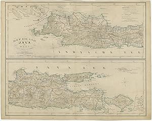
Antique Map of Java and Bali by Dornseiffen (1878)
Publication Date: 1878
Seller: Bartele Gallery - The Netherlands, Langweer, FRL, Netherlands
Seller rating 5 out of 5 stars

Map
No Binding. Condition: Fair. Antique map titled 'Het Eiland Java en Bali'. Map of Java and Bali. This map originates from 'Atlas van Nederland en zijne overzeesche bezittingen' by I. Dornseiffen. Original folding line, strong toning. Some wear and small defects, blank verso. Please study image carefully. Overall size: 43 x 34 cm. Image size: 40 x 32.5 cm.