

Order Total (1 Item Items):
Shipping Destination:

Antique Map World Eastern Hemisphere (5 results)
Skip to main search results
Search filters
Product Type
- All Product Types
- Books (2)
- Magazines & Periodicals (No further results match this refinement)
- Comics (No further results match this refinement)
- Sheet Music (No further results match this refinement)
- Art, Prints & Posters (No further results match this refinement)
- Photographs (No further results match this refinement)
- Maps (3)
- Manuscripts & Paper Collectibles (No further results match this refinement)
Condition Learn more
- New (No further results match this refinement)
- As New, Fine or Near Fine (1)
- Very Good or Good (1)
- Fair or Poor (No further results match this refinement)
- As Described (3)
Binding
- All Bindings
- Hardcover (No further results match this refinement)
- Softcover (No further results match this refinement)
Collectible Attributes
- First Edition (1)
- Signed (1)
- Dust Jacket (No further results match this refinement)
- Seller-Supplied Images (4)
- Not Print on Demand (5)
Language (1)
Price
- Any Price
- Under US$ 25 (No further results match this refinement)
- US$ 25 to US$ 50
- Over US$ 50
Free Shipping
- Free Shipping to U.S.A. (No further results match this refinement)
Seller Location
Seller Rating
-

c1860 Large Colour Antique Map EASTERN HEMISPHERE World (MA/2)
Seller: Antique Paper Company, ASHFORD, KENT, United Kingdom
Seller rating 2 out of 5 stars

Listing Template 2018 Home About Us View Feedback Contact Us c1860 Large Colour Antique Map EASTERN HEMISPHERE World (MA/2)Click image to enlargeDescriptionc1860Large original colour maptitled:EASTERNHEMISPHERE A fine Celestial Map showing the Constellations Boreal AustralProvenanceTaken from 'A MODERN ATLAS containing THIRTY MAPS with Indexes' published by The Society for Promoting Christian KnowledgeGood conditionwith central fold as issued. There might be some occasional tone spots, which for a map of this age, would be normal.Size of mapapprox 35cm x 41cm (13.7in x 16in) including margins.Shipping View Our Categories Decorative Prints World Wide Maps Scotland Maps Architecture Design England Maps Royalty About UsWe specialise in selling all items that can be considered to be Antique Paper. * PRINTS * MAPS * HISTORICAL DOCUMENTS * POSTAL HISTORY * BOOKS * POSTERS * STAMPS * POSTCARDS * EPHEMERA And anything else that is considered Antique and made of Paper. ALL OF OUR ITEMS ARE ORIGINAL ANTIQUES - NOT MODERN COPIES. We are also very keen buyers of anything similar and especially after better collections, original archives, whole libraries and better single items and have and#163;250,000 in cash funds at anyone time to buy the right items. Contact UsIf you have any questions then please do not hesitate to contact us through the eBay messaging system. Feedback We will always help you to have a 100% positive happy buying experience. Contact us if you are unhappy about any aspect of your purchase from us. We only want five star feedback from you so buy with confidence.
-
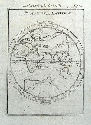
Antique Map WORLD, EASTERN HEMISPHERE, Latitude lines, Mallet original 1719
Seller: Lindisfarne Prints, Shrewsbury, SHROP, United Kingdom
Seller rating 5 out of 5 stars

Map
US$ 38.20
US$ 14.57 shipping
Ships from United Kingdom to U.S.A.Quantity: 1 available
Add to basketAntique Map PARALLELES DE LATITUDEbyAlain Manesson Mallet.Published Frankfurt 1719 in "Beschreibung des ganzen Welt Kreises.", a German translation of Mallet's "Description de L'Univers."A copper engraved antique world map of the Eastern Hemisphere with its lines of latitude.Fine condition, on hand laid paper, blank verso. Approx. 5.5" x 4" (140mm x 110mm) printed area only with good margins beyond. ALLAIN MANESSON MALLET (1630 - 1706)Mallet started out as a soldier serving King Louis XIV as an inspector of fortifications but later was appointed as mathematics teacher at the King's court. He is chiefly remembered however for his publications of "Description de L'Univers" (1683) in 5 volumes, and "Les Travaux de Mars ou l'Art de la Guerre" (1684) in 3 volumes. A GENUINE ANTIQUE MAP GUARANTEED OVER 290 YEARS OLD FROM LINDISFARNE PRINTST9871.
-
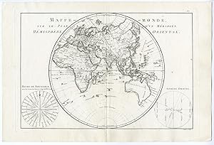
Antique Print-WORLD MAP-MAPPE MONDE-EASTERN HEMISPHERE-AFRICA-ASIA-Bonne-1787
Publication Date: 1787
Seller: Pictura Prints, Art & Books, Overasselt, Netherlands
Seller rating 5 out of 5 stars
No binding. Condition: Very Good. Rigobert Bonne (illustrator). 'Mappe-Monde sur Le Plan D'Un Meridien Hemisphere Orientale ().'Copperplate engraving/etching on hand laid (verge) paper. Sheet size: 41,7 x 28 cm. (16,4 x 11 inch). Image size: 34,2 x 23,2 cm. (13,5 x 9,1 inch).Atlas encyclopedique, contenant la geographie ancienne et quelques cartes () by Rigobert Bonne and Nicolas Desmarest, published in France 1787.Made by an anonymous engraver after 'Rigobert Bonne'. Condition: Very good, given age. A few minor crinkles. Original middle fold as issued. General age-related toning and/or occasional minor defects from handling. Please study scan carefully.Keywords: WORLD MAP-MAPPE MONDE-EASTERN HEMISPHERE-AFRICA-ASIAPCOM-A8-03.
-
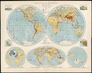
Map : 'Westliche und Ostliche Halbkugel'. (World Map, Western and Eastern Hemisphere). This plate also shows sea depth, mountain height, hemispheres oriented toward showing the largest land mass and water mass, as well as two views of St. Paul and two the Vesuvius. Colour lithograph on a vellin type paper. Description: This large antique map is taken from; 'Andrees Allgemeiner Handatlas in 126 Haupt-Und 139 Nebenkarten', Bielefeld; Leipzig: Velhagen & Klasing 1899. Andrees Allgemeiner Handatlas was a major cartographic work published in several German and foreign editions 1881-1937. It was named after Richard Andree (1835-1912) and published by Velhagen & Klasing, Bielefeld and Leipzig, Germany. By using chromolithography, rather than copper plate engraving, but reproducing the maps from zinc plates that were etched in relief (just like letterpress printing), V & K was able to offer detailed maps at a much lower price than competing works, such as the 7th and 8th editions of Stielers Handatlas.Artists and Engravers: Richard Andree (1835 - 1912) was, like his father Karl Andree, a German geographer noted for devoting himself especially to ethnography. His main work, however, is his Allgemeiner Handatlas (Leipzig, first edition 1881, final edition 1937), one of the most comprehensive world atlases of all times. The early editions of the Times Atlas of the World (1895-1900) are based on this atlas, as was Cassell's Universal Atlas. Condition: Excellent; General age related toning and slight soiling; Please study scan carefully. Storage location: B36-02 The overall size is ca. 22 x 17.3 inch. The image size is ca. 20.5 x 15.9 inch. The overall size is ca. 56 x 44 cm. The image size is ca. 52 x 40.5 cm.
-

1850 - RARE Antique Map of "EASTERN HEMISPHERE" World TALLIS FULL COLOUR (36)
Seller: Antique Paper Company, ASHFORD, KENT, United Kingdom
Seller rating 2 out of 5 stars
Map Signed
US$ 272.89
US$ 7.95 shipping
Ships from United Kingdom to U.S.A.Quantity: 1 available
Add to basketNo Binding. Condition: Fine. No Jacket. 1850 - RARE Antique Map of "EASTERN HEMISPHERE" World TALLIS FULL COLOUR (36) For more info please ask seller a question. Royal Mail 2nd Class - £0.00 Royal Mail 2nd Class Signed For - £4.50 Standard Int'l age - £4.00 Royal Mail International Signed - £8.00 No PICK UP OPTIONSorry, our items are NOT available for pick-up.PAYING VIA PAYPALWe accept on our all our items so you can shop with confidence.Simple choose the option when proceeding through the checkout.


