
Order Total (1 Item Items):
Shipping Destination:

Asia by Arrowsmith Aaron (6 results)
Skip to main search results
Search filters
Product Type
- All Product Types
- Books (4)
- Magazines & Periodicals (No further results match this refinement)
- Comics (No further results match this refinement)
- Sheet Music (No further results match this refinement)
- Art, Prints & Posters (1)
- Photographs (No further results match this refinement)
- Maps (1)
- Manuscripts & Paper Collectibles (No further results match this refinement)
Condition Learn more
- New (No further results match this refinement)
- As New, Fine or Near Fine (1)
- Very Good or Good (No further results match this refinement)
- Fair or Poor (No further results match this refinement)
- As Described (5)
Binding
- All Bindings
- Hardcover (2)
- Softcover (No further results match this refinement)
Collectible Attributes
- First Edition (1)
- Signed (2)
- Dust Jacket (No further results match this refinement)
- Seller-Supplied Images (4)
- Not Print on Demand (6)
Language (2)
Price
- Any Price
- Under US$ 25 (No further results match this refinement)
- US$ 25 to US$ 50 (No further results match this refinement)
- Over US$ 50
Free Shipping
Seller Location
Seller Rating
-

ASIA
Language: English
Published by Longman, Hurst, Rees & Orme, Paternoster Row, London, 1806
Seller: THOMAS RARE BOOKS, Yaxley, SUFFOLK, United Kingdom
Seller rating 4 out of 5 stars

Map First Edition
US$ 339.41
US$ 20.17 shipping
Ships from United Kingdom to U.S.A.Quantity: 1 available
Add to basketNo Binding. Condition: Fine. 1st Edition. Original early 19th century map MAP OF ASIA BY AARON ARROWSMITH.A FINE, CLEAN AND DARK IMPRESSION. Original folding plate, printed on heavy paper A scarce example and in fine un-coloured original condition. An occasional light foxing mark. 41x27cms. Double-page folding map. Engraved by Edw. Jones.A LOVELY COPY. Imprint date May 6th 1806.
-
Asia.
Published by Aaron Arrowsmith,, London,, 1801
Seller: Antiquariaat FORUM BV, Houten, Netherlands
Seller rating 5 out of 5 stars

US$ 8,963.64
US$ 29.01 shipping
Ships from Netherlands to U.S.A.Quantity: 1 available
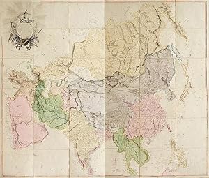
Add to basketLarge, highly detailed wall map of Asia and the Arabian peninsula, giving a view from the Ural Mountains and Black Sea, across to China, Japan and the Philippines, including India and Ceylon, but stopping just above Singapore and Indonesia. Arrowsmith was "easily the foremost cartographer of his time" (Tooley) and presents here a very accurate map of the continent, which shows significant improvement over previous ones. The map is dedicated to James Rennell, surveyor general of the East India Company and the father of Indian cartography.With an owner's inscription of the army officer and colonial governor General Robert Brownrigg on the title-label mounted on the slipcase. Brownrigg (1759-1833) was appointed Governor of Ceylon in 1815 and brought the last part of Sri Lanka, the Kingdom of Kandy, under British rule. Only a few minor spots, but otherwise in very good condition.l David Rumsey 6907.001; not in Al Ankary; Al-Qasimi; for Arrowsmith: Tooley, p. 24; for Brownrigg: G.S. Powell, "Brownrigg, Sir Robert, first baronet (1759-1833)" in ODNB online. Contemporary slipcase, covered with marbled paper and a manuscript title-label on front. Engraved wall map, hand coloured in outline, on 4 sheets joined as 2 (measuring 124 x 147 cm in total) on a scale of ca. 1:6,490,880, with an elaborately decorated cartouche at the head left, a dedication below ("To major James Rennell, Esqr. F.R.S. &c. &c.") and the name of the engraver at the foot right (George Allen). Mounted on cloth and divided into 32 sections.
-

Asia. To Major James Rennell, Esqr. F.R.S. &c. &c. This Map is Inscribed, by His much Obliged Humble Servant. January 1st 1801. A. Arrowsmith.
Published by London, A. Arrowsmith No. 24 Rathbone Place, 1801., 1801
Seller: Antiquariat INLIBRIS Gilhofer Nfg. GmbH, Vienna, A, Austria
Association Member: ILAB PADA VDA VDAO
Seller rating 5 out of 5 stars
Signed
Engraved map, fine original hand-colour, edged with blue silk, housed in original marbled paper chemise and slipcase, with red morocco label, lettered in gilt. 1470 x 1290 mm. The most accurate map of Asia published at the beginning of the 19th century. It shows significant advancement compared with other maps of the period, incorporating the work of surveyors like James Rennell, to whom the map was dedicated. Rennell was surveyor-general of the East India Company's dominions in Bengal, and the information published in his "Bengal Atlas" in 1779 appears here. Arrowsmith also included remarkable topographical detail such as mountain ranges in regions as remote as Tibet. Remarkably the region on the shore of the Arabian Gulf is already labelled as "Bani Yas" territory. Arrowsmith has marked the track of Lap�rouse's voyage in the Indian Ocean and Far East. - Aaron Arrowsmith (1750-1823) was the finest cartographer of his generation. Although he received little formal education, it is believed that he was provided with some mathematical instruction by William Emerson, an author of several books on the application of mathematics to the area of cartography. Around 1770, Arrowsmith moved to London to seek employment. It is believed that he worked for William Faden before joining John Cary Sr. in the early 1780s. There he provided the measurements for John Cary's early publication detailing the roads from London to Falmouth, his first signed work. Arrowsmith set up on his own in 1790 and over the next thirty years produced some of the most beautiful and elegant maps of the era. - In perfect condition. - Not in Al Ankary or Al-Qasimi. Cf. Sweet 238 (1811 edition only).
-

Central Asia.
Published by (John Conrad & Co.) (1804)., (Philadelphia)., 1804
Seller: Asia Bookroom ANZAAB/ILAB, Canberra, ACT, Australia
Association Member: ANZAAB ILAB
Seller rating 5 out of 5 stars
Engraved map, 24.3 x 39.5 cms; 26.9 x 44.2 cms (sheet), relief indicated with hachures, original folds, numbered in ink "27" in top corner (faded), minor edge-toning otherwise in very good condition. An uncommon Arrowsmith map of Central Asia "From Du Halde, D'Anville, Islenieff &c. &c. but Imperfect and inaccurate authorities", published before the Great Game. The map extends from the Caspian Sea in the west, to Manchura in the east; and from "Kolhyvan" (Western Siberia) in the north to Tibet in the South. It charts a region then largely mysterious to Western cartographers and a frontier for geopolitical ambitions: a caption north of the Kailash range reads "Unknown parts of Greater Tibet".
-
Asia
Published by London: Aaron Arrowsmith, 1 January 1801., 1801
Seller: Arader Galleries - AraderNYC, New York, NY, U.S.A.
Seller rating 5 out of 5 stars
Fine folding engraved wall map mounted on cartographic linen (50 x 58 4/8 inches) in 24 sections by George Allen, with fine hand-colouring in outline, with the title in a large cartouche top left (some marginal waterstain along the top edge, a bit browned). A fine wall map dedicated to Major James Rennell (1724-1830) and showing the track of the "Lion" in 1793, commanded by Sir Erasmus Gower, the ship which took Lord Macartney embassy to China in 1793 and 1794. It includes all of Asia from the Arabian Gulf in the West, to the Philippines in the southeast, the Arctic circle in the north and the Ceylon in the south. Rennell regarded as "the Father of Indian Surveying" (Gole "Early Maps of India") charted the currents through the India Ocean and around Africa, and later surveyed the Indian interior. He recognized Europe's growing fascination with India: "As almost every particular relating to Hindoostan is become an object of popular curiosity, it can hardly be deemed superfluous to lay before the public an improved system of its geography" (Rennell Preface to "Memoir of a Map of Hindoostan.", 1785). He was appointed at age 24 as surveyor of the British East India Company's dominions in Bengal. In 1765, Rennell began surveying India. By this time, the British East India Company had maintained its foothold on the region for over one hundred years, but it was still another century before Queen Victoria would set her eyes eastward, and Rennell's explorations and accounts helped to fill that gap in time. Rennell combined data from British Army columns with Ain-e-Akbari (1598), a translation of Islamic geography of the empire which helped him acquire information about old divisions (he therefore subdivided the country according to the Mughal provinces of 'subas'). Aaron Arrowsmith's reputation for drafting accurate, detailed charts earned him the titles of Hydrographer to the King of England and Geographer to the Prince of Wales, extremely important distinctions during an era when Britain ruled the waves. One of the first great British cartographers of North America, Arrowsmith introduced a new standard of excellence in mapmaking in the late 18th century and almost single-handedly made London the center for the cartographic trade. Arrowsmith built his great success on this ability to attract both commercial and general viewers through his combination of visual and scientific appeal. The most influential and respected map publisher of the late 18th and early 19th centuries, Arrowsmith issued maps that were the result of careful synthesis rather than systematic, scientific inquiry. His role in cartographic production was to gather the best available information from a wide variety of sources, weigh the relative merits of conflicting data, and compile the most accurate depiction possible of an area. Arrowsmith accomplished this synthesis better than any other commercial mapmaker of his day and, as a result, his maps were the most sought after and highly prized on three continents.
-
Asia. To Major James Rennell, Esqr. F.R.S. &c. &c. This Map is Inscribed, by His much Obliged Humble Servant. January 1st 1801. A. Arrowsmith.
Published by London, G. Allen for A. Arrowsmith, 1801., 1801
Seller: Antiquariat INLIBRIS Gilhofer Nfg. GmbH, Vienna, A, Austria
Association Member: ILAB PADA VDA VDAO
Seller rating 5 out of 5 stars
Art / Print / Poster Signed
Engraved map in 36 segments on canvas, folded. Fine original hand-colour. Ca. 1450 x 1230 mm. Earliest edition of this wall map, the most accurate map of Asia published at the beginning of the 19th century. It shows significant advancement compared with other maps of the period, incorporating the work of surveyors like James Rennell, to whom the map was dedicated. Rennell was surveyor-general of the East India Company's dominions in Bengal, and the information published in his "Bengal Atlas" in 1779 appears here. Arrowsmith also included remarkable topographical detail such as mountain ranges in regions as remote as Tibet. Remarkably, the region on the shore of the Arabian Gulf is already labelled as "Bani Yas" territory. Arrowsmith has marked the track of Lap�rouse's voyage in the Indian Ocean and Far East. - Aaron Arrowsmith (1750-1823) was the finest cartographer of his generation. Although he received little formal education, it is believed that he was provided with some mathematical instruction by William Emerson, an author of several books on the application of mathematics to the area of cartography. Around 1770, Arrowsmith moved to London to seek employment. It is believed that he worked for William Faden before joining John Cary Sr. in the early 1780s. There he provided the measurements for John Cary's early publication detailing the roads from London to Falmouth, his first signed work. Arrowsmith set up on his own in 1790 and over the next thirty years produced some of the most beautiful and elegant maps of the era. "This highly detailed wall map of Asia is probably one of the most accurate maps of the continent before the completion of the Ordnance Survey maps of 1820" (Sweet). - Slightly soiled and browned, but well preserved. - Not in Al Ankary or Al-Qasimi. Cf. Sweet 238 (1811 edition only).

