Bath Boothbay Harbor (3 results)

Seller: Art Source International Inc., Boulder, CO, U.S.A.Art Source International Inc.
Contact seller5-star sellerThis coastal survey, produced in 1948, shows Boothbay Harbor to Bath, including Kennebec River. It was made by the United States Coast and Geodetic Survey. These surveys provide notes on important characteristics, including depth readings, and names of harbors, rivers, and coastal towns. The charts illustrate areas that have lik…ely undergone significant changes due to modifications and recessions of coastal lands, making them fascinating to anyone interested in local geography and history. This map measures 44.25 inches by 33.25 inches.

Published by Published by the United States Coast and Geodetic Survey, Washington D.C. 1919
- Map
Seller: Donald A. Heald Rare Books (ABAA), New York, NY, U.S.A.Donald A. Heald Rare Books (ABAA)
Contact seller5-star sellerLarge folding nautical chart, printed on heavy paper stock. Uncolored. A rare original coastal survey of Bath and Boothbay Harbor including Bath, Georgetown, Boothbay, and Westport and Southport Islands. Established by President Thomas Jefferson in 1807 as the Survey of the Coast, the U.S. Coast and Geodetic Survey was the Unite…d States' first civilian scientific agency. This agency has followed its mission to survey the U.S. coastline, create nautical charts of the coast, and help increase maritime safety since its founding, and has often played fascinating roles in significant chapters of U.S. history. It served in all theaters of the Civil War in the service of the Union Army and Navy, pioneered acoustic exploration in the wake of the sinking of the Titanic, and during WWI it worked to detect enemy submarines. In addition, this agency worked to survey and produce detailed maps and renderings of the U.S. coast. These nautical survey maps (commonly referred to as "T-sheets") provide fascinating insights into the history of the United States coastline, which has and will continue to shift. These maps are the most important data source for understanding the physical and ecological characteristics of the U.S. shoreline. The present map is a highly detailed and accurate sea chart of Bath and Boothbay Harbor, and an important historical view of developing Maine.
Published by Published by the United States Coast and Geodetic Survey, Washington D.C. 1922
- Map
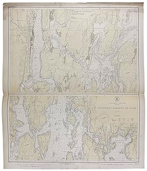
Seller: Donald A. Heald Rare Books (ABAA), New York, NY, U.S.A.Donald A. Heald Rare Books (ABAA)
Contact seller5-star sellerLarge folding nautical chart, printed on heavy paper stock. Colored. Bisected into two maps. A rare original coastal survey of Maine including Boothbay Harbor, Bath, and Georgetown. Established by President Thomas Jefferson in 1807 as the Survey of the Coast, the U.S. Coast and Geodetic Survey was the United States' first civili…an scientific agency. This agency has followed its mission to survey the U.S. coastline, create nautical charts of the coast, and help increase maritime safety since its founding, and has often played fascinating roles in significant chapters of U.S. history. It served in all theaters of the Civil War in the service of the Union Army and Navy, pioneered acoustic exploration in the wake of the sinking of the Titanic, and during WWI it worked to detect enemy submarines. In addition, this agency worked to survey and produce detailed maps and renderings of the U.S. coast. These nautical survey maps (commonly referred to as "T-sheets") provide fascinating insights into the history of the United States coastline, which has and will continue to shift. These maps are the most important data source for understanding the physical and ecological characteristics of the U.S. shoreline. The present map is a highly detailed and accurate sea chart of coastal Maine from Boothbay Harbor to Bath, and an important historical view of the developing state.


