Carte ´ile Java Chatelain Anno by Chatelain (1 results)
 More images
- First Edition
- Art Print
Seller: Hammelburger Antiquariat, Hammelburg, , GermanyHammelburger Antiquariat
Contact seller5-star sellerCondition: Used - Fine
US$ 2,844.43
US$ 34.52 shippingShips from Germany to U.S.A.Quantity: 1 available
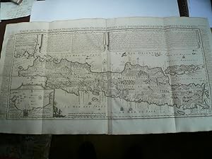
Kein Einband. Condition: Sehr gut. 1. Auflage. Carte de L ´Ile de Java. Chatelain, anno 1719, very good condition and authentic map Carte de l'Ile de Java: Partie Occidentale, Partie Orientale, Dressee tout Nouvellement Sur Les Memoires Les Plus Exacts; By: Henri Abraham Chatelain Date: 1719 (published) Amsterdam Dimensions: 47x…92 cm. (sheet). This is an authentic antique map of the island of Java showing portion of Sumatra and Bali. The map was produced for Chatelain's VII volume world atlas out of Amsterdam in 1719 This is without question, the most elaborate, and accurate large format map of the Island of Java and its coastline of the early 18th century. The city and port of Batavia (Jakarta) can be found in the northwest portion of the island as well as in a large insert in the lower left portion of the map. Above the map are two drapery style title banners written by Gueudeville, that present the history of the island as well as the presence of the Dutch. Additional text on either side of the map refer to various cities and villages of Java Condition: Map is in very good condition, with wide margins and a strong impression.
