Order Total (1 Item Items):
Shipping Destination:

Chart South Part Sumatra Straits by Laurie Whittle (2 results)
Feedback
Skip to main search results
Search filters
Product Type
- All Product Types
- Books (2)
- Magazines & Periodicals (No further results match this refinement)
- Comics (No further results match this refinement)
- Sheet Music (No further results match this refinement)
- Art, Prints & Posters (No further results match this refinement)
- Photographs (No further results match this refinement)
- Maps (No further results match this refinement)
- Manuscripts & Paper Collectibles (No further results match this refinement)
Condition Learn more
- New (No further results match this refinement)
- As New, Fine or Near Fine (No further results match this refinement)
- Very Good or Good (2)
- Fair or Poor (No further results match this refinement)
- As Described (No further results match this refinement)
Binding
- All Bindings
- Hardcover (No further results match this refinement)
- Softcover (No further results match this refinement)
Collectible Attributes
- First Edition (No further results match this refinement)
- Signed (No further results match this refinement)
- Dust Jacket (No further results match this refinement)
- Seller-Supplied Images (2)
- Not Print on Demand (2)
Language (1)
Price
- Any Price
- Under US$ 25 (No further results match this refinement)
- US$ 25 to US$ 50 (No further results match this refinement)
- Over US$ 50
Free Shipping
- Free Shipping to U.S.A. (No further results match this refinement)
Seller Location
Seller Rating
-

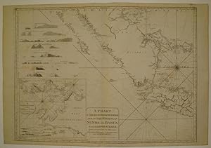
A Chart of the South Part of Sumatra and of the Straits of Sunda and Banca. With Gaspar Straits. Corrected and Improved from the Observations of Capt. Josh. Huddart, Capt. John Hall and Capt. Henry Smedley
Published by Laurie and Whittle, London, 1794
Seller: Antipodean Books, Maps & Prints, ABAA, Garrison, NY, U.S.A.
Association Member: ABAA ANZAAB ESA ILAB
Seller rating 5 out of 5 stars

Maps. Condition: Very good condition. Scarce sea atlas by cartographers Laurie and Whittle, of southern Sumatra (cut off at the equator), and western Java. Batavia, the former official name of present day Jakarta, is labeled, inset of "A Particular Chart of the Straits of Sunda". Copper engraving, Impression 33 1/2" wide x 25 1/4", black on cream background with latitude and longitudinal marks around perimeter, coastal profiles of Padang, Pulo Pesang, Broken Point, Pulo Tellores, Mount Monopin, Seven Islands, Pulo Taya, Pulo Linging. Some faint fox spotting lower left, otherwise clean, bright, vgc.
-
A Chart of the South Part of Sumatra and of the Straits of Sunda and Banca with Gaspar Straits.
Published by Laurie & Whittle, London, 1799
Seller: Argosy Book Store, ABAA, ILAB, New York, NY, U.S.A.
Seller rating 5 out of 5 stars
unbound. Condition: very good. Sea chart. Uncolored copper plate engraving. Image measures 24" x 32.5". Stunning chart of the southern tip of Sumatra, with the Strait of Sunda and part of Java and the Java Sea. Includes rhumb lines, depths, shoals, a compass rose and an inset map: "A Particular Chart of the Straits of Sunda." The coast lines are further illustrated with with many topographical cross sections. Published in "The East-India Pilot, or Oriental Navigator, on One Hundred and Eighteen Plates: Containing a Complete Collection of Charts and Plans, &c." (plate 94). Maps are based on the 1745 French "Neptune Oriental" by Jean Baptiste Nicolas Denis d'Apres de Mannevillette. The later English editions include additions by Captain Joseph Huddart, Captain John Hall and Captain Henry Smedley.