Cheape Ward (4 results)

Published by London 1720
- First Edition
- Art Print
Seller: Trillium Antique Prints & Rare Books, Franklin, TN, U.S.A.Trillium Antique Prints & Rare Books
Contact seller2-star sellerCondition: Used - Fine
US$ 100.00
US$ 10.00 shippingShips within U.S.A.Quantity: 1 available
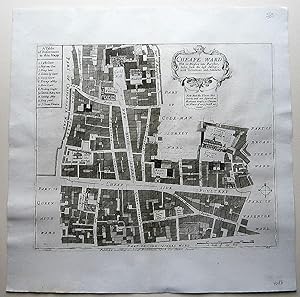
Condition: Fine. 1st Edition. This historic engraving is from John Stow's "A Survey of the Cities of London and Westminster. Corrected, Improved, and Very Much Enlarged. to the Present Time" completed by John Strype. This is the fifth edition of the work published by Churchill [and others] in 1720 in London. It is the first Stry…pe edition, the best and most desriable. John Stow originally published the work in 1698 and John Strype improved upon and enlarged the work. --- The work featured exact maps of the city, surrounding suburbs, and wards. It also included engravings of some important buildings and estates. Stow's work was the "starting point of all inquiry into the subject of Elizabethan London." Of the ward maps, Hyde noted "Many of these maps are excellent. Their clarity and accuracy fulfill the requirements of the student of London history." (Hyde) Johannes Kip was responsible for many of the building or monument engravings. --- "The reader of A Survey travels with Stow through each of the city's wards and the adjoining city of Westminster, learns about the wall, bridges, gates, and parish churches . . . [Stow] also records the negative aspects of urban growth, in the shape of unsightly sprawl, filth, the destruction of ancient monuments, and above all poverty. His book approaches the thoroughness of an encyclopaedia . . . It is noteworthy that while Camden's Britannia was written in Latin for the educated à lite, Stow's Survey was composed in the language of his fellow countrymen." --- "Throughout his life at Low Leyton, Strype crossed the River Lea into London each week to meet and converse with his antiquarian friends and to call on his contacts in the book trade. . . . The Survey had been repeatedly revised and enlarged in order to keep up with the changing aspect of the post-fire city, now much expanded and altered in its religion and other ways. . . . Although Strype had arranged most of the work by 1707, and the engravings had been prepared, it was set aside after the publication of Edward Hatton's New View of London in 1708, which seemed to cover much the same ground and was considerably smaller and cheaper. . . . Finally, once the defects of Hatton's book were acknowledged another agreement in November 1716 led to the Survey's publication at the end of 1720. . . . The print run was probably more than 500 copies . . . To quote Merritt, By this stage the Survey has a multiple personality, switching with little warning from nostalgic Elizabethan antiquary [Stow] . . . to diligent post-Restoration recorder of events [Strype] and back again." (Merritt, 87) --- The work is in very good to excellent condition. There may be a few minor imperfections to be expected with age. Please review the image carefully for condition and contact us with any questions. --- Paper Size ~ 17 3/8" by 15 1/2".

Published by London 1720
- Map
Seller: Robert Frew Ltd. ABA ILAB, London, , United KingdomRobert Frew Ltd. ABA ILAB
Contact seller5-star sellerCondition: Used
US$ 103.57
US$ 13.41 shippingShips from United Kingdom to U.S.A.Quantity: 1 available
Original engraved plan (30 x 37 cm.). (Adams, 25, 34).
Published by W.Innys and J.Richardson [et al], London 1754
- Map
Seller: Angelika C. J. Friebe Ltd. - MapWoman, Dorking, United KingdomAngelika C. J. Friebe Ltd. - MapWoman
Contact seller5-star sellerCondition: Used - Very good
US$ 483.31
US$ 26.81 shippingShips from United Kingdom to U.S.A.Quantity: 1 available
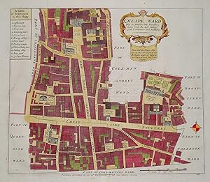
No Binding. Condition: Very Good. copper engraved map; overall 42 x 45 cm, plate 30 x 36 cm. folds as issued; some foxing, staining and off-set; some discolouration in centrefold ; paper imperfections ; o/w vg cond. First published in 1720, Strype s re-issue appears as a much larger and expanded, 2 volume publication of Stow s S…urvey which, originally, was published in 1598. Strype added to Stow s original account numerous information about customs, institutions, monuments, charities, events like the Great Fire of London, the guilds and wards as well as detailed descriptions of the parish churches, and the city itself, and used a lot of Stow s original 17th century material that was excluded by Stow himself. Ward map with Table of Reference from Strype s A Survey of the Cities of Westminster, and the Borough of Southwark. Containing The Original, Antiquity, Increase, present State and Government of those cities. Written in the Year 1698.[corrected to 1598 in Vol II] Corrected, Improved, and very much Enlarged, in the year 1720, By John Strype. . There are 25 ancient wards in the City of London which are still used for local elections. John Strype was the son of Huguenot immigrants from Brabant who was educated at St. Paul s School and later at Jesus College,Cambridge. After completing his studies in 1669, he became curate of Theydon Bois and afterwards in Leyton.Though never being inducted, he was licensed by the Bishop of London to preach and expound the word of God, and to perform the office of priest and curate while it was vacant . In 1711, he obtained the sinecure of.
 More images
- Map
Seller: Lindisfarne Prints, Shrewsbury, SHROP, United KingdomLindisfarne Prints
Contact seller5-star sellerCondition: Used
US$ 103.57
US$ 14.75 shippingShips from United Kingdom to U.S.A.Quantity: 1 available
Antique MapCHEAPE WARDWith its Division into Parishes by John Stow Published London 1754 in "Stow's Survey of London" by John StrypeA highly detailed plan of central London including Cheapside, Poultry, New Kings Street, Queens Street, Grocer's Hall, Guildhall, St. Mary Bow Church, Honey Lane market etc.Enhanced with later hand… colouring. Dated in the plate.The level of detail can be appreciated from the close up image provided.All the streets and important places are named with a further 12 places identified in a numbered key. Stow originally published his survey in 1598 with a second edition in 1603. John Strype saw a great need for an updated survey and subseqently published a much expanded and amended version in 1722 with a further edition in 1744. It remains a fascinating record of 18th century London. Fine, clean condition other than minor age related blemishes, free of repairs or restoration, central fold line as issued, blank verso. Approx. 13.5" x 12" (350mm x 300mm) printed area only with wide margins beyond.NDPH1122.


