Chicago by Augustus Mitchell (15 results)

Published by Mitchell, S. Augustus, Philadelphia 1867
- Map
Seller: mediumraremaps.com, Franklin, U.S.A.mediumraremaps.com
Contact seller5-star sellerCondition: Used - Very good
US$ 65.00
US$ 6.00 shippingShips within U.S.A.Quantity: 1 available
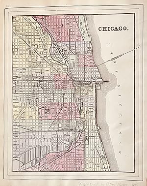
Add to basket10 3/4 x 13 1/4 inches. Condition: Very Good. This is a superbly colored map of Illinois and its counties designated with the use of two colors and no color for the third designator. The inset plan of Chicago is also designated with color by ward. Taken from an 1867 edition of Mitchells General Atlas it would look excellent fram…ed an on the wall. Mitchell, S. A. (illustrator).
 More images
Published by Philadelphia : S. Augustus Mitchell, 1866. 1866
Seller: Schilb Antiquarian, Columbia, U.S.A.Schilb Antiquarian
Contact seller5-star sellerCondition: Used - Very good
US$ 99.00
Free ShippingShips within U.S.A.Quantity: 1 available
Add to basketNo Binding. Condition: Very Good. 1866 Color Steel Engraved Map of ILLINOIS Missouri River CHICAGO City Map Samuel Augustus Mitchell (1790 1868) was an American geographer. Map maker: Samuel Augustus Mitchell Title: "County map of the state of Illinois" Atlas Title: Mitchell's New General Atlas containing maps of the various cou…ntries of the world, plans of cities, etc., embraced in fifty-eight quarto maps, forming a series of ninety-two maps and plans, together with valuable statistical tables. Published: Philadelphia : S. Augustus Mitchell, 1866. FREE SHIPPING WORLDWIDE Wear: wear as seen in photos Publisher: Philadelphia : S. Augustus Mitchell, 1866. Size: ~17.5in X 14in (44.5cm x 35.5cm) Photos available upon request.

Published by Mitchell, S Augustus, Philadelphia 1867
- Map
Seller: mediumraremaps.com, Franklin, U.S.A.mediumraremaps.com
Contact seller5-star seller11 1/2 x 13 3/4 inches. Single page lithograph hand-colored at the time of publication. This is Mitchell's presentation prior to the Chicago Fire. It is divided into political units by appropriate coloring. It is a very good example with nice margins. coloring. Very good with nice margins for framing.

Published by Mitchell, S. Augustus, Philadelphia 1872
- Map
Seller: mediumraremaps.com, Franklin, U.S.A.mediumraremaps.com
Contact seller5-star sellerCondition: Used - Very good
US$ 135.00
US$ 6.00 shippingShips within U.S.A.Quantity: 1 available
Add to basket11 x 13 3/4 Inches. Condition: Very good. This map was created in the year after the October, 1871 Chicago Fire. The burnt district has been laid out within the hand coloring scheme. As such, it represents an easy appearance of the delineation within the production of an atlas. The Mitchell firm was prolific in its cartographic…output. This period-current presentation was a cartographic scoop with its inclusion in the 1872 atlas.

Published by Mitchell, S. Augustus, Philadelphia 1880
- Map
Seller: mediumraremaps.com, Franklin, U.S.A.mediumraremaps.com
Contact seller5-star seller21 3/4 x 14 3/8 inches. Double page map of Chicago colored when published. This map is an extension of Mitchell's information set that is not only visual but is textual as well. As such the streets are keyed into the map providing a useful tool for navigating the built landscape. This would make it a good road map on how to get…from here to there. Very good having a small marginal chip in the upper side not going into the map.

Seller: Art Source International Inc., Boulder, U.S.A.Art Source International Inc.
Contact seller5-star sellerIn 1860 S. Augustus Mitchell Jr. took over his father's map publishing business and in that year he started publishing Mitchell's New General Atlas. Editions of the new general were issued annually until 1887. Mitchell Jr. continued publishing this atlas until 1879. The editions from 1880 to 1887 were published by Wm. M. Bradley…. This map published in 1865 is a wonderful example of Mitchell's map-making prowess with beautiful original hand-coloring. This map measures 10.5 inches by 13.5 inches.

Published by Philadelphia, 1867
- Art Print
Seller: libreria antiquaria perini Sas di Perini, Verona, Italylibreria antiquaria perini Sas di Perini
Contact seller5-star sellerCondition: Used
US$ 154.45
US$ 46.14 shippingShips from Italy to U.S.A.Quantity: 1 available
Add to basketIncisione in acciaio, dipinta d'epoca a tutto campo, 284x345. Pianta topografica della citt? di Chicago inquadrata entro bordura decorativa con vitigno intrecciato.Bell'esemplare ben conservato, minimi lievi tracce di sporco superficiale ai margini e numero della carta "68" manoscritto coevo all'ang. sup. destro. Nr.cat: 137.
 More images
Published by Hilton & Hughes, New York 1885
- Map
Seller: mediumraremaps.com, Franklin, U.S.A.mediumraremaps.com
Contact seller5-star sellerCondition: Used - Very good
US$ 250.00
US$ 6.00 shippingShips within U.S.A.Quantity: 1 available
Add to basket20 x 14 1/4 inches. Condition: Very good condition. This double page map was executed with printed color. Illinois occupies a double page. On the verso of one is a map of St. Louis. The verso of the other page carries a map of Chicago delicately framed within two external neat lines. This is a very nice cartographic presentation… from a rare atlas.
Published by Hilton & Hughes in Atlas of the World, New York 1885
- Map
Seller: mediumraremaps.com, Franklin, U.S.A.mediumraremaps.com
Contact seller5-star seller1885 Edition. This map was printed in color and came from an atlas most likely produced by the Bradley Firm that was successor to the Mitchell firm. Further it was apparently published for the firm of Hilton and Hughes whom are listed on the title page as publisher. The map of Chicago and also of St. Louis are pure Mitchell. The… map of Illinois is a superb rarecord of the contemporary railroad networks. The map of Illinois is difficult to find in the marketplace and is from a rare late 19th century atlas. Very Good condition with several small tears repaired with archival mending tape Chicago, 10 3/4 x 13 1/2 : St. Louis, 10 3/4 x 14 1/2; Illinois, 14 x 20, with inset of Chicago and Vicinity of 8 1/2 x 6.

Seller: Art Source International Inc., Boulder, U.S.A.Art Source International Inc.
Contact seller5-star sellerThis map was made by S. Augustus Mitchell for "Mitchells New General Atlas" published in 1887. The well maintained maps in this atlas feature Mitchell's characteristic pastel coloring and abundant details of geographical features. The plan of Chicago is illustrated on this map. Details include the names of streets, important bui…ldings, rivers, lakes, parks and railroads. Sections of the city are distinguished by color. These 1887 maps offer a fascinating perspective of areas that have since undergone significant growth and change, in addition to their value as great examples of Mitchell's work. This map measures 11 inches by 13.5 inches.

Seller: Art Source International Inc., Boulder, U.S.A.Art Source International Inc.
Contact seller5-star sellerThis map of Chicago, Illinois was made by S. Augustus Mitchell for "Mitchells New General Atlas" published in 1888, by WM. M. Bradley & Co. The well maintained maps in this atlas feature Mitchell's characteristic pastel coloring and abundant details of geographical features. Details include the names of streets, railroads, trans…portation routes, lakes, rivers, and various points of interest. These 1888 maps offer a fascinating perspective of areas that have since undergone significant growth and change, in addition to their value as great examples of Mitchell's work. This map measures 11 inches by 13.5 inches.

Seller: Art Source International Inc., Boulder, U.S.A.Art Source International Inc.
Contact seller5-star sellerThis map was made by S. Augustus Mitchell for "Mitchell's New General Atlas" published in 1884, by WM. M. Bradley & Co. The well maintained maps in this atlas feature Mitchell's characteristic pastel coloring and abundant geographical features. Details include the names of streets, rail roads, depots, canals, parks, rivers and c…reeks. City sections are distinguished by color. These 1884 maps offer a fascinating perspective of areas that have since undergone significant growth and change, in addition to their value as great examples of Mitchell's work. This map measures 11 inches by 13.5 inches.

Seller: Art Source International Inc., Boulder, U.S.A.Art Source International Inc.
Contact seller5-star sellerThis map was produced by S. Augustus Mitchell in 1875 for his New General Atlas. This map shows Mitchells traditional grape vine border, characteristic pastel coloring and abundant details of geographical features. Counties are distinguished by different colors. Wagon trails and major routes of transport are also shown. These 18…75 maps offer a fascinating perspective of areas that have since undergone significant growth and change, in addition to their value as great examples of Mitchell's work. This map measures 11 inches by 14 inches.

Seller: Art Source International Inc., Boulder, U.S.A.Art Source International Inc.
Contact seller5-star sellerExtremely rare and hard to find, this map of Chicago was made by S. Augustus Mitchell in 1872. Pastel coloring differentiates city sections, and city streets, parks, and railroads, depots are illustrated. A distinctive ivy style border completes this map beautifully. This map measures 11 inches by 13.5 inches.

Seller: Art Source International Inc., Boulder, U.S.A.Art Source International Inc.
Contact seller5-star sellerThis hand colored map was made for "Mitchells New General Atlas" published in 1868 by S. Augustus Mitchell, Jr. The plan of Chicago is illustrated on this map. Sections of the city are distinguished by color. Other details include the names of streets and important buildings, railroads, major roads, and rivers. The pastel colori…ng in this atlas is very beautiful and more muted than typical. This map measures 11.25 inches by 13.5 inches.


