
Order Total (1 Item Items):
Shipping Destination:

Clinton by Beers Frederick (1 results)
Skip to main search results
Search filters
Product Type
- All Product Types
- Books (1)
- Magazines & Periodicals (No further results match this refinement)
- Comics (No further results match this refinement)
- Sheet Music (No further results match this refinement)
- Art, Prints & Posters (No further results match this refinement)
- Photographs (No further results match this refinement)
- Maps (No further results match this refinement)
- Manuscripts & Paper Collectibles (No further results match this refinement)
Condition Learn more
- New (No further results match this refinement)
- As New, Fine or Near Fine (No further results match this refinement)
- Very Good or Good (No further results match this refinement)
- Fair or Poor (No further results match this refinement)
- As Described (1)
Binding
- All Bindings
- Hardcover (No further results match this refinement)
- Softcover (No further results match this refinement)
Collectible Attributes
- First Edition (No further results match this refinement)
- Signed (No further results match this refinement)
- Dust Jacket (No further results match this refinement)
- Seller-Supplied Images (1)
- Not Print on Demand (1)
Language (1)
Price
- Any Price
- Under US$ 25 (No further results match this refinement)
- US$ 25 to US$ 50 (No further results match this refinement)
- Over US$ 50
Free Shipping
- Free Shipping to U.S.A. (No further results match this refinement)
Seller Location
Seller Rating
-
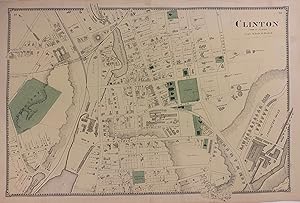
Clinton
Published by Beers, Comstock, & Cline, New York, 1870
Seller: Argosy Book Store, ABAA, ILAB, New York, NY, U.S.A.
Seller rating 5 out of 5 stars

unbound. Map. Engraving with original hand coloring. Image measures 14 1/4" x 22 1/2" This 1870 map by Frederick W. Beers shows the town of Clinton, Massachusetts. This map was published in Beers' Atlas of Worcester County, Massachusetts (1870). Frederick W. Beers (flourished 1858-1929) came from a family of surveyors, cartographers and publishers originally from Newtown, Connecticut. F.W. Beers continued the work of his father James Botsford Beers and was known for his county survey maps of New York, Ohio, Pennsylvania, Michigan, Connecticut and Vermont.