Order Total (1 Item Items):
Shipping Destination:

Cuba by Augustus Mitchell (16 results)
Skip to main search results
Search filters
Product Type
- All Product Types
- Books (14)
- Magazines & Periodicals (No further results match this refinement)
- Comics (No further results match this refinement)
- Sheet Music (No further results match this refinement)
- Art, Prints & Posters (1)
- Photographs (No further results match this refinement)
- Maps (1)
- Manuscripts & Paper Collectibles (No further results match this refinement)
Condition Learn more
- New (No further results match this refinement)
- As New, Fine or Near Fine (1)
- Very Good or Good (3)
- Fair or Poor (1)
- As Described (11)
Binding
- All Bindings
- Hardcover (No further results match this refinement)
- Softcover (1)
Collectible Attributes
- First Edition (2)
- Signed (No further results match this refinement)
- Dust Jacket (No further results match this refinement)
- Seller-Supplied Images (15)
- Not Print on Demand (16)
Language (1)
Price
- Any Price
- Under US$ 25 (No further results match this refinement)
- US$ 25 to US$ 50
- Over US$ 50
Free Shipping
Seller Location
Seller Rating
-

MAP: West Indies, including the Island of Cuba (#XXI.from Mitchell's Modern Atlas)
Published by Buer, Philadelphia, PA, 1886
Seller: Dorley House Books, Inc., Hagerstown, MD, U.S.A.
Seller rating 4 out of 5 stars

Art / Print / Poster First Edition
Unbound. Condition: Very Good. Handcolored/copperplate (illustrator). 1st. ' colored map; South America on reverse. suitable for framing Size: 9" x 12".
-
1866 HUGE Color Steel Engraved Map of CENTRAL AMERICA Mexico Cuba West Indies
Published by Philadelphia : S. Augustus Mitchell, 1866., 1866
No Binding. Condition: Very Good. 1866 HUGE Color Steel Engraved Map of CENTRAL AMERICA Mexico Cuba West Indies Samuel Augustus Mitchell (1790 1868) was an American geographer. Map maker: Samuel Augustus Mitchell Title: "Map of Mexico, Central America, and the West Indies." Atlas Title: Mitchell's New General Atlas containing maps of the various countries of the world, plans of cities, etc., embraced in fifty-eight quarto maps, forming a series of ninety-two maps and plans, together with valuable statistical tables. Published: Philadelphia : S. Augustus Mitchell, 1866. Note: double page map FREE SHIPPING WORLDWIDE Wear: wear as seen in photos Publisher: Philadelphia : S. Augustus Mitchell, 1866. Size: ~34in X 14in (85cm x 35.5cm) Photos available upon request.
-
Color Steel Engraved Map of NORTH AMERICA United States Canada Mexico Cuba
Published by Philadelphia : S. Augustus Mitchell, 1866., 1866
No Binding. Condition: Very Good. 1866 Color Steel Engraved Map of NORTH AMERICA United States Canada Mexico Cuba Samuel Augustus Mitchell (1790 1868) was an American geographer. Map maker: Samuel Augustus Mitchell Title: "Map of North America showing its political divisions, and recent discoveries in the polar regions." Atlas Title: Mitchell's New General Atlas containing maps of the various countries of the world, plans of cities, etc., embraced in fifty-eight quarto maps, forming a series of ninety-two maps and plans, together with valuable statistical tables. Published: Philadelphia : S. Augustus Mitchell, 1866. FREE SHIPPING WORLDWIDE Wear: wear as seen in photos Publisher: Philadelphia : S. Augusts Mitchell, 1866. Size: ~17.5in X 14in (44.5cm x 35.5cm) Photos available upon request.
-
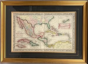
Map of Mexico, Central America, and the West Indies. (with four insets) 49. Map of the Island of Cuba. 50. Map of the Island of Jamaica. 51. Map of the Bermuda Islands. 52. Map of the Panama Railroad.
Published by S.A. Mitchell Jr., Philadelphia, 1865
Steel Engraving, hand colored. Condition: Near Fine. Single leaf, with center fold. 34cm x 54cm measurements to outer edge of decorative border. Steel engraving with elaborate hand coloring. Professionally framed, with frame measurements of 54cm x 73cm, gilt frame, glazed with optically correct glass. A very handsome package; Mitchell's "Map of Mexico, Central America, and the West Indies." professionally framed. Map condition is near fine with brilliant color, and only superficial wear. Source: Mitchell's New General Atlas, Philadelphia: Published By S. Augustus Mitchell, Jr. No. 31 South Sixth Street. 1865. Second state. [pg #48 in upper right corner].
-

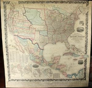
Mitchell's new national map exhibiting the United States : with the North American British provinces, Sandwich Islands, Mexico and Central America, together with Cuba and other West India Islands
Published by Philadelphia : S. Augustus Mitchell, 1856
Seller: Sequitur Books, Boonsboro, MD, U.S.A.
Association Member: IOBA
Seller rating 5 out of 5 stars

Map First Edition
Map. Condition: Fair. First Edition. [Large Wall-Map] 170 x 175 cm. (63 x 64 inches.) Canvas mounted on round wooden dowels. Hand colored lithographic map, showing antebellum United States, Mexico, Central America, Southern Canada, and the Caribbean. Borders of American States, Canadian Provinces, Mexican States and national borders colored. Inset maps of: the World in Mercator and Globular views; a map of the Sandwich Islands, Hawaii. Additional vignettes of Columbus's ship discovering America, Landing of the Pilgrims in 1622, and the Flying Cloud clipper ship, the American steam ship crossing the Atlantic. Foliate border. Varnish slight;y toned, yellowed. Some fray to top left outer margin. Creases at center. Scale [ca. 1:2,500,000].; (W 125 - W 62/N 55 - N 06). Prime meridians: Greenwich and Washington (D.C.). Includes distant, census, and statistical tables and explanation of road symbols. "This edition has new topographical detail in New Mexico from the Pacific Railway Surveys, as well as a redrawn California border. "Dakotah" is shown for the first time. With black top and bottom sticks. Full color by state or territory. " Refs: Wheat, TMW 896; Phillips, America p 906; Rumsey 2292. This is an oversized map, requiring additional costs for shipping.
-
Mitchell's new national map, exhibiting the United States, with the North American British Provinces, Sandwich Islands, Mexico, and Central America. Together with Cuba and the West India Islands
Published by S. Augustus Mitchell, Philadelphia, 1859
Seller: Rulon-Miller Books (ABAA / ILAB), St. Paul, MN, U.S.A.
Association Member: ABAA ILAB RMABA
Seller rating 5 out of 5 stars
Large hand-colored wall map on rods, approx. 64" square, with 4 engraved vignettes, 3 inset maps (2 of the world, and 1 of the Sandwich Islands), all within an elaborate floral border; some infill along the margins, slight loss in the population tables at the bottom, and several cracks in the paper, the whole neatly and professionally backed with linen; overall appearance is certainly very good or better, with the usual small defects. America as it was on the eve of the Civil War. Unusual features of this map include the Shoshone Territory (what is now mostly Idaho), Colona (now part of Colorado), the unusually large Nebraska, the horizontal Utah and New Mexico, and the unusually small Dakotas. Phillips, Maps of America, lists only the 1856 edition. OCLC records examples from 1856, 1857 (both on conjoined sheets), 1858, 1860 and 1861, but not this.
-

Map of Mexico, Central America and the West Indies with Inset Maps of Bermuda, Panama, Cuba, and Jamaica
Publication Date: 1866
Seller: Art Source International Inc., Boulder, CO, U.S.A.
Seller rating 5 out of 5 stars
The Mitchell company was one of the first to try out the new technique of engraving on steel plates experimenting with steel almost 20 years before the rest of the publishing industry. He was printing with steel in the early 1830s; the general switch to steel was approximately 1850. During the early years of the company, Mitchell published mainly maps and travel guides. In 1860, Mitchell started producing "Mitchell's New General Atlas",and Mitchell Sr. retired and turned the business over to his son of the same name. The New General Atlas was published until 1893. Today Mitchell maps are sought after for their fine engraving, bright coloring, and attention to detail. They are some of the finest maps produced during this time period. This map produced in 1866, has Mitchell's unique floral border, and beautiful hand coloring. This map details Mexico, Central America and the West Indies with Inset Maps of Bermuda, Panama, Cuba, and Jamaica. Counties, cities, towns, lakes, rivers, mountains, and transportation routes are noted. Each map was printed on thick paper with vibrant hand color. This map measure 21 inches by 13 inches.
-

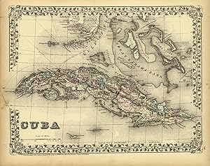
Cuba
Publication Date: 1875
Seller: Art Source International Inc., Boulder, CO, U.S.A.
Seller rating 5 out of 5 stars
This map was produced by S. Augustus Mitchell in 1875 for his New General Atlas. This map shows Mitchells traditional grape vine border, characteristic pastel coloring and abundant details of geographical features. Counties are distinguished by different colors. Wagon trails and major routes of transport are also shown. These 1875 maps offer a fascinating perspective of areas that have since undergone significant growth and change, in addition to their value as great examples of Mitchell's work. This map measure 14.5 inches by 10.5 inches.
-

Cuba
Publication Date: 1887
Seller: Art Source International Inc., Boulder, CO, U.S.A.
Seller rating 5 out of 5 stars
This map was made by S. Augustus Mitchell for "Mitchell's New General Atlas" published in 1887. The well maintained maps in this atlas feature Mitchell's characteristic pastel coloring and abundant details of geographical features. Cuba is illustrated on this page. Details include the names of regions, important towns, rivers, lakes, and mountain ranges. Regions are distinguished by color. These 1887 maps offer a fascinating perspective of areas that have since undergone significant growth and change, in addition to their value as great examples of Mitchell's work. This map has water stains in the margin that do not affect the map. This map measure 14.5 inches by 11 inches.
-

Cuba
Publication Date: 1878
Seller: Art Source International Inc., Boulder, CO, U.S.A.
Seller rating 5 out of 5 stars
This map was produced by Augustus Mitchell in 1878 for his New General Atlas. Highlights of this map are Mitchells traditional grapevine border, characteristic pastel coloring and abundant details of geographical features. The map of Cuba and surrounding islands are illustrated on this map with Eastern and Western divisions clearly defined. Countries are distinguished by color. This 1878 map offers a fascinating perspective of areas that have since undergone significant growth and change, in addition to the value as great examples of Mitchell's classic mapmaking style. This map measure 14 inches by 11 inches.
-

Cuba
Publication Date: 1885
Seller: Art Source International Inc., Boulder, CO, U.S.A.
Seller rating 5 out of 5 stars
This map was made by S. Augustus Mitchell for "Mitchells New General Atlas" published in 1885, by WM. M. Bradley & Co. The well maintained maps in this atlas feature Mitchell's characteristic pastel coloring and abundant details of geographical features. Details include the names of continents, countries, oceans, seas, mountain ranges and explorers routes. These 1885 maps offer a fascinating perspective of areas that have since undergone significant growth and change, in addition to their value as great examples of Mitchell's work. This map measure 12 inches by 9 inches.
-

Cuba
Publication Date: 1881
Seller: Art Source International Inc., Boulder, CO, U.S.A.
Seller rating 5 out of 5 stars
This map came from Mitchells New General Atlas, 1881. This map shows major railroads, water bodies, and towns. Decorative ivy border, and nice colorful detail. Would look nice framed!' This map measure 14 inches by 11.5 inches.
-

Cuba
Publication Date: 1884
Seller: Art Source International Inc., Boulder, CO, U.S.A.
Seller rating 5 out of 5 stars
This map was made by S. Augustus Mitchell for "Mitchells New General Atlas" published in 1884, by WM. M. Bradley & Co. The well maintained maps in this atlas feature Mitchell's characteristic pastel coloring and abundant geographical features. Details include the names of countries, regions, cities, towns, transportation routes, rivers, lakes, and mountain ranges. Regions are distinguished by color. These 1884 maps offer a fascinating perspective of areas that have since undergone significant growth and change, in addition to their value as great examples of Mitchell's work. This map measure 12 inches by 10 inches.
-

Cuba
Publication Date: 1879
Seller: Art Source International Inc., Boulder, CO, U.S.A.
Seller rating 5 out of 5 stars
This map of Cuba was produced by Augustus Mitchell in 1879 for his New General Atlas. Highlights of this map are Mitchells traditional grapevine border, characteristic pastel coloring and abundant details of geographical features. This 1879 map offers a fascinating perspective of areas that have since undergone significant growth and change, in addition to the value as great examples of Mitchell's classic map-making style. This map measure 14.5 inches by 11.25 inches.
-

Cuba
Publication Date: 1877
Seller: Art Source International Inc., Boulder, CO, U.S.A.
Seller rating 5 out of 5 stars
This hand colored map of Cuba was made by S. Augustus Mitchell in 1877 for "Mitchells New General Atlas". ' This map measure 14.5 inches by 11 inches.
-
Cuba
Publication Date: 1872
Seller: Art Source International Inc., Boulder, CO, U.S.A.
Seller rating 5 out of 5 stars
S. Augustus Mitchell Jr. made this hand colored map for "Mitchells New General Atlas" in 1872. A beautiful map of Cuba . Regions, cities, rivers, mountain ranges and neighboring islands are illustrated. Surrounding the beautifully hand colored map is the characteristic ' inch ivy style border. This map measure 14 inches by 10.5 inches.