Denmark by Map (43 results)

- Hardcover
- First Edition
Seller: Dorley House Books, Inc., Hagerstown, MD, U.S.A.Dorley House Books, Inc.
Contact seller4-star sellerCondition: Used - Near fine
US$ 25.00
US$ 8.65 shippingShips within U.S.A.Quantity: 1 available
Hardcover. Condition: Near Fine. Dust Jacket Condition: Very Good. 1st. 1st printing; dj w/unclipped price; 256 clean, unmarked pages/index; owner's label. 16 pages b/w Illus + Map (illustrator).
Published by George Philip and Son Limited., London. 1940
- Map
Seller: N. G. Lawrie Books, sheffield, , United KingdomN. G. Lawrie Books
Contact seller5-star sellerCondition: Used - Very good
US$ 6.90
US$ 12.74 shippingShips from United Kingdom to U.S.A.Quantity: 1 available
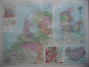
Condition: Very Good. Colour Map from Philips' International Atlas. Measures approx 15 3/4 x 20 1/2 inches. Centre fold. With inset maps of Amsterdam, North Sea Canal & Copenhagen.

Published by The Times., London. 1922
- Map
Seller: N. G. Lawrie Books, sheffield, , United KingdomN. G. Lawrie Books
Contact seller5-star sellerCondition: Used - Very good
US$ 6.90
US$ 12.74 shippingShips from United Kingdom to U.S.A.Quantity: 1 available
Condition: Very Good+. Colour map measures approx 22 3/4 x 17 3/4 inches (including margins). Centre fold. From The Times Survey Atlas of The World. Prepared under the direction of J. G. Bartholomew.
Published by Rand McNally & Co, Chicago, IL 1887
- Softcover
- First Edition
Seller: Dorley House Books, Inc., Hagerstown, MD, U.S.A.Dorley House Books, Inc.
Contact seller4-star sellerCondition: Used - Very good
US$ 20.00
US$ 8.65 shippingShips within U.S.A.Quantity: 1 available
Unbound. Condition: Very Good. 1st. very nice w/decorative border; inset shows Iceland .suitable for framing Size: 16.5" x 11.25". Handcolored Map (illustrator).

Language: English
Published by Thames & Hudson, London 1962
- Hardcover
Seller: Dorley House Books, Inc., Hagerstown, MD, U.S.A.Dorley House Books, Inc.
Contact seller4-star sellerCondition: Used - Very good
US$ 35.00
US$ 8.65 shippingShips within U.S.A.Quantity: 1 available
Hardcover. Condition: Very Good. Dust Jacket Condition: Very Good. 2nd printing; dj w/lite wear only, unclipped price, in mylar; green-bluee c w/gilt decorations/titles, 212 clean, unmarked pages/index. 73 Photos, 15 Line Drawings, 1 Map (illustrator).

Language: English
Published by Rand McNally & Company, Chicago, IL 1895
- Map
Seller: Dorley House Books, Inc., Hagerstown, MD, U.S.A.Dorley House Books, Inc.
Contact seller4-star sellerCondition: Used - Very good
US$ 30.00
US$ 8.65 shippingShips within U.S.A.Quantity: 1 available
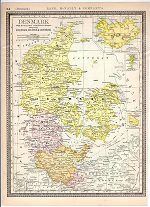
No Binding. Condition: Very Good. colored 11' X 14' map of Denmark w/inbsets if Ucekabd abd the Faroe Island. colored map (illustrator).

Baedeker's Scandinavia Denmark Norway Sweden Finland : The Complete Illustrated Travel Guide
Waltraud Andersen , Reiner Gaterman , Gerald Sawade & Others
- Hardcover
Seller: J J Basset Books, bassettbooks, bookfarm.co.uk, Peter Tavy, United KingdomJ J Basset Books, bassettbooks, bookfarm.co.uk
Contact seller4-star sellerCondition: Used - As new
US$ 27.62
US$ 26.81 shippingShips from United Kingdom to U.S.A.Quantity: 1 available
Glossy Pictorial Boards. Condition: NEAR FINE (NEAR BRAND NEW). No Jacket. Undated Circa 1994. Please E-mail for further details Size: 4to - over 9¾" - 12" tall. 174 Colour Photographs , 66 Maps & Plans , 1 Large Road Map (illustrator). Not Inscribed or Signed.

Language: English
Seller: K Books Ltd ABA ILAB, York, YORKS, United KingdomK Books Ltd ABA ILAB
Contact seller5-star sellerCondition: Used - Very good
US$ 27.62
US$ 26.14 shippingShips from United Kingdom to U.S.A.Quantity: 1 available
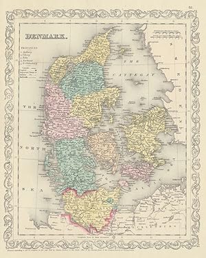
No Binding. Condition: Very Good. A fine Engraving - printed circa 1870. Mounted and ready to frame. A fine opportunity to purchase an attractive and decorative engraved Map of Denmark.
Language: English
Seller: K Books Ltd ABA ILAB, York, YORKS, United KingdomK Books Ltd ABA ILAB
Contact seller5-star sellerCondition: Used - Very good
US$ 27.62
US$ 26.14 shippingShips from United Kingdom to U.S.A.Quantity: 1 available
No Binding. Condition: Very Good. A fine Engraving - printed circa 1870. Mounted and ready to frame. A fine opportunity to purchase an attractive and decorative engraved Map of Denmark.

Published by Orr & Comp Amen Corner Paternoster Row Ca1870 1870
Seller: PROCTOR / THE ANTIQUE MAP & BOOKSHOP, DORCHESTER, United KingdomPROCTOR / THE ANTIQUE MAP & BOOKSHOP
Contact seller5-star sellerCondition: Used
US$ 30.38
US$ 26.81 shippingShips from United Kingdom to U.S.A.Quantity: 1 available
Size of engraved surface: 25cm x 30cm. In very good condition. Some faint marks on left hand edge. Some pencil markings and coloured underlining Uncoloured.
Language: English
Published by Tallis 1850
Seller: K Books Ltd ABA ILAB, York, YORKS, United KingdomK Books Ltd ABA ILAB
Contact seller5-star sellerCondition: Used - Very good
US$ 69.04
US$ 26.14 shippingShips from United Kingdom to U.S.A.Quantity: 1 available
No Binding. Condition: Very Good. Antique hand-coloured map. Plate size approx. 13.5 x 10.5 inches, 34 x 26 cms. Mounted and ready to frame. VERY GOOD. *Decorative and unusual. circa 1850.
Denmark and Part of Norway - an Antique Map
Denmark and Part of Norway - an Antique Engraved Map, Circa 1844
Language: English
Seller: K Books Ltd ABA ILAB, York, YORKS, United KingdomK Books Ltd ABA ILAB
Contact seller5-star sellerCondition: Used - Very good
US$ 48.33
US$ 26.14 shippingShips from United Kingdom to U.S.A.Quantity: 1 available
No Binding. Condition: Very Good. A fine antique map in very good condition - printed in circa 1844. Mounted (matted) and ready to frame. Engraved size approx 16 x 13 Ins, 41 x 33 Cms. Mounted size approx 19 x 16 in, 49 x 41cm. Coloured in outline, hand colouring contemporary. A fine engraved map of Denmark and Part of Norway. E…ngraved By Walker (illustrator).

- Hardcover
Seller: Art Source International Inc., Boulder, CO, U.S.A.Art Source International Inc.
Contact seller5-star sellerWe are excited to offer a wonderful collection of World War II maps. Over the years we have had many requests for WWII material and here it is. These maps are very detailed showing boundaries (international, department or province, arrondissement, canton or commune), roads, cart tracks, foot paths, power cables, aerial railways,… railways, tramways, narrow guage lines, windmills, windpumps, watermills, towers, chimneys, monuments, triginometrical points, forts, wireless stations, churches, belfries, chapels, calvaries, crosses, cemeteries, woods, orchards, vineyards, gardens, brushwoods, fields, rivers, canals, aqueducts, drainage channels, marshes, wells, springs, fountains, reservoirs, fords, ferries, hedges, sand dunes, quarries, and sand pits. This map measures 26 inches by 22 inches.
MAP OF NORWAY, SWEDEN & DENMARK - Original Antique Map, Printed c 1785
MAP OF NORWAY, SWEDEN & DENMARK - Original Antique Map, Printed c 1785
Language: English
Seller: K Books Ltd ABA ILAB, York, YORKS, United KingdomK Books Ltd ABA ILAB
Contact seller5-star sellerCondition: Used - Very good
US$ 62.14
US$ 26.14 shippingShips from United Kingdom to U.S.A.Quantity: 1 available
No Binding. Condition: Very Good. Original antique map, engraved for Millar's New Complete & Universal System of Geography. Colouring not contemporary, but delicately and expertly done. Mounted (matted) and ready to frame. Cartouche. No date of publication. Includes Finland, the Shetland Isles and Lapland.

Language: English
Published by Johnson & Browning, NY 1862
- First Edition
- Map
Seller: Dorley House Books, Inc., Hagerstown, MD, U.S.A.Dorley House Books, Inc.
Contact seller4-star sellerCondition: Used - Very good
US$ 145.00
US$ 8.65 shippingShips within U.S.A.Quantity: 1 available
No Binding. Condition: Very Good. 1st. scale approximately 1'=25 miles; very nice.Single sheet suitable for framing. Handcolored Map (illustrator).
Norway, Sweden Denmark & Finland - Antique Hand Coloured Map
NORWAY, SWEDEN, DENMARK & FINLAND - Antique Hand-Coloured Map
Language: English
Seller: K Books Ltd ABA ILAB, York, YORKS, United KingdomK Books Ltd ABA ILAB
Contact seller5-star sellerCondition: Used - Very good
US$ 69.04
US$ 26.14 shippingShips from United Kingdom to U.S.A.Quantity: 1 available
No Binding. Condition: Very Good. A splendid original antique coloured map . Mounted (matted) and ready to frame . A wonderful opportunity to acquire a vintage map, ca. 1850.

Language: English
- Hardcover
- Print on Demand
Seller: S N Books World, Delhi, , IndiaS N Books World
Contact seller5-star sellerLeatherBound. Condition: New. BOOKS ARE EXEMPT FROM IMPORT DUTIES AND TARIFFS; NO EXTRA CHARGES APPLY. Leatherbound edition. Condition: New. Leather Binding on Spine and Corners with Golden leaf printing on spine. Bound in genuine leather with Satin ribbon page markers and Spine with raised gilt bands. Pages: 116. A perfect gift… for your loved ones. Reprinted from 1968 edition. NO changes have been made to the original text. This is NOT a retyped or an ocr'd reprint. Illustrations, Index, if any, are included in black and white. Each page is checked manually before printing. As this print on demand book is reprinted from a very old book, there could be some missing or flawed pages, but we always try to make the book as complete as possible. Fold-outs, if any, are not part of the book. If the original book was published in multiple volumes then this reprint is of only one volume, not the whole set. IF YOU WISH TO ORDER PARTICULAR VOLUME OR ALL THE VOLUMES YOU CAN CONTACT US. Resized as per current standards. Sewing binding for longer life, where the book block is actually sewn (smythe sewn/section sewn) with thread before binding which results in a more durable type of binding. Language: English Pages: 116.

Published by Edinburgh: Published by Gall & Inglis., 1859. 1859
- Map
Seller: Spike Hughes Rare Books ABA, Innerleithen, , United KingdomSpike Hughes Rare Books ABA
Contact seller5-star sellerCondition: Used
US$ 48.33
US$ 34.86 shippingShips from United Kingdom to U.S.A.Quantity: 1 available
Lithograph, 640 X 530 mm. overall, image 550 X 460 mm, original hand-colouring, fold at centre. [From The Edinburgh Imperial Atlas of 1859 with number XXV in margin].
DENMARK, NORWAY & SWEDEN - an Original Antique Engraved Map, Printed 1756, Hand-Coloured
DENMARK, NORWAY & SWEDEN - an Original Antique Engraved Map, Printed 1756, Hand-Coloured
Language: English
Seller: K Books Ltd ABA ILAB, York, YORKS, United KingdomK Books Ltd ABA ILAB
Contact seller5-star sellerCondition: Used - Very good
US$ 82.85
US$ 26.14 shippingShips from United Kingdom to U.S.A.Quantity: 1 available
No Binding. Condition: Very Good. A splendid original antique engraved map. Hand-coloured, colouring not contemporary but delicately and expertly executed. Mounted - matted - and ready to frame . Very good condition. Printed 1756. A fine map showing the Scandinavian countries of Norway, Sweden and Denmark. NOLIN (illustrator).

Published by Johnson & Browning, Richmond, VA 1861
- Softcover
- First Edition
- Art Print
Seller: Dorley House Books, Inc., Hagerstown, MD, U.S.A.Dorley House Books, Inc.
Contact seller4-star sellerCondition: Used - Very good
US$ 175.00
US$ 8.65 shippingShips within U.S.A.Quantity: 1 available
Unbound. Condition: Very Good. 1st. Plate #72, 73; lovely double page hand-colored map; of Prussia, Norway, Sweden & Denmark at the beginning of the US Civil War, decorative strapwork border; w/ Counties, cities, roads, rivers, railroads, wagon roads,canals, ports, etc & with 2 engravings Size: 17" x 24.5". Handcolored Map (illu…strator).
Published by Odense University Press, Odense 1999
- Hardcover
Seller: Expatriate Bookshop of Denmark, Svendborg, , DenmarkExpatriate Bookshop of Denmark
Contact seller5-star sellerCondition: Used
US$ 65.00
US$ 149.30 shippingShips from Denmark to U.S.A.Quantity: 1 available
orig.wrappers. 41x31cm, 180,(36) pp, A rubberstamp to inside-front-cover. A small (1cm) tear to frint interior hinge. This is a portfolio consisting of three separate paper-bound books totalling 180pp + 33 large folding maps, loose, as issued, in a large ( elephant folio) stiff cardboard portfolio. Bilingual Danish/ English text…. Minor rubbing. A small removed-label-mark to cover. VG. 33 folding map plates (illustrator).

Published by Liverpool: George Philip & Son, [1858]. 1858
- Map
Seller: Spike Hughes Rare Books ABA, Innerleithen, , United KingdomSpike Hughes Rare Books ABA
Contact seller5-star sellerCondition: Used
US$ 66.28
US$ 34.86 shippingShips from United Kingdom to U.S.A.Quantity: 1 available
Litho. map, image size 600 X 500 mm., outline colouring, folded at centre. [From Philips' New General Atlas, 1858, with the plate number 32 in lower right margin].
Published by Charles Desilver, Philadelphia 1856
- Map
Seller: Main Street Fine Books & Mss, ABAA, Galena, IL, U.S.A.Main Street Fine Books & Mss, ABAA
Contact seller5-star seller[Philadelphia]: Charles Desilver, 1856. 12½" X 14½" (image 9 3/4" X 12"). Hand colored. Near fine. Bright, lovely and large margined example of this fine map, with delicate beautiful hand coloring and handsome ornamental border.
Published by Odense University Press, Odense 1993
Seller: Expatriate Bookshop of Denmark, Svendborg, , DenmarkExpatriate Bookshop of Denmark
Contact seller5-star sellerCondition: Used
US$ 69.00
US$ 149.30 shippingShips from Denmark to U.S.A.Quantity: 1 available
orig.wrappers. 41x31cm, 106,(27) pp, Corner bumped. This is a portfolio consisting of two separate paper-bound books totalling 106pp + 27 large folding maps, loose, as issued, in a large ( elephant folio) stiff cardboard portfolio. Bilingual Danish/ English text. Rubbed. Rubberstamp to inside-front-cover. Cover faded. VG. 27pp m…ap plates (illustrator).

- Map
Seller: Geographicus Rare Antique Maps, Brooklyn, NY, U.S.A.Geographicus Rare Antique Maps
Contact seller4-star sellerVery good. Minor foxing at places. Blank on verso. Size 9.5 x 8 Inches. This is a scarce 1845 Thomas Ewing map of Denmark. It covers all of Denmark inclusive of the Duchies of Schleswig and Holstein. Numerous towns, rivers, roads, mountains and other important topographical features are noted throughout. During the time this map… was made, Denmark was on the brink of the First Schleswig War between Prussia, Germany and the duchies of Holstein and Schleswig against the Kingdom of Denmark. In 1848, when the king of Denmark, Frederick VII, proposed that the Duchies of Schleswig and Holstein be formally recognized as part of the Danish Kingdom, the predominantly German population of the two duchies rebelled for a free constitution, resulting in war. Denmark ultimately won the war and retained control of Schleswig-Holstein. This map was published in 1845 by Oliver and Boyd as part of Ewing's New General Atlas .

- Map
Seller: Geographicus Rare Antique Maps, Brooklyn, NY, U.S.A.Geographicus Rare Antique Maps
Contact seller4-star sellerVery good. Blank on verso. Original platemark visible. Slight overall toning. Size 10 x 8 Inches. This is an attractive example of the 1828 Malte-Brun map of Denmark. The map covers all of Denmark inclusive of the Duchy of Holstein. The Kattegat (Cattegat) is also identified. At this time in history, Scandinavia was in the midst… of a prolonged period of peace and prosperity that led to a cultural and population boom. Various, important rivers, islands, cities and other topographical details are noted. This map was published by Samuel Walker in 1828 as part of the American edition of Conrad Malte-Brun's System of Geography , Vol. I.

- Map
Seller: Geographicus Rare Antique Maps, Brooklyn, NY, U.S.A.Geographicus Rare Antique Maps
Contact seller4-star sellerVery good. Overall toning. Blank on verso. Size 10 x 12 Inches. A fine example S. A. Mitchell Senior's 1850 map of Denmark. Shows cities, roadways, rail lines, canals, and some topographical features. Color coded according to province, including the Duchy of Holstein. Includes parts of adjacent Sweden and Germany. Dated and copy…righted 1850.

Russia in Europe, Sweden and Norway. Map of Denmark. Map of Holland and Belgium.
1887 Bradley Map of European Russia, Scandinavia, Holland, Belgium and Denmark.
- Map
Seller: Geographicus Rare Antique Maps, Brooklyn, NY, U.S.A.Geographicus Rare Antique Maps
Contact seller4-star sellerVery good. Blank on verso. Size 11.5 x 14.5 Inches. This is a fine example of William M. Bradley's 1887 map of Russia, Norway, Sweden, Holland Belgium and Denmark. Maps of Denmark, Holland and Belgium relegated to insets on the left hand side of the sheet. The larger map covers Scandinavia and the european portion of Russia from… the Arctic Ocean to Turkey, including the european portions of Russia as well as Finland, Ukraine, Latvia, Lithuania and estonia. Denmark is covered in full, from the Skagerrak to the Baltic Sea. Holland and Belgium are covered from the North Sea to France. Russia at this time was under the suzerainty of Tzar Alexander the II. Alexander is best known for his liberal reforms including the emancipation Reform of 1861. The Reform, considered the most important event in 19th century Russian history, liberated Russia's countless serfs. In 1830, the Belgian Revolution led to the secession of Belgium from the United Kingdom of Netherlands into the independent Kingdom of Belgium. Though Belgium had successfully made itself independent, the Netherlands refused to recognize the new country until the 1839 Treaty of London. Meanwhile Scandinavia and Denmark at the time were in the midst of a prolonged period of peace and prosperity that led to a cultural and economic boom. Various towns, cities, rivers and an assortment of additional topographical details are noted. Map is color coded according to regional and political boundaries with elevation rendered by hachure. Copyrighted 1887 by Wm. M. Bradley & Bro., for inssue as plate no. 112 in the 1887 edition of Mitchell's New General Atlas . References: Rumsey 0594.061.

Russia in Europe, Sweden and Norway. / Map of Denmark. / Map of Holland and Belgium.
1864 Mitchell Map of Russia, Scandinavia, Denmark, Holland and Belgium
- Map
Seller: Geographicus Rare Antique Maps, Brooklyn, NY, U.S.A.Geographicus Rare Antique Maps
Contact seller4-star sellerVery good condition. Blank on verso. Size 11 x 13.75 Inches. A beautiful example of S. A. Mitchell Jr.'s 1864 map of Russia, Norway, Sweden, Holland Belgium and Denmark. Maps of Denmark, Holland and Belgium relegated in insets on the left hand side of the map. Denotes both political and geographical details. Extends as far south… and west as the boot of Italy and as far east as the Caspian Sea and the Gulf of Obi. One of the most attractive American atlas maps of this region to appear in the mid 19th century. Features the floral border typical of Mitchell maps from the 1860-65 period. Prepared by S.A. Mitchell for inclusion as plate no. 64 in the 1864 issue of Mitchell's New General Atlas . Dated and copyrighted, 'Entered according to Act of Congress in the Year 1860 by S. Augustus Mitchell in the Clerk's Office of the District Court of the U.S. for the Eastern District of Pennsylvania. References: Rumsey 0565.033 (1860 edition). Phillips (Atlases) 831. New York Public Library, Map Division, 1510828.

- Map
Seller: Geographicus Rare Antique Maps, Brooklyn, NY, U.S.A.Geographicus Rare Antique Maps
Contact seller4-star sellerVery good. Even overall toning. Blank on verso. Size 12.5 x 10.5 Inches. This is an 1849 Samuel Augustus Mitchell map of Denmark. The map depicts all of Denmark inclusive of the Duchy of Holstein. A list along the upper left border notes Denmark's five Provinces: Aalborg, Viborg, Ribe, Aarhuus, and To Oldenburg. Political and to…pographical features are noted and color coded with elevation rendered by hachure. The whole is engraved and colored in Mitchell's distinctive style with green border work and vivid pastels. Mitchell published this map in his atlas from 1846 to the late 1850s before discontinuing the series and selling his map plates to DeSilver. This map was issued in the 1849 edition of the New Universal Atlas . It was the last edition of that atlas to be published by Mitchell prior to selling the plates and rights to the atlas to Thomas Cowperthwait in 1850. References: Rumsey 0545.057.


