
Order Total (1 Item Items):
Shipping Destination:

Denmark by Map, First Edition (8 results)
Skip to main search results
Search filters
Product Type
- All Product Types
- Books (2)
- Magazines & Periodicals (No further results match this refinement)
- Comics (No further results match this refinement)
- Sheet Music (No further results match this refinement)
- Art, Prints & Posters (1)
- Photographs (No further results match this refinement)
- Maps (5)
- Manuscripts & Paper Collectibles (No further results match this refinement)
Condition Learn more
- New (No further results match this refinement)
- As New, Fine or Near Fine (1)
- Very Good or Good (3)
- Fair or Poor (No further results match this refinement)
- As Described (4)
Binding
Collectible Attributes
- First Edition (8)
- Signed (No further results match this refinement)
- Dust Jacket (1)
- Seller-Supplied Images (8)
- Not Print on Demand (8)
Language (2)
Free Shipping
- Free Shipping to U.S.A. (No further results match this refinement)
Seller Location
Seller Rating
-

Denmark (Nations of the Modern World Series)
Language: English
Published by Ernest Been Limited, London, 1970
ISBN 10: 0510381111 ISBN 13: 9780510381110
Seller: Dorley House Books, Inc., Hagerstown, MD, U.S.A.
Seller rating 4 out of 5 stars

First Edition
Hardcover. Condition: Near Fine. Dust Jacket Condition: Very Good. 16 pages b/w Illus + Map (illustrator). 1st. 1st printing; dj w/unclipped price; 256 clean, unmarked pages/index; owner's label.
-
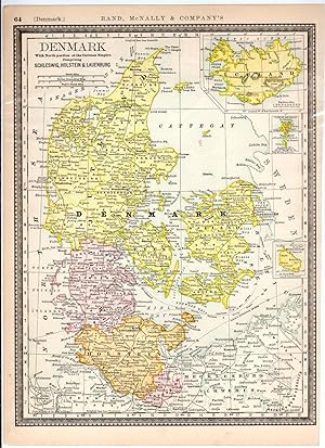
MAP: "Denmark".from the New Indexed Atlas of the World
Published by Rand McNally & Co, Chicago, IL, 1887
Seller: Dorley House Books, Inc., Hagerstown, MD, U.S.A.
Seller rating 4 out of 5 stars
First Edition
Unbound. Condition: Very Good. Handcolored Map (illustrator). 1st. very nice w/decorative border; inset shows Iceland .suitable for framing Size: 16.5" x 11.25".
-

MAP: Johnson's Prussia, Norway, Sweden and Denmark (& Finland)
Language: English
Published by Johnson & Browning, NY, 1862
Seller: Dorley House Books, Inc., Hagerstown, MD, U.S.A.
Seller rating 4 out of 5 stars
Map First Edition
No Binding. Condition: Very Good. Handcolored Map (illustrator). 1st. scale approximately 1'=25 miles; very nice!.Single sheet suitable for framing.
-

MAP: "Johnson's Map of Prussia, Norway, Sweden & Denmark (1861)'.from Johnson's New Illustrated (Steel Plate) Family Atlas, 1861
Published by Johnson & Browning, Richmond, VA, 1861
Seller: Dorley House Books, Inc., Hagerstown, MD, U.S.A.
Seller rating 4 out of 5 stars
Art / Print / Poster First Edition
Unbound. Condition: Very Good. Handcolored Map (illustrator). 1st. Plate #72, 73; lovely double page hand-colored map; of Prussia, Norway, Sweden & Denmark at the beginning of the US Civil War, decorative strapwork border; w/ Counties, cities, roads, rivers, railroads, wagon roads,canals, ports, etc & with 2 engravings Size: 17" x 24.5".
-

Denmark, Sweden, Norway and Lapland.
Publication Date: 1835
Seller: Geographicus Rare Antique Maps, Brooklyn, NY, U.S.A.
Association Member: ABAA ESA ILAB
Seller rating 4 out of 5 stars
Map First Edition
1st Edition. Very good. Original platemark visible. Minor spotting at places. Blank on verso. Size 10.5 x 8.5 Inches. This is affine example of T. G. Bradford's 1835 map of Sweden, Norway, Denmark and Lapland. Centered on the Gulf of Bothnia, it covers all of Scandinavia, from Finmark to Denmark. Towns, rivers, mountains, lakes, and various other important topographical details are noted. Elevation throughout is rendered by hachure and political and regional territories are color coded. The legendary and semi-mythical whirlpool known as the Maelstrom (Mahlstrom) in northwestern Norway is noted. This legendary whirlpool was the inspiration for Edgar Allen Poe's classic tale 'Descent into the Maelstrom.' In reality, it is a periodic and powerful current caused by tidal variations in the region. As this map was being printed, all of Scandinavia was in the midst of a prolonged period of peace and prosperity that led to a cultural and population boom. The map was published as plate no. 96 in Thomas G. Bradford's 1835 Comprehensive Atlas Geographical, Historical and Commercial . Bradford's atlas, published in 1835 was an important work on many levels. First, it was one of the first American atlases to follow an encyclopedic format, offering readers extensive geographical and statistical tables to supplement the maps themselves. Second, it was published in Boston and influenced the city's rise as a publishing center later in the 19th century (at the time most publishing in the United States was restricted to New York and Philadelphia). Third, this atlas was the first to contain a separate and specific map showing the Republic of Texas. Fourth and finally, Bradford's atlas in some instances broke the Euro-centric mold regarding atlas production. Among other things, Bradford focused his atlas on the Americas and abandoned the classical decoration common in European atlases in favor of a more informational and inherently American approach. Bradford published this atlas in several editions and with various partners. The first edition was published by William D. Ticktor and did not contain the iconic Republic of Texas map (although we have in fact seen Ticktor examples with a Texas map, suggesting, against conventional wisdom, that there may have been two Ticktor editions). The second official edition, published in the same year by the American Stationers Company, was the first to contain the Republic of Texas map, which is based on Austin's map, with two pages of descriptive text. A third edition was issued in 1836, also by American Stationers (though still dated 1835), and contained an unaltered Republic of Texas map with only a single page of descriptive test. A fourth edition appeared later, possibly 1837, and included an updated and revised map of Texas that replaces the old Mexican land grants with new inchoate counties. The maps from this atlas are an important addition to any collection focusing on early American cartography and Republic of Texas cartography. All maps in this atlas, though not specifically noted as such, were most likely engraved by G. W. Boynton of Boston, who also engraved most of the maps for Bradford's later publication. References: Rumsey 2643.106 (1838 edition).
-

A New Map of Denmark and Holstein.
Publication Date: 1794
Seller: Geographicus Rare Antique Maps, Brooklyn, NY, U.S.A.
Association Member: ABAA ESA ILAB
Seller rating 4 out of 5 stars
Map First Edition
1st Edition. Very good. Minor marginal soiling. Original platemark visible. Blank on verso. Size 11.75 x 9.25 Inches. A finely detailed first edition 1794 map of Denmark and Holstein, by Robert Wilkinson. Denmark prospered greatly in the last decades of the 18th century because its neutral status allowed it to trade with both sides in the many contemporary wars. In the Napoleonic Wars, Denmark originally tried to pursue a policy of neutrality to continue the lucrative trade with both France and Great Britain and joined the League of Armed Neutrality with Russia, Sweden and Prussia. engraved by Thomas Conder for the 1794 first edition of Robert Wilkinson's General Atlas .
-

Denmark Sweden and Norway.
Publication Date: 1833
Seller: Geographicus Rare Antique Maps, Brooklyn, NY, U.S.A.
Association Member: ABAA ESA ILAB
Seller rating 4 out of 5 stars
Map First Edition
1st Edition. Very good. Minor foxing. Original platemark visible. Size 13.5 x 11.5 Inches. This is an impressive 1833 first edition map of Scandinavia by David H. Burr. The map covers Denmark, Norway and Sweden in detail and identifies various cities, towns, rivers, mountain passes and an assortment of additional topographical details. The legendary and semi-mythical whirlpool known as the Maelstrom (Mahlstrom) in northwestern Norway is noted. This legendary whirlpool was the inspiration for Edgar Allen Poe's classic tale 'Descent into the Maelstrom.' In reality, it is a periodic and powerful current caused by tidal variations in the region. As this map was being printed, all of Scandinavia was in the midst of a prolonged period of peace and prosperity that led to a cultural and population boom. According to Ristow, although Burr is credited on the title page, he left this atlas incomplete. He was appointed as topographer to the U.S. Post Office, and of the sixty-three maps finally included in this atlas, only completed eight. The rest of the maps were then completed by Illman and Pilbrow in Burr's style. This map was 'Entered according to act of Congress in the year 1833 by Illman and Pilbrow in the Clerk's office of the District Court for the Southern District of New York', but was not published until the atlas was released in 1835. Published by D. S. Stone in Burr's New Universal Atlas . References: Rumsey 4628.020. Philips (Atlases) 771.
-

Denmark.
Publication Date: 1835
Seller: Geographicus Rare Antique Maps, Brooklyn, NY, U.S.A.
Association Member: ABAA ESA ILAB
Seller rating 4 out of 5 stars
Map First Edition
1st Edition. Very good. Original platemark visible. Minor wear along original centerfold. Some offsetting. Blank on verso. Size 21 x 17 Inches. This is a beautiful map of Denmark from Sidney Hall's extremely scarce 1835 New General Atlas . It covers all of Denmark inclusive of the Duchy of Holstein and the islands of Zeeland, Funen and Laland. The Kattegat (Cattegat) is also identified. Hall notes the site for the 1801 Battle of Copenhagen under Vice Admiral Horatio Nelson and the 1807 Battle of Copenhagen under Admiral James Gambier. At this time in history, all of Scandinavia was in the midst of a prolonged period of peace and prosperity that led to a cultural and population boom. Towns, rivers, mountains, railroads, marshes and various other important topographical details are noted. Elevation throughout is rendered by hachure and political and territorial boundaries are outlined in color. Sidney Hall's New General Atlas was published from 1830 to 1857, the first edition being the most common, with all subsequent editions appearing only rarely. Most of the maps included in the first edition of this atlas were drawn between 1827 and 1828 and are most likely steel plate engravings, making it among the first cartographic work to employ this technique. Each of the maps in this large and impressive atlas feature elegant engraving and an elaborate keyboard style border. Though this is hardly the first map to employ this type of border, it is possibly the earliest to use it on such a large scale. Both the choice to use steel plate engraving and the addition of the attractive keyboard boarder are evolutions of anti-forgery efforts. Copper plates, which were commonly used for printing bank notes in the early 19th century, proved largely unsuitable due to their overall fragility and the ease with which they could be duplicated. In 1819 the Bank of England introduced a �20,000 prize for anyone who could devise a means to print unforgeable notes. The American inventors Jacob Perkins and Asa Spencer responded to the call. Perkins discovered a process for economically softening and engraving steel plates while Spencer invented an engraving lathe capable of producing complex patters repetitively - such as this keyboard border. Though Perkins and Spenser did not win the prize, their steel plate engraving technique was quickly adopted by map publishers in England, who immediately recognized its value. Among early steel plate cartographic productions, this atlas, published in 1830 by Longman Rees, Orme, Brown & Green stands out as perhaps the finest. This map was issued by Sidney Hall and published by Longman Rees, Orme, Brown & Green of Paternoster Row, London, in the 1835 edition of the Sidney Hall New General Atlas . References: Rumsey 4224.015 (1830 edition). Philips (Atlases) 758. Ristow, W., American Maps and Mapmakers: Commercial Cartography in the Nineteenth Century, p. 303-09.