Denmark by Mitchell Augustus (20 results)
Language: English
Published by [W.M. Bradley], [Philadelphia] 1886
Seller: Kaaterskill Books, ABAA/ILAB, East Jewett, NY, U.S.A.Kaaterskill Books, ABAA/ILAB
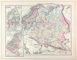
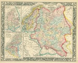
Contact seller5-star sellerHand colored map. 13.75 x 10.5 inches. Plate 112. Russia in Europe, Sweden, and Norway, insets of Map of Denmark, and Map of Holland and Belgium. Copyright by S. Augustus Mitchell 1884. From: Mitchell's New General Atlas, Containing Maps Of The Various Countries Of The World, Plans Of Cities, Etc., Embraced In Ninety-Three Quart…o Maps, Forming A Series Of One Hundred and Forty-seven Maps and Plans, Together With Valuable Statistical Tables. Also, A List Of Post-Offices Of The United States And Territories, And Also Census Of 1880 For States, Territories And Counties, Also Of Cities Of Over 10,000 Inhabitants. Philadelphia: Published By Wm. M. Bradley & Bro., No. 1026 Arch Street. 1886. Very good,minor soiling, one closed edge tear, not affecting contents.

Published by Philadelphia c.1847, Philadelphia 1847
Seller: High Ridge Books, Inc. - ABAA, South Deerfield, MA, U.S.A.High Ridge Books, Inc. - ABAA
Contact seller5-star sellerMap of Denmark, from Mitchell's Universal Atlas. fine condition. Full color by province. Denmark includes Schleswig and Holstein along with three other small German provinces in the south. This is removed from one of the latest issues of Mitchell's atlas before publication was taken up by Thomas, Cowperthwait & Co. Map no. 57.

Published by Augustus Mitchell 1860
Seller: Eureka Books, Eureka, CA, U.S.A.Eureka Books
Contact seller5-star sellerMap. Sheet, 12.5 x 15.5. Handcolored in red, blue, yellow, green, and pink First edition thus. Very good copy.

Published by Mitchell, S. Augustus, Philadelphia 1867
Seller: mediumraremaps.com, Franklin, TN, U.S.A.mediumraremaps.com
Contact seller4-star sellerCondition: Used - Very good
US$ 45.00
US$ 6.00 shippingShips within U.S.A.Quantity: 1 available
13 1/4 x 10 3/4 inches. Condition: Very good. 1867 edition. Finely colored by contemporary hand map of the Russian Empire. Map shows The map show North Cape Norway to the Georgiain the south. It shows from Denmark in the west to Orenburg in the east. There is a small inset maps of Denmark and another of Holland and Belgium. Mitc…hell, S. Augustus (illustrator).
Published by Philadelphia, PA: Augustus Mitchell. 1860
- Manuscript
Seller: Wittenborn Art Books, San Francisco, CA, U.S.A.Wittenborn Art Books
Contact seller5-star sellerCondition: Used - Good
US$ 50.00
US$ 10.00 shippingShips within U.S.A.Quantity: 1 available
Condition: Good. 15.5" x 12.75" Hand-colored lithograph, Oblong, Good with tiny loss at corner, minor tears, toning, creasing.

Seller: Art Source International Inc., Boulder, CO, U.S.A.Art Source International Inc.
Contact seller5-star sellerThis map was made by S. Augustus Mitchell for "Mitchells New General Atlas" published in 1885, by WM. M. Bradley & Co. The well maintained maps in this atlas feature Mitchell's characteristic pastel coloring and abundant details of geographical features. Russia in Europe is illustrated, with inset maps of Denmark and Holland and… Belgium. Details include the names of regions, cities, towns, transportation routes, mountain ranges, rivers and lakes. These 1885 maps offer a fascinating perspective of areas that have since undergone significant growth and change, in addition to their value as great examples of Mitchell's work. This map measures 12 inches by 10 inches.

Seller: Art Source International Inc., Boulder, CO, U.S.A.Art Source International Inc.
Contact seller5-star sellerS. Augustus Mitchell Jr. made this hand colored map in 1872. Russia in Europe, Sweden and Norway are illustrated on this map. Two inset maps of Denmark and Holland and Belgium are located on the left hand side. Regions are distinguished by bright pastel colors. Deserts, lakes, mountains, rivers, important cities and countries ar…e identified. A signature Mitchell ornate floral design frames this antique map. This map measures 13 inches by 10.5 inches.

Seller: Art Source International Inc., Boulder, CO, U.S.A.Art Source International Inc.
Contact seller5-star sellerWith characteristic floral boarders and beautiful, muted pastel coloring, these 1864 maps are fantastic examples of Mitchells work. Regions, important cities, rivers, lakes, and railroads are identified. The main map on this page illustrates Russia in Europe, Sweden, and Norway, the two insets show Denmark, and Holland and Belgi…um. This map measures 13.5 inches by 10.75 inches.

Seller: Art Source International Inc., Boulder, CO, U.S.A.Art Source International Inc.
Contact seller5-star sellerThis map was produced by S. Augustus Mitchell in 1875 for his New General Atlas. This map shows Mitchells traditional grape vine border, characteristic pastel coloring and abundant details of geographical features. Counties are distinguished by different colors. Wagon trails and major routes of transport are also shown. These 18…75 maps offer a fascinating perspective of areas that have since undergone significant growth and change, in addition to their value as great examples of Mitchell's work. This map measures 14 inches by 10.5 inches.
 More images
Published by Philadelphia : S. Augustus Mitchell, 1866. 1866
Seller: Schilb Antiquarian, Columbia, MO, U.S.A.Schilb Antiquarian
Contact seller5-star sellerCondition: Used - Very good
US$ 125.00
Free ShippingShips within U.S.A.Quantity: 1 available
No Binding. Condition: Very Good. 1866 Color Map of SCANDINAVIA Sweden Norway Denmark Russia Holland Belgium Samuel Augustus Mitchell (1790 1868) was an American geographer. Map maker: Samuel Augustus Mitchell Title: "Russian in Europe, Sweden. And Norway. Map of Holland and Belgium. Map of Denmark" Atlas Title: Mitchell's New G…eneral Atlas containing maps of the various countries of the world, plans of cities, etc., embraced in fifty-eight quarto maps, forming a series of ninety-two maps and plans, together with valuable statistical tables. Published: Philadelphia : S. Augustus Mitchell, 1866. FREE SHIPPING WORLDWIDE Wear: wear as seen in photos Publisher: Philadelphia : S. Augustus Mitchell, 1866. Size: ~17.5in X 14in (44.5cm x 35.5cm) Photos available upon request.

Seller: Art Source International Inc., Boulder, CO, U.S.A.Art Source International Inc.
Contact seller5-star sellerIn 1860 S. Augustus Mitchell Jr. took over his father's map publishing business and in that year he started publishing Mitchell's New General Atlas. Editions of the new general were issued annually until 1887. Mitchell Jr. continued publishing this atlas until 1879. The editions from 1880 to 1887 were published by Wm. M. Bradley…. This map published in 1865 is a wonderful example of Mitchell's map-making prowess with beautiful original hand-coloring. This map measures 13.5 inches by 10.5 inches.

Seller: Art Source International Inc., Boulder, CO, U.S.A.Art Source International Inc.
Contact seller5-star sellerS. Augustus Mitchell Jr. made this hand colored map for Mitchells New General Atlas in 1870. Sweden, Norway, and Russia in Europe are illustrated on the large map, with Denmark, Holland, and Belgium on smaller maps at the left of the page. Regions are distinguished by bright pastel colors. Lakes, mountains, rivers, important cit…ies and countries are identified. This map measures 13.25 inches by 10.75 inches.

Seller: Art Source International Inc., Boulder, CO, U.S.A.Art Source International Inc.
Contact seller5-star sellerThe Mitchell company was one of the first to try out the new technique of engraving on steel plates experimenting with steel almost 20 years before the rest of the publishing industry. He was printing with steel in the early 1830s; the general switch to steel was approximately 1850. During the early years of the company, Mitchel…l published mainly maps and travel guides. In 1860, Mitchell started producing "Mitchell's New General Atlas",and Mitchell Sr. retired and turned the business over to his son of the same name. The New General Atlas was published until 1893. Today Mitchell maps are sought after for their fine engraving, bright coloring, and attention to detail. They are some of the finest maps produced during this time period. This map produced in 1866, has Mitchell's unique floral border, and beautiful hand coloring. This map details Russia in Europe, Sweden, and Norway with an inset Maps of Denmark, Holland and Belgium. Countries, cities, towns, lakes, rivers, mountains, and transportation routes are noted. Each map was printed on thick paper with vibrant hand color. This map measures 13.5 inches by 10.75 inches.

Published by Philadelphia 1846
- First Edition
- Art Print
Seller: Trillium Antique Prints & Rare Books, Franklin, TN, U.S.A.Trillium Antique Prints & Rare Books
Contact seller3-star sellerCondition: Used - Fine
US$ 135.00
US$ 10.00 shippingShips within U.S.A.Quantity: 1 available
Condition: Fine. 1st Edition. This hand-colored map is from Samuel Augustus Mitchell's "A New Universal Atlas Containing Maps of the various Empires, Kingdoms, States and Republics of the World. With a special map of each of the United States, Plans of Cities &c". The work was published in Philadelphia by the Author in 1846. ---… Samuel Augustus Mitchell (1792-1868) and his sons were leading map publishers in the United States in the 19th century. Mitchell moved to Philadelphia c1830 in the hopes to improve geography textbooks and American cartographical information. He acquired the rights to Tanner's "New Universal Atlas" (first published in 1836), and issued his first printing of the work in 1846. --- The work is in very good to excellent condition overall. There may be some light toning or spotting to the plates. There may be a few minor imperfections or faint marks to be expected with age. Please review the image carefully for condition and contact us with any questions. --- Paper Size ~ 14" by 17 1/2".

Seller: Art Source International Inc., Boulder, CO, U.S.A.Art Source International Inc.
Contact seller5-star sellerThe Mitchell company was one of the first to try out the new technique of engraving on steel plates, experimenting with steel almost 20 years before the rest of the publishing industry. He was printing with steel in the early 1830s; the general switch to steel engraving was approximately 1850. During the early years of the compa…ny, Mitchell published mainly maps and travel guides. In 1860, Mitchell started producing "Mitchell's New General Atlas". Mitchell Sr. retired and turned the business over to his son of the same name. The New General Atlas was published until 1893. Today Mitchell maps are sought after for their fine engraving, bright coloring, and attention to detail. They are some of the finest maps produced in the 1860's. This map, produced in 1863, shows Mitchell's famous flower border, which is only seen in the early editions of his atlases. This map shows Russia, Sweden, Norway, Denmark, Holland and Belgium. This map measures 13.5 inches by 11 inches.

Seller: Art Source International Inc., Boulder, CO, U.S.A.Art Source International Inc.
Contact seller5-star sellerThis map of Russia in Europe, Sweden, Norway, Denmark, Holland, and Belgium was produced by Augustus Mitchell in 1879 for his New General Atlas. Highlights of this map are Mitchells traditional grapevine border, characteristic pastel coloring and abundant details of geographical features. This 1879 map offers a fascinating persp…ective of areas that have since undergone significant growth and change, in addition to the value as great examples of Mitchell's classic map-making style. This map measures 14 inches by 11 inches.

Seller: Art Source International Inc., Boulder, CO, U.S.A.Art Source International Inc.
Contact seller5-star sellerThis beautiful map of Russia in Europe, Sweden, Norway, Denmark, Holland, and Belgium was made by S. Augustus Mitchell, in 1860, for his New General Atlas. This map features bright original hand coloring that differentiates regions and country sections, a decorative floral border, and fine detailing (including cities, rivers, la…kes, and other geographical features). This map measures 13.5 inches by 10.5 inches.

Seller: Art Source International Inc., Boulder, CO, U.S.A.Art Source International Inc.
Contact seller5-star sellerThis exceptional map is from "Mitchells New General Atlas" published by S. Augustus Mitchell, Jr in 1861. This steel plate engraved map has original hand coloring and crisp engraved lines. Maps from this 1861 ( 2nd edition) atlas have become very difficult to acquire. Surrounding these maps of Russia in Europe, Sweden and Norway…, Holland and Belgium, Denmark is a ' inch floral border. Counties, provinces, many cities,rivers and lakes are identified on this beautiful map. This map measures 13.75 inches by 10.75 inches.

Seller: Art Source International Inc., Boulder, CO, U.S.A.Art Source International Inc.
Contact seller5-star sellerThis map was produced by Augustus Mitchell in 1878 for his New General Atlas. Highlights of this map are Mitchells traditional grapevine border, characteristic pastel coloring and abundant details of geographical features. This map of Russia in Europe, Sweden and Norway includes two inset maps of Holland and Belgium, as well as…Denmark. Coutnries are distinguished by color. This 1878 map offers a fascinating perspective of areas that have since undergone significant growth and change, in addition to the value as great examples of Mitchell's classic mapmaking style. This map measures 13.5 inches by 10.5 inches.

Seller: Art Source International Inc., Boulder, CO, U.S.A.Art Source International Inc.
Contact seller5-star sellerThis map of Denmark was issued as part of Samuel Augustus Mitchell's "New Universal Atlas" in 1846. This was the very first year of publication of this atlas. The atlas was comprised of finely engraved and delicately colored maps and plans of all areas of the world. A resurgence of atlas production in North America during the 18…40's and 1850's reflected an emerging mass market fueled by prosperity and mobility. Mitchell was in the right place at the right time. A native of Scotland, Mitchell became a prolific publisher of geographical works when he emigrated to the United States. Walter Ristow, famous map historian, notes that Mitchell employed as many as 250 persons in his Philadelphia establishment, which he took over from Henry S. Tanner in the mid-nineteenth century. We hope you enjoy this very rare Mitchell map! This map measures 9.5 inches by 11.75 inches.


