
Order Total (1 Item Items):
Shipping Destination:

Devon Cornwall Road Map (22 results)
Skip to main search results
Search filters
Product Type
- All Product Types
- Books (21)
- Magazines & Periodicals (No further results match this refinement)
- Comics (No further results match this refinement)
- Sheet Music (No further results match this refinement)
- Art, Prints & Posters (No further results match this refinement)
- Photographs (No further results match this refinement)
- Maps (1)
- Manuscripts & Paper Collectibles (No further results match this refinement)
Condition Learn more
- New (1)
- As New, Fine or Near Fine (No further results match this refinement)
- Very Good or Good (10)
- Fair or Poor (5)
- As Described (6)
Binding
- All Bindings
- Hardcover (No further results match this refinement)
- Softcover (12)
Collectible Attributes
- First Edition (No further results match this refinement)
- Signed (No further results match this refinement)
- Dust Jacket (1)
- Seller-Supplied Images (7)
- Not Print on Demand (22)
Language (2)
Free Shipping
Seller Location
Seller Rating
-

Devon and Cornwall a-Z Road Map
Language: English
Published by Geographers' A-Z Map Company, Limited, 2018
ISBN 10: 1843489449 ISBN 13: 9781843489443
Map
Condition: Good. Pages intact with minimal writing/highlighting. The binding may be loose and creased. Dust jackets/supplements are not included. Stock photo provided. Product includes identifying sticker. Better World Books: Buy Books. Do Good.
-

Devon and Cornwall (A-Z Devon and Cornwall Road Map)
Language: English
Published by Geographers' A-Z Map Co Ltd, 1983
ISBN 10: 0850391830 ISBN 13: 9780850391831
Seller: WorldofBooks, Goring-By-Sea, WS, United Kingdom
Seller rating 5 out of 5 stars

Paperback. Condition: Good. The book has been read but remains in clean condition. All pages are intact and the cover is intact. Some minor wear to the spine.
-
Devon & Cornwall Road Map (A-Z Road Map)
Language: English
Published by Geographers' A-Z Map Co Ltd, 2018
ISBN 10: 1843489449 ISBN 13: 9781843489443
Seller: WorldofBooks, Goring-By-Sea, WS, United Kingdom
Seller rating 5 out of 5 stars
Paperback. Condition: Fair. A readable copy of the book which may include some defects such as highlighting and notes. Cover and pages may be creased and show discolouration.
-
Devon and Cornwall (A-Z Devon and Cornwall Road Map)
Language: English
Published by HarperCollins Publishers, United Kingdom, 1983
ISBN 10: 0850391830 ISBN 13: 9780850391831
Seller: WorldofBooks, Goring-By-Sea, WS, United Kingdom
Seller rating 5 out of 5 stars
Paperback. Condition: Very Good. Major alterations to this edition include: 9S-8U - the new route of the A30 is shown as under construction; 12G - Fraddon By-Pass is shown as open; 14E - Penryn By-Pass is shown as open. The book has been read, but is in excellent condition. Pages are intact and not marred by notes or highlighting. The spine remains undamaged.
-

Devon and Cornwall Road Map
Language: English
Published by Geographers' A-Z Map Co Ltd, 2006
ISBN 10: 1843483718 ISBN 13: 9781843483717
Condition: Good. Most items will be dispatched the same or the next working day. A copy that has been read but remains in clean condition. All of the pages are intact and the cover is intact and the spine may show signs of wear. The book may have minor markings which are not specifically mentioned.
-

Devon and Cornwall Road Map
Language: English
Published by Geographers' A-Z Map Co Ltd, 2006
ISBN 10: 1843483718 ISBN 13: 9781843483717
Seller: WorldofBooks, Goring-By-Sea, WS, United Kingdom
Seller rating 5 out of 5 stars
Paperback. Condition: Fair. A readable copy of the book which may include some defects such as highlighting and notes. Cover and pages may be creased and show discolouration.
-
Devon and Cornwall Road Map
Language: English
Published by Geographers' A-Z Map Co Ltd, 2006
ISBN 10: 1843483718 ISBN 13: 9781843483717
Seller: WorldofBooks, Goring-By-Sea, WS, United Kingdom
Seller rating 5 out of 5 stars
Paperback. Condition: Very Good. The book has been read, but is in excellent condition. Pages are intact and not marred by notes or highlighting. The spine remains undamaged.
-

Devon & Cornwall Road Map (A-Z Road Map)
Language: English
Published by Geographers A-Z Map Co Ltd, 2015
ISBN 10: 1843489449 ISBN 13: 9781843489443
Condition: Very Good. Most items will be dispatched the same or the next working day. A copy that has been read, but is in excellent condition. Pages are intact and not marred by notes or highlighting. The spine remains undamaged.
-

Condition: Good. Most items will be dispatched the same or the next working day. A copy that has been read but remains in clean condition. All of the pages are intact and the cover is intact and the spine may show signs of wear. The book may have minor markings which are not specifically mentioned.
-
A-Z Devon and Cornwall Road Map: Devon and Cornwall
Language: English
Published by Geographers' A-Z Map Co Ltd, 1983
ISBN 10: 0850391830 ISBN 13: 9780850391831
Condition: acceptable. Ausreichend/Acceptable: Exemplar mit vollst�ndigem Text und s�mtlichen Abbildungen oder Karten. Schmutztitel oder Vorsatz k�nnen fehlen. Einband bzw. Schutzumschlag weisen unter Umst�nden starke Gebrauchsspuren auf. / Describes a book or dust jacket that has the complete text pages (including those with maps or plates) but may lack endpapers, half-title, etc. (which must be noted). Binding, dust jacket (if any), etc may also be worn.
-
Devon and Cornwall (A-Z Devon and Cornwall Road Map)
Language: English
Published by Geographers' A-Z Map Co Ltd, 1983
ISBN 10: 0850391830 ISBN 13: 9780850391831
map. Condition: Acceptable. Please see the condition note after this for details, if this is missing please consider Acceptable to mean poor quality that could include major staining, water damage, writing, missing dustjacket, etc etc. Our books are dispatched from a Yorkshire former cotton mill. We list via barcode/ISBN so please note that the images are stock images and may not be the exact copy you receive, furthermore the details about edition and year might not be accurate as many publishers reuse the same ISBN for multiple editions and as we simply scan a barcode or enter an ISBN we do not check the validity of the edition data when listing. If you're looking for an exact edition please don't order (at least not without checking with us first, although we don't always have time to check). We aim to dispatch prompty, the service used will depend on order value and book size. We can ship to most countries, see our shipping policies. Payment is via Abe only.
-

The R.A.C. County Road Map and Gazetteer, Number 9: Devon and Cornwall (Double Number)
Published by The Royal Automobile Club 0, UK
Seller: The Book Exchange, Macclesfield, CHESH, United Kingdom
Seller rating 5 out of 5 stars
Soft cover. Condition: Very Good. Softcover, not ex. library. 104 pages, illustrated with colour maps and b/w photographs. Contents clean, tight and bright. Undated, cover price is 2/- net. Thought to be 1930's. Excellent condition, no rusting on staples. Book.
-

Devon and Cornwall Road Map
Language: English
Published by Geographers' A-Z Map Co Ltd, 2007
ISBN 10: 184348532X ISBN 13: 9781843485322
US$ 29.74
US$ 16.27 shipping
Ships from United Kingdom to U.S.A.Quantity: 1 available
Add to basketmap. Condition: Good. Our good condition books are generally good for reading but not for gifting or collecting. They could have imperfections such as creasing, fanning, inscriptions, margin notes, yellowing, staining on edge or cover or pages, bumps, scuffs, etc etc (sometimes multiple of these). It's a wide category that encompasses anything that isn't almost-new down to anything that is slightly better than poor. We would NOT recommend gifting Good books - these should be considered reading copies. Our books are dispatched from a Yorkshire former cotton mill. We list via barcode/ISBN so please note that the images are stock images and may not be the exact copy you receive, furthermore the details about edition and year might not be accurate as many publishers reuse the same ISBN for multiple editions and as we simply scan a barcode or enter an ISBN we do not check the validity of the edition data when listing. If you're looking for an exact edition please don't order (at least not without checking with us first, although we don't always have time to check). We aim to dispatch prompty, the service used will depend on order value and book size. We can ship to most countries, see our shipping policies. Payment is via Abe only.
-
Philips' Ten Sheet Road Map of England & Wales. Sheet 1. (Devon & Cornwall).
Published by London: george Philip n d, 1927
Seller: Richard Roberts Bookseller., KILMARNOCK, United Kingdom
Seller rating 5 out of 5 stars
Coloured folding map on paper. Scale 3 miles to one Inch. Open size:- 90 x 75cm. Folded size:- 19 x 10cm. Showing Ministry of Transport's New Road Numbering. (Class I Roads A. in red. Class II. Roads B. in blue. The original pictorial card covers are lightly faded. This apart a very good copy free from tears.
-
Devon & Cornwall Road Map
Language: English
Published by Geographers A-Z Map Company, 2011
ISBN 10: 184348532X ISBN 13: 9781843485322
US$ 26.75
US$ 20.09 shipping
Ships from United Kingdom to U.S.A.Quantity: 1 available
Add to basketMap. Condition: Very Good. Orders shipped daily from the UK. Professional seller.
-
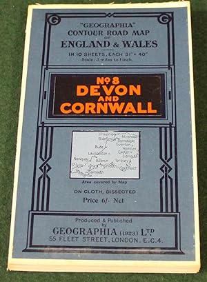
"Geographia" 10 Sheet Contour Road Map of England. Sheet 8, Devon & Cornwall. Scale 3 miles to 1 inch.
Published by London: Geographia Ltd. circa, 1920
Seller: Bristow & Garland, Shaftesbury, United Kingdom
Seller rating 4 out of 5 stars

US$ 20.69
US$ 18.75 shipping
Ships from United Kingdom to U.S.A.Quantity: 1 available
Add to basketColoured folding map dissected and mounted on linen, 31 x 40 inches, folding within the printed card covers; very good indeed.
-
The R.A.C. Country Road Map and Gazetteer; Devon and Cornwall Number 9
Language: English
Published by Ed J Burrow & Co, London
Seller: Balfour Books, Sidmouth, DEVON, United Kingdom
Seller rating 4 out of 5 stars
US$ 20.69
US$ 39.70 shipping
Ships from United Kingdom to U.S.A.Quantity: 1 available
Add to basketPaperback. Condition: Fair. No Jacket. Second Edition. Fair Copy in illustrated card wraps. Spine is split and wraps have become detached from contents. Outers a little grubby and chipped and creased around edges. Page corners creased down at upper and lower corners. Adverts as front and rear end papers. Previous owners ink notes on maps of Cornwall. Maps of Devon and Cornwall in centre of book, one section in middle detached and laid in, Clean text and colour maps.
-
Paperback. Condition: new. New Copy. Customer Service Guaranteed.
-
Bartholomew's 4 Miles to the Inch Road Map of England & Wales from the Ordnance Survey in Twelve Sheets Mounted on Cloth Sheet 10 Devon and Cornwall
Published by John Bartholomew & Co, The Edinburgh Geographical Institute, Edinburgh
US$ 55.17
US$ 33.48 shipping
Ships from United Kingdom to U.S.A.Quantity: 1 available
Add to basketSoft cover. Condition: Good ++. No date but estimate pre-WWI.
-

1806 Original Antique Road Map of DEVON and CORNWALL by Laurie and Whittle (17)
Seller: Antique Paper Company, ASHFORD, KENT, United Kingdom
Seller rating 2 out of 5 stars

US$ 103.44
US$ 8.03 shipping
Ships from United Kingdom to U.S.A.Quantity: 1 available
Add to basketListing Template 2018 Home About Us View Feedback Contact Us 1806 Original Antique Road Map of DEVON CORNWALL by Laurie Whittle (17)Click image to enlargeDescription1806Completion of the Roads to the Lands End with Roads to Dartmouth, Plymouth, Fowey, Falmouth, Padstow, Biddeford and Barnstaple- ROADS MEASURED FROM HYDE PARK CORNERAn original antique map taken from Laurie Whittle's 'Travellers Companion' showing the areas from Exeter, Ashburton, Oakhampton, Kingsbridge, Plympton, Tavistock, Barnstaple, Hatherleigh, Launceston, Camelford, Leskard, Bodmin, Lestwithel, Fowey, Padstoe, Truro, Redruth, Penryn, Helstone, St Ives, Marazion Jew Market, Penzance, Trevescan, Lands Endetc.Overall size 263mmx 310mmand ready formountingand framing.CONDITION:Overall excellent condition with light ageing. Original outline bright hand colouring.Shipping View Our Categories Decorative Prints World Wide Maps Scotland Maps Architecture Design England Maps Royalty About UsWe specialise in selling all items that can be considered to be Antique Paper. * PRINTS * MAPS * HISTORICAL DOCUMENTS * POSTAL HISTORY * BOOKS * POSTERS * STAMPS * POSTCARDS * EPHEMERA And anything else that is considered Antique and made of Paper. ALL OF OUR ITEMS ARE ORIGINAL ANTIQUES - NOT MODERN COPIES. We are also very keen buyers of anything similar and especially after better collections, original archives, whole libraries and better single items and have and#163;250,000 in cash funds at anyone time to buy the right items. Contact UsIf you have any questions then please do not hesitate to contact us through the eBay messaging system. Feedback We will always help you to have a 100% positive happy buying experience. Contact us if you are unhappy about any aspect of your purchase from us. We only want five star feedback from you so buy with confidence.
-

c1675 Original Antique Map DEVON CORNWALL - Barnstable to Truro Ogilby ROAD MAP
Seller: Antique Paper Company, ASHFORD, KENT, United Kingdom
Seller rating 2 out of 5 stars
US$ 241.36
US$ 8.03 shipping
Ships from United Kingdom to U.S.A.Quantity: 1 available
Add to basket1675 The Continuation of ye Extended Road from Barnstable to Truro Plate ye 3d & last. Comenceing at Hatherley in Com. Devonshire & Extending to Truro in Commitatis Cornub This handsome road map is from John Ogilvy's Britannia, which was the first survey of the roads of England and Wales. It was also the first graphic delineation of roads which established the practice of representing the road on the continuous unfolding strip. Blank verso. Measures 470 x 380mm with early hand colouring. CONDITION: Original antique Map is in good condition with the usual central fold as issued. Lightly age toned. Will look wonderful once mounted and framed. ALL OF OUR MAPS & PRINTS ARE GUARANTEED ORIGINAL ANTIQUES. We do not sell reproductions.Exported By ExportYourStore.
-

c1675 Original Antique Map DEVON CORNWALL - Barnstable to Truro Ogilby ROAD MAP
Seller: Antique Paper Company, ASHFORD, KENT, United Kingdom
Seller rating 2 out of 5 stars
US$ 255.16
US$ 8.03 shipping
Ships from United Kingdom to U.S.A.Quantity: 1 available
Add to basketListing Template 2018 Home About Us View Feedback Contact Us c1675 Original Antique Map DEVON CORNWALL - Barnstable to Truro Ogilby ROAD MAPDescription1675 The Continuation of ye Extended Road from Barnstable to TruroPlate ye 3d last. Comenceing at Hatherley in Com. Devonshire Extending to Truro in Commitatis Cornub Thishandsome road mapisfrom John Ogilvy's Britannia, which was the first survey of the roads of England and Wales. It was also the first graphic delineation of roads which established the practice of representing the road on the continuous unfolding strip. Blank verso.Measures 470x 380mm with early hand colouring.CONDITION:Original antique Mapis in good condition with the usual central fold as issued. Lightly age toned. Will look wonderful once mounted and framed.ALL OF OUR MAPS PRINTS ARE GUARANTEED ORIGINAL ANTIQUES. We do not sell reproductions. View Our Categories Decorative Prints World Wide Maps Scotland Maps Architecture Design England Maps Royalty About UsWe specialise in selling all items that can be considered to be Antique Paper. * PRINTS * MAPS * HISTORICAL DOCUMENTS * POSTAL HISTORY * BOOKS * POSTERS * STAMPS * POSTCARDS * EPHEMERA And anything else that is considered Antique and made of Paper. ALL OF OUR ITEMS ARE ORIGINAL ANTIQUES - NOT MODERN COPIES. We are also very keen buyers of anything similar and especially after better collections, original archives, whole libraries and better single items and have and#163;250,000 in cash funds at anyone time to buy the right items. Contact UsIf you have any questions then please do not hesitate to contact us through the eBay messaging system. Feedback We will always help you to have a 100% positive happy buying experience. Contact us if you are unhappy about any aspect of your purchase from us. We only want five star feedback from you so buy with confidence.
