

Order Total (1 Item Items):
Shipping Destination:

Dieppe by Tassin (1 results)
Skip to main search results
Search filters
Product Type
- All Product Types
- Books (1)
- Magazines & Periodicals (No further results match this refinement)
- Comics (No further results match this refinement)
- Sheet Music (No further results match this refinement)
- Art, Prints & Posters (No further results match this refinement)
- Photographs (No further results match this refinement)
- Maps (No further results match this refinement)
- Manuscripts & Paper Collectibles (No further results match this refinement)
Condition Learn more
- New (No further results match this refinement)
- As New, Fine or Near Fine (No further results match this refinement)
- Very Good or Good (No further results match this refinement)
- Fair or Poor (No further results match this refinement)
- As Described (1)
Binding
- All Bindings
- Hardcover (No further results match this refinement)
- Softcover (No further results match this refinement)
Collectible Attributes
- First Edition (No further results match this refinement)
- Signed (No further results match this refinement)
- Dust Jacket (No further results match this refinement)
- Seller-Supplied Images (1)
- Not Print on Demand (1)
Language (1)
Price
- Any Price
- Under US$ 25 (No further results match this refinement)
- US$ 25 to US$ 50 (No further results match this refinement)
- Over US$ 50
Free Shipping
- Free Shipping to U.S.A. (No further results match this refinement)
Seller Location
Seller Rating
-
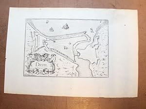
Dieppe.
Published by Sans nom ni date (circa 1631)., 1631
Gravure en noir, 240 x 165 mm, très bon état. Ce plan de Dieppe est tiré de l'ouvrage: Plans et profilz des principales villes de la province de Normandie. Christophe Tassin, commissaire ordinaire des guerres, viendra un temps à la librairie et à l'édition. Ingénieur géographe du roi en 1631, il obtient le privilège de dix ans de faire " imprimer, vendre et débiter par qui bon lui semblera les cartes générales et particulières de France et des Royaumes". En trois ans de 1633 à 1635, il fit paraître toute son oeuvre gravée puis vendit son privilège. Ses ouvrages sont des oeuvres de grande vulgarisation à l'usage des voyageurs et des militaires.
