
Order Total (1 Item Items):
Shipping Destination:

France by Thomas Ewing (4 results)
Skip to main search results
Search filters
Product Type
- All Product Types
- Books (3)
- Magazines & Periodicals (No further results match this refinement)
- Comics (No further results match this refinement)
- Sheet Music (No further results match this refinement)
- Art, Prints & Posters (No further results match this refinement)
- Photographs (No further results match this refinement)
- Maps (1)
- Manuscripts & Paper Collectibles (No further results match this refinement)
Condition Learn more
- New (2)
- As New, Fine or Near Fine (No further results match this refinement)
- Very Good or Good (No further results match this refinement)
- Fair or Poor (No further results match this refinement)
- As Described (2)
Binding
- All Bindings
- Hardcover (2)
- Softcover (No further results match this refinement)
Collectible Attributes
- First Edition (1)
- Signed (No further results match this refinement)
- Dust Jacket (No further results match this refinement)
- Seller-Supplied Images (2)
- Not Print on Demand (4)
Language (2)
Price
- Any Price
- Under US$ 25 (No further results match this refinement)
- US$ 25 to US$ 50
- Over US$ 50
Free Shipping
Seller Location
Seller Rating
-

HRD. Condition: New. New Book. Shipped from UK. Established seller since 2000.
-
A Record of the Families of Robert Patterson (the Elder), Emigrant From Ireland to America, 1774; Thomas Ewing, From Ireland, 1718; And Louis Du Bois, From France, 1660, Vol. 1: Connected by the Marriage of Uriah Du Bois With Martha Patterson, 1798
Seller: PBShop.store UK, Fairford, GLOS, United Kingdom
Seller rating 5 out of 5 stars

US$ 38.83
US$ 5.58 shipping
Ships from United Kingdom to U.S.A.Quantity: 15 available
Add to basketHRD. Condition: New. New Book. Shipped from UK. Established seller since 2000.
-

France
Published by circa 1850, 1850
Seller: Art Source International Inc., Boulder, CO, U.S.A.
Seller rating 5 out of 5 stars
This map comes from "Ewing's New General Atlas," published circa 1850. Maps by Thomas Ewing are difficult to find. With original outline watercolor and beautiful engraving, these maps would make a fine addition to any collection. This map measures 9 inches by 7 inches.
-
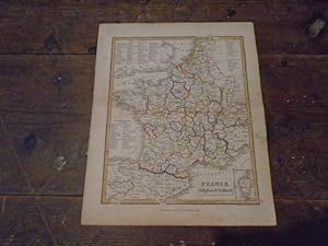
Map of France, Belgium and Holland from Ewing's New General Atlas
Published by Published by Oliver & Boyd, Edinburgh, 1845
Seller: Keoghs Books, Skipton, United Kingdom
Association Member: PBFA
Seller rating 5 out of 5 stars
Map First Edition
US$ 69.05
US$ 37.54 shipping
Ships from United Kingdom to U.S.A.Quantity: 1 available
Add to basket, colour outlined map from Ewing's New General Atlas featuring France, Belgium and Holland, with insert of Corsica, lists of French departments, Holland and Belguim provinces First Edition , folded across the middle, tanned around edges with pencil mark to one border, very good condition , 25 cm x 20 cm Map ISBN: