Hispania Nova Tabula (11 results)

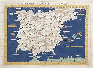
Published by 30 x 40 cm. Recto con hermoso frontispicio renacentista con texto explicativo: Hispania undique alluitur mariideo in numerum non uenit. Grabado perteneciente a la Cosmographiae universalis libri VI impresa en Basilea en 1.542.
- Softcover
Seller: MUNDUS LIBRI- ANA FORTES, Salamanca, SA, SpainMUNDUS LIBRI- ANA FORTES
Contact seller5-star sellerCondition: Used - Very good
US$ 885.45
US$ 131.81 shippingShips from Spain to U.S.A.Quantity: 1 available
Condition: Bueno. . . Cartela explicativa en margen inferior derecho. Carpeta en cartoné marrón. Buen ejemplar con pequeñas restauraciones de polilla. Español.
Published by Venezia, 1561
- Art Print
Seller: libreria antiquaria perini Sas di Perini, Verona, VR, Italylibreria antiquaria perini Sas di Perini
Contact seller5-star sellerCondition: Used
US$ 295.15
US$ 45.85 shippingShips from Italy to U.S.A.Quantity: 1 available
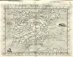
Incisione in rame, colorata a mano, di mm 190x263, tratta dall'edizione veneziana della "Geographia" curata da Ruscelli. Buon esemplare. Nr.cat: P4090019.

Published by Venezia 1574
- Map
Seller: Libreria Ex Libris ALAI-ILAB/LILA member, Roma, RM, ItalyLibreria Ex Libris ALAI-ILAB/LILA member
Contact seller5-star sellerCondition: Used
US$ 354.18
US$ 34.39 shippingShips from Italy to U.S.A.Quantity: 1 available
Incisione originale su rame (cm. 25x19,5 più margini bianchi) tratta da 'La Geografia di Claudio Tolomeo'. Margine laterale destro rifilato, ma ottimo esemplare.
Published by Ruscelli c. 1561, Venice 1561
- Map
Seller: Alexandre Antique Prints, Maps & Books, Toronto, ON, CanadaAlexandre Antique Prints, Maps & Books
Contact seller4-star sellerCondition: Used - Very good
US$ 375.00
US$ 6.00 shippingShips from Canada to U.S.A.Quantity: 1 available
Condition: Very Good. Italian text on verso.An early map of the Iberian Peninsula, including Spain and Portugal, beautifully hand coloured. Girolamo Ruscelli (1518?1566) was an Italian mathematician and cartographer active in Venice during the early 16th century. Ruscelli is best known for his important revision of Ptolemy's Geo…graphia, published posthumously in 1574., Size : 195x265 (mm), 7.68x10.43 (Inches), Hand Colored.
Published by Venecia 1599
- First Edition
- Art Print
Seller: Frame, Madrid, M, SpainFrame
Contact seller5-star sellerCondition: Used - Good
US$ 649.33
US$ 57.31 shippingShips from Spain to U.S.A.Quantity: 1 available
Condition: ACEPTABLE. [Un] Mapa, "Hispania nova tabvla. Della Spagna. Seconda nvova tavola d'Evropa.", parte de la Geografia di Claudio Tolomeo Alessandrino, nuouamente tradotta di Greco in Italiano, da Girolamo Ruscelli . In Venetia, Appresso Vincenzo Valgrisi, M.D.LXI. (1561).", en "Descrittione della Spagna" de Claudius Ptolo…meo. Claudio Ptolomeo (87-150) era un astrónomo y geógrafo egipcio que vivió y estudio en Alejandría. Alejandría no sólo era el hogar de la mayor biblioteca del mundo de todas las epocas, sino que era también uno de los centros comerciales más importantes entre el oeste y el este. Aquí Ptolomeo no sólo podía estudiar las autoridades antiguas, sino también consultar a viajeros y comerciantes contemporáneos. De esta riqueza de conocimientos acumulados, Ptolomeo compuso su Geographia, una obra de considerable genio, que dominó todo el mundo cristiano y musulmán durante 1.500 años. Fue Ptolomeo quien introdujo el concepto de latitud y longitud para formar una cuadrícula que cubriera el mundo entero, de modo que sería posible trazar la posición de las marcas principales en el mapa mediante observaciones. Por desgracia, Ptolomeo se vio obstaculizado por la escasez de observaciones -como resultado exageró la extensión del Mediterráneo en más de 20 grados- A pesar de estos errores, el trabajo fue de fundamental importancia en un momento en que poco se estaba haciendo en el camino de la cartografía moderna y perduró durante los siguientes 1500 años. Ptolomeo se ha ganado la reputación y el elogio como el padre de la geografía. En 1477, se publicó en Bolonia la primera edición impresa de la Geografía de Ptolomeo con mapas. El gran número de ediciones del atlas ptolemaico incluso hasta impresiones tan tarde como 1840, son testimonio de la influencia de Ptolomeo y la popularidad de sus mapas clásicos en las que publicaban los mapas basados casi exclusivamente en su detalle del mundo antiguo. Aunque el contenido cartográfico de los atlas y mapas ptolemaicos era estándar, ciertas ediciones son dignas de comentario: -1477la primera edición con mapas. Bologna. Grabados de planchas cobre. -1482Ulm Ptolomeo. (Primer mapa moderno de España/ mismo año que la edición de Florencia). -1482Florencia, Berlinghieri (contiene el primer mapa moderno de España). -1511Edición por Sylvanus en Venecia.(27 mapas antiguos y uno moderno del mundo) -1513Publicado por Martin Waldseemuller, incorporando 20 nuevos mapas, incluyendo el segundo mapa para centrarse en los descubrimientos del Nuevo Mundo. Posiblemente el Atlas mas importante de Ptolomeo. Famosa mención del Mapa del Admiral (C. Colon), Xilografías. Segunda impresión idéntica en 1520. (27 mapas + 20 modernos). Reverso de los mapas en blanco en las dos ediciones. -1522Ilustrado con xilografías grabados por Laurent Fries, cuidadosa reducción de los mapas de Waldseemuller. Segunda edición de 1525 también en Estrasburgo. Se comenta que el reverso de los mapas podría haber sido grabada por A. Durero. -1535 y 1541Reedición con textos nuevos editados por M. Servet.(basado en los de Pirckheimer). Reverso grabado por Holbein. Se diceque ha Servet se le quemó en la hoguera junto a sus libros "controvertidos". 1540-Mapas de Ptolomeo de Sebastian Munster; posteriormente reeditado en una variedad de libros de geografía clásica. 1548-La primera edición en italiano, la primera en miniatura, en cobre, de la geografía de Ptolomeo, que incluye varios mapas nuevos de Gastaldi. 1561- Los mapas de Gastaldi volvieron a publicarse, en un formato un poco más grande, por Ruscelli y Valgrisi en Venecia. 1578-el primer atlas de Mercator con los mapas de Ptolomeo - pretende ser un compañero de su Atlas del Mundo Moderno. Formato (cm): 22,5x32.

Published by Artist: Ruscelli Girolamo ( - 1566 ) Venice ca : 1564 1518
Seller: Antique Sommer& Sapunaru KG, München, , GermanyAntique Sommer& Sapunaru KG
Contact seller4-star sellerCondition: Used
US$ 708.36
US$ 51.58 shippingShips from Germany to U.S.A.Quantity: 1 available
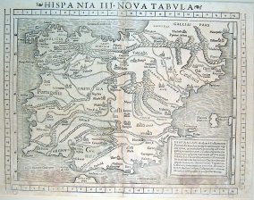
Technic: Copper print, colorit: original colored, condition: Perfect condition, size (in cm): 19 x 25 cm, Map shows the Iberian Peninsula with Spain, Portugal and the Balearic Islands.

Published by Heinrich Petri, Basel 1542
Seller: Librería José Porrúa Turanzas S.A., Madrid, M, SpainLibrería José Porrúa Turanzas S.A.
Contact seller5-star sellerCondition: Used
US$ 1,652.83
US$ 32.09 shippingShips from Spain to U.S.A.Quantity: 1 available
Basel, Heinrich Petri, 1542. (283 x 370)mm. Mapa montado sobre dos hojas coloreado a mano de época. Segunda edición del mapa de España de la Geographia Universalis del cartógrafo alemán Sebastian Münster, la primera impresa en 1540. El mapa está coloreado a mano en la época y representa la Península Ibérica con sus poblaciones m…ás importantes y los accidentes geográficos. 283x370mm. (11¼x14½").
Published by Venezia 1598
- Art Print
Seller: libreria antiquaria perini Sas di Perini, Verona, VR, Italylibreria antiquaria perini Sas di Perini
Contact seller5-star sellerCondition: Used
US$ 1,062.53
US$ 45.85 shippingShips from Italy to U.S.A.Quantity: 1 available
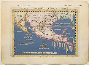
Incisione in rame, dipinta a mano, mm 187x255. Buon esemplare. Tratta dallíedizione della ìGeografiaî di Tolomeo, curata da Moleto e pubblicata dagli eredi Sessa, terza edizione nella traduzione di Ruscelli. La carta Ë basata su quella di Gastaldi del 1548 pubblicata nella sua edizione della ìGeografiaî che fu una delle due prim…e carte regionali del nord America (insieme a Tierra Nueva Tabula). Questa terza edizione, 3? Stato, risulta la pi? rara fra i tre stati, Ë significativamente rielaborata e include numerosi abbellimenti e aggiunte di toponimi e una topografia rivisitata, fra cui molte isole nuove. Come elemento decorativo una nave nel Mare Pacificum. Vengono aggiunte nuove etichette, tra cui Calmifor (California), Sierra Nevad (Sierra Nevada) e Golfo Mexicano (Golfo del Messico). Questa Ë forse la mappa pi? influente del Sud-Ovest durante il XVI secolo. » anche una delle prime mappe della regione e rappresenta un importante contributo alla conoscenza della geografia della Nuova Spagna. Bellíesemplare, minimo strappetto di un centimetro al margine destro. Girolamo Ruscelli (1500-1566) nasce a Viterbo ed Ë un importante scrittore ed editore, che dopo aver studiato a Padova trascorse la propria carriera fra Roma e Napoli, dove morÏ. Burden 31. Nr.cat: Cod 3090.
Condition: Used - Good
US$ 1,800.41
US$ 57.31 shippingShips from Spain to U.S.A.Quantity: 1 available
Condition: ACEPTABLE. Hispaniam divident a Gallia montes Pyrenaei. Et hinc erumput ramenta perregi.copiosius dicerut Mapa realizado por Sebastian Munster, publicado en la Geografía de Ptolomeo Formato (cm): 40x30.

Published by Girolamo Ruscelli 1561
- Map
Seller: Antiquariaat Dat Narrenschip, Middelburg, NetherlandsAntiquariaat Dat Narrenschip
Contact seller5-star sellerCondition: Used - Fine
US$ 259.73
US$ 30.95 shippingShips from Netherlands to U.S.A.Quantity: 1 available
No Binding. Condition: Fine. Antique map of Spain and Portugal. Backside Italian text. Copper engraving, published in Venice in 1561 by Vincenzo Valgrisi in Girolamo Ruscelli's "La Geografia. nuovamente tradotta di Greco in Italiano, da Girolamo Ruscelli." Dimensions (image): 19 x 25 cm.

- Map
Seller: Altea Antique Maps, London, , United KingdomAltea Antique Maps
Contact seller5-star sellerCondition: Used
US$ 353.68
US$ 46.22 shippingShips from United Kingdom to U.S.A.Quantity: 1 available
Venice: Vincenzo Valgrisi, c.1561, First State. 200 x 260mm. A 'modern' map of Spain, including the Balearics, published in Ruscelli's 'La Geographi di Claudio Tolomeo'. A feature of this first state is that there is no platemark at the top: two maps were engraved on the same plate and the resulting sheet halved. Later the plate… was cut in two.


