Historical Map: Signed (19 results)

Language: English
Published by Mantle 2024
Series: The Joubert Family Chronicles, Book 4 of 4. Book 4 of 4 - The Joubert Family Chronicles
- Hardcover
- First Edition
- Signed
Seller: Book_Attic, Newark on Trent, , United KingdomBook_Attic
Contact seller5-star sellerCondition: New
US$ 34.11
US$ 29.34 shippingShips from United Kingdom to U.S.A.Quantity: 1 available
Hardcover. Condition: New. Dust Jacket Condition: New. 1st Edition. Mantle; 2024. First edition. SIGNED by author. Brand new book. Signed by Author(s).

Published by The Norman, Remington Company
- Hardcover
- First Edition
- Signed
Seller: Wonder Book, Frederick, MD, U.S.A.Wonder Book
Contact seller5-star sellerCondition: Fair. Signed Copy First edition copy. . Inscribed by author on front endpage. Signed handwritten letter by author laid in. Front hinge split. (Maryland, Church of England, history).
 More images
Published by Reclus
- Signed
- Art Print
Seller: Artisans-lane Maps & Prints, Sidney, BC, CanadaArtisans-lane Maps & Prints
Contact seller4-star sellerCondition: Used - Very good
US$ 14.55
US$ 19.00 shippingShips from Canada to U.S.A.Quantity: 1 available
no binding. Condition: very good. The first railway built in Africa was in Egypt in 1853. The idea of building a railway goes back to 1833 when Mohamed Ali consulted his Scottish chief Engineer, T. Gallway, about building a route between Suez and Ain Shames to become the link between Europe and India. Mohamed Ali started initiat…ing the project as he bought the rails in order to start building the route and the stations. However, France was able to prevent this from happening because the French government wanted to substitute this project with building a canal between the Red and the Mediterranean Seas. Mohamed Ali found himself shattered between the two ideas, so he refused to carry out any of them. When Mohamed Ali died in 1849, England wrote to his successor, Abass Helmy I, asking him to build a railway in Egypt. He agreed and he signed a contract with Robert Stephenson, on the 12th of June, 1851. The contract asserted that the work should start in September of the same year and that Stephenson should be responsible for all the matters of the project. The first railway route in Egypt was built in 1854, between Alexandria and Kafer Eassa, and it reached Cairo in 1856. In 1858, the route between Cairo and Suez was built, but it was taken off in the year 1878 after digging the Suez Canal. A new route was built in 1867 to connect Cairo with southern Egypt and Imbaba Bridge was built in 1891 to enable the trains to pass over the Nile near Cairo. And from this point on, the railway has become one of the most important means of transportation in Egypt. You can use the railway to go as far as Matrouh in the west and as far as Aswan in the north. Passengers can depend on the railway service to travel all over Egypt. PRINT INDENTIFIES THE RAILWAYS, ABANDONED LINES, AND THE TELEGRAPH LINES BEYOND THE THE RAILWAY SYSTEM. Overall Size including borders : 10 1/2 x 7 Ins . CONDITION: Clear and sharp with beautiful detail. As scanned. These beautiful prints would look great matted and framed. Or an art supply store can provide you with a selection of frames for old art treasures. NOTE THE FOLLOWING BEFORE YOU PURCHASE: This is a GENUINE ANTIQUE VINTAGE 1880s PRINT. It is NOT a modern reproduction, ie. a laser scan, photocopy etc. It is the original from the antique or vintage atlas or book publication. This print was published on the date mentioned, or circa of the date mentioned at the top of the page. The print I have for sale, like many antique vintage prints and maps that you see online, originate from an antique vintage book or atlas publication. The publication may not always be known. If you have any questions, emails are welcome.
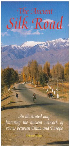
Language: English
Published by Odyssey Publications; Airphoto International Ltd., Hong Kong * * * * * 2007
- Softcover
- Signed
- Map
Seller: L. Michael, North Hollywood, CA, U.S.A.L. Michael
Contact seller4-star sellerCondition: Used - Fine
US$ 315.20
US$ 15.26 shippingShips within U.S.A.Quantity: 1 available
Soft cover. Condition: Fine. Map: Fine/, $589.80, Reduced From. 9789622177888 the ANCIENT SILK ROAD MAP: an Illustrated Map Featuring the Ancient Network of Routes Between CHINA and EUROPE; One large overview map and three detailed regional maps. Comprehensive notes with cultural and Historical information on key places and peop…le, 35 superb colour photographs, easy~to~use fold~out format. ONLINE Synopsis: Made famous in the West by the Venetian adventurer, Marco Polo, the ancient Silk Road spanned one-quarter of the circumference of the Earth. An intricate network of trading routes, in its heyday it stretched from Lyoyang and Xi'an in China, through Central Asia to Istanbul and Rome, perhaps the first example of the globalisation of trade. Untold perils, both natural and man-made, awaited the hardy merchants and travellers who ventured along the Silk Road's many branches in search of profit, learning or simply adventure. Conquering armies, too, swept back and forth throughout the centuries of the Road's existence. All have left their mark in some way. Inside are four detailed maps of the Silk Road's arteries supplemented by 35 colour photographs and historical notes on key places and notable people.* TUCKER, Jonathan; TOZER, Antonia Odyssey Publications; Airphoto International Ltd. 2007 Hong Kong * * * * * UnStated Edition Tall Wide Folding Map S/c Soft Cover Map: Fine/, Slight, Shelf, Edge And Corner Wear. Pages Printed On 0ff~White Paper, Clean And Tight To The Spine, In Fine/ Condition. Appear To Be Viewed. D/j: None. This Item Will Be Sent Wrapped In Plastic, Taped Shut And In A = Padded Mailing Envelope To Prevent Shipping Damage So That It Will Arrive In The Description Described Which Applies To This B00K, Only. = No Odors, No Writing, No Names, No Rippling, Not Stuck Together, No Book Plate, Not X~Library, No Other Marks. = Will Make It, An Excellent Addition To Your Own Personal Library Collection, Or As A Gift, For The Discriminating Reader / Collector. = WORLD WIDE SHIPPING, AVAILABLE *. Map: Fine/, 2007 (illustrator). Signed by Author(s).
 More images
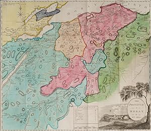
A Survey of the Province of Moray; Historical, Geographical, and Political. [Inscribed and dedicated by scottish Mapmaker William Millar / Including the amazing, large Map of Moray and the Nairn Shires by William Millar (51 cm x 49 cm) and the engraving of "Elgin Cathedral" (also by William Millar)]
Handcoloured Map Art of 18th century Scotland - [Millar, William] / [Grant, John] / [Leslie, William] Forsyth, Isaac / [Hugh Houstoun]
Language: English
Published by Aberdeen, Printed for Isaac Forsyth, Bookseller, Elgin 1798
- Hardcover
- First Edition
- Signed
Seller: Inanna Rare Books Ltd., Skibbereen, CORK, IrelandInanna Rare Books Ltd.
Contact seller5-star sellerCondition: Used - As new
US$ 1,176.94
US$ 31.99 shippingShips from Ireland to U.S.A.Quantity: 1 available
Condition: Wie neu. First Edition. Octavo (14 cm x 21,5 cm). Folded, hand-coloured Frontispiece-Map by William Millar, Frotispiece-Engraving of the "Elgin Cathedral" , VIII, 353 pages. Original Hardcover / Original 18th or early 19th century leather with original spinelabel. The large, hand-coloured Map with a minor tear only. C…orners slightly bumped. Spine slightly starting but overall in excellent condition with some minor signs of wear only. Interesting Provenance and signed manuscript dedication by the Cartographer and Mapmaker William Millar: From the library of Aberdeen Highlander, Major Hugh Houstoun, with a dedication: "April 27th, 1798 - To Major Hugh Houstoun - from his Much obliged and Humble Servant William Millar". The fantastic Map in this publication was produced by William Millar, who is identified inside the publication in the text of an Advertisement, placed verso the titlepage and in which the Publisher Isaac Forsyth of Aberdeen gives thanks: ".For the very handsome manner in which the two first chapters were furnished by the Revd. Mr.Grant of Elgin and the other two by the Revd. Mr.Leslie of Darkland, he offers this testimony of his grateful remembrance. Nor can he omit expressing his sense of obligation to Mr.William Millar, Engineer of the Sutherland Coal Work, for the Most accurate Map of the Province of Moray ever offered to public notice." The publication includes for example stories about the "First Inhabitants (Celts, Picts, Scots), Surnames in Moray, Thanes, Earls of Moray, Family of Gordon, Family of Grant, Family of Shewglie, Family of Innes, Family of Brodie, Family of Calder, Family of Kilravock, Family of Dunbars, Family of Grangehill and Durn, Family of Comyn of Altre, Family of Fraser of Lovat, Family of Mackintosh, Family of Macpherson, Family of Macdonalds of Glengary, Family of Duff (Earl of Fife), Family of Gordonstown, Family of Lethin, Family of Findrassie, Family of Murreffs of Duffus, Population of Moray, Antiquities of the Province with Roman Progress in Moray, Vitrified Forts, etc. etc.
 More images
Published by Blair & Rives, Washington, D.C. 1840
- Hardcover
- First Edition
- Signed
Seller: Long Brothers Fine & Rare Books, ABAA, Seattle, WA, U.S.A.Long Brothers Fine & Rare Books, ABAA
Contact seller3-star sellerCondition: Used - Very good
US$ 1,750.00
US$ 3.50 shippingShips within U.S.A.Quantity: 1 available
Hardcover. Condition: Very Good. First Edition. 8vo. Pp. xi, 228. Document 174. Published at the behest of the 26th Congress, 1st Session. Index Fold-out map. Original brown cloth, spine lettered in gilt, embossed design to boards. Ex-library, with usual markings, small tear to margin of map, scattered light foxing, chip to foot… of spine. Still tight. Inscribed by the author of front pastedown. The genesis for Greenhow's History of Oregon and California and the Other Territories on the North-West Coast of America, this report on the Northwest Coast was produced at the direction of Missouri Senator L. F. Linn, per his Select Committee on the Oregon Territory. According to Decker, in SOLIDAY, Greenhow relied heavily on Capt. Joseph Ingraham's Journal of the Brigantine "Hope", which provides a strong US-prejudice in the "Oregon Question." COWAN, p. 249; HOWES G389; SMITH, 3848. See TWENEY 89, Appendix B. COWAN, p. 249; HOWES G389; SMITH, 3848. See TWENEY 89, Appendix B.
 More images
Published by Franklin D. Richards; London: Latter-Day Saints Book Depot, Liverpool 1855
- Hardcover
- Signed
Seller: Donald A. Heald Rare Books (ABAA), New York, NY, U.S.A.Donald A. Heald Rare Books (ABAA)
Contact seller5-star sellerCondition: Used
US$ 14,500.00
US$ 25.00 shippingShips within U.S.A.Quantity: 1 available
4to. (12 x 9 1/2 inches). viii, 120 pp. Folding map, thirty engraved plates, and woodcuts in text illustrations after Frederick H. Piercy. Contemporary half calf and tan cloth covered boards, rebacked. Housed in a red morocco backed box. A landmark depiction of the West with superb plates, and one of the most important publicati…ons devoted to the Mormon emigration: with provenance to Brigham Young's daughter. "This elaborately prepared and illustrated book was published as a monument to the Mormon emigration to Utah, and as a means of attracting further emigrants. Piercy made a special trip to America [in 1853] to make sketches for the plates, which are some of the best western views of the period" (Streeter). The outstanding views show New Orleans, Natchez, Vicksburg, Nauvoo, Council Bluffs, Laramie, Fort Bridger, and Scott's Bluff. ".One of the most elaborately and beautifully illustrated of western books" (Howes). ".One of the basic sources of illustrated Western Americana of the period" (Taft). "One of the most illuminating maps of the West to appear during 1855.it shows Utah in all its glory. This is not only an important map in the history of Mormons, but is in every sense an important map in the history of the West, giving as it does a carefully drawn picture of that entire area" (Wheat). This copy inscribed by Brigham Young's daughter Maria Young Dougall (1849-1935) to her niece Leah Dunford Widstoe and her husband, John A. Widstoe (1872-1952), a member of the Quorum of the Twelve Apostles. It is additionally signed by prominent LDS Elder (and Maria Dougall's husband) William Bernard Dougall (1843-1909). Howes L359, "b;" Wagner-Camp 259; Graff 2501; Flake 6381; Sabin 41325; Streeter Sale 2296; Taft, Artists & Illustrators of the Old West, p.285; Wheat Transmississippi IV, pp.40-41; Crawley & Flake, A Mormon Fifty 46.
 More images
Published by Printed and Published by Abraham Small, Philadelphia 1819
- Hardcover
- Signed
Seller: The First Edition Rare Books, LLC, Cincinnati, OH, U.S.A.The First Edition Rare Books, LLC
Contact seller5-star sellerCondition: Used - Very good
US$ 6,800.00
US$ 6.00 shippingShips within U.S.A.Quantity: 1 available
Hardcover. Condition: Very good. First American Edition. Octavo, xx, [21] - 482pp. Half red morocco over marbled boards, title in gilt on spine, decorative gilt over 5 raised bands. Marbled endpapers, bookplate from "Geo. S. Perry, Cadiz, Ohio" affixed to front endpaper. Bumped corners, worn edges, marbled boards with shelf wear… and rubbing. Includes two foldout maps, one of the American continent and the second a hand-colored illustration of the topography of South America, with some splitting at seams of the first map. Marginal tear to front free endpaper [Aa] and dampstaining to lower margin, not affecting text. (Sabin 6333) Signed by Oliver Hazard Perry on front free endpaper, with the following inscription: "Com'o. O.H. Perry / US Ship John Adams." Additional signature by his wife (Elizabeth Champlin Mason Perry) below the signature: "Mrs. E.C. Perry / Feb'y 1845 / Brooklyn." Provenance: Book was passed down through the Perry family. Sold at Sotheby's, 2018. In 1818, the Perry-Elliott affair came to a head when Perry wrote to Navy Secretary Benjamin Crowninshield preferring court-martial charges against his former subordinate. Not wishing to expose the nation to the controversial aspect of Perry's splendid victory on Lake Erie, President James Monroe offered the prestigious title of "Commodore" to Oliver if he'd drop the charges against Elliott. Upon accepting that offer in early 1819 Perry set sail for the Orinoco River, Venezuela, aboard the frigate John Adams (carrying this very book with him) accompanied by the schooner Nonsuch, there to discourage piracy, while maintaining friendly diplomatic relations with the Republic of Venezuela and the Republic of Buenos Aires. Shifting his flag to the shallow-draft Nonsuch Perry sailed upriver to Angostura to negotiate an anti-piracy agreement with President Simon Bolivar. A favorable treaty was signed on August 11 with Vice-President Francisco Antonio Zea in the absence of Bolivar (who was engaged in the liberation of New Granada), but when the schooner started downriver, many of her crew, including Perry, had been stricken with yellow fever. Despite the crew's efforts to reach Trinidad for medical assistance, the commodore died on board Nonsuch on August 23, 1819, his 34th birthday, as the ship was nearing Port of Spain, his flagship John Adams in sight. He was buried in Port of Spain with great honors while the Nonsuch's crew acted as honor guard. Perry's remains were taken back to the United States in 1826 and interred in Newport, Rhode Island. Originally interred in the Old Common Burial Ground, his body was eventually moved to Newport's Island Cemetery. The first American edition of Spanish America, from the personal library of Commodore Oliver Hazard Perry, inscribed by him enroute to South America aboard the U.S.S. John Adams. (illustrator). Signed.
Published by Blair and Rives, Washington, D.C. 1840
- Hardcover
- First Edition
- Signed
Seller: RareNonFiction, IOBA, Ladysmith, BC, CanadaRareNonFiction, IOBA
Contact seller5-star sellerCondition: Used - Fair
US$ 2,950.00
US$ 19.99 shippingShips from Canada to U.S.A.Quantity: 1 available
Hardcover. Condition: Fair. First Edition. xi, 227 pages. Index. Fold-out map. Signed and inscribed by author to renowned historian William Hickling Prescott inside front board. Upon front free endpaper a subsequent owner (late 1800s) has documented the provenance of this copy and documented Prescott's pencil markings to pages 2…3 through 27 which deal with Cortes and Mexico. Occasional light markings to contents. Prior owner's mini-bookplate inside front board. Narrow openings along both hinges. Usual library markings. Fold-out map bears several short openings and a tape repair along right edge. Front free endpaper loose but present. Prior owner's signature atop title page. Above-average external wear to brown marbled boards. WHALE 508, TPL 2369, HOWES G-389, RICKS P.112, TOURVILLE 1850, SMITH 3848, WICKERSHAM 4086. Burr, David H. (cartographer) (illustrator). Signed by Author(s).
 More images
Published by Philadelphia 1823
- First Edition
- Signed
Seller: Antipodean Books, Maps & Prints, ABAA, Garrison, NY, U.S.A.Antipodean Books, Maps & Prints, ABAA
Contact seller4-star sellerCondition: Used - Very good
US$ 275.00
US$ 10.00 shippingShips within U.S.A.Quantity: 1 available
Map. Condition: Very good condition. Fine original hand colored map of the British Empire in Canada, from the first edition of Carey and Lea's 'A Complete Historical, Chronological, and Geographical American Atlas, being a Guide to the History of North and South America, and the West Indies . to the Year 1822', the best atlas of… nineteenth century America. The map extends from Newfoundland in the east to Lake of the Woods in the west; a very vibrant, strong impression. The text describes Lower Canada, Upper Canada, Nova Scotia and New Brunswick. With text below map and at both sides, pertaining to topography, climate, lands, towns, roads and canals, education, government and history. This map, according to History Detectives (Season 6, Episode 4: Lincoln Forgery) was evidently part of an Abraham Lincoln memorabilia scam in which a forger named Harry Sickles worked with Eugene Field II to pass off items in Field's collection as Lincoln items. Sickles and Field managed to convince William P. Brown, the still living coachman of Abraham Lincoln, that they wanted his signature on the verso of their items. Brown's signature, and the notary's signature are genuine; the text referring to the map being given by Mrs. Lincoln to Brown in 1866 was added by the forger. This is the handwritten note on the verso: "This is from the collection of old books, papers, maps, etc presented to her coachman, Wm. P Brown, by Mrs. Lincoln in 1866. (Signed) Wm P Brown. The signatures are genuine. (Signed) Frank E. Thatcher". There is a blue notary stamp, (Muskegon County, Mich. 1933) and a circular blind stamp. Howe's C133. Image size: 20 3/4 x 16 1/2" on paper 22 1/4 x 17 1/2".
 More images
Published by Philadelphia 1823
- First Edition
- Signed
Seller: Antipodean Books, Maps & Prints, ABAA, Garrison, NY, U.S.A.Antipodean Books, Maps & Prints, ABAA
Contact seller4-star sellerCondition: Used - Very good
US$ 330.00
US$ 10.00 shippingShips within U.S.A.Quantity: 1 available
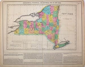
Map. Condition: Very good condition. Fine original hand colored map of New York from the first edition of Carey and Lea's 'A Complete Historical, Chronological, and Geographical American Atlas, being a Guide to the History of North and South America, and the West Indies to the Year 1822', the best atlas of 19th century America.…This map was made during the construction of the Erie Canal, which had such an enormous impact on transportation, commerce and the role of New York City as the major US port; it is named here the Grand Canal. With a table at the base of the map titled "Profile of Levels of the Grand Canal", showing the change in levels of the Erie Canal from Lake Erie to the Hudson River. With text below map and at both sides, pertaining to topography, climate, lands, towns, roads and canals, education, government and history. This particular copy of the map has an interesting Lincoln forgery connection. According to History Detectives (Season 6, Episode 4: Lincoln Forgery) was evidently part of an Abraham Lincoln memorabilia scam in which a forger named Harry Sickles worked with Eugene Field II to pass off items in Field's collection as Lincoln items. Sickles and Field managed to convince William P. Brown, the still-living coachman of Abraham Lincoln, that they wanted his signature on the verso of their items. Brown's signature, and the notary's signature are genuine; the text referring to the map being given by Mrs. Lincoln to Brown in 1866 was added by the forger. This is the handwritten note on the verso: "This is from the collection of old books, papers, maps, etc presented to her coachman, Wm. P Brown, by Mrs. Lincoln in 1866. (Signed) Wm P Brown. The signatures are genuine. (Signed) Frank E. Thatcher". There is a blue notary stamp, (Muskegon County, Mich. 1933) and a circular blind stamp. Howes C133. Image size: 20 3/4 x 16 1/2" on paper 22 1/4 x 17 1/2".
 More images
Published by Philadelphia 1823
- First Edition
- Signed
Seller: Antipodean Books, Maps & Prints, ABAA, Garrison, NY, U.S.A.Antipodean Books, Maps & Prints, ABAA
Contact seller4-star sellerCondition: Used - Very good
US$ 330.00
US$ 10.00 shippingShips within U.S.A.Quantity: 1 available
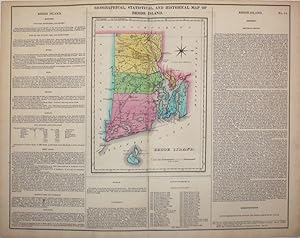
Map. Condition: Very good condition. Fine original hand colored map of Rhode Island from the first edition of Carey and Lea's 'A Complete Historical, Chronological, and Geographical American Atlas, being a Guide to the History of North and South America, and the West Indies . to the Year 1822', the best atlas of nineteenth centu…ry America. By the 1820's Rhode Island was one of the most industrialized states; the text notes that there were more than 90 cotton mills established. Brown University is noted under 'Education': [It] is one of the most flourishing and respectable literary institutions . in 1819 there were 126 students." With text below map and at both sides, pertaining to topography, climate, lands, towns, roads and canals, education, government and history. This map, according to History Detectives (Season 6, Episode 4: Lincoln Forgery) was evidently part of an Abraham Lincoln memorabilia scam in which a forger named Harry Sickles worked with Eugene Field II to pass off items in Field's collection as Lincoln items. Sickles and Field managed to convince William P. Brown, the still living coachman of Abraham Lincoln, that they wanted his signature on the verso of their items. Brown's signature, and the notary's signature are genuine; the text referring to the map being given by Mrs. Lincoln to Brown in 1866 was added by the forger. This is the handwritten note on the verso: "This is from the collection of old books, papers, maps, etc presented to her coachman, Wm. P Brown, by Mrs. Lincoln in 1866. (Signed) Wm P Brown. The signatures are genuine. (Signed) Frank E. Thatcher". There is a blue notary stamp, (Muskegon County, Mich. 1933) and a circular blind stamp. Howe's C133. Image size: 20 3/4 x 16 1/2" on paper 22 1/4 x 17 1/2".
 More images
Published by Philadelphia 1823
- First Edition
- Signed
Seller: Antipodean Books, Maps & Prints, ABAA, Garrison, NY, U.S.A.Antipodean Books, Maps & Prints, ABAA
Contact seller4-star sellerCondition: Used - Very good
US$ 330.00
US$ 10.00 shippingShips within U.S.A.Quantity: 1 available
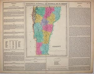
Map. Condition: Very good condition. Fine original hand colored map of Vermont from the first edition of Carey and Lea's 'A Complete Historical, Chronological, and Geographical American Atlas, being a Guide to the History of North and South America, and the West Indies . to the Year 1822', the best atlas of nineteenth century Am…erica. Published just 10 years after the War of 1812, the map references the war: "During the last war with England, the vicinity of the state was the seat of a warm contest. On the invasion of New York, volunteers poured forth from the mountains and vallies (sic) of Vermont." With text below map and at both sides, pertaining to topography, climate, lands, towns, roads and canals, education, government and history. This map, according to History Detectives (Season 6, Episode 4: Lincoln Forgery) was evidently part of an Abraham Lincoln memorabilia scam in which a forger named Harry Sickles worked with Eugene Field II to pass off items in Field's collection as Lincoln items. Sickles and Field managed to convince William P. Brown, the still living coachman of Abraham Lincoln, that they wanted his signature on the verso of their items. Brown's signature, and the notary's signature are genuine; the text referring to the map being given by Mrs. Lincoln to Brown in 1866 was added by the forger. This is the handwritten note on the verso: "This is from the collection of old books, papers, maps, etc presented to her coachman, Wm. P Brown, by Mrs. Lincoln in 1866. (Signed) Wm P Brown. The signatures are genuine. (Signed) Frank E. Thatcher". There is a blue notary stamp, (Muskegon County, Mich. 1933) and a circular blind stamp. Howe's C133. Image size: 20 3/4 x 16 1/2" on paper 22 1/4 x 17 1/2".
 More images
Published by Philadelphia 1823
- First Edition
- Signed
Seller: Antipodean Books, Maps & Prints, ABAA, Garrison, NY, U.S.A.Antipodean Books, Maps & Prints, ABAA
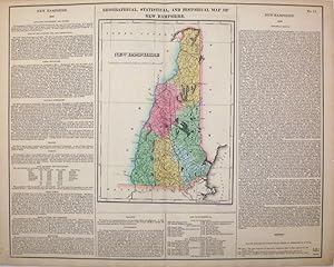
Contact seller4-star sellerCondition: Very good overall. Fine original hand colored map of New Hampshire from the first edition of Carey and Lea's 'A Complete Historical, Chronological, and Geographical American Atlas, being a Guide to the History of North and South America, and the West Indies . to the Year 1822', the best atlas of nineteenth century Ame…rica. Under 'Education' the text notes: Phillips' s Exeter academy . is one of the oldest and most flourishing academies in New England." With text below map and at both sides, pertaining to topography, climate, lands, towns, roads and canals, education, government and history. This map, according to History Detectives (Season 6, Episode 4: Lincoln Forgery.
 More images
Published by Philadelphia 1823
- First Edition
- Signed
Seller: Antipodean Books, Maps & Prints, ABAA, Garrison, NY, U.S.A.Antipodean Books, Maps & Prints, ABAA
Contact seller4-star sellerCondition: Used - Very good
US$ 413.00
US$ 10.00 shippingShips within U.S.A.Quantity: 1 available
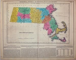
Map. Condition: Very good condition. Fine original hand colored map of Massachusetts from the first edition of Carey and Lea's 'A Complete Historical, Chronological, and Geographical American Atlas, being a Guide to the History of North and South America, and the West Indies . to the Year 1822', the best atlas of nineteenth cent…ury America. With a long text description titled 'Peninsulas, Islands and Capes' describing Cape Cod, Cape Anne, Martha's Vineyard, Nantucket, and the Elizabeth Islands. With text below map and at both sides, pertaining to topography, climate, lands, towns, roads and canals, education, government and history. This map, according to History Detectives (Season 6, Episode 4: Lincoln Forgery) was evidently part of an Abraham Lincoln memorabilia scam in which a forger named Harry Sickles worked with Eugene Field II to pass off items in Field's collection as Lincoln items. Sickles and Field managed to convince William P. Brown, the still living coachman of Abraham Lincoln, that they wanted his signature on the verso of their items. Brown's signature, and the notary's signature are genuine; the text referring to the map being given by Mrs. Lincoln to Brown in 1866 was added by the forger. This is the handwritten note on the verso: "This is from the collection of old books, papers, maps, etc presented to her coachman, Wm. P Brown, by Mrs. Lincoln in 1866. (Signed) Wm P Brown. The signatures are genuine. (Signed) Frank E. Thatcher". There is a blue notary stamp, (Muskegon County, Mich. 1933) and a circular blind stamp. Howe's C133. Image size: 20 3/4 x 16 1/2" on paper 22 1/4 x 17 1/2".
 More images
Published by Philadelphia 1823
- First Edition
- Signed
Seller: Antipodean Books, Maps & Prints, ABAA, Garrison, NY, U.S.A.Antipodean Books, Maps & Prints, ABAA
Contact seller4-star sellerCondition: Used - Very good
US$ 440.00
US$ 10.00 shippingShips within U.S.A.Quantity: 1 available
Map. Condition: Very good condition. Fine original hand colored map of Ohio from the first edition of Carey and Lea's 'A Complete Historical, Chronological, and Geographical American Atlas, being a Guide to the History of North and South America, and the West Indies . to the Year 1822', the best atlas of nineteenth century Ameri…ca. With many counties shown, and a reference to the suffering of the citizens of Ohio in the War of 1812, in which Perry defeated the British at Lake Erie, and famously declared "We have met the enemy and they are ours". This battle, fought only 10 years prior to the making of the map, gave the United States control over Lake Erie; the forts are named here. With text on two sides and below map, pertaining to topography, climate, lands, towns & ports, government and history. This map, according to History Detectives (Season 6, Episode 4: Lincoln Forgery) was evidently part of an Abraham Lincoln memorabilia scam in which a forger named Harry Sickles worked with Eugene Field II to pass off items in Field's collection as Lincoln items. Sickles and Field managed to convince William P. Brown, the still living coachman of Abraham Lincoln, that they wanted his signature on the verso of their items. Brown's signature, and the notary's signature are genuine; the text referring to the map being given by Mrs. Lincoln to Brown in 1866 was added by the forger. This is the handwritten note on the verso: "This is from the collection of old books, papers, maps, etc presented to her coachman, Wm. P Brown, by Mrs. Lincoln in 1866. (Signed) Wm P Brown. The signatures are genuine. (Signed) Frank E. Thatcher". There is a blue notary stamp, (Muskegon County, Mich. 1933) and a circular blind stamp. Howe's C133. Image size: 20 3/4 x 16 1/2" on paper 22 1/4 x 17 1/2".
 More images
Published by Philadelphia 1823
- Signed
Seller: Antipodean Books, Maps & Prints, ABAA, Garrison, NY, U.S.A.Antipodean Books, Maps & Prints, ABAA
Contact seller4-star sellerCondition: Used - Very good
US$ 523.00
US$ 10.00 shippingShips within U.S.A.Quantity: 1 available
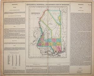
Condition: Very good condition. Fine original hand colored map of Mississippi from Carey and Lea's 'A Complete Historical, Chronological, and Geographical American Atlas, being a Guide to the History of North and South America, and the West Indies . to the Year 1822', the best atlas of nineteenth century America. With text on tw…o sides and below map, pertaining to topography, climate, lands, towns & rivers, 'Indian Country', public lands, roads & canals, government and history. This map, according to History Detectives (Season 6, Episode 4: Lincoln Forgery) was evidently part of an Abraham Lincoln memorabilia scam in which a forger named Harry Sickles worked with Eugene Field II to pass off items in Field's collection as Lincoln items. Sickles and Field managed to convince William P. Brown, the still living coachman of Abraham Lincoln, that they wanted his signature on the verso of their items. Brown's signature, and the notary's signature are genuine; the text referring to the map being given by Mrs. Lincoln to Brown in 1866 was added by the forger. This is the handwritten note on the verso: "This is from the collection of old books, papers, maps, etc presented to her coachman, Wm. P Brown, by Mrs. Lincoln in 1866. (Signed) Wm P Brown. The signatures are genuine. (Signed) Frank E. Thatcher". There is a blue notary stamp, (Muskegon County, Mich. 1933) and a circular blind stamp. Howes C133; Phillips 1373a; Wheat, Mapping of the Transmississippi West 2:81. Image size: 20 3/4 x 16 1/2" on paper 22 1/4 x 17 1/2".
 More images
Published by Carey & Lea, Philadelphia 1823
- First Edition
- Signed
Seller: Antipodean Books, Maps & Prints, ABAA, Garrison, NY, U.S.A.Antipodean Books, Maps & Prints, ABAA
Contact seller4-star sellerCondition: Used - Very good
US$ 550.00
US$ 10.00 shippingShips within U.S.A.Quantity: 1 available
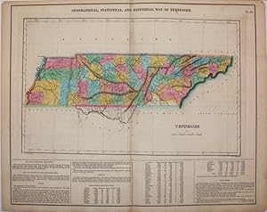
Map. Condition: Very good condition. First edition. Fine original hand colored map of Tennessee from the first edition of Carey and Lea's 'A Complete Historical, Chronological, and Geographical American Atlas, being a Guide to the History of North and South America, and the West Indies to the Year 1822', the best atlas of ninete…enth century America. Colors bright and fresh, great detail, a very vibrant, strong impression. With text below map and at both sides, pertaining to topography, climate, lands, towns, roads and canals, education, government and history. With a numerical list under "Civil Divisions and Population" of 'Whites, Free blacks, Slaves, All others' by county. This map, according to History Detectives (Season 6, Episode 4: Lincoln Forgery) was evidently part of an Abraham Lincoln memorabilia scam in which a forger named Harry Sickles worked with Eugene Field II to pass off items in Field's collection as Lincoln items. Sickles and Field managed to convince William P. Brown, the still living coachman of Abraham Lincoln, that they wanted his signature on the verso of their items. Brown's signature, and the notary's signature are genuine; the text referring to the map being given by Mrs. Lincoln to Brown in 1866 was added by the forger. This is the handwritten note on the verso: "This is from the collection of old books, papers, maps, etc presented to her coachman, Wm. P Brown, by Mrs. Lincoln in 1866. (Signed) Wm P Brown. The signatures are genuine. (Signed) Frank E. Thatcher". There is a blue notary stamp, (Muskegon County, Mich. 1933) and a circular blind stamp. Howes C133. Image size: 20 3/4 x 16 1/2" on paper 22 1/4 x 17 1/2".
Published by Philadelphia 1823
- First Edition
- Signed
Seller: Antipodean Books, Maps & Prints, ABAA, Garrison, NY, U.S.A.Antipodean Books, Maps & Prints, ABAA
Contact seller4-star sellerCondition: Used - Very good
US$ 550.00
US$ 10.00 shippingShips within U.S.A.Quantity: 1 available
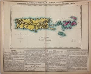
Condition: Very good condition. Fine original hand colored map of the Puerto Rico and the Virgin Islands, from the first edition of Carey and Lea's 'A Complete Historical, Chronological, and Geographical American Atlas, being a Guide to the History of North and South America, and the West Indies . to the Year 1822', the best atl…as of nineteenth century America. With the English, Danish and Spanish possessions indicated by color; with a very dramatic delineation of the mountains and coast line of 'Porto Rico'. A very vibrant, strong impression. With text below map and at both sides, pertaining to topography, climate, lands, towns, roads and canals, education, government and history. This map, according to History Detectives (Season 6, Episode 4: Lincoln Forgery) was evidently part of an Abraham Lincoln memorabilia scam in which a forger named Harry Sickles worked with Eugene Field II to pass off items in Field's collection as Lincoln items. Sickles and Field managed to convince William P. Brown, the still living coachman of Abraham Lincoln, that they wanted his signature on the verso of their items. Brown's signature, and the notary's signature are genuine; the text referring to the map being given by Mrs. Lincoln to Brown in 1866 was added by the forger. This is the handwritten note on the verso: "This is from the collection of old books, papers, maps, etc presented to her coachman, Wm. P Brown, by Mrs. Lincoln in 1866. (Signed) Wm P Brown. The signatures are genuine. (Signed) Frank E. Thatcher". There is a blue notary stamp, (Muskegon County, Mich. 1933) and a circular blind stamp. Howe's C133. Image size: 20 3/4 x 16 1/2" on paper 22 1/4 x 17 1/2".


