Order Total (1 Item Items):
Shipping Destination:

Illustrated Historical Atlas County Haldimand (1 results)
Feedback
Skip to main search results
Search filters
Product Type
- All Product Types
- Books (1)
- Magazines & Periodicals (No further results match this refinement)
- Comics (No further results match this refinement)
- Sheet Music (No further results match this refinement)
- Art, Prints & Posters (No further results match this refinement)
- Photographs (No further results match this refinement)
- Maps (No further results match this refinement)
- Manuscripts & Paper Collectibles (No further results match this refinement)
Condition Learn more
- New (No further results match this refinement)
- As New, Fine or Near Fine (No further results match this refinement)
- Very Good or Good (No further results match this refinement)
- Fair or Poor (1)
- As Described (No further results match this refinement)
Binding
- All Bindings
- Hardcover (1)
- Softcover (No further results match this refinement)
Collectible Attributes
- First Edition (1)
- Signed (No further results match this refinement)
- Dust Jacket (No further results match this refinement)
- Seller-Supplied Images (1)
- Not Print on Demand (1)
Language (1)
Price
- Any Price
- Under US$ 25 (No further results match this refinement)
- US$ 25 to US$ 50 (No further results match this refinement)
- Over US$ 50
Free Shipping
- Free Shipping to U.S.A. (No further results match this refinement)
Seller Location
Seller Rating
-
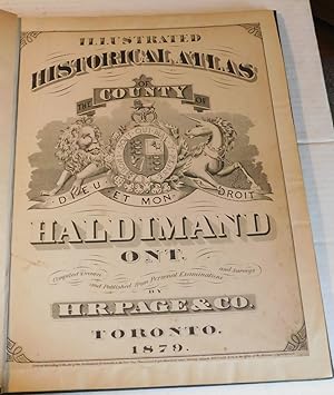
ILLUSTRATED HISTORICAL ATLAS OF THE COUNTY OF HALDIMAND ONT. Compiled Drawn and Published from Personal Examinations and Surveys by H.R. Page & Co.
Published by Toronto, Ontario: H.R. Page & Co., 1879., 1879
Seller: Blue Mountain Books & Manuscripts, Ltd., Cadyville, NY, U.S.A.
Seller rating 5 out of 5 stars

First Edition
Condition: Fair. - Folio, 17-3/4 inches high by 14-5/8 inches wide, Hardcover, rebound in dark green cloth with the original titling laid down. The covers are rubbed and stained. Pages [1]-24, [52-53], [1 leaf], [56-57], 1-49 & [1-5], as per the table of contents. The contents consist of the original title page which has been laid down on a larger sheet, a table of contents, the "Historical Sketch of the County of Haldimand" [pages 5 through 19], a "Business Directory of Haldimand County" [pages 20 through 24], a double-page color map of "Quebec and Lower Provinces" [paginated as 52-53 in the table of contents], a double-page color map of the "United States" [paginated as 56-57 in the table of contents], followed by profuse engraved maps & plates, with illustrations of local business cards on the last 4 pages. There is some foxing & soiling throughout with a few tiny marginal tears. A larger tear to the table of contents has been repaired with archival linen tape on the verso. The full-page plate of the "American Hotel, Jarvis" [page 15] has been repaired with linen tape along the lower inch of the image. The "Map of Ontario" on page 23 has been repaired with linen tape affecting some of the lower part of the image with corresponding repairs to the "Map of the Township of North Cayuga" on the verso [page 24]. There are several other small repairs to the edges of a few pages which does not affect the images. A complete RARE Canadian Atlas. RARE FIRST EDITION.