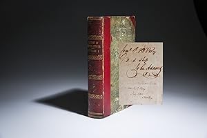
India Map: Signed (10 results)

- Signed
Seller: Antique Paper Company, ASHFORD, United KingdomAntique Paper Company
Contact seller2-star sellerCondition: Used
US$ 27.47
US$ 8.00 shippingShips from United Kingdom to U.S.A.Quantity: 2 available
Add to basket1878 - Antique Map COUNTRIES Between BRITISH INDIA & RUSSIAN ASIA (120) For more info please ask seller a question. Royal Mail 2nd Class - £0.00 Royal Mail 2nd Class Signed For - £4.50 Standard Int'l age - £4.00 Royal Mail International Signed - £8.00 No PICK UP OPTIONSorry, our items are NOT available for pick-up.PAYING VIA PAY…PALWe accept on our all our items so you can shop with confidence.Simple choose the option when proceeding through the checkout.

- Signed
Seller: Antique Paper Company, ASHFORD, United KingdomAntique Paper Company
Contact seller2-star sellerCondition: Used
US$ 27.47
US$ 8.00 shippingShips from United Kingdom to U.S.A.Quantity: 1 available
Add to basket1885 - MAP AFGHANISTAN TURKESTAN PERSIA INDIA Territories Iran (160) For more info please ask seller a question. Royal Mail 2nd Class - £0.00 Royal Mail 2nd Class Signed For - £4.50 Standard Int'l age - £4.00 Royal Mail International Signed - £8.00 No PICK UP OPTIONSorry, our items are NOT available for pick-up.PAYING VIA PAYPAL…We accept on our all our items so you can shop with confidence.Simple choose the option when proceeding through the checkout.
 More images
Published by Henry Herringman,, London, 1664
- Hardcover
- First Edition
- Signed
Seller: Antiquariaat FORUM BV, Houten, NetherlandsAntiquariaat FORUM BV
Contact seller5-star sellerCondition: Used
US$ 19,592.64
US$ 28.82 shippingShips from Netherlands to U.S.A.Quantity: 1 available
Add to basketFirst edition of the English translation of the notable biography of the fourth viceroy of Portuguese India, D. João de Castro (Lisbon, 1500 - Goa, 1548). De Castro was a renowned 16th-century Portuguese nobleman, scientist, naval officer, and writer. As a young man, he studied under the famous Portuguese mathematician and cosmo…grapher Pedro Nunes together with Luis, Duke of Beja, the second son of King Manuel I of Portugal. They became lifelong friends and Castro also accompanied Dom Luis to the siege of Tunis in 1535.De Castro sailed with, served under, and was connected to several prominent 16th-century Portuguese (noble-) men. His uncle, Garcia de Noronha, was the third viceroy of India, with whom he first sailed for India in the late 1530s. There, De Castro participated in the relief of Diu, which was besieged as part of the struggle for the possession of Diu and its fort due to its strategic importance as an outpost and dominance in that part of Portuguese India. He was responsible for the overthrow of Mahmud, King of Gujarat, whose interests threatened the Portuguese control of Goa coast. Furthermore, De Castro also served under Estêvão da Gama, second son of the famous Portuguese explorer Vasco da Gama, on expeditions to Suez and the Red Sea. Back in Portugal, in 1543, he was named commander of a fleet sent to clear Atlantic Europe of pirates, and two years later was sent with a fleet of six ships back to the East, where he was rewarded with the positions of governor and viceroy of Portuguese India. Unlike previous governors and viceroys of India, De Castro was actively interested in Indian culture and religion. De Castro was possibly also connected to Saint Francis Xavier, who served in the Jesuit mission in Portuguese India in the 1540s, as he was supposed to have died in Xavier's arms in 1548.During his travels between Portugal and India, including the expeditions he undertook with Da Gama along the Arabian coasts and to Egypt, De Castro collected important navigational, geographical and hydrographical information about these areas, which he presented in three "rutters" or itineraries/logbooks (in Portuguese: roteiros): Roteiro de Lisboa a Goa about his first voyage to India in 1538, Roteiro de Goa a Diu (written around 1539, regarding De Castro's rescue fleet relieving the Gujurati-Ottoman siege of the Portuguese fortress of Diu, and Roteiro do Mar Roxo (the Red Sea between East Africa and the Arabian Peninsula was then known as the "purple sea" - Mar Roxo). In his first rutter, De Castro recorded values of magnetic declination in the Atlantic and Indian Oceans, which he obtained through experiments with a magnetic needle on board. This early observation of the phenomenon of magnetic declination in the sixteenth century was useful for the study of terrestrial magnetism in later centuries.The hinges are somewhat weakened, the boards are slightly rubbed, both pastedowns have come loose from the inside of the boards, revealing an inscription on the inside of the front board in brown ink "H. 1. 13 [crossed out]" and "C 7. 18", and an inscription in brown ink on the recto of the front paste-down "E F G H". Some occasional, very minor foxing, the foot edge of the 15 leaves is very slightly damages, not affecting the text in any way. Overall in good condition.l ESTC R7129 (17 copies in the UK & US); Wing F 2155; WorldCat 835169356 (1 copy), 1064239444 (1 copy), 643713038 (1 copy), 1378914397 (1 copy); cf. Innocencio III, p. 239 (Portuguese ed.). Contemporary blind-tooled calf, sewn on 5 supports corresponding with the raised bands on the spine, with a manuscript title-label in the second compartment from the head of the spine, gold-tooled board edges. With a full-page engraved portrait of D. João de Castro, the fourth viceroy of India as a frontispiece, signed "W. Faithorne sculp.", one full-page engraved illustration of the shrine of St. Thomas in Meliapor - including its inscriptions in Sanskrit - which already existed at the time of the Portuguese arrival in India, and one double page engraved map (view) of Diu and its fortress. The title is set in a double fillet frame and the text is set in a single fillet frame, with an elaborate ornamental woodcut headpiece and a few detailed headpieces built up from typographic ornaments, with decorated woodcut initials. Pages: [1], [1 blank], [18], 272, [19], [1 blank] pp.
 More images
Published by Printed and Published by Abraham Small, Philadelphia 1819
- Hardcover
- Signed
Seller: The First Edition Rare Books, LLC, Cincinnati, U.S.A.The First Edition Rare Books, LLC
Contact seller5-star sellerCondition: Used - Very good
US$ 6,800.00
US$ 6.00 shippingShips within U.S.A.Quantity: 1 available
Add to basketHardcover. Condition: Very good. First American Edition. Octavo, xx, [21] - 482pp. Half red morocco over marbled boards, title in gilt on spine, decorative gilt over 5 raised bands. Marbled endpapers, bookplate from "Geo. S. Perry, Cadiz, Ohio" affixed to front endpaper. Bumped corners, worn edges, marbled boards with shelf wear… and rubbing. Includes two foldout maps, one of the American continent and the second a hand-colored illustration of the topography of South America, with some splitting at seams of the first map. Marginal tear to front free endpaper [Aa] and dampstaining to lower margin, not affecting text. (Sabin 6333) Signed by Oliver Hazard Perry on front free endpaper, with the following inscription: "Com'o. O.H. Perry / US Ship John Adams." Additional signature by his wife (Elizabeth Champlin Mason Perry) below the signature: "Mrs. E.C. Perry / Feb'y 1845 / Brooklyn." Provenance: Book was passed down through the Perry family. Sold at Sotheby's, 2018. In 1818, the Perry-Elliott affair came to a head when Perry wrote to Navy Secretary Benjamin Crowninshield preferring court-martial charges against his former subordinate. Not wishing to expose the nation to the controversial aspect of Perry's splendid victory on Lake Erie, President James Monroe offered the prestigious title of "Commodore" to Oliver if he'd drop the charges against Elliott. Upon accepting that offer in early 1819 Perry set sail for the Orinoco River, Venezuela, aboard the frigate John Adams (carrying this very book with him) accompanied by the schooner Nonsuch, there to discourage piracy, while maintaining friendly diplomatic relations with the Republic of Venezuela and the Republic of Buenos Aires. Shifting his flag to the shallow-draft Nonsuch Perry sailed upriver to Angostura to negotiate an anti-piracy agreement with President Simon Bolivar. A favorable treaty was signed on August 11 with Vice-President Francisco Antonio Zea in the absence of Bolivar (who was engaged in the liberation of New Granada), but when the schooner started downriver, many of her crew, including Perry, had been stricken with yellow fever. Despite the crew's efforts to reach Trinidad for medical assistance, the commodore died on board Nonsuch on August 23, 1819, his 34th birthday, as the ship was nearing Port of Spain, his flagship John Adams in sight. He was buried in Port of Spain with great honors while the Nonsuch's crew acted as honor guard. Perry's remains were taken back to the United States in 1826 and interred in Newport, Rhode Island. Originally interred in the Old Common Burial Ground, his body was eventually moved to Newport's Island Cemetery. The first American edition of Spanish America, from the personal library of Commodore Oliver Hazard Perry, inscribed by him enroute to South America aboard the U.S.S. John Adams. (illustrator). Signed.

- Signed
Seller: Antique Paper Company, ASHFORD, United KingdomAntique Paper Company
Contact seller2-star sellerCondition: Used
US$ 48.07
US$ 8.00 shippingShips from United Kingdom to U.S.A.Quantity: 2 available
Add to basket1879 November 1st Original Antique Print taken from The Graphic: THE BRITISH AND RUSSIAN FRONTIERS IN CENTRAL ASIA Overall size of this print is approx 40cm x 28cm with large margins, perfect for mounting for home, business, interior decorators, hotels, pubs, boardrooms and restaurants. All our prints are ORIGINALS ANTIQUES AND…GUARANTEED TO BE AS DATED. Please note we are offering an ANTIQUE PRINT on this listing unless otherwise described. These prints are taken from the THE GRAPHIC and in many cases, there will also be text on the reverse of the image side. The Graphic was first published in 1869, founded by William Luson Thomas and was a weekly newspaper reporting details of local, UK and worldwide events and stories. The Graphic is known for its coverage of of the following subjects: The Wars, Ships, Boats, Guns, Sailing, Portraits, Fine Art, Old and Antique Prints, Wood Cut, Wood Engravings, Early Photographs, Victorian Life, Victorian Culture, Kings, Queens, Royalty, Travels, Adventures, Natural History, Birds, Fish, Mammals, Fishing, Hunting, Shooting, Fox Hunting, Sprts including Tennis, Cricket, Football, Horse Racing etc. WE ARE HAPPY TO COMBINE POSTAGE FOR UP TO 10 ITEMS FOR NO ADDITIONAL CHARGE OVER THE SINGLE ITEM POSTAGE COST FOR OVERSEAS BUYERS. FOR UK BUYERS, POSTAGE IS FREE. PLEASE NOTE THAT IF YOU WOULD LIKE THE ITEM TO BE SENT BY TRACKED AND SIGNED FOR MAIL, YOU WILL NEED TO PAY THE APPROPRIATE HIGHER POSTAL CHARGE. 1879 Antique Print INDIA MAP Persia Iran Arabian Sea Afghanistan China (292) 1879 Antique Print INDIA MAP Persia Iran Arabian Sea Afghanistan China (292) 1879 Antique Print INDIA MAP Persia Iran Arabian Sea Afghanistan China (292)Click image to enlarge Description1879 Novembe.
 More images
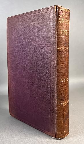
Published by Trubner & Co.; Thacker, Spink & co.; B.E.S. Press, London; Calcutta; Bombay 1885
- Signed
Seller: William Chrisant & Sons, ABAA, ILAB. IOBA, ABA, Ephemera Society, Fort Lauderdale, U.S.A.William Chrisant & Sons, ABAA, ILAB. IOBA, ABA, Ephemera Society
Contact seller5-star sellerCondition: Used - Very good
US$ 120.00
US$ 9.00 shippingShips within U.S.A.Quantity: 1 available
Add to basketCondition: Very Good. Front board detached. Faded purple cloth with gilt title to spine. Endpapers slightly darkened by binder's glue bleed. "N. Y. City. Oct. 2. 1917" inscribed on flyleaf. Includes black and white fold-out map of India according to Ptolemy and extensive index. Includes 96 page catalogue of Trubner's Oriental &…Linguistic Publications to rear. Wear to head and tail of spine. Clean interior with no previous owners' names or other defacements. Scarce. 6 x 9 in.
 More images
Published by Londres Printed by A. Godbid and J. Playford, for Moses Pitt at the Angel in S. Paul's Churchyard 1680 1680
- First Edition
- Signed
Seller: Librairie Vignes Online, Paris, FranceLibrairie Vignes Online
Contact seller5-star sellerCondition: Used - Near fine
US$ 2,374.87
US$ 46.11 shippingShips from France to U.S.A.Quantity: 1 available
Add to basketCondition: Bon état. in-4, demi-veau jaspé à coins, dos à nerfs encadrés de filets dorés, pièce de titre maroquin rouge, plats de papier peigné, non rogné, 1 f. + titre + 10 ff. (avertissement, dédicace, préface, table)+14-[4]-15-46-[4]-47-87+66 pp. Édition originale anglaise (l'originale française parut chez Clouzier l'année pr…écédente) qui contient une description du Tonkin, dérivée des observations du frère de l'auteur, une description du Japon, recueillie auprès de négociants, et une violente attaque contre les agents de la Compagnie néerlandaise des Indes orientales. La première partie, consacrée au royaume du Tunquin (Tonkin), est illustrée de 8 planches gravées dépliantes oblongues. Mais il manque la planche réunissant les cartes du Japon et du Tonkin. Initiales gravées sur bois et ornements en tête de chapitres. Notes manuscrites sur la première page muette (deux citations poétiques en anglais dont une d'Alexander Pope : "If to her share some female errors fall, Look on her face and you'll forget them all") et ex-libris manuscrit au bas de la page d'avertissement "Franceis Stephens book 1721". Cet ouvrage très rare est conservé dans une bonne reliure du début du XXe siècle, mais présente deux restaurations grossières (au premier feuillet de la préface et à la dernière gravure collée qui ne se déplie plus), quelques déchirures sans manque (notamment sur trois des gravures), quelques rousseurs et tâches.
- Signed
- Art Print
Seller: ThePrintsCollector, Zeeland, NetherlandsThePrintsCollector
Contact seller5-star sellerCondition: Used
US$ 240.46
US$ 20.75 shippingShips from Netherlands to U.S.A.Quantity: 1 available
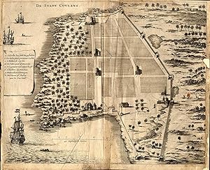
Add to basketPlate 137: 'De Stadt Coulang' (The city of Coulang). It shows: A plan of the city of Coulang (now known as Kollam, India). Scarce original etching / engraving on a verge type hand laid paper. Letterpress text on front and rear of the sheet. Description: This original engraving originates from the 1672 German edition of Baldaeus'… 'Nauwkeurige beschrijving Malabar en Choromandel, derz. aangrenzend rijken, en het machtige eiland Ceylon.' (transl: Description of the East Indian Countries of Malabar, Coromandel, Ceylon, etc.), printed in Amsterdam by Jacob van Velsen and published by Johannes Janssonius van Waesbergen en Johannes van Someren.Artists and Engravers: Author: Philip Baldaeus (1632-1672). Father Philippus Baldaeus, Baelde or Philip Balde (October 1632, Delft � 1672, Geervliet) was a Dutch minister. He went to Jaffna, Ceylon with an invading Dutch force during 17th Century. As the first European he documented the life, language and culture of Tamil people, living in the north of the island. It is a great historical record, similar to Mahawamsa, and it was immediately published in Dutch and German (with many beautiful plates). Some lates in this work signed G. Appelmans fe., being the engraver. Condition: Fair, given age. Paper repair to the right margin (a piece of the image chipped), original middle fold, creased, printer's fold, small tear in the fold General age-related toning and light staining, please study scan carefully. Storage location: LJC-A7-37 The overall size is ca. 14.2 x 11.6 inch. The image size is ca. 13.8 x 10.6 inch. The overall size is ca. 36 x 29.5 cm. The image size is ca. 35 x 27 cm.
 More images
- Signed
Seller: Bartele Gallery - The Netherlands, Langweer, NetherlandsBartele Gallery - The Netherlands
Contact seller5-star sellerCondition: Used
US$ 581.84
US$ 19.60 shippingShips from Netherlands to U.S.A.Quantity: 1 available
Add to basketTitle: 1616 Petrus Kaerius Map of Southern India and Ceylon ? Narsinga et Ceylon This rare early 17th-century copper engraved map titled 'Narsinga et Ceylon' was created by Petrus Kaerius (Pieter van den Keere) and published in 1616. It depicts the southern part of the Indian subcontinent, including the Coromandel and Malabar co…asts, and the island of Ceylon (modern Sri Lanka), with remarkable detail for its size. The map comes from 'Caert-Thresoor', a pocket atlas first issued in 1598 and reprinted with updated plates through the early 17th century. Key features include coastal towns such as Goa, Cochin, and Colombo, mountain ranges shown pictorially, and decorative cartouches framing the title and scale. It shows Portuguese place names such as Capelo and Dodolfsio, reflecting the Portuguese maritime dominance in the Indian Ocean during this period. The seas are labelled 'Mare Indicum' (Indian Ocean) and 'Sinus Gangeticus' (Bay of Bengal). The engraving is signed Petrus Kaerius caelavit in the scale cartouche, attesting to Kaerius' role as both engraver and mapmaker. Pieter van den Keere (Kaerius) was a prominent Dutch engraver and cartographer active in Amsterdam in the late 16th and early 17th centuries. His 'Caert-Thresoor' pocket maps were among the earliest affordable atlas maps available to merchants and scholars, preceding Blaeu's and Mercator's popular works. Maps from this series remain prized for their compact yet detailed style and historical value. Condition report: The map is in good condition for its age with strong engraving impressions. There is light age toning and minor foxing, with a few small edge nicks not affecting the image. The verso shows Latin text. Framing tips: This map will display elegantly in a slim black or dark wood frame with a gold inner edge to reflect its early 17th-century aesthetic. Pair it with a cream or warm ivory mat to highlight the paper's natural tone, making it ideal for libraries, studies, or map collections focused on early colonial and maritime Asia.

- Signed
Seller: Bartele Gallery - The Netherlands, Langweer, NetherlandsBartele Gallery - The Netherlands
Contact seller5-star sellerCondition: Used
US$ 759.96
US$ 19.60 shippingShips from Netherlands to U.S.A.Quantity: 1 available
Add to basketAntique map titled 'Carte de l'Inde en deca du Gange comprenant l' Indoustan (.)' A map of part of India, the Ganges and Hindustan. From: Antoine Francois Prevost d'Exiles' (or Abbe Prevost's) multi-volume "Histoire Generale Des Voyages" (1746-1759): ultimately 17 quarto volumes recounting major voyages of discovery and descript…ions of far flung parts and including around 240 maps, plans and charts of those areas. These maps, plans and charts were mostly produced by Jacques Nicolas Bellin, the influential French hydrographer. Bellin's work spans from around 1740 to the 1770s; interestingly he signed his plates in a variety of styles - J. Bellin, N. Bellin, N.B., M.B. (Monsieur Bellin) and S.B. (Seigneur Bellin). Artists and Engravers: Jacques-Nicolas Bellin (1703-1772) was a French hydrographer, geographer and member of The Philosophes. His career, spanning over 50 years, caused an enormous outpt in maps, particular of maritime interest.


