Johnsons China (16 results)

Language: English
Published by Sheffield 1851
Seller: K Books Ltd ABA ILAB, York, YORKS, United KingdomK Books Ltd ABA ILAB
Contact seller5-star sellerCondition: Used - Very good
US$ 20.40
US$ 25.74 shippingShips from United Kingdom to U.S.A.Quantity: 1 available
No Binding. Condition: Very Good. A fine original antique hand coloured engraving . Engraved portion approx. 5 x 4 inches, !3 x 9 cms, mounted and ready to frame, mount size approx 8 x 6 inches , 24 x 18 cms . very good condition, recent colouring, - a fine opportunity to acquire an attractive and unusual antique original engrav…ing, circa 1851. Internal view of the Shrewsbury chapel.

Published by A.J. Johnson, New York 1870
Seller: Nicholas D. Riccio Rare Books, ABAA, Florham Park, NJ, U.S.A.Nicholas D. Riccio Rare Books, ABAA
Contact seller4-star sellerUnbound, colored engraved map, decorative boarder, double page, 24" x17". Slight toning and aging; otherwise bright and clean and in very nice condition. Alvin Jewett Johnson (1827-1884) appears to have entered the map publishing business in 1860. It appears that he obtained J.H. Colton's map copyrights, and published the first…installment of the Johnson's New Illustrated (Steel Plate) Family Atlas In that year. Many of the maps Johnson would use would bear the J.H. Colton copyright for many years. Johnson's Atlas would run from 1860 to 1885. While Johnson would use somewhat similar boarder designs, map coloring would appear a little heavier than the earlier Colton maps. This double page map of China and Japan is from the 1870 edition of Johnson's Illustrated Family Atlas. The color is nice, and there is substantial detail on China. Also includes a small inset map of Canton and Hong Kong. Ristow 325-326.

Seller: Art Source International Inc., Boulder, CO, U.S.A.Art Source International Inc.
Contact seller5-star sellerNear the forefront of the atlas publication industry for a quarter century was mapmaker and aggressive marketer Alvin Jewitt Johnson. Around 1860, in a transaction that remains somewhat mysterious, Johnson acquired a set of detailed plates from J.H. Colton, one of the foremost mapmakers of the century, and used them to print the… Johnson atlas that was to find its way into homes across the country. Johnsons New Illustrated Family Atlas was first published in 1860, and today these maps have become prized collectibles and true works of cartographic art. The attention to detail and fine hand coloring of these maps make them some of the best collectibles maps from the 19th century. This map measures 15.5 inches by 12.5 inches.

Seller: Art Source International Inc., Boulder, CO, U.S.A.Art Source International Inc.
Contact seller5-star sellerThis finely detailed map came from Johnson's New Illustrated (Steel Plate) Family Atlas. Map shows cities and towns, rail lines, rivers and lakes, and wagon trails/roads. Each region is individually colored, and includes the traditional decorative border. Includes inset maps of Canton and Amoy. This map measures 15.5 inches by 1…2.5 inches.

Seller: Art Source International Inc., Boulder, CO, U.S.A.Art Source International Inc.
Contact seller5-star sellerThis map is from Johnsons New Illustrated Family Atlas of the World printed in 1868 by A.J. Johnson. Johnson maps are characterized by hand coloring in red and green and distinctive borders, including iron scroll work and a Celtic design.This is a beautiful map of China and Japan colored in vibrant pastels. Details include the n…ames of important cities, rivers, lakes and mountains.An inset included shows the vicinity of Canton and Hong Kong. This map measures 22.5 inches by 16.25 inches.
Seller: Muse Book Shop, DeLand, FL, U.S.A.Muse Book Shop
Contact seller5-star sellerCondition: Used - Very good
US$ 70.00
US$ 7.00 shippingShips within U.S.A.Quantity: 1 available
No Binding. Condition: Very Good. 1865 Map of China by Johnson and Ward in near fine condition.

Seller: Art Source International Inc., Boulder, CO, U.S.A.Art Source International Inc.
Contact seller5-star sellerThis antique map came from Johnson's New Illustrated (Steel Plate) Family Atlas, published in 1867, by A.J. Johnson. These maps are some of the most colorful and accurate maps produced in the 1860's, their attention to detail and the fine steel engraving make them works of art. Johnson maps are characterized by hand coloring in…red, green, yellow, and pink and distinctive borders, including iron scrollwork and a Celtic design. This beautiful map of China shows countries, states and or provinces and regions, cities and towns, lakes, rivers, and water bodies, railroads, forts, and wagon trails. A fine piece that would make a nice addition to any wall in a home or office. Includes inset maps of Canton and Amoy. This map measures 15.5 inches by 13 inches.

Seller: Art Source International Inc., Boulder, CO, U.S.A.Art Source International Inc.
Contact seller5-star sellerJohnson and Browning produced "Johnsons New Illustrated Steel Plate Family Atlas" in 1862. China is illustrated on this detailed, hand colored map. Insets show Canton and Amoy at a greater scale. Regions are distinguished by bright pastel colors. Railroads, major roads, rivers, lakes, mountains, and the names of regions and impo…rtant cities are identified. This map measures 15.25 inches by 12.75 inches.

Seller: Art Source International Inc., Boulder, CO, U.S.A.Art Source International Inc.
Contact seller5-star sellerThis antique map came from Johnsons New Illustrated (Steel Plate) Family Atlas, published in 1863, by Johnson and Ward. These maps are some of the most colorful and accurate maps produced in the 1860's. Johnson maps are characterized by hand coloring in red and green and distinctive borders, including iron scrollwork and a Celti…c design. This beautiful map of China includes insets of Amoy and Canton. This map measures 16 inches by 13 inches.

Seller: Art Source International Inc., Boulder, CO, U.S.A.Art Source International Inc.
Contact seller5-star sellerNear the forefront of the atlas publication industry for a quarter century was mapmaker and aggressive marketer Alvin Jewitt Johnson. Around 1860, in a transaction that remains somewhat mysterious, Johnson acquired a set of detailed plates from J.H. Colton, one of the foremost mapmakers of the century, and used them to print the… Johnson atlas that was to find its way into homes across the country. Johnsons New Illustrated Family Atlas was first published in 1860, and today these maps have become prized collectibles and true works of cartographic art. The attention to detail and fine hand coloring of these maps make them some of the best collectibles maps from the 19th century. This signal page map illustrates China with inset map of the Harbor and Island of Amoy and Canton. Provinces, departments, districts, cities and towns are noted. This map measures 13 inches by 15.5 inches.

Published by A.J. Johnson, New York 1867
Seller: Nicholas D. Riccio Rare Books, ABAA, Florham Park, NJ, U.S.A.Nicholas D. Riccio Rare Books, ABAA
Contact seller4-star sellerNew York: A.J. Johnson, 1867. Unbound, colored engraved map, decorative boarder, 16" x13". Slight toning and aging, a couple of chips at the edge of a very ample margin; otherwise bright and clean and in very nice condition. Alvin Jewett Johnson (1827-1884) appears to have entered the map publishing business in 1860. It appears…that he obtained J.H. Colton's map copyrights, and published the first installment of the Johnson's New Illustrated (Steel Plate) Family Atlas In that year. Many of the maps Johnson would use would bear the J.H. Colton copyright for many years. Johnson's Atlas would run from 1860 to 1885. While Johnson would use somewhat similar boarder designs, map coloring would appear a little heavier than the earlier Colton maps. This map of China is from the 1867 edition of Johnson's Illustrated Family Atlas, and has nice coloring and substantial detail. The J.H. Colton 1855 copyright still appears on this map. May require extra postage. Ristow 325-326.
Published by Johnson and Ward. (circa1864)., (New York). 1864
Seller: Asia Bookroom ANZAAB/ILAB, Canberra, ACT, AustraliaAsia Bookroom ANZAAB/ILAB
Contact seller5-star sellerCondition: Used
US$ 126.41
US$ 21.25 shippingShips from Australia to U.S.A.Quantity: 1 available
Handcoloured map, 32 x 39.8 cms (including decorative border); 35.5 x 46 cms (sheet), insets of the harbor and island of Amoy and Canton and adjacent islands, unrelated text on the verso, very slight age toning, clean and bright in very good condition. Detailed map by leading American map maker and publisher Johnson & Ward, acti…ve as a partnership from the 1860s.

- First Edition
Seller: Art Source International Inc., Boulder, CO, U.S.A.Art Source International Inc.
Contact seller5-star sellerThis map was issued as part of the extremely difficult to find Johnson's New Illustrated (Steel Plate) Family Atlas, With Descriptions, Geographical, Statisical, and Historical - Compiled, Drawn, and Engraved Under the Supervision of J.H. Colton and A.J. Johnson, T.B. Tilden. This is the first edition of this atlas by A.J. Johns…on which was issued almost every year from 1860-1887. Johnson's Atlas "accurately reflects the expansion of our country, showing the growth of cities, towns and counties, as well as the emerging state boundaries in the west, and the development of the railroads nationwide." This map measures 15 inches by 12.5 inches.

Seller: Art Source International Inc., Boulder, CO, U.S.A.Art Source International Inc.
Contact seller5-star sellerThis colorful map came from Johnsons New Illustrated (steel plate) Family Atlas. Includes the the characteristic iron scrollwork decorative border. Shows railroads, common roads, canals, townships, and villages. This map is in great condition, and would look nice framed! This map also has nice insets of Canton and the Harbor & I…sland of Amoy. This map measures 15.5 inches by 12.5 inches.
 More images
Published by Johnson and Browning c. 1861, New York 1861
Seller: Haaswurth Books, Binghamton, NY, U.S.A.Haaswurth Books
Contact seller5-star sellerCondition: Used - Very good
US$ 95.00
US$ 6.95 shippingShips within U.S.A.Quantity: 1 available
Map. Condition: Very good. Large hand-colored map, 45.7 x 36 cm (18 x 14 inches), clean, suitable for framing. Top border with a few short repairs that will be covered with the frame mat when you have it framed. Removed from a bound volume, Johnson's New Illustrated Family Atlas. This map shows the roads, rivers, cities, provinc…es and districts.Includes inset illustrations of the Harbor & Island of Amoy and a Map of Canton and adjacent Islands. The Johnson and Browning imprint dates this map between 1860 and 1862. Alvin Jewett Johnson (1827-1884), b. Wallingford, Vermont; school teacher, for some years a book and map seller for J. H. Colton and Co. After some efforts at publishing his own maps, Johnson found success with his Family Atlas, publishing them in Richmond, Virginia and in New York City beginning in 1860. He and his partner Ross C. Browning (1822-1899) evidently purchased rights to Colton's maps, as they appear in the first Johnson's Family Atlas. Johnson updated his maps as cartography became more accurate, and Atlases during the 1860's were bound with maps bearing various dates until that particular map was updated. Johnson and Browning maps were published 1860-1862; Johnson and Ward were years 1862-1866; maps published by A. J. Johnson, A. J. Johnson and Son, A. J. Johnson & Co., date from 1866-1887.Johnson's hand-colored maps are known for their accuracy to detail and are an important record of internal improvements and westward expansion. All are suitable for framing and valued by collectors.
 More images
Seller: Bartele Gallery - The Netherlands, Langweer, FRL, NetherlandsBartele Gallery - The Netherlands
Contact seller5-star sellerCondition: Used
US$ 389.46
US$ 19.48 shippingShips from Netherlands to U.S.A.Quantity: 1 available
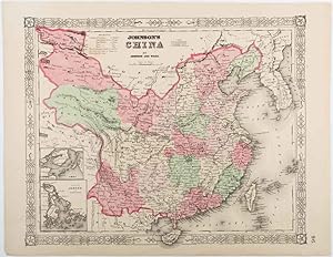
Johnson's China Map with Canton Inset, USA Published c.1864 ? Hand-Colored This is a finely engraved and hand-colored map titled Johnson's China, published by Johnson and Ward in New York circa 1864. It shows detailed political divisions, provinces, and cities of China in the mid-19th century, with bright pastel pink and green w…ash coloring. The map features an ornate decorative border typical of Johnson's atlases, adding to its aesthetic appeal. Notable is the inset at the lower left showing the Bay of Canton (Guangzhou) and the island of Amoy (Xiamen), important trading ports for European and American merchants during this period. The main map depicts cities, towns, rivers, mountain ranges, and coastal features with clarity, including Peking (Beijing), Nanking (Nanjing), Shanghai, Canton, Amoy, and Formosa (Taiwan). Johnson and Ward were leading map and atlas publishers in the United States during the mid-19th century. Their maps combined accurate cartographic detail with decorative presentation, making them popular for family atlases and educational use. This map reflects American perspectives on China during a time of increasing trade relations and missionary activity. Condition report: Good condition. Strong impression with bright original hand coloring. Light general age toning and minor marginal spots or handling marks, typical for antique atlas maps. Small tears around the borders. Wide margins and plate mark intact. Framing suggestion: Frame with a simple dark wood or black frame and an archival off-white mat to emphasize the soft pastel coloring and decorative border. Use UV-protective glass to preserve color vibrancy and paper stability.


