Johnsons Florida (22 results)
 More images
- Manuscript
Seller: Versandhandel Boeger, Weil am Rhein, , GermanyVersandhandel Boeger
Contact seller5-star sellerCondition: Used
US$ 5.91
US$ 2.87 shippingShips from Germany to U.S.A.Quantity: 1 available
 More images
- Manuscript
Seller: Versandhandel Boeger, Weil am Rhein, , GermanyVersandhandel Boeger
Contact seller5-star sellerCondition: Used
US$ 6.98
US$ 2.87 shippingShips from Germany to U.S.A.Quantity: 1 available
Carte Postale Alte Postkarte Homestead Florida Howard Johnsons Motor Lodge / / postalisch nicht gelaufen nach 1965 Erhaltung siehe scans [WerneD78] [WernPID7 kv127box ].
 More images
- Manuscript
Seller: Versandhandel Boeger, Weil am Rhein, , GermanyVersandhandel Boeger
Contact seller5-star sellerCondition: Used
US$ 6.98
US$ 2.87 shippingShips from Germany to U.S.A.Quantity: 1 available
Carte Postale Alte Postkarte Homestead_Florida Howard Johnson's Motor Lodge Swimming Pool postalisch nicht gelaufen nach 1965 Erhaltung siehe scans [FriedD77] Frierer.
 More images
- Manuscript
Seller: Versandhandel Boeger, Weil am Rhein, , GermanyVersandhandel Boeger
Contact seller5-star sellerCondition: Used
US$ 6.98
US$ 2.87 shippingShips from Germany to U.S.A.Quantity: 1 available
Carte Postale Alte Postkarte Hollywood Florida Howard Johnsons Motor Lodge / / postalisch nicht gelaufen nach 1965 Erhaltung siehe scans [LiesaD40] [LiesID40 kc025box ].
 More images
- Manuscript
Seller: Versandhandel Boeger, Weil am Rhein, , GermanyVersandhandel Boeger
Contact seller5-star sellerCondition: Used
US$ 6.98
US$ 2.87 shippingShips from Germany to U.S.A.Quantity: 1 available
Carte Postale Alte Postkarte Homestead Florida Howard Johnsons Motor Lodge / / postalisch nicht gelaufen nach 1965 Erhaltung siehe scans [WerneD78] [WernPID7 kv127box ].
 More images
- Manuscript
Seller: Versandhandel Boeger, Weil am Rhein, , GermanyVersandhandel Boeger
Contact seller5-star sellerCondition: Used
US$ 6.98
US$ 2.87 shippingShips from Germany to U.S.A.Quantity: 1 available
Carte Postale Alte Postkarte Homestead Florida Howard Johnsons Motor Lodge Homestead postalisch nicht gelaufen nach 1965 Erhaltung siehe scans Alte Ansichtskarte Postkarte LiesID40.
 More images
- Manuscript
Seller: Versandhandel Boeger, Weil am Rhein, , GermanyVersandhandel Boeger
Contact seller5-star sellerCondition: Used
US$ 6.98
US$ 2.87 shippingShips from Germany to U.S.A.Quantity: 1 available
Carte Postale Alte Postkarte St Petersburg Florida Howard Johnsons Motor Lodge postalisch gelaufen nach 1965 Erhaltung siehe scans Alte Ansichtskarte Postkarte LiesID40.
 More images
- Manuscript
Seller: Versandhandel Boeger, Weil am Rhein, , GermanyVersandhandel Boeger
Contact seller5-star sellerCondition: Used
US$ 6.98
US$ 2.87 shippingShips from Germany to U.S.A.Quantity: 1 available
Carte Postale Alte Postkarte Homestead_Florida Howard Johnson's Motor Lodge Swimming Pool postalisch nicht gelaufen nach 1965 Erhaltung siehe scans [FriedD77] Frierer.
 More images
- Manuscript
Seller: Versandhandel Boeger, Weil am Rhein, , GermanyVersandhandel Boeger
Contact seller5-star sellerCondition: Used
US$ 6.98
US$ 2.87 shippingShips from Germany to U.S.A.Quantity: 1 available
Carte Postale Alte Postkarte Panama City Florida Johnsons Motel Court St Andrew Bay Panama City postalisch gelaufen 1960 Erhaltung siehe scans Frierer.
 More images
- Manuscript
Seller: Versandhandel Boeger, Weil am Rhein, , GermanyVersandhandel Boeger
Contact seller5-star sellerCondition: Used
US$ 9.21
US$ 2.87 shippingShips from Germany to U.S.A.Quantity: 1 available
Howard Johnsons Florida Center Hotel at night Alte Ansichtskarte Postkarte 1977 postalisch gelaufen.
 More images
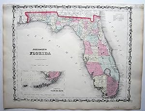
Published by Johnson and Browning, New York . 1860
- Map
Seller: Angelika C. J. Friebe Ltd. - MapWoman, Dorking, United KingdomAngelika C. J. Friebe Ltd. - MapWoman
Contact seller5-star sellerCondition: Used - Good
US$ 272.60
US$ 26.47 shippingShips from United Kingdom to U.S.A.Quantity: 1 available
No Binding. Condition: Good. lithographed map with original colouring; image 31 x 39 cm. paper edges slightly browned; top margin cut into decorative border which has been repaired (see photo); o/w very good cond.- A very decorative and detailed map of Florida with an inset of the Florida Keys, from Johnson's 'New Illustrated Fa…mily Atlas, With Descriptions, Geographical, Statistical, And Historical. Compiled, Drawn, and Engraved Under The Supervision of J. H. Colton And A. J. Johnson'.

Published by A.J. Johnson, New York 1863
- First Edition
Seller: Raptis Rare Books, Palm Beach, FL, U.S.A.Raptis Rare Books
Contact seller5-star sellerRare 19th century example of Johnson's famed Civil War era map of the state of Florida. One page, the hand-colored lithographic map depicts the state in full with color coding according to county in the midst of the American Civil War with references to towns, railroads, villages, depots, swamps, the territories of Native Americ…an tribes, forts and battle sites related to the Seminole Wars, Lake Okeechobee, the Everglades, Indian Hunting Grounds between Fort Poinsett and Key Biscayne Bay, Tampa Bay and the Okefenokee Swamp. Additionally notes the course of a proposed canal route leading from Tampa to the Atlantic and the Arredondo Grant to the west of St. Augustine. An inset map in the lower left hand quadrant details the Florida Keys. Featuring the fretwork style border common to Johnsonâs atlas work from 1863 to 1869. In near fine condition. Matted and framed. The entire piece measures 24 inches by 21.25 inches. Historical records indicate that Paleo-Indians entered Florida at least 14,000 years ago, by the 16th century, the primary Native American tribes included the Apalachee of the Florida Panhandle, the Timucua of northern and central Florida, the Ais of the central Atlantic coast, and the Calusa of southwest Florida, with many smaller groups throughout what is now Florida. Florida was the first region of the continental United States to be visited and settled by Europeans. The earliest known European explorers came with the Spanish conquistador Juan Ponce de Leà n who spotted and landed on the peninsula on April 2, 1513 and named it La Florida in recognition of the verdant landscape and because it was the Easter season, which the Spaniards called Pascua Florida. At various points in its colonial history, Florida was administered by Spain and Great Britain and on March 3, 1845, Florida was admitted as the 27th state of the Union. The principal location of the Seminole Wars (the longest and most extensive of Indian Wars in United States history fought between 1816 and 1858), Florida declared its secession from the Union on January 10, 1861, and was one of the seven original Confederate States. After the Civil War, Florida was restored to the Union on June 25, 1868.

Published by A.J. Johnson c. 1861, New York 1861
- First Edition
Seller: Raptis Rare Books, Palm Beach, FL, U.S.A.Raptis Rare Books
Contact seller5-star sellerRare 19th century example of Johnson's famed Civil War era map of the state of Florida. One page, the hand-colored lithographic map depicts the state in full with color coding according to county in the midst of the American Civil War with references to towns, railroads, villages, depots, swamps, the territories of Native Americ…an tribes, forts and battle sites related to the Seminole Wars, Lake Okeechobee, the Everglades, Indian Hunting Grounds between Fort Poinsett and Key Biscayne Bay, Tampa Bay and the Okefenokee Swamp. Additionally notes the course of a proposed canal route leading from Tampa to the Atlantic and the Arredondo Grant to the west of St. Augustine. An inset map in the lower left hand quadrant details the Florida Keys. Featuring the strapwork style border common to Johnsonâs atlas work from 1860 to 1863. In near fine condition. Matted and framed. The entire piece measures 24 inches by 21.5 inches. Historical records indicate that Paleo-Indians entered Florida at least 14,000 years ago, by the 16th century, the primary Native American tribes included the Apalachee of the Florida Panhandle, the Timucua of northern and central Florida, the Ais of the central Atlantic coast, and the Calusa of southwest Florida, with many smaller groups throughout what is now Florida. Florida was the first region of the continental United States to be visited and settled by Europeans. The earliest known European explorers came with the Spanish conquistador Juan Ponce de Leà n who spotted and landed on the peninsula on April 2, 1513 and named it La Florida in recognition of the verdant landscape and because it was the Easter season, which the Spaniards called Pascua Florida. At various points in its colonial history, Florida was administered by Spain and Great Britain and on March 3, 1845, Florida was admitted as the 27th state of the Union. The principal location of the Seminole Wars (the longest and most extensive of Indian Wars in United States history fought between 1816 and 1858), Florida declared its secession from the Union on January 10, 1861, and was one of the seven original Confederate States. After the Civil War, Florida was restored to the Union on June 25, 1868.

Seller: Art Source International Inc., Boulder, CO, U.S.A.Art Source International Inc.
Contact seller5-star sellerJohnson and Browning produced this steel plate, hand colored map for "Johnsons New Illustrated Family Atlas" in 1862. Florida is illustrated on this detailed map. An inset shows the Florida Keys at the same scale. Counties are distinguished by bright pastel colors. Other details include lakes, rivers, railroads, and the names of… states, counties, and important cities. This map measures 15.25 inches by 12.5 inches.

Seller: Art Source International Inc., Boulder, CO, U.S.A.Art Source International Inc.
Contact seller5-star sellerThis map was made by Johnson and Ward in 1863. Vibrant colors, fine detail and a decorative scroll work border are among the features of this beautiful map. The state of Florida is illustrated, counties, cities, railroads, commons, canals, villages and forts are all noted. Also included is an inset map of the Plan of the Florida… Keys. This map measures 15 inches by 12.5 inches.

Seller: Art Source International Inc., Boulder, CO, U.S.A.Art Source International Inc.
Contact seller5-star sellerThis map is from Johnsons New Illustrated Family Atlas of the World printed in 1868 by A.J. Johnson. Johnson maps are characterized by hand coloring in red and green and distinctive borders, including iron scroll work and a Celtic design. This beautiful map of Florida is colored in vibrant pastels and has details including the n…ames of counties and important cities, rail lines, lakes and rivers.The Everglades are identified as is the land occupied at that time by the Seminole Indians in Southern Florida. An inset is included that shows the Keys at the same scale as the main map and indicates the Indian hunting ground. This map measures 15 inches by 11.75 inches.

Seller: Art Source International Inc., Boulder, CO, U.S.A.Art Source International Inc.
Contact seller5-star sellerNear the forefront of the atlas publication industry for a quarter century was mapmaker and aggressive marketer Alvin Jewitt Johnson.Around 1860, in a transaction that remains somewhat mysterious, Johnson acquired a set of detailed plates from J.H. Colton, one of the foremost mapmakers of the century, and used them to print the…Johnson atlas that was to find its way into homes across the country.Johnsons New Illustrated Family Atlas was first published in 1860, and today these maps have become prized collectibles and true works of cartographic art.The attention to detail and fine hand coloring of these maps make them some of the best collectibles maps from the 19thcentury.This single page map illustrates the state of Florida, with an inset map of the Florida Keys.Counties, cities, towns, railroads and common roads are noted.Great detailing and coloring. This map measures 15.5 inches by 12.5 inches.

Seller: Art Source International Inc., Boulder, CO, U.S.A.Art Source International Inc.
Contact seller5-star sellerNear the forefront of the atlas publication industry for a quarter century was mapmaker and aggressive marketer Alvin Jewitt Johnson. Around 1860, in a transaction that remains somewhat mysterious, Johnson acquired a set of detailed plates from J.H. Colton, one of the foremost mapmakers of the century, and used them to print the… Johnson atlas that was to find its way into homes across the country. Johnsons New Illustrated Family Atlas was first published in 1860, and today these maps have become prized collectibles and true works of cartographic art. The attention to detail and fine hand coloring of these maps make them some of the best collectibles maps from the 19th century. This map shows Florida, with an inset of the Florida keys. Cities, towns, roads, lakes, rivers and counties are shown. This map measures 18 inches by 14 inches.

Seller: Art Source International Inc., Boulder, CO, U.S.A.Art Source International Inc.
Contact seller5-star sellerThis map was made by Johnson and Ward in 1865. Vibrant colors, fine detail and a decorative border are among the features of this beautiful map. The state of Florida is illustrated, counties, cities, railroads, commons, canals, villages and forts are all noted. Also included is an inset map of the Plan of the Florida Keys. This…map measures 15 inches by 12.5 inches.

- First Edition
Seller: Art Source International Inc., Boulder, CO, U.S.A.Art Source International Inc.
Contact seller5-star sellerThis map was issued as part of the extremely difficult to find Johnson's New Illustrated (Steel Plate) Family Atlas, With Descriptions, Geographical, Statisical, and Historical - Compiled, Drawn, and Engraved Under the Supervision of J.H. Colton and A.J. Johnson, T.B. Tilden. This is the first edition of this atlas by A.J. Johns…on which was issued almost every year from 1860-1887. Johnson's Atlas "accurately reflects the expansion of our country, showing the growth of cities, towns and counties, as well as the emerging state boundaries in the west, and the development of the railroads nationwide." This map measures 18 inches by 14 inches.

Published by Johnson & Browning ca. 1860, New York 1860
Seller: Haaswurth Books, Binghamton, NY, U.S.A.Haaswurth Books
Contact seller5-star sellerCondition: Used - Good
US$ 400.00
US$ 6.95 shippingShips within U.S.A.Quantity: 1 available
Engraving. Condition: Good. Large hand-colored map, 46 x 36 cm (18 x 14 1/4 inches), clean, suitable for framing. Small nicks to the paper on one edge that will mat out when framed. Some small spots of foxing. Will ship flat. Removed from a bound volume, Johnson's New Illustrated Family Atlas, and is plate no. 36. This map was p…ublished published about the year 1860. Hand-colored in pink, cream, and green. There is an inset map, "Plan of the Florida Keys." In the middle and southern part of the state there is little development inland with many of the locations being forts. The lower tip of the Everglades is identified as "Indian Hunting Grounds."Alvin Jewett Johnson (1827-1884), b. Wallingford, Vermont; school teacher, for some years a book and map seller for J. H. Colton and Co. After some efforts at publishing his own maps, Johnson found success with his Family Atlas, publishing them in Richmond, Virginia and in New York City beginning in 1860. He and his partner Ross C. Browning (1822-1899) evidently purchased rights to Colton's maps, as they appear in the first Johnson's Family Atlas. Johnson updated his maps as cartography became more accurate, and Atlases during the 1860's were bound with maps bearing various dates until that particular map was updated. Johnson and Browning maps were published 1860-1862; Johnson and Ward were years 1862-1866; maps published by A. J. Johnson, A. J. Johnson and Son, A. J. Johnson & Co., date from 1866-1887.Johnson's hand-colored maps are known for their accuracy to detail and are an important record of internal improvements and westward expansion. All are suitable for framing and valued by collectors.


