
Johnsons Mexico (41 results)
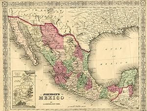
Published by Johnson and Ward, New York 1865
Seller: Pazzo Books, Boston, MA, U.S.A.Pazzo Books
Contact seller5-star sellerCondition: Used - Very good
US$ 40.00
US$ 6.00 shippingShips within U.S.A.Quantity: 1 available
Condition: Very Good Condition. Plate image measure 15" x 13"; mild foxing and browning. faint wear in the margin - an attractive map. ca. 1865 Size: Octavo (8vo). Quantity Available: 0. Shipped Weight: Under 1 kilo. Category: Prints, maps, broadsides; Inventory No: 044582.
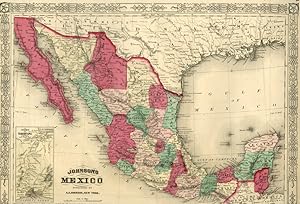
Published by Johnson and Ward, New York 1867
Seller: Pazzo Books, Boston, MA, U.S.A.Pazzo Books
Contact seller5-star sellerCondition: Used - Very good
US$ 50.00
US$ 6.00 shippingShips within U.S.A.Quantity: 1 available
Condition: Very Good Condition. Plate image measure 15" x 13"; mild foxing and browning. faint wear in the margin - an attractive map. ca. 1867 Size: Octavo (8vo). Quantity Available: 1. Shipped Weight: Under 1 kilo. Category: Prints, maps, broadsides; Inventory No: 044580.

Published by Johnson 1866,7,8 or 9., NY 1866
- Softcover
Seller: Quiet Friends IOBA, Lyndonville, NY, U.S.A.Quiet Friends IOBA
Contact seller4-star sellerSoftcover. "FINE" map, hand colored, 13" high x 17" wide. FLAWLESS. Inset of Tehuantipec. Johnson's name (by itself, without the added "Browning", "Ward" or "and son") is printed in double faced outline and was not used until 1866. In addition the particular border style, with a five pointed star at each corner, went out in 1869…. Hence the 1866-9 date. This info from Ira Lourie's Johnson Map Project. "FINE" map. Published between 1866 & 1869.

Published by Johnson and Browning 1861
Seller: Muse Book Shop, DeLand, FL, U.S.A.Muse Book Shop
Contact seller5-star sellerCondition: Used - Very good
US$ 70.00
US$ 10.00 shippingShips within U.S.A.Quantity: 1 available
No Binding. Condition: Very Good. Map, hand colored.

Published by Johnson and Ward 1862
- Map
Seller: Hidalgo Books, San Antonio, TX, U.S.A.Hidalgo Books
Contact seller4-star sellerCondition: Used - Very good
US$ 69.00
US$ 7.00 shippingShips within U.S.A.Quantity: 1 available
No Binding. Condition: Very Good. Fine map of 1862 Mexico before the Imperial Government of Mexico under Maximilian decided to redraw the state's maps. A few small tears at perimeter, otherwise pristine.

Language: English
- Hardcover
- Print on Demand
Seller: S N Books World, Delhi, , IndiaS N Books World
Contact seller5-star sellerLeatheBound. Condition: New. BOOKS ARE EXEMPT FROM IMPORT DUTIES AND TARIFFS; NO EXTRA CHARGES APPLY. Leatherbound edition. Condition: New. Leather Binding on Spine and Corners with Golden leaf printing on spine. Bound in genuine leather with Satin ribbon page markers and Spine with raised gilt bands. Pages: 762. A perfect gift…for your loved ones. Reprinted from 1839 edition. NO changes have been made to the original text. This is NOT a retyped or an ocr'd reprint. Illustrations, Index, if any, are included in black and white. Each page is checked manually before printing. As this print on demand book is reprinted from a very old book, there could be some missing or flawed pages, but we always try to make the book as complete as possible. Fold-outs, if any, are not part of the book. If the original book was published in multiple volumes then this reprint is of only one volume, not the whole set. IF YOU WISH TO ORDER PARTICULAR VOLUME OR ALL THE VOLUMES YOU CAN CONTACT US. Resized as per current standards. Sewing binding for longer life, where the book block is actually sewn (smythe sewn/section sewn) with thread before binding which results in a more durable type of binding. Volume v.2 Language: English Pages: 762 Volume v.2.

Language: English
- Hardcover
- Print on Demand
Seller: S N Books World, Delhi, , IndiaS N Books World
Contact seller5-star sellerLeatheBound. Condition: New. BOOKS ARE EXEMPT FROM IMPORT DUTIES AND TARIFFS; NO EXTRA CHARGES APPLY. Leatherbound edition. Condition: New. Leather Binding on Spine and Corners with Golden leaf printing on spine. Bound in genuine leather with Satin ribbon page markers and Spine with raised gilt bands. Pages: 766. A perfect gift…for your loved ones. Reprinted from 1839 edition. NO changes have been made to the original text. This is NOT a retyped or an ocr'd reprint. Illustrations, Index, if any, are included in black and white. Each page is checked manually before printing. As this print on demand book is reprinted from a very old book, there could be some missing or flawed pages, but we always try to make the book as complete as possible. Fold-outs, if any, are not part of the book. If the original book was published in multiple volumes then this reprint is of only one volume, not the whole set. IF YOU WISH TO ORDER PARTICULAR VOLUME OR ALL THE VOLUMES YOU CAN CONTACT US. Resized as per current standards. Sewing binding for longer life, where the book block is actually sewn (smythe sewn/section sewn) with thread before binding which results in a more durable type of binding. Volume v.1 Language: English Pages: 766 Volume v.1.
Language: English
- Hardcover
- Print on Demand
Seller: S N Books World, Delhi, , IndiaS N Books World
Contact seller5-star sellerLeatherBound. Condition: NEW. BOOKS ARE EXEMPT FROM IMPORT DUTIES AND TARIFFS; NO EXTRA CHARGES APPLY. Leatherbound edition. Condition: New. Leather Binding on Spine and Corners with Golden leaf printing on spine. Bound in genuine leather with Satin ribbon page markers and Spine with raised gilt bands. Pages: 760. A perfect gift… for your loved ones. Reprinted from 1839 edition. NO changes have been made to the original text. This is NOT a retyped or an ocr'd reprint. Illustrations, Index, if any, are included in black and white. Each page is checked manually before printing. As this print on demand book is reprinted from a very old book, there could be some missing or flawed pages, but we always try to make the book as complete as possible. Fold-outs, if any, are not part of the book. If the original book was published in multiple volumes then this reprint is of only one volume, not the whole set. IF YOU WISH TO ORDER PARTICULAR VOLUME OR ALL THE VOLUMES YOU CAN CONTACT US. Resized as per current standards. Sewing binding for longer life, where the book block is actually sewn (smythe sewn/section sewn) with thread before binding which results in a more durable type of binding. Volume 2 Language: English Pages: 760 Volume 2.
Language: English
- Hardcover
- Print on Demand
Seller: S N Books World, Delhi, , IndiaS N Books World
Contact seller5-star sellerLeatherBound. Condition: NEW. BOOKS ARE EXEMPT FROM IMPORT DUTIES AND TARIFFS; NO EXTRA CHARGES APPLY. Leatherbound edition. Condition: New. Leather Binding on Spine and Corners with Golden leaf printing on spine. Bound in genuine leather with Satin ribbon page markers and Spine with raised gilt bands. Pages: 768. A perfect gift… for your loved ones. Reprinted from 1839 edition. NO changes have been made to the original text. This is NOT a retyped or an ocr'd reprint. Illustrations, Index, if any, are included in black and white. Each page is checked manually before printing. As this print on demand book is reprinted from a very old book, there could be some missing or flawed pages, but we always try to make the book as complete as possible. Fold-outs, if any, are not part of the book. If the original book was published in multiple volumes then this reprint is of only one volume, not the whole set. IF YOU WISH TO ORDER PARTICULAR VOLUME OR ALL THE VOLUMES YOU CAN CONTACT US. Resized as per current standards. Sewing binding for longer life, where the book block is actually sewn (smythe sewn/section sewn) with thread before binding which results in a more durable type of binding. Volume 1 Language: English Pages: 768 Volume 1.

Seller: Art Source International Inc., Boulder, CO, U.S.A.Art Source International Inc.
Contact seller5-star sellerNear the forefront of the atlas publication industry for a quarter century was mapmaker and aggressive marketer Alvin Jewitt Johnson. Around 1860, in a transaction that remains somewhat mysterious, Johnson acquired a set of detailed plates from J.H. Colton, one of the foremost mapmakers of the century, and used them to print the… Johnson atlas that was to find its way into homes across the country. Johnsons New Illustrated Family Atlas was first published in 1860, and today these maps have become prized collectibles and true works of cartographic art. The attention to detail and fine hand coloring of these maps make them some of the best collectibles maps from the 19th century. This signal page map illustrates Mexico, with an inset map of the territory and isthmus of Tehuantepec. This map measures 15.5 inches by 12.5 inches.

Seller: Art Source International Inc., Boulder, CO, U.S.A.Art Source International Inc.
Contact seller5-star sellerThis antique map came from Johnson's New Illustrated (Steel Plate) Family Atlas, published in 1863, by Johnson and Ward. These maps are some of the most colorful and accurate maps produced in the 1860's. Johnson maps are characterized by hand coloring in red and green and distinctive borders, including iron scrollwork and a Celt…ic design. This beautiful map of Mexico includes an inset of Tehuantepec. This map measures 15.5 inches by 12.5 inches.

Seller: Art Source International Inc., Boulder, CO, U.S.A.Art Source International Inc.
Contact seller5-star sellerNear the forefront of the atlas publication industry for a quarter century was mapmaker and aggressive marketer Alvin Jewitt Johnson. Around 1860, in a transaction that remains somewhat mysterious, Johnson acquired a set of detailed plates from J.H. Colton, one of the foremost mapmakers of the century, and used them to print the… Johnson atlas that was to find its way into homes across the country. Johnson's New Illustrated Family Atlas was first published in 1860, and today these maps have become prized collectibles and true works of cartographic art. The attention to detail and fine hand coloring of these maps make them some of the best collectibles maps from the 19th century. This map measures 15.5 inches by 12.5 inches.

Seller: Art Source International Inc., Boulder, CO, U.S.A.Art Source International Inc.
Contact seller5-star sellerThis hand colored map of Mexico was made by Johnson and Ward in 1862. Political regions are differentiated by well-maintained pastel colors. The names of regions, states, important cities and capitols, rivers, some locations of ruins, mountain ranges and lakes are provided on this very detailed map. An inset shows the Territory…and Isthmus of Tehuantepec at a greater scale. This map measures 15.25 inches by 12.25 inches.

Seller: Art Source International Inc., Boulder, CO, U.S.A.Art Source International Inc.
Contact seller5-star sellerThis finely detailed map came from Johnson's New Illustrated (Steel Plate) Family Atlas. Map shows cities and towns, rail lines, rivers and lakes, and wagon trails/roads. Each region is individually colored, and includes the traditional decorative border. Includes inset of Territory and Isthmus of Tehuantepec. This map measures…15.5 inches by 12.5 inches.

Seller: Art Source International Inc., Boulder, CO, U.S.A.Art Source International Inc.
Contact seller5-star sellerThis map is from Johnsons New Illustrated Family Atlas of the World printed in 1868 by A.J. Johnson. Johnson maps are characterized by hand coloring in red and green and distinctive borders, including iron scroll work and a Celtic design. This page contains two maps- Mexico on the left and Central America on the right half. Both… maps are colored in vibrant pastels. Details on the maps include the names of countries and important cities, mountain ranges and rivers. The map of Central America contains an inset of Panama at a greater scale than the main map. This map measures 17 inches by 22.75 inches.

Published by Johnson and Ward, New York 1863
Seller: Argosy Book Store, ABAA, ILAB, New York, NY, U.S.A.Argosy Book Store, ABAA, ILAB
Contact seller5-star sellerunbound. Map. Engraving with original hand coloring. Image measures 12.5" x 15". This beautiful 1863 map was issued by Johnson and Ward. The map includes Texas, Guatemala and other nearby regions. It features an inset featuring the Territory and Isthmus of Tehuantepec, the site of a proposed trans-continental canal similar to th…e Panama Canal. The canal was never built. Several cities, towns, canals, and topographic details are noted throughout the map, including "uninhabited" deserts with "isolated mountains without grass, wood or water." Features the Johnson border used between 1861 - 1863. The map is in good condition with minor toning and spotting. Exhibits chips along margins, not affecting printed image. Alvin Jewett Johnson (1827-1884) was one of the most prolific American publishers of the 19th century. He opened his own company in 1856 that produced atlases, maps and encyclopedias. The company made great maps based on those by J.H. Colton, and Johnson produced a newly updated version every year up until the late 19th century.

Published by Alvin Jewett Johnson, New York 1864
- Map
Seller: mediumraremaps.com, Franklin, TN, U.S.A.mediumraremaps.com
Contact seller5-star sellerCondition: Used - Very good
US$ 198.00
US$ 6.00 shippingShips within U.S.A.Quantity: 1 available
23 1/2 x 16 3/4 inches. Condition: Very good condition. This isan early edition of Johnson's classic map of the American West and Southwest. The map of California shows a large number of railroads developing the coast and inward. The bottom of Nevada has been ceded by Arizona. The four corners states are prominently displayed. T…he western states are characterized by huge counties making administration difficult and sporadic.

Seller: Art Source International Inc., Boulder, CO, U.S.A.Art Source International Inc.
Contact seller5-star sellerThis colorful map came from Johnson's New Illustrated (steel plate) Family Atlas. Includes the the characteristic iron scrollwork decorative border. Shows railroads, common roads, canals, townships, and villages. This map is in great condition, and would look nice framed! Also has an inset map of "Territory and Isthmus of Tehuan…tepec". This map measures 15.5 inches by 12.5 inches.
Published by JOHNSON AND WARD, New York 1865
- First Edition
- Map
Seller: T. W. Palmer Books, Eugene, OR, U.S.A.T. W. Palmer Books
Contact seller5-star sellerCondition: Used - Very good
US$ 350.00
US$ 4.00 shippingShips within U.S.A.Quantity: 1 available
No Binding. Condition: Very Good. No Jacket. 1st Edition. 46 x 67 cm, counties colored, topography by hachure, strap work border, maps 66, 67, verso: page 78, HISTORICAL AND STATISTICAL VIEW OF MEXICO AND CENTRAL AMERICA, HISTORICAL AND STATISTICAL VIEW OF THE UNITED STATES, 1860, losses to edges outside of neat line.
Published by ca. 1850 1850
Seller: PLAZA BOOKS ABAA, Port Townsend, WA, U.S.A.PLAZA BOOKS ABAA
Contact seller1-star sellerHand-colored lithographed map, 31.5 x 38.7 cm. Nicely colored map of Mexico, including most of Texas, Louisiana, and a bit of Southern California around San Diego. Interestingly, Arizona and the souther part of New Mexico are shown, but Arizona is shown as a strip which stretches from the Texas border to California along the Mex…ican border -- basically the Gadsden Purchase -- and New Mexico is shown above it. (This configuration of Arizona would later be claimed by the Confederacy as part of their territory.) There is an inset of the Isthmus of Tejuantepec on the bottom left. These details aid in dating the map to about 1854, while the negotiations about the Gadsden Purchase were being finalized, negotiations which included permission for the US to build a railroad across the Isthmus -- this was never granted in the final treaty. This early version -- perhaps the earliest -- of Johnson's map does not appear in OCLC, although there are two copies of the later 1862 map; only one copy of this version of this map, the earliest dated, shown at auction. The coloring is very nice, bright. Map is near fine condition.

Published by circa 1865 1865
Seller: Art Source International Inc., Boulder, CO, U.S.A.Art Source International Inc.
Contact seller5-star sellerThis finely detailed U.S. state map came from Johnson's New Illustrated (steel Plate) Family Atlas. Map shows towns, rail lines, rivers and lakes, counties, and wagon trails.Each county is individually colored, and includes the traditional decorative border. This map measures 23.5 inches by 17.5 inches.
Published by A hand-colored map published by Johnson and Browning, undated but about 1860 1860
Seller: Up-Country Letters, Gardnerville, NV, U.S.A.Up-Country Letters
Contact seller2-star sellerA hand-colored map published by Johnson and Browning, undated but about 1860 (see David Rumsey Map Collection, Stanford Univ., online. The Rumsey copy is designated the first issue, with atlas page numbers 47-48; the map for sale here is identical except for the atlas pagination, 54-55, and is likely from a later atlas issue). S…hows much of the far West with boundaries much different than they are today. This was a fraught time for the West and the federal government. Two prominent examples are shown in this map: Nevada/Utah - for years the people of western Utah Territory had been lobbying Washington to separate from the rest of Utah Territory, even if it meant joining California. In 1859 the exploitation of the Comstock Lode enhanced the lobbying power of the separatists. Western Utah (Nevada) unilaterally declared withdrawal from Utah, wrote a constitution that pledged allegiance to the federal government, and elected a governor and legislature. The federal legislature and President Lincoln made it a Territory of its own in 1861, a State in 1864. This anticipatory map, a "hybrid" Territorial/State map, shows the eastern boundary snug against the eastern edge of the Great Salt Lake in Utah, about 100 miles east of the current eastern boundary. Arizona/New Mexico - After the Gadsden Purchase of 1853, the southern part of New Mexico Territory had mainly been settled by pro-slavery people, especially Texans. In fact, in 1861 the southern New Mexico region would declare itself part of the Confederacy. This area had long been known by the Mexicans as "Arizona", and is shown here as such. These Nevada and Arizona situations seem to have been anticipated by the federal government by the map-makers, and probably by the federal government, in this 1860 map. A few months after Lincoln s election, seven southern states seceded from the United States, withdrawing their federal legislators, which enabled those who remained to approve the new Territory of Nevada. The Arizona Territory would not be created until 1863, and in a very different form than shown here. Arizona and New Mexico would not become states until 1912. Minor edge chipping and marginal toning. 25 in X 18 in. In Very Good condition. Will be carefully shipped in a mailing tube.

Seller: Art Source International Inc., Boulder, CO, U.S.A.Art Source International Inc.
Contact seller5-star sellerThis antique map came from Johnsons New Illustrated (Steel Plate) Family Atlas, published in 1867, by A.J. Johnson. These maps are some of the most colorful and accurate maps produced in the 1860's, their attention to detail and the fine steel engraving make them works of art. Johnson maps are characterized by hand coloring in r…ed, green, yellow, and pink and distinctive borders, including iron scrollwork and a Celtic design. This beautiful map of Mexico and Central America shows countries, states and or provinces and regions, cities and towns, lakes, rivers, and water bodies, railroads, forts, and wagon trails. A fine piece that would make a nice addition to any wall in a home or office. Includes numerous inset maps of several regions and cities. This map measures 15.5 inches by 24 inches.

- First Edition
Seller: Art Source International Inc., Boulder, CO, U.S.A.Art Source International Inc.
Contact seller5-star sellerThis map was issued as part of the extremely difficult to find Johnson's New Illustrated (Steel Plate) Family Atlas, With Descriptions, Geographical, Statisical, and Historical - Compiled, Drawn, and Engraved Under the Supervision of J.H. Colton and A.J. Johnson, T.B. Tilden. This is the first edition of this atlas by A.J. Johns…on which was issued almost every year from 1860-1887. Johnson's Atlas "accurately reflects the expansion of our country, showing the growth of cities, towns and counties, as well as the emerging state boundaries in the west, and the development of the railroads nationwide." This map measures 15 inches by 12 inches.

Published by Johnson & Browning c. 1861, New York 1861
Seller: Haaswurth Books, Binghamton, NY, U.S.A.Haaswurth Books
Contact seller5-star sellerCondition: Used - Very good
US$ 200.00
US$ 6.95 shippingShips within U.S.A.Quantity: 1 available
Map. Condition: Very good. Large hand-colored map, 45.7 x 36 cm (18 x 14 inches), clean, suitable for framing. Several dark spots from age. Removed from a bound volume, Johnson's New Illustrated Family Atlas, plate 56. This map shows the roads, rivers, cities, provinces and districts. Includes inset illustrations of the the Terr…itory and Ishmus of Tehuantepec. The Johnson and Browning imprint dates this map between 1860 and 1862. Alvin Jewett Johnson (1827-1884), b. Wallingford, Vermont; school teacher, for some years a book and map seller for J. H. Colton and Co. After some efforts at publishing his own maps, Johnson found success with his Family Atlas, publishing them in Richmond, Virginia and in New York City beginning in 1860. He and his partner Ross C. Browning (1822-1899) evidently purchased rights to Colton's maps, as they appear in the first Johnson's Family Atlas. Johnson updated his maps as cartography became more accurate, and Atlases during the 1860's were bound with maps bearing various dates until that particular map was updated. Johnson and Browning maps were published 1860-1862; Johnson and Ward were years 1862-1866; maps published by A. J. Johnson, A. J. Johnson and Son, A. J. Johnson & Co., date from 1866-1887.Johnson's hand-colored maps are known for their accuracy to detail and are an important record of internal improvements and westward expansion. All are suitable for framing and valued by collectors.
 More images
Published by Johnson & Ward, New York 1864
Seller: Haaswurth Books, Binghamton, NY, U.S.A.Haaswurth Books
Contact seller5-star sellerCondition: Used - Very good
US$ 295.00
US$ 6.95 shippingShips within U.S.A.Quantity: 1 available
Map. Condition: Very good. Large double-plate hand-colored map, 46 x 67.5 cm (18 x 26 3/4 inches), clean, suitable for framing. Will ship folded at center, as found. Removed from a bound volume, Johnson's New Illustrated Family Atlas. This map has a printed copyright date of 1864. It map shows roads, emigrant & explorers routes,… rivers, counties, and locales. The counties are hand-painted in colors. There are proposed railroad routes, active waggon [sic] roads, forts, Indian tribes, and towns. An historic map of the American West.Alvin Jewett Johnson (1827-1884), b. Wallingford, Vermont; school teacher, for some years a book and map seller for J. H. Colton and Co. After some efforts at publishing his own maps, Johnson found success with his Family Atlas, publishing them in Richmond, Virginia and in New York City beginning in 1860. He and his partner Ross C. Browning (1822-1899) evidently purchased rights to Colton's maps, as they appear in the first Johnson's Family Atlas. Johnson updated his maps as cartography became more accurate, and Atlases during the 1860's were bound with maps bearing various dates until that particular map was updated. Johnson and Browning maps were published 1860-1862; Johnson and Ward were years 1862-1866; maps published by A. J. Johnson, A. J. Johnson and Son, A. J. Johnson & Co., date from 1866-1887.Johnson's hand-colored maps are known for their accuracy to detail and are an important record of internal improvements and westward expansion. All are suitable for framing and valued by collectors.

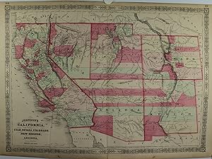
1864 Johnsons California with Utah, Nevada, Colorado, New Mexico, and Arizona
Johnsons California with Utah, Nevada, Colorado, New Mexico, and Arizona
- Map
Seller: New World Cartographic, Chicago, IL, U.S.A.New World Cartographic
Contact seller4-star sellerBy: Johnson & WardDate: 1864 (published) New YorkDimensions: 17.5 x 24 inches (44.5 x 61 cm)This is handsome map of the American Southwest showing the state of California and the territories of Utah, Nevada, Colorado, New Mexico, and Arizona. The map was published during the Civil War, when westward expansion was well underway b…ut prior to the completion of any trans-continental railroad, when the west was truly wild!The map presents what would become the southwestern states in a period of constant change, with regards of the indigenous people that inhabited the land for over millennia prior, the new settlers and miners pouring into the region, territorial boundaries, expansive counties, and continual founding of new towns and settlements. Wagon routes and paths of exploration from past expeditions are delineated throughout the map, many with names and dates that include Captain Sitgreaves (1851), Captain Gunnison (1853), Lieut. Fremont (1842,43,45), Proposed Pacific Railroad routes, the Spanish Trail from Great Salt Lake to Santa Fe, and the short-lived yet legendary route of the Pony Express, to name a few.The map captures a time when the southwestern United States was still sparsely populated and defined by vast stretches of untamed land. Settlement and exploration were influenced by the recent end of the Mexican-American War in 1848, which had incorporated these lands into the United States. The Southwests development during this period was driven by mining, agriculture, and the gradual influx of settlers seeking opportunities in the West.About Alvin Jewett JohnsonAlvin Jewett Johnson (18271884) was an influential American publisher and mapmaker known for his detailed and decorative maps of the United States. Initially working as a book canvasser, Johnson shifted his focus to cartography in the 1850s, partnering with other notable mapmakers to produce maps and atlases. By the early 1860s, Johnson had established his own publishing company, producing his signature Johnson's Family Atlas, which included some of the most accurate and finely detailed maps of the era. Johnsons maps were known for their distinct borders and meticulous attention to political boundaries, making them popular for both educational and decorative purposes. His work provides a valuable historical record of the American landscape during a period of significant expansion and change.Condition: Map is in B+ condition with exception color over clean paper. The only condition issue is the top left margin which has somewhat deteriorated just above the page number. Still, enough margin remains for framing.Inventory #128881200 W. 35th Street #425 Chicago, IL 60609 | P: (312) 496 - 3622.
 More images
- Art Print
Seller: Graphik-Antiquariat Jason Düssel, Berlin, GermanyGraphik-Antiquariat Jason Düssel
Contact seller5-star sellerCondition: Used
US$ 263.08
US$ 63.86 shippingShips from Germany to U.S.A.Quantity: 1 available
Kolorierte Lithografie bei Johnson und Ward in New York erschienen. Coloured lithograph published by Johnson and Ward in New York, 1864. 43 x 59,5 cm inkl. Bordüre. Unten 2 Flecken, links im Bild senkrechte Knickfalte, sonst gut erhalten. 2 stains at lower margin, vertical crease at left side of image, otherwise well preserved.

Seller: Art Source International Inc., Boulder, CO, U.S.A.Art Source International Inc.
Contact seller5-star sellerThis map is from Johnsons New Illustrated Family Atlas of the World printed in 1868 by A.J. Johnson. Johnson maps are characterized by hand coloring in red and green and distinctive borders, including iron scroll work and a Celtic design. It is colored in vibrant pastels and illustrates mountains, rivers, rail lines and the name…s of important cities. This map measures 23.5 inches by 16.75 inches.

Seller: Art Source International Inc., Boulder, CO, U.S.A.Art Source International Inc.
Contact seller5-star sellerThis antique map came from Johnson's New Illustrated (Steel Plate) Family Atlas, published in 1867, by A.J. Johnson. These maps are some of the most colorful and accurate maps produced in the 1860's, their attention to detail and the fine steel engraving make them works of art. Johnson maps are characterized by hand coloring in…red, green, yellow, and pink and distinctive borders, including iron scrollwork and a Celtic design. This beautiful map of the States of California, Utah, Nevada, Colorado, New Mexico and Arizona shows counties, cities and towns, lakes, rivers, and water bodies, mountains, railroads, forts, and wagon trails. A fine piece that would make a nice addition to any wall in a home or office. This map also shows numerous Native American Indian Tribes, many old forts, and explorer routes heading west. Also noted on map The Pony Express Route (U.S. Mail). This map measures 23 inches by 17 inches.


