
Order Total (1 Item Items):
Shipping Destination:

Kill Kull, Used (9 results)
Skip to main search results
Search filters
Product Type
- All Product Types
- Books (7)
- Magazines & Periodicals (1)
- Comics (No further results match this refinement)
- Sheet Music (No further results match this refinement)
- Art, Prints & Posters (No further results match this refinement)
- Photographs (No further results match this refinement)
- Maps (1)
- Manuscripts & Paper Collectibles (No further results match this refinement)
Condition Learn more
- New (No further results match this refinement)
- As New, Fine or Near Fine (7)
- Very Good or Good
- Fair or Poor
- As Described (2)
Binding
Collectible Attributes
- First Edition (1)
- Signed (No further results match this refinement)
- Dust Jacket (No further results match this refinement)
- Seller-Supplied Images (4)
- Not Print on Demand (9)
Language (2)
Free Shipping
- Free Shipping to U.S.A. (No further results match this refinement)
Seller Location
Seller Rating
-

Progress Report on Kill Van Kull Bridge Between Bayonne, N. J., and Port Richmond, Staten Island, N. Y.; 2nd 1931
Language: English
Published by Hassell Street Press, 2021
ISBN 10: 1014069769 ISBN 13: 9781014069764
Condition: As New. Unread book in perfect condition.
-

First Progress Report on Kill Van Kull Bridge Between Bayonne, N.J. and Port Richmond, Staten Island, N.Y., April 1930
Language: English
Published by Hassell Street Press, 2021
ISBN 10: 1013938402 ISBN 13: 9781013938405
Condition: As New. Unread book in perfect condition.
-
Progress Report on Kill Van Kull Bridge Between Bayonne, N. J., and Port Richmond, Staten Island, N. Y.; 2nd 1931
Language: English
Published by Hassell Street Press, 2021
ISBN 10: 1014069769 ISBN 13: 9781014069764
Seller: GreatBookPricesUK, Woodford Green, United Kingdom
Seller rating 5 out of 5 stars

US$ 22.45
US$ 20.04 shipping
Ships from United Kingdom to U.S.A.Quantity: Over 20 available
Add to basketCondition: As New. Unread book in perfect condition.
-
First Progress Report on Kill Van Kull Bridge Between Bayonne, N.J. and Port Richmond, Staten Island, N.Y., April 1930
Language: English
Published by Hassell Street Press, 2021
ISBN 10: 1013938402 ISBN 13: 9781013938405
Seller: GreatBookPricesUK, Woodford Green, United Kingdom
Seller rating 5 out of 5 stars
US$ 24.87
US$ 20.04 shipping
Ships from United Kingdom to U.S.A.Quantity: Over 20 available
Add to basketCondition: As New. Unread book in perfect condition.
-

Le g�nie civil tome XCV n� 9 - Pont en arc de 504 m�tres sur le Kill van Kull pr�s de New York par P. Caufourier, Note sur le flambement des arcs surbaiss�s par L. Tournayre, Les r�cents progr�s des boites de vitesses pour automobiles par G. Delanghe
Published by Bureau de la revue 31 aout 1929, 1929
Couverture souple. Condition: bon. R110449465: 31 aout 1929. In-12. Broch�. Bon �tat, Couv. convenable, Dos satisfaisant, Int�rieur frais. Pagin� de 193 � 216. Nombreuses illustrations en noir et blanc dans et hors texte. . . . Classification Dewey : 624-G�nie civil.
-
Les Ponts sur le Kill Van Kull � New York
Seller: Librairie Alain Brieux, Paris, France
Association Member: ILAB
Seller rating 4 out of 5 stars

Couverture rigide. Condition: Bon. 54 pp Paris, Otua, S.D (Vers 1933), in-4, 54 pp, Broch�, couverture imprim�e en noir, bleu et blanc, Revue de m�tallurgie illustr�e en noir ainsi que par de belles photographies en noir sur la construction du pont Kill Van Kull � New York. Bon �tat malgr� des taches aux plats de couverture.
-

LE PONT Sur Le Kill Van Kull A New-York.
Published by [Paris: Office Technique Pour L'Utilization D eL'Acier, c1933]., 1933
Seller: D & E LAKE LTD. (ABAC/ILAB), Toronto, ON, Canada
Seller rating 2 out of 5 stars

4to. pp. 54. 58 b/w illus. & diagrams. biblio. wrs. (light silverfish damage & tears to spine & back cover bit spotted).
-
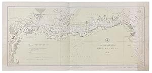
Kill Van Kull
Published by Published by the United States Coast and Geodetic Survey, Washington D.C., 1921
Seller: Donald A. Heald Rare Books (ABAA), New York, NY, U.S.A.
Seller rating 5 out of 5 stars
Map
Nautical chart printed on heavy paper stock. Colored. A rare original coastal survey of the border between New York and New Jersey at Kill Van Kull including Staten Island, Elizabeth, Newark Bay, Bayonne, and New York Bay. Established by President Thomas Jefferson in 1807 as the Survey of the Coast, the U.S. Coast and Geodetic Survey was the United States' first civilian scientific agency. This agency has followed its mission to survey the U.S. coastline, create nautical charts of the coast, and help increase maritime safety since its founding, and has often played fascinating roles in significant chapters of U.S. history. It served in all theaters of the Civil War in the service of the Union Army and Navy, pioneered acoustic exploration in the wake of the sinking of the Titanic, and during WWI it worked to detect enemy submarines. In addition, this agency worked to survey and produce detailed maps and renderings of the U.S. coast. These nautical survey maps (commonly referred to as "T-sheets") provide fascinating insights into the history of the United States coastline, which has and will continue to shift. These maps are the most important data source for understanding the physical and ecological characteristics of the U.S. shoreline. The present map is a highly detailed and accurate sea chart of the coastal border between New York and New Jersey at Kill Van Kull, and an important historical view of the developing states.
-
LE PONT SUR LE KILL VAN KULL A NEW YORK - 1932 - BAYONNE BRIDGE, ACIER
Published by OTUA, 1932
Magazine / Periodical First Edition
Couverture souple. Condition: Bon. Edition originale. OTUA - Note technique - Le Pont sur le Kill van Kull � New York - non dat� (vers 1932). Suppl�ment � la revue Acier publi�e par l'OTUA. importante publication enti�rement consacr�e au pont sur le Kill van Kull ou Pont de Bayonne (Bayonne Bridge) � New York (Arch. Othmar Ammann et Cass Gilbert), . couverture de Troy. illustrations en noir et blanc. 21 x 27 cm - 56 pages. bon �tat (petites salissures sur les couvertures). frais de port suppl�mentaires � pr�voir.


