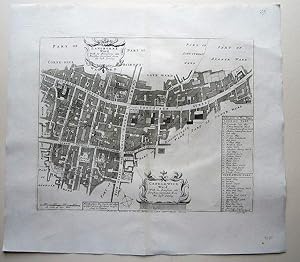
Langborne Ward (4 results)

Published by London 1720
- First Edition
- Art Print
Seller: Trillium Antique Prints & Rare Books, Franklin, TN, U.S.A.Trillium Antique Prints & Rare Books
Contact seller2-star sellerCondition: Used - Fine
US$ 100.00
US$ 10.00 shippingShips within U.S.A.Quantity: 1 available
Condition: Fine. 1st Edition. This historic engraving is from John Stow's "A Survey of the Cities of London and Westminster. Corrected, Improved, and Very Much Enlarged. to the Present Time" completed by John Strype. This is the fifth edition of the work published by Churchill [and others] in 1720 in London. It is the first Stry…pe edition, the best and most desriable. John Stow originally published the work in 1698 and John Strype improved upon and enlarged the work. --- The work featured exact maps of the city, surrounding suburbs, and wards. It also included engravings of some important buildings and estates. Stow's work was the "starting point of all inquiry into the subject of Elizabethan London." Of the ward maps, Hyde noted "Many of these maps are excellent. Their clarity and accuracy fulfill the requirements of the student of London history." (Hyde) Johannes Kip was responsible for many of the building or monument engravings. --- "The reader of A Survey travels with Stow through each of the city's wards and the adjoining city of Westminster, learns about the wall, bridges, gates, and parish churches . . . [Stow] also records the negative aspects of urban growth, in the shape of unsightly sprawl, filth, the destruction of ancient monuments, and above all poverty. His book approaches the thoroughness of an encyclopaedia . . . It is noteworthy that while Camden's Britannia was written in Latin for the educated à lite, Stow's Survey was composed in the language of his fellow countrymen." --- "Throughout his life at Low Leyton, Strype crossed the River Lea into London each week to meet and converse with his antiquarian friends and to call on his contacts in the book trade. . . . The Survey had been repeatedly revised and enlarged in order to keep up with the changing aspect of the post-fire city, now much expanded and altered in its religion and other ways. . . . Although Strype had arranged most of the work by 1707, and the engravings had been prepared, it was set aside after the publication of Edward Hatton's New View of London in 1708, which seemed to cover much the same ground and was considerably smaller and cheaper. . . . Finally, once the defects of Hatton's book were acknowledged another agreement in November 1716 led to the Survey's publication at the end of 1720. . . . The print run was probably more than 500 copies . . . To quote Merritt, By this stage the Survey has a multiple personality, switching with little warning from nostalgic Elizabethan antiquary [Stow] . . . to diligent post-Restoration recorder of events [Strype] and back again." (Merritt, 87) --- The work is in very good to excellent condition. There may be a few minor imperfections to be expected with age. Please review the image carefully for condition and contact us with any questions. --- Paper Size ~ 17 3/8" by 15 1/2".

Published by London 1720
- Map
Seller: Robert Frew Ltd. ABA ILAB, London, , United KingdomRobert Frew Ltd. ABA ILAB
Contact seller5-star sellerCondition: Used
US$ 103.57
US$ 13.41 shippingShips from United Kingdom to U.S.A.Quantity: 1 available
Original engraved plan (30 x 37 cm.). (Adams, 25, 27).
Published by W.Innys and J.Richardson [et al], London 1754
- Map
Seller: Angelika C. J. Friebe Ltd. - MapWoman, Dorking, United KingdomAngelika C. J. Friebe Ltd. - MapWoman
Contact seller5-star sellerCondition: Used - Very good
US$ 345.24
US$ 26.81 shippingShips from United Kingdom to U.S.A.Quantity: 1 available
No Binding. Condition: Very Good. copper engraved map; overall 42 x 45 cm, plate 30 x 36 cm. folds as issued; some foxing, staining and off-set; some discolouration in centrefold ; paper imperfections ; o/w vg cond. First published in 1720, Strype s re-issue appears as a much larger and expanded, 2 volume publication of Stow s S…urvey which, originally, was published in 1598. Strype added to Stow s original account numerous information about customs, institutions, monuments, charities, events like the Great Fire of London, the guilds and wards as well as detailed descriptions of the parish churches, and the city itself, and used a lot of Stow s original 17th century material that was excluded by Stow himself. Ward map with Table of Reference from Strype s A Survey of the Cities of Westminster, and the Borough of Southwark. Containing The Original, Antiquity, Increase, present State and Government of those cities. Written in the Year 1698.[corrected to 1598 in Vol II] Corrected, Improved, and very much Enlarged, in the year 1720, By John Strype. . There are 25 ancient wards in the City of London which are still used for local elections. John Strype was the son of Huguenot immigrants from Brabant who was educated at St. Paul s School and later at Jesus College,Cambridge. After completing his studies in 1669, he became curate of Theydon Bois and afterwards in Leyton.Though never being inducted, he was licensed by the Bishop of London to preach and expound the word of God, and to perform the office of priest and curate while it was vacant . In 1711, he obtained the sinecure of.

- Map
Seller: Antique Paper Company, ASHFORD, KENT, United KingdomAntique Paper Company
Contact seller2-star sellerCondition: Used
US$ 241.67
US$ 8.04 shippingShips from United Kingdom to U.S.A.Quantity: 1 available
1755 LANGBORNE WARD - CANDLEWICK WARD WITH ITS DIVISIONS INTO PARISHES. CORRECTED FROM THE LAST SURVEYA fine antique engraved print published for A SURVEY OF THE CITIES OF LONDON AND WESTMINSTER AND THE BOROUGH OF SOUTHWARK edited by John Strype.The map includes Lombard Street, Gracechurch Street, Fenchurch Street, Eastcheap Can…non Street. The Monument is shown off Fish Street HillExcellent condition with central fold as issued with later hand colour. Overall size approx. 45.5cm (18in) x 41cm (16andfrac12;in) including margins. The son of Thomas Stow, a tallow-chandler, John Stow was born about 1525 in London, in the parish of St Michael, Cornhill. He was admitted to the Merchant Taylors company in 1547 and had established by that year a business at a house near the well within Aldgate, between Leadenhall and Fenchurch Street. Pretty soon his antiquarian nature took charge. He made the acquaintance of the leading antiquarians of his time, including William Camden, and in 1561 he published his first work, The works of Geffrey Chaucer, newly printed with diverse additions which were never in print before. This was followed in 1565 by his Summarie of Englyshe Chronicles, which was frequently reprinted, with slight variations, during his lifetime.Through the patronage of Archbishop Matthew Parker, Stow was able to print the Flores historiarum of Matthew of Westminster in 1567, the Chronicle of Matthew Paris in 1571, and the Historia brevis of Thomas Walsingham in 1574. At the request of Parker he had compiled a farre larger volume, a history of Britain, but circumstances were unfavourable to its publication and the manuscript was lost.The work for which Stow is best known is his Survey of London, published in 1598, not only interesting for the quaint simplicity of its style and its amusing descriptions and anecdotes, but of unique value for its minute account of the buildings, social condition and customs of London in the time of Elizabeth I. A second edition appeared in his lifetime in 1603, a third with additions by Anthony Munday in 1618, a fourth by Munday and Dyson in 1633, a fifth with interpolated amendments by John Strype in 1720. This engraving is taken from the 6th folio size edition published in 1755/56. Stow died in poverty in 1605 and was buried in the church of St Andrew Undershaft, London, where his monument still remains.


