Leodium (15 results)

Published by SOCIETE DES BIBLIOPHILES LIEGEOIS, LIEGE, 1938
- Softcover
Seller: .G.D., BRAINE LE CHATEAU, BRABA, Belgium.G.D.
Contact seller5-star sellerCondition: Used
US$ 49.49
US$ 16.59 shippingShips from Belgium to U.S.A.Quantity: 1 available
Condition: TRES BON POUR SON AGE. NON PAGINE - COUV. SOUPLE ILLUSTREE EN BON ETT TRACES LEGEES USAGE - INT. TRES PROPRE - INTRODUCTION EN Français - TEXTE EN LATIN - EXEMPLAIRE N° 61 - 15,5X19 - 200 GR. -.

Published by Societe des Bibliophiles Liegeois, Liege (Lüttich), 1938
- Softcover
Seller: AixLibris Antiquariat Klaus Schymiczek, Aachen, GermanyAixLibris Antiquariat Klaus Schymiczek
Contact seller5-star sellerAssociation member: BOEV
Condition: Used
US$ 53.02
US$ 42.33 shippingShips from Germany to U.S.A.Quantity: 1 available
19,1 x 15,6 cm. 30 S., 2 weisse Blätter, 22 Faksimileblätter. OBroschur mit Umschlagsignet (Signet auf dem Titel wiederholt). Sprache: Französisch, Broschur leicht berieben und mit leichten Randknicken; Kapitale etwas bestoßen; Name "Daniel de Borman" auf dem Vordervorsatz (in Bleistift); unbeschnitten. Exemplar Nr. 10 von 115 n…umerierten Exemplaren auf holländischem Bütten (Gesamtauflage 165 Exemplare), hier das Exemplar für Daniel de Borman von Schloß Schalkhoven (in Hoeselt bei Tongern/Tongres/Tongeren) - mit eigenhändiger Unterschrift des Sekretärs der Lütticher Bibliophilengesellschaft im Kolophon / Exemplaire No. 10 des 115 exemplaires sur papier de Hollande des Papeteries royales de Maestricht, numerotes de 1 a 100 et de I a XV, reserves aux membres de la Societe (tirage totale: 165 exemplaires) - Exemplaire No 10 de Monsieur Daniel de Borman au Chateau de Schalkhoven.
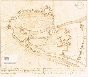
Luick, Leodium. Kleiner Befestigungsgrundriss von Lüttich an der Maas. Kupferstich in Rotdruck von Petrus Schenk, Amsterdam 1702
Petrus Schenk (1661-1711), deutscher Kupferstecher und Verleger in Amsterdam
Published by Amsterdam: Petrus Schenk im Selbstverlag mit Privileg der Vereinigten Staaten von Holland und Westfriesland, 1702
- First Edition
- Signed
- Map
Seller: historicArt Antiquariat & Kunsthandlung, Wiesbaden-Breckenheim, GermanyhistoricArt Antiquariat & Kunsthandlung
Contact seller5-star sellerCondition: Used
US$ 58.91
US$ 13.73 shippingShips from Germany to U.S.A.Quantity: 1 available
1. kleiner Original-Kupferstich in Rotdruck von Petrus Schenk (in der Platte signiert und datiert), mit Privilegiumsvermerk auf rückseitig unbedrucktem dicken Büttenblatt mit dekorativ abgesetztem Plattenrand, am oberen Rand Kompass,unterhalb der bildlichen Darstellung Text in Niederländisch und Lateinisch, bildliche Darstellung… ca. 14,5 x 18,5 cm, Blattgröße ca. 19 x 19,5 cm, geglättete Mittelfalz, ansonsten sehr gut erhalten, selten 2100 gr.
Language: English
- Hardcover
Seller: Terra Firma Books, San Diego, CA, U.S.A.Terra Firma Books
Contact seller5-star sellerCondition: Used - Very good
US$ 129.99
US$ 5.99 shippingShips within U.S.A.Quantity: 1 available
Hardcover. Condition: Very Good. Modern printing plate.Original published by Braun and Hogenberg in 1572 as a bird's eye view. This is a steel plate measuring 13 3/4B x 22 3/4" (35x58 cm). Bears the coat-of-arms of Bishop( later Cardinal) Gerard Van Groesbeck (1517-80).

Published by Francoforte, 1638
- Art Print
Seller: libreria antiquaria perini Sas di Perini, Verona, VR, Italylibreria antiquaria perini Sas di Perini
Contact seller5-star sellerCondition: Used
US$ 294.57
US$ 45.76 shippingShips from Italy to U.S.A.Quantity: 1 available
Incisione in rame, 240x330. Tratta da ìNeuwe Archontologia cosmicaî di Johann Gottfried. Buon esemplare. Nr.cat: Cod 4834.
- Hardcover
Seller: Xerxes Fine and Rare Books and Documents, Glen Head, NY, U.S.A.Xerxes Fine and Rare Books and Documents
Contact seller5-star sellerCondition: Used - Good
US$ 450.00
US$ 5.95 shippingShips within U.S.A.Quantity: 1 available
Condition: Good. Namurci 1639 Typis Ionnis van Milst. Hardcover. In Latin. Square octavo, (28), 643pp., (2), full vellum. Near Good, title page browned and soiled, vellum worn, two inch cut (not fully closed) on spine. Pictures available on request.

Condition: Used - Good
US$ 1,673.14
US$ 57.20 shippingShips from Spain to U.S.A.Quantity: 1 available
Condition: ACEPTABLE. Civitates Orbis Terrarum 1572/1617 Publicados entre 1572 y 1617, los seis volúmenes del Civitates Orbis Terrarum de Georg Braun y Franz Hogenberg Constituyen el primer Atlas de ciudades de todo el mundo en el que se representan vistas de pájaro y planos de las mismas. Formato (cm): 55x40.
Published by Cologne: T. Graminaeus, 1572-90., 1572
Seller: Arader Galleries - AraderNYC, New York, NY, U.S.A.Arader Galleries - AraderNYC
Contact seller5-star sellerSingle page (22 x 16 ½) Full margins showing the plate mark (foxing, browning, margin staining, chipping) The magnificently designed engraving of Liège takes up the rapturous tone of Braun's description and shows the city with the Meuse flowing in its favorable location amongst gentle hills, sturdy trees and fertile fields. Pres…ented in spatial depth and exuding a striking sense of animation, it is one of the most successful landscapes in Braun and Hogenberg's city atlas. In 1468, Liège was attacked by Charles the Bold and set alight, profoundly altering the medieval face of the city. From the second half of the 15th century onwards much of the city was rebuilt in the contemporary style. The illustration shows the Ourthe flowing into the Meuse and the concentration of buildings in the city centre with its soaring churches and hospices. The cathedral of Saint-Lambert, which would later be destroyed in the upheaval of the French Revolution, is impressively documented. The Gothic collegiate church of Saint-Paul was made Liège's new cathedral. Examples of Romanesque architecture include the collegiate churches of Saint-Denis, Saint-Barthélemy and the church of Saint-Martin, which was built in the Gothic style in the early 16th century. The 'Civitates Orbis Terrarum' ('Atlas of the Cities of the World') by Braun and Hogenburg is the second oldest printed atlas in the history of world cartography; and the first atlas of towns. Its principal creators and authors were the theologist and editor Georg Braun, the most important engraver and publisher Franz Hogenberg. Other artists involved were Simon van den Neuvel, Georg Hoefnagel, Jacob van Deventer to name a few. Although it was published outside of the Netherlands, the Civitates is considered one of the better examples of the Antwerp School of Cartographers, due to its Flemish style of engraving a trait typical of Dutch atlases from the period. One of the most well-known figures from this school, who also played a key role in the making of this atlas, was Abraham Ortelius. It is frequently thought that the Civitates is the direct and intended companion for Ortelius' famous 'Theatrum Orbis Terrarum' (1570). In addition to this, there is evidence of correspondence between these three great men and their ideas to create such an atlas. The first volume of the Civitates Orbis Terrarum was published in Cologne in 1572. Its sixth and final volume appeared later in 1617. The Civitates was a widespread and enormously successful. It was frequently republished and supplemented with new sections with later editions. The maps it contained became exemplary and references; thus often reproduced in smaller formats as illustrations for books by other publishers. The atlas bares over 500 maps, representing an entire era in the lavish history of town-mapping. Earlier collections of city views were heterogeneous productions, limited in scope, and often made no meaningful attempt to render the subjects with any degree of realism. The Civitates, by contrast, contained hundreds of views, including many of smaller towns for which no earlier representations are known, depicted with unprecedented accuracy. Braun corresponded extensively with map sellers and scholars from different cities and countries to achieve the highest level of accuracy in his mapping. In addition, the authors also carried out their own investigations, through detailed on-location drawings of panoramic views of the towns made from some high point. It took over forty years to collect the hundreds of plans contained in the Civitates. The plans, each accompanied by Braun's printed account of the town's history, situation and commerce, form a lavish armchair-traveler's compendium, and provide a uniquely comprehensive view of urban life at the turn of the sixteenth century. The significance of its being printed in Cologne extends to the city's independence of being a free imperial state. There were few cities which held thi.

Published by Matthäus Merian, 1646
- Map
Seller: Antiquariaat Dat Narrenschip, Middelburg, NetherlandsAntiquariaat Dat Narrenschip
Contact seller5-star sellerCondition: Used - Fine
US$ 294.57
US$ 30.89 shippingShips from Netherlands to U.S.A.Quantity: 1 available
No Binding. Condition: Fine. Antique city map of Liège. Backside blank. Hand-coloured copper engraving by Matthäus Merian, published in Frankfurt in 1646 in 'Neuwe Archontologia Cosmica, das ist Beschreibung aller Kayserthumber Konigreichen und Republicken der gantzen Welt,' Johann Ludwig Gottfried. Dimensions (image): 29 x 38 c…m.
 More images
Published by Georg Braun & Frans Hogenberg, 1572
- Map
Seller: Antiquariaat Dat Narrenschip, Middelburg, NetherlandsAntiquariaat Dat Narrenschip
Contact seller5-star sellerCondition: Used - Fine
US$ 624.48
US$ 30.89 shippingShips from Netherlands to U.S.A.Quantity: 1 available
No Binding. Condition: Fine. Antique print of Liège. Title above. Legend bottom right. Latin text on the back. Hand-coloured copper engraving, published in Cologne in 1572 in "Civitates Orbis Terrarum," Georg Braun and Frans Hogenberg. First edition (without privilege). Dimensions (image): 33 x 48 cm.

- Map
Seller: Geographicus Rare Antique Maps, Brooklyn, NY, U.S.A.Geographicus Rare Antique Maps
Contact seller4-star sellerVery good. Marginal waterstains, entering image at right. Areas of toning. Old marginal extension to left, not impacting printed image. Beautiful original color. Size 17.25 x 31.5 Inches. This large, detailed, and ornate bird's-eye view style map of Liege, Belgium, was produced by Joan Blaeu in 1649 for inclusion in his city atl…as of the Netherlands. A Closer Look A numbered key to 250 locations appears in a table at the bottom of the engraving. Four coats of arms surmount the view: those of the Prince-Bishop of Liege, the Holy Roman Empire, Liege's Archbishop Maximilian Henry of Bavaria, and the city of Liege itself. Dominating the center of the view (and receiving the honor of number 1 in the list) is the Grand Cathedral of Our Lady and St. Lambert. When French Revolutionary forces captured the city in 1794, the French Revolutionary Army destroyed the Cathedral as an aristocratic symbol of the prince-bishop. One prominent feature of the city's topography is a sharp oxbow on the Meuse, La Sauvenière . By the end of the 18th century, La Sauvenière had become stagnant and unsanitary. Starting in 1808, the canal was gradually filled - predominantly with debris from the Cathedral of Our Lady and St. Lambert. It was turned into a canal and a promenade beginning in the 1820s, and in 1844, it was entirely filled. Today, it has been paved over by the Boulevard de la Sauvenière, otherwise known as the N617a. Publication History This map was engraved by Julius Milheuser for inclusion in Joan Blaeu's Novum ac Magnum Theatrum Urbium Belgicae Regiae , first appearing in the 1649 Latin edition of the book (as is the case with this example). A later state, with De Wit's imprint, has been recorded. Three separate examples are listed in OCLC. Scarce on the market. References: OCLC 776691916. Koeman, C. Atlantes Neerlandici, V. I, p. 295 -323.

Language: German
- Art Print
Seller: Antiquariat Clemens Paulusch GmbH, Berlin, GermanyAntiquariat Clemens Paulusch GmbH
Contact seller5-star sellerCondition: Used
US$ 88.37
US$ 51.48 shippingShips from Germany to U.S.A.Quantity: 1 available
Holzschnitt aus Romanus ( Städtebuch ), 1595, 6,7 x 9,4.

Language: German
- Art Print
Seller: Antiquariat Clemens Paulusch GmbH, Berlin, GermanyAntiquariat Clemens Paulusch GmbH
Contact seller5-star sellerCondition: Used
US$ 206.20
US$ 51.48 shippingShips from Germany to U.S.A.Quantity: 1 available
Kupferstich v. G. Bodenehr, um 1730, 16,5 x 48.

Language: German
- Art Print
Seller: Antiquariat Clemens Paulusch GmbH, Berlin, GermanyAntiquariat Clemens Paulusch GmbH
Contact seller5-star sellerCondition: Used
US$ 471.31
US$ 51.48 shippingShips from Germany to U.S.A.Quantity: 1 available
Kupferstich v. Johann Christian Leopold n. F. B. Werner, um 1730, 19 x 28 Marsch, Friedrich Bernhard Werner, S. 158 ff. ( = Stadtansichten aus dem Verlag Leopold, Nr. 108) - Hier vorliegend aus der 1. Auflage im 1. Zustand vor der Nummerierung ). - Im Himmel Spruchband mit Titel, rechts und links davon 2 Putti mit Erklärugen von… 1 - 55). Unter der Ansicht Stadtbeschreibung in lat. u. deutscher Sprache, mittig das Stadtwappen.
Seller: Antiquariat Schmetz am Dom, Aachen, GermanyAntiquariat Schmetz am Dom
Contact seller5-star sellerCondition: Used
US$ 235.65
US$ 68.64 shippingShips from Germany to U.S.A.Quantity: 1 available
0. Ca 22 x 33.5 cm. Gerahmt. Mittig schwach Faltspur, im unteren weißen Rand dort kl. Einriß. Es handelt sich um die begehrtere Vedute aus der Kavaliersperspektive, nicht um das Blatt aus der Vogelschausicht. Sprache: Deutsch.


