
Order Total (1 Item Items):
Shipping Destination:

Manila Map, Used (25 results)
Skip to main search results
Search filters
Product Type
- All Product Types
- Books (8)
- Magazines & Periodicals (No further results match this refinement)
- Comics (No further results match this refinement)
- Sheet Music (No further results match this refinement)
- Art, Prints & Posters (6)
- Photographs (No further results match this refinement)
- Maps (10)
- Manuscripts & Paper Collectibles (1)
Condition Learn more
- New (No further results match this refinement)
- As New, Fine or Near Fine (1)
- Very Good or Good (12)
- Fair or Poor
- As Described (12)
Binding
Collectible Attributes
- First Edition (3)
- Signed (No further results match this refinement)
- Dust Jacket (No further results match this refinement)
- Seller-Supplied Images (21)
- Not Print on Demand (25)
Language (4)
Free Shipping
- Free Shipping to U.S.A. (No further results match this refinement)
Seller Location
Seller Rating
-

Manila Map (Nelles Maps)
Seller: WorldofBooks, Goring-By-Sea, WS, United Kingdom
Seller rating 5 out of 5 stars

Paperback. Condition: Very Good. The book has been read, but is in excellent condition. Pages are intact and not marred by notes or highlighting. The spine remains undamaged.
-
-
TOURIST MAP. CITY OF MANILA
Published by Philippine Travel Information Office, Manila
Seller: Complete Traveller Antiquarian Bookstore, Westport, CT, U.S.A.
Association Member: IOBA SNEAB
Seller rating 5 out of 5 stars
US$ 30.00 15% offUS$ 25.50
US$ 4.99 shipping
Ships within U.S.A.Quantity: 1 available
Add to basketHardcover. Condition: Very Good. Light edgewear along the folds. Small note on map. Slight browning to paper. ; A tourist map in color. Back side with a legend, tips to visitors and facts on Manila. Nd [1960's] ; Narrow 8vo 8" to 9" tall.
-

Condition: Muy bueno. : Mapa tur�stico de Manila, Filipinas, publicado por Nelles Verlag. Incluye informaci�n detallada de la ciudad, sus calles y puntos de inter�s. Ideal para viajeros que deseen explorar Manila de forma independiente. EAN: 9783886185474 Tipo: Libros Categor�a: Otros T�tulo: Nelles Manila Map Autor: Nelles Verlag Formato: tapa blanda.
-
1894 Map of Manila Bay and its surrounding areas in the Philippines
Published by Meyers Konversations
Seller: Artisans-lane Maps & Prints, Sidney, BC, Canada
Seller rating 4 out of 5 stars

Art / Print / Poster
no binding. Condition: very good. Approximate Overall Size: 6 X 9 1/2 inches . Actual map Size: 5 x 3 1/2 ins. CONDITION: Excellent Condition. As Scanned. German Text. Beautiful with excellent detail. Single page Print with text on the back. Manila Bay and its surrounding areas in the Philippines, featuring various labels including the names of towns, bodies of water, and other geographical features. Some interesting features found on the map include Manila, the capital city of the Philippines; Corregidor Island, an island located at the entrance of Manila Bay that formerly housed important fortifications; Cavite, a province located on the southern shore of Manila Bay; and Laguna de Bay, a large freshwater lake located east of Manila. The scale of the map is provided at the bottom left and right corners, reading "Scale 1:876000" and "Scale 1:88000", which translates to "scale 1:876,000" and "scale 1:88,000" respectively. NOTE THE FOLLOWING BEFORE YOU PURCHASE: This is a GENUINE ANTIQUE PRINT. It is NOT a modern reproduction, ie. a laser scan, photocopy etc. It is the original from the antique atlas or book publication. This map/print was published on the date mentioned, or circa of the date mentioned at the top of the page. The print/map I have for sale, like many antique maps and prints that you see online, originate from an antique book or atlas publication. The publication may not always be known. If you have any questions, emails are welcome.
-
MANILA MAP
Published by T. R. P. Ltd. Switzerland
Seller: Complete Traveller Antiquarian Bookstore, Westport, CT, U.S.A.
Association Member: IOBA SNEAB
Seller rating 5 out of 5 stars
Map
US$ 40.00 15% offUS$ 34.00
US$ 4.99 shipping
Ships within U.S.A.Quantity: 1 available
Add to basketMap. Condition: Very Good+. A large fold-out map in bold colors: Yellow, pink, green and orange. Nd. [1970's? ]. ; 8vo 8" - 9" tall.
-

Historical map of the Manila area in the Philippines,1890s Print
Published by Meyers Konversations
Seller: Artisans-lane Maps & Prints, Sidney, BC, Canada
Seller rating 4 out of 5 stars
Art / Print / Poster First Edition
no binding. Condition: very good. Approximate Overall Size: 6 X 9 1/2 inches - Print Area: 5 x 3 inches. CONDITION: - Excellent Condition. As Scanned. German Text. Beautiful with excellent detail. Single Page ,Blank on the Back. This is a map of the Manila area in the Philippines, with labels in German. The map shows various geographical features such as bodies of water, cities, towns, and landmarks. Some of the major cities and towns labeled on the map include Manila, Malabon, Pandan, Orion, and Mariveles. The map also shows the location of a leprosy hospital and a new harbor. The map includes a scale of 1:875,000 and indicates that it is the 1st edition. NOTE THE FOLLOWING BEFORE YOU PURCHASE: This is a GENUINE ANTIQUE PRINT. It is NOT a modern reproduction, ie. a laser scan, photocopy etc. It is the original from the antique atlas or book publication. This map/print was published on the date mentioned, or circa of the date mentioned at the top of the page. The print/map I have for sale, like many antique maps and prints that you see online, originate from an antique book or atlas publication. The publication may not always be known. If you have any questions, emails are welcome.
-
Manila, on the western side of Luzon island in the Philippines,1800s Antique Map and City Plan
Published by Reclus
Seller: Artisans-lane Maps & Prints, Sidney, BC, Canada
Seller rating 4 out of 5 stars
Art / Print / Poster
no binding. Condition: very good. ACTUAL MAP IMAGE SIZE: 5 1/2 x 4 1/2 ins. OVERALL SIZE including text and borders : 10 1/2 x 7 Ins . CONDITION: This is a Intext map with text on the back. Clear and sharp with beautiful detail. As scanned. NOTE THE FOLLOWING BEFORE YOU PURCHASE: This is a GENUINE ANTIQUE VINTAGE 1890 MAP. It is NOT a modern reproduction, ie. a laser scan, photocopy etc. It is the original from the antique or vintage atlas or book publication. This intext map was published on the date mentioned, or circa of the date mentioned at the top of the page. The map I have for sale, like many antique vintage prints and maps that you see online, originate from an antique vintage book or atlas publication. The publication may not always be known. If you have any questions, emails are welcome.
-
The Environs of Manila, on the western side of Luzon island in the Philippines,1800s Antique Map
Published by Reclus
Seller: Artisans-lane Maps & Prints, Sidney, BC, Canada
Seller rating 4 out of 5 stars
Art / Print / Poster
no binding. Condition: very good. ACTUAL MAP IMAGE SIZE: 5 x 4 ins. OVERALL SIZE including text and borders : 10 1/2 x 7 Ins . CONDITION: This is a Intext map with text on the back. Clear and sharp with beautiful detail. As scanned. NOTE THE FOLLOWING BEFORE YOU PURCHASE: This is a GENUINE ANTIQUE VINTAGE 1890 MAP. It is NOT a modern reproduction, ie. a laser scan, photocopy etc. It is the original from the antique or vintage atlas or book publication. This intext map was published on the date mentioned, or circa of the date mentioned at the top of the page. The map I have for sale, like many antique vintage prints and maps that you see online, originate from an antique vintage book or atlas publication. The publication may not always be known. If you have any questions, emails are welcome.
-
1894 Map of Manila Bay and its surrounding areas in the Philippines
Published by Meyers Konversations
Seller: Artisans-lane Maps & Prints, Sidney, BC, Canada
Seller rating 4 out of 5 stars
Art / Print / Poster
no binding. Condition: very good. Approximate Overall Size: 6 X 9 1/2 inches . Actual map Size: 5 x 3 1/2 ins. CONDITION: Excellent Condition. As Scanned. German Text. Beautiful with excellent detail. Single page Print with text on the back. Manila Bay and its surrounding areas in the Philippines, featuring various labels including the names of towns, bodies of water, and other geographical features. Some interesting features found on the map include Manila, the capital city of the Philippines; Corregidor Island, an island located at the entrance of Manila Bay that formerly housed important fortifications; Cavite, a province located on the southern shore of Manila Bay; and Laguna de Bay, a large freshwater lake located east of Manila. The scale of the map is provided at the bottom left and right corners, reading "Scale 1:876000" and "Scale 1:88000", which translates to "scale 1:876,000" and "scale 1:88,000" respectively. NOTE THE FOLLOWING BEFORE YOU PURCHASE: This is a GENUINE ANTIQUE PRINT. It is NOT a modern reproduction, ie. a laser scan, photocopy etc. It is the original from the antique atlas or book publication. This map/print was published on the date mentioned, or circa of the date mentioned at the top of the page. The print/map I have for sale, like many antique maps and prints that you see online, originate from an antique book or atlas publication. The publication may not always be known. If you have any questions, emails are welcome.
-
Luzon Island Philippines Manila Makati Vigan Pasay 1904 detailed map
Publication Date: 1904
Seller: RareMapsandBooks, Dover, NH, U.S.A.
Seller rating 4 out of 5 stars
Map
Condition: good. Island of Luzon.(Old Maps, Early 20th Century Maps, Asia, Southeast Asia, Philippines, Luzon Island, Manila, Makati, Vigan, Pasay). Issued 1904, Chicago by George Cram. Early 20th century color lithographed map. Well preserved, nice looking example with pleasing age patina. Sheet Measures c. 14 1/2" H x 11" W. Engraved Area Measures c. 13 1/2" H x 10 1/2" W. Cartographic Reference (s):Tooley's Dictionary of Mapmakers, vol. 1.[R32388].
-
Celebes & Philippines Manila Indonesia Flores Islands Timor 1958 Bartholomew map
Publication Date: 1958
Seller: RareMapsandBooks, Dover, NH, U.S.A.
Seller rating 4 out of 5 stars
Map
Condition: good. Celebes Philippines.(Old Maps, 20th Century Maps, Asia, Indonesia, Celebes, Flores Islands, Philippines, Manila). Issued 1958, Edinburgh by John Bartholomew & Son for the Geographic Institute. Mid 20th century color folio sheet color lithographed map. A large oversized map with a remarkable level of detail capturing this area shortly after the Second World War. The scale of the map makes it particularly interesting to those looking for more detail than typically seen on commercial American produced maps of this era. The key locates "main civil airports" as well as oil pipe lines, flood areas and active volcanoes. Well preserved, clean, nice looking example with pleasing age patina. Original center fold as issued. Sheet Measures c. 19 1/4" H x 24" W. Engraved Area Measures c. 17" H x 22" W. Cartographic Reference (s):Tooley's Dictionary of Mapmakers, vol. 2.[R31386].
-
Race to Manila, Philippines, 1941 / 1942 - 1967 Vintage WW2 Map
Seller: Staffordshire Curios, Haughton, United Kingdom
Seller rating 2 out of 5 stars

Art / Print / Poster
US$ 21.83
US$ 19.80 shipping
Ships from United Kingdom to U.S.A.Quantity: 1 available
Add to basketOriginal Vintage map extracted from a 1967 print of Reports of General MacArthur Japanese Operations in The Southwest Pacific AreaMap is in good condition, with some general light handling wear with age but nothing major, see photo. Please note print is double sided with text to the reverse. Slight light wavyness to sheet with age and a slight light bump to top right corner.Approx total paper size is 30 x 22.5cmSee photo; 8vo 8" - 9" tall.
-

Indexed pocket map of the Philippine Islands with two inset maps on a larger scale showing Manila and the intervening country between Dagupan and Manila.
Published by Rand McNally & Company,, Chicago e New York,, 1910
Seller: La Darsena di Leonelli Siro e C. s.a.s., Modena, MO, Italy
Seller rating 1 out of 5 stars

Carta geografica rip. entro br. edit., dimensioni cm. 53,5 x 72. Bella carta a colori, molto dettagliata, con inserti di particolari su Manila e il territorio tra Manila e Dagupan. Ottima conservazione.
-
Southeast Asia Malaysia Indonesia Philippines Jakarta Manila 1855 Dufour map
Publication Date: 1855
Seller: RareMapsandBooks, Dover, NH, U.S.A.
Seller rating 4 out of 5 stars
Map
Condition: good. Carte de la Malaisie.(Old Maps, 19th Century Maps, Asia, Southeast Asia, Malaysia, Indonesia, Sumatra, Java, Borneo, Celebes, Philippines, Jakarta, Manila). Issued 1855, Paris, by A. H. Dufour. Mid-19th century engraved map, with lovely original hand color. Nice looking example, pleasing age patina, any minor age flaws easy to overlook or forgive. Original center fold as issued. Sheet Measures c. 11 1/2" H x 15 1/2"W. Engraved Area Measures c. 9 1/2" H x 12 1/2" W. Cartographic Reference (s):Tooley's� Dictionary of Mapmakers, vol. 1, pp. 396.[R31130].
-
Luzon Manila Cavite Bataam Philippines Filipinas 1900 large color detail map
Publication Date: 1900
Seller: RareMapsandBooks, Dover, NH, U.S.A.
Seller rating 4 out of 5 stars
Map
Condition: good. No. 9 - Luzon.(Old Maps, 20th Century Maps, Asia, Southeast Asia, Philippines, Luzon, Manila, Cavite, Bataam). Issued 1900, Baltimore by Hoen & Co, Lithographic printers for the U. S. Coast & Geodetic Survey. Large turn of the 20th century color lithographed map relating to these islands. Nice level of detail including topography. Key notes further features. Well preserved, clean, nice looking example with pleasing age patina, any age flaws very small and minor in the blank margins or along edges. Sheet Measures c. 14 1/2" x 12 3/4". Printed Area Measures c. 13 1/2" x 11 3/8".[R33448].
-

"Plan de la Baye de Manille." / "Plan du Port de Acapulco." - Manila Philippines Philippinen Bay Acapulco Mexico Karte map
Language: French
Published by Paris, 1787
Seller: Antiquariat Steffen V�lkel GmbH, Seubersdorf, Germany
Seller rating 5 out of 5 stars
Map
Sehr seltene Kupferstich-Karte von Philippe de Pretot aus seinem Atlas Universelle aus dem Jahre 1787. -- Blatt-Ma�e: ca. 33,5 x 49 cm. -- gut erhalten. || Very rare copper engraved map by Philippe de Pretot out of his Atlas Universelle from 1787. -- in good condition. || Dies ist ein Original! - Kein Nachdruck! - Keine Kopie! | This is an original! - No reprint! - No copy! // Wir, das Antiquariat Steffen V�lkel, kaufen und verkaufen alte B�cher, Handschriften, Zeichnungen, Autographen, Grafiken und Fotografien. Wir sind stets am Ankauf von kompletten Bibliotheken, Sammlungen und Nachl�ssen interessiert. Sprache: Franz�sisch Gewicht in Gramm: 1500.
-
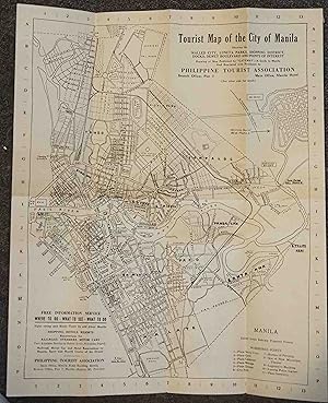
Tourist Map of the City of Manila
Published by Manila c.1935-1940, Manila, 1935
Seller: High Ridge Books, Inc. - ABAA, South Deerfield, MA, U.S.A.
Association Member: ABAA ESA ILAB SNEAB
Seller rating 5 out of 5 stars
43x35 cm., folds to 21.5x8.75 cm. Uncolored map of Manila on verso, promotional and descriptive text on recto. 11 location key, but also Identifies many other buildings and important locations. While undated, this almost certainly dates from 1935-1940, during the period of United States occupation. but before World War II. Many of the locations identified here would have been destroyed by the war or renamed after it.
-
[ANNUAL REPORT OF MAJOR GENERAL E.S. OTIS, U.S. VOLUNTEERS, COMMANDING DEPARTMENT OF THE PACIFIC AND EIGHTH ARMY CORPS, MILITARY GOVERNOR IN THE PHILIPPINE ISLANDS. With:] OFFICE OF CHIEF SIGNAL OFFICER DEPT OF PACIFIC & 8th A.C. MAP OF THE OPERATIONS AGAINST MANILA AUG. 13, 1898.
Published by Manila. 1899; 1898., 1899
Seller: William Reese Company, New York, NY, U.S.A.
Association Member: ABAA ESA ILAB SNEAB
Seller rating 5 out of 5 stars
First Edition
An excellent association copy of the scarce Manila printing of Military Governor E.S. Otis's report on the first year of the Philippine-American War, with a rare blueprint map of the capture of Manila. This copy was owned by Major General Thomas M. Anderson, commander of the assault on Manila which ended the Spanish-American War, as well as an officer in the Battle of Manila which kicked off the following year's conflict. Otis's report was submitted in August of 1899, and thus covers the year immediately following the capture of Manila from the Spanish, including the failed annexation, rapid breakdown of U.S.-Philippines relations, and reopening of hostilities. Despite the former allying with the Filipino revolutionary faction under Emilio Aguinaldo, who declared independence and drafted a constitution in late 1898, neither the Americans nor the Spanish recognized the independent islands in their negotiations for the end of the Spanish-American War, instead annexing the Philippines to the United States. The first few months of Otis's report largely focus on questions of muddled ownership, taxation, customs enforcement, and the legal rights of the American occupation. By November he already writes about efforts to suppress "seditious" Filipino newspapers, though the key turning point was the attempted landing of occupation forces at Iloilo in late December. The orders issued to Brig. Gen. Marcus Miller are printed here, stating that he is to be "conciliatory but firm" in his duty, noting that "a new provisional cabinet has been formed [in Manila], hostile to the American annexation.These men are closely watching the results of your expedition and greatly hope that you will be obliged to use force to gain Iloilo." In the tense weeks that followed, Aguinaldo and the Filipino government issued proclamations vowing to resist American pretensions of sovereignty with armed force if pushed, and the first casualties of the Philippine-American War were recorded when an American soldier opened fire on February 4, 1899. The reports in the present document paint a fascinating and detailed picture of the confused American response to the rapidly deteriorating relations with their former allies, and of similarly deteriorating attitudes: in the tone of their reports, officers plainly cease to view their adversaries as meek natives to be "civilized," describing them instead as untrustworthy and bloodthirsty savages after they refused to politely roll over. General Anderson, who in command of a sizable force at the beginning of the war, is mentioned a number of times in these documents. His name is often underlined or otherwise highlighted, such as a particularly noteworthy mention on p.163, when his unit was permitted to launch the first formal attack against Filipino forces on February 5. Accompanying this copy of Otis's reports is an impressive blueprint map of the 1898 capture of Manila, possibly handcolored by Anderson or the drafter himself. The map, prepared by Sergeant J.H. Watkins of the Signal Corps in October 1898, depicts the lines of American entrenchments, insurgent forces (allied with the Americans in this instance), and of course the Spanish. Special attention is paid to the challenging terrain, with symbols representing "Swamp (Rice and Overflow)," "Jungle (Bamboo and other Tropical Undergrowth)," roads, churches, and telegraph lines. Anderson is the first named commanding officer on the map, and the map's compilers were members of his unit. Thomas McArthur Anderson (18361917) was a lawyer at the outbreak of the Civil War, when he enlisted in the 6th Ohio Volunteer Infantry with the encouragement of his uncleRobert Anderson, the commanding officer of Fort Sumter. He was promoted to lieutenant colonel by 1864, and remained in the service. He was notably posted to Dyea, Alaska, at the beginning of the Klondike Gold Rush in 1898, before being promoted and given command of the first "Philippine Expeditionary Force" when war broke out with Spain. He landed on Luzon in June, played an instrumental role in the capture of Manila, and was still present for the first battle between Aguinaldo's government and American forces in 1899. He retired in January 1900, returning to his birth state to take charge of the Ohio Soldiers Home. A pair of rare and revealing documents, with important provenance. This first edition of Otis's reports, printed in Manila, is recorded at fewer than ten institutions on OCLC. It was printed with a wrapper title but no titlepage and was supplemented by a separately printed volume of appendices, not present here. Another edition, differently paginated and with an altered titlepage, was printed shortly afterwards in the Government Printing Office. A significantly smaller, non-blueprint version of Watkins's map is recorded at Yale and in the War Department Map Collection at the National Archives, but we locate no other copy of this larger (original?) blueprint version. OCLC 13196031, 68180445, 81872167, 237793063, 13196031, 68886550. Three-quarter blue diced russia and patterned black silk boards, spine gilt. Spine heavily sunned, corners rubbed. Manuscript note describing provenance on front free endpaper, occasional underlining and annotations in black or purple ink, else internally fine. Map trimmed unevenly but with ample margins on all sides, small closed tears and chips to edges, a few just into printed border.
-
Map of the City of Manila and Vicinity.
Published by c.1901, Washington DC, 1901
Seller: Alexandre Antique Prints, Maps & Books, Toronto, ON, Canada
Seller rating 4 out of 5 stars
Map
Size : 731x544 (mm), 28.78x21.42 (Inches), Hand Colored Very Good, backed on acid free tissue paper for long term preservation.
-

Table and Pocket Map Guide City of Manila Republic of the Philippines.
Publication Date: 1960
Seller: Geographicus Rare Antique Maps, Brooklyn, NY, U.S.A.
Association Member: ABAA ESA ILAB
Seller rating 4 out of 5 stars
Map
Very good. Wear along original fold lines. Printed photographs on verso. Size 15.5 x 13.5 Inches. This is a 1960 Domingo de Jesus city plan or map of Manila, Philippines. Districts are labeled throughout the city, including Intramuros, as are streets, parks, railroad stations, and universities. United Nations Park, situated near south Manila Bay, is prominently illustrated, as is the U.S. Embassy, the University of Philippines, and Philippine General Hospital. Thirty-seven locations across the city are numerically identified and correspond with an index situated in the upper right corner. A photograph of the Monument of the National Hero of the Philippines Dr. Jose P. Rizal is printed in the lower right corner. Publication History This map was created and copyrighted by Domingo D. de Jesus and published in two editions. This is an example of the second edition, published in 1960.
-

Complimentary Map of the City of Manila Prepared under the Direction of the Engineer. Phil. Dept. U.S. Army 1935. Corrected to 1938.
Publication Date: 1938
Seller: Geographicus Rare Antique Maps, Brooklyn, NY, U.S.A.
Association Member: ABAA ESA ILAB
Seller rating 4 out of 5 stars
Map
Very good. Slight toning on left side of map, small area of discoloration inrightmargin. Creasing along fold lines and uneven toning on verso. Size 14.5 x 17.5 Inches. A detailed 1938 city plan or map of Manila in the Philippines from the Commonwealth period issued by the Manila Branch of the Army-Navy Y.M.C.A. It reflects the city's complex identity and history, strongly influenced by Spanish and then American colonial presence. A Closer Look An alphanumeric grid surrounds the map, corresponding to lists of principal points of interest and main roads at top and bottom-right. A more complete index of streets appears on the verso. Numbers refer to U.S. Army bases and other facilities ('reservations') listed at bottom-left, while red markers indicate the location of Y.M.C.A.s, including the main Army-Navy Y.M.C.A. in Intramuros, the city's historic center. City districts, such as Binondo, the 'world's oldest Chinatown,' and major public institutions, such as the distinctive Bilibid Prison complex (now the Manila City Jail), are indicated. Red text surrounds the map, advertising the goods of the Hamilton-Brown Shoe Store and Haberdashery. The verso includes a complete map of the Philippines, marking out Army-Navy Y.M.C.A. locations (often on military bases), along with basic information about the islands and a table of distances. As a whole, the map demonstrates the heavy presence of U.S. military personnel in the Philippines at the time, in part a legacy of U.S. colonialism, but more so a reaction to concerns about Japan's growing military threat to the islands, a threat which became apparent when Japan invaded only three years later. In February-March 1945, Manila was subjected to widespread destruction and devastation as Japanese troops desperately tried to hold back American and Filipino forces. The Burnham Plan for Manila Parts of Manila as seen here reflect the designs of Thomas Burnham, better known for his grand urban plans of cities in the continental U.S. (including his mostly unrealized plan for San Francisco). In 1904, Burnham developed a plan for the city on a commission from Governor-General William Howard Taft after spending only six weeks in the Philippines (he also designed the 'summer capital' of Baguio). Typical of his Beaux-Arts style, Burnham emphasized grand government buildings, wide boulevards, and public sanitation. The majority of Burnham's vision was not enacted, but elements were constructed, especially in Ermita District, including Burnham Green, just above the title. The Philippines Move Toward Independence This map was produced soon after the Philippines transitioned from a quasi-colonial government with an appointed American Governor to a relatively autonomous Commonwealth under Filipino elites. Although society was highly unequal, President Manuel L. Quezon (1878 - 1944) aimed to address inequalities with a range of policies, from land reform to infrastructure development and government involvement in industry. These measures were both popular and effective, spurring the Philippine GDP to grow steadily despite a weak global economy. Nonetheless, the Second World War sidelined many of Quezon's projects and the man himself died in exile before the war ended. Publication History and Census This map was published by the Army-Navy Y.M.C.A. in 1938, amended from a 1935 map produced by the U.S. Army. The only known example of this map in institutional collections is in the Richard Adlard collection at the Smithsonian Institution.
-

Table and Pocket Map Guide City of Manila Republic of the Philippines.
Publication Date: 1958
Seller: Geographicus Rare Antique Maps, Brooklyn, NY, U.S.A.
Association Member: ABAA ESA ILAB
Seller rating 4 out of 5 stars
Map First Edition
1st Edition. Good. Wear along original folds. Some loss at junctions of folds. Several small tears professionally repaired. Text and images on verso. Size 18.75 x 16.5 Inches. A scarce folding city plan or map of Manila, the capital of the Philippines, prepared by Domingo de Jesus and published by J.M. Azucena Publishing in 1958. A Closer Look Presented in an interesting cyanotype style, with white against a blue background, districts are labeled throughout, including the historic walled city of Intramuros, as are streets, parks, railroad stations, and universities. United Nations Park, situated near south Manila Bay, is prominently illustrated, as is the U.S. Embassy, the University of the Philippines, and the Philippine General Hospital. Thirty-seven locations across the city are numerically identified and correspond with an index in the upper right corner. A photograph of the Monument of the National Hero of the Philippines, Dr. Jose P. Rizal, is printed in the lower right corner. The verso includes photographs of several locations identified on the recto, including the Legislative Building, City Hall, and the Army and Navy Club. The prominence of American military, diplomatic, and cultural institutions suggests the map may have been intended for American visitors and residents of the city. Rebuilding the 'Pearl of the Orient' Before World War II, Manila was a bustling, cosmopolitan city with impressive amenities, earning it the nickname 'the Pearl of the Orient.' However, World War II took a serious toll on the city. Although it was not heavily damaged by the Japanese invasion of late 1941 and early 1942, the Japanese fought tooth and nail to defend the city in early 1945. Manila was almost completely destroyed (only Warsaw saw worse destruction during the war), and at least 100,000 civilians were killed in the crossfire and a series of war crimes committed by Japanese troops. After a period of basic reconstruction, the city emerged from the horrific destruction of the war into a 'golden age' lasting from the 1950s to the 1980s. Three successive mayors - Arsenio Lacson, Antonio Villegas, and Ramon Bagatsing - are credited with ushering Manila through a period of rapid urbanization and economic growth, focusing on infrastructure and modernization, giving the city its modern form. Publication History and Census This map was prepared by Domingo D. de Jesus and published by J.M. Azucena Publishing. The present example is the first edition of the map, published in 1958. Additional editions were published in 1960, 1964, and 1967, all of which are quite rare. The OCLC only notes one example of this first edition, held by Pennsylvania State University, with later editions held by the Library of Congress, the National Library of Scotland, and the National Library of Australia. References: OCLC 55726496, 1417317636 (1967 edition).
-

Antique Map of the Bay of Manila, Capital of the Philippines, 1763
Seller: Bartele Gallery - The Netherlands, Langweer, FRL, Netherlands
Seller rating 5 out of 5 stars
Antique map titled 'Abzeichnung des Meerbusens bey Manila'. Map of the Bay of Manila, capital of the Philippines. This map originates from a German edition of 'Voyage around the World' by Lord George Anson. Published 1763.
-

Antique Engraved Map of Manila, the Earliest Obtainable Map of Manila Bay, 1726
Seller: Bartele Gallery - The Netherlands, Langweer, FRL, Netherlands
Seller rating 5 out of 5 stars
US$ 1,818.37
US$ 19.43 shipping
Ships from Netherlands to U.S.A.Quantity: 1 available
Add to basketAntique map titled 'Manilhas Bay'. This map is considered the earliest obtainable map of Manila Bay. Depicts Manila Bay, locating the city of Manila, Castle (Cabitta), Cloister of San Lucas, Cloister of Santa Domingo, and unnamed Cloister and numerous other geographical features. This map originates from 'Oud en Nieuw Oost-Indi�n' by F. Valentijn. Artists and Engravers: Fran�ois Valentijn (1666-1727), a missionary, worked at Amboina from 1684 to 1694 and 1705 to 1713 and travelled extensively in the VOC's lands. Artist: Fran�ois Valentijn (1666-1727), a missionary, worked at Amboina from 1684 to 1694 and 1705 to 1713 and travelled extensively in the VOC's lands. Condition: Very good, few tiny holes. Minor foxing and age-related toning. Please study image carefully. Date: 1726 Overall size: 40m x 34 cm. Image size: 38 x 20 cm.


![Seller image for [ANNUAL REPORT OF MAJOR GENERAL E.S. OTIS, U.S. VOLUNTEERS, COMMANDING DEPARTMENT OF THE PACIFIC AND EIGHTH ARMY CORPS, MILITARY GOVERNOR IN THE PHILIPPINE ISLANDS. With:] OFFICE OF CHIEF SIGNAL OFFICER DEPT OF PACIFIC & 8th A.C. MAP OF THE OPERATIONS AGAINST MANILA AUG. 13, 1898. for sale by William Reese Company](https://pictures.abebooks.com/inventory/md/md32464969522.jpg)