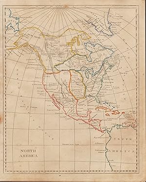
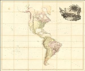
Map America by Arrowsmith Aaron (13 results)

Language: English
Published by Longman, Hurst, Rees & Orme, Paternoster Row, London 1809
- First Edition
- Map
Seller: THOMAS RARE BOOKS, Yaxley, SUFFOLK, United KingdomTHOMAS RARE BOOKS
Contact seller4-star sellerCondition: Used - Fine
US$ 448.81
US$ 20.11 shippingShips from United Kingdom to U.S.A.Quantity: 1 available
No Binding. Condition: Fine. 1st Edition. Original early 19th century uncoloured MAP OF BRITISH POSSESSIONS IN NORTH AMERICA BY AARON ARROWSMITH. A FINE, CLEAN AND DARK IMPRESSION. Original folding plate including Northern United States and gREENELAND DOWN TO WASHINGTON IN THE SOUTH. A scarce example and in fine un-coloured orig…inal condition.41x27cms. Double-page.
Published by Ford Graphics, Portland, OR 2001
- Softcover
Seller: Terra Firma Books, San Diego, CA, U.S.A.Terra Firma Books
Contact seller5-star sellerCondition: Used - Very good
US$ 1,400.00
US$ 5.99 shippingShips within U.S.A.Quantity: 1 available
Soft cover. Condition: Very Good. A superbly executed color FACSIMILE of the map that Lewis & Clark brought with them on their expedition.measures approx. 150 x 60 inches. Printed on canvas. Limited only to 20 some copies.
Published by London: A. Arrowsmith, 1796, Additions 1802 [but, After 1808]. 1808
- Hardcover
Seller: Arader Galleries - AraderNYC, New York, NY, U.S.A.Arader Galleries - AraderNYC
Contact seller5-star sellerHardcover. Fine folding engraved wall map in four separate sheets mounted on cartographic linen (each 25 x 29 inches), each in 15 sections, with EXCEPTIONALLY FINE AND DELICATE ORIGINAL HAND-COLOUR IN FULL, and decorated with a large and fine vignette of Niagara Falls lower right (some light browning and offsetting); original bl…ue paper boards slipcase (quite worn at extremities), title on printed paper label on front cover, and sectional titles on printed labels on verso of each section. Provenance: with the contemporary mapseller's label of C. Smith of the Strand on the verso of one section. AN EXCEPTIONALLY FINE EXAMPLE OF ARROWSMITH'S IMPORTANT MAP of America, first issued 1796, this is the second edition with Additions to 1802, third issue with Arrowsmith's address given as "10 Soho Square", and Arrowsmith is now styled "Hydrographer to H.R.H. the Prince of Wales". The 1802 edition is the last of Arrowsmith's large American maps to be issued before the Louisiana Purchase and it is known that Thomas Jefferson ordered himself a copy at about the same time as the Louisiana Purchase in 1803. It is also the edition that Lewis and Clark consulted for their monumental expedition. Arrowsmith's 'Map of the United States of North America' is the most desirable from his well noted career. An acclaimed British cartographer, Aaron Arrowsmith drafted accurate, detailed charts that earned him the titles of Hydrographer to the King of England and Geographer to the Prince of Wales, extremely important distinctions during an era when Britain ruled the waves. One of the first great British cartographers of North America, Arrowsmith introduced a new standard of excellence in mapmaking in the late 18th century and almost single-handedly made London the center for the cartographic trade. Arrowsmith built his great success on this ability to attract both commercial and general viewers through his combination of visual and scientific appeal. The most influential and respected map publisher of the late 18th and early 19th centuries, Arrowsmith issued maps that were the result of careful synthesis rather than systematic, scientific inquiry. His role in cartographic production was to gather the best available information from a wide variety of sources, weigh the relative merits of conflicting data, and compile the most accurate depiction possible of an area. Arrowsmith accomplished this synthesis better than any other commercial mapmaker of his day and, as a result, his maps were the most sought after and highly prized on three continents. Stephens 79 (e).
Published by London: A. Arrowsmith, 1796, Additions 1802. 1802
- Hardcover
Seller: Arader Galleries - AraderNYC, New York, NY, U.S.A.Arader Galleries - AraderNYC
Contact seller5-star sellerHardcover. Fine folding engraved wall map in four separate sheets mounted on cartographic linen with silked edges (each 25 x 29 inches), each in 12 sections, with original hand-colour in outline, and decorated with a large and fine vignette of Niagara Falls lower right (some light browning and offsetting, silk edges a bit frayed…); original blue paper boards slipcase, title in manuscript on label on the front cover. Provenance: withdrawn from the Ipswich Free Museum and Library, with their ink library stamps in two places on the recto, and several places on the verso of the map. A FINE EXAMPLE OF ARROWSMITH'S IMPORTANT MAP of America, first issued 1796, this is the second edition with Additions to 1802, third issue with Arrowsmith's address given as "10 Soho Square", and Arrowsmith is now styled "Hydrographer to H.R.H. the Prince of Wales". The 1802 edition is the last of Arrowsmith's large American maps to be issued before the Louisiana Purchase and it is known that Thomas Jefferson ordered himself a copy at about the same time as the Louisiana Purchase in 1803. It is also the edition that Lewis and Clark consulted for their monumental expedition. Arrowsmith's 'Map of the United States of North America' is the most desirable from his well noted career. An acclaimed British cartographer, Aaron Arrowsmith drafted accurate, detailed charts that earned him the titles of Hydrographer to the King of England and Geographer to the Prince of Wales, extremely important distinctions during an era when Britain ruled the waves. One of the first great British cartographers of North America, Arrowsmith introduced a new standard of excellence in mapmaking in the late 18th century and almost single-handedly made London the center for the cartographic trade. Arrowsmith built his great success on this ability to attract both commercial and general viewers through his combination of visual and scientific appeal. The most influential and respected map publisher of the late 18th and early 19th centuries, Arrowsmith issued maps that were the result of careful synthesis rather than systematic, scientific inquiry. His role in cartographic production was to gather the best available information from a wide variety of sources, weigh the relative merits of conflicting data, and compile the most accurate depiction possible of an area. Arrowsmith accomplished this synthesis better than any other commercial mapmaker of his day and, as a result, his maps were the most sought after and highly prized on three continents. Stephens 79 (e).

Published by Thomas & Andrews, Boston 1812
Seller: William Chrisant & Sons, ABAA, ILAB. IOBA, ABA, Ephemera Society, Fort Lauderdale, FL, U.S.A.William Chrisant & Sons, ABAA, ILAB. IOBA, ABA, Ephemera Society
Contact seller5-star sellerCondition: Used - Very good
US$ 250.00
US$ 9.00 shippingShips within U.S.A.Quantity: 1 available
Map. Condition: Very Good. Original early nineteenth century hand-color in outline. Occasional foxing. See image.; Small 4to ; All shipments through USPS insured Priority Mail. Aaron Arrowsmith; Samuel Lewis (illustrator).
Published by Thomas & Andrews, Boston 1812
Seller: William Chrisant & Sons, ABAA, ILAB. IOBA, ABA, Ephemera Society, Fort Lauderdale, FL, U.S.A.William Chrisant & Sons, ABAA, ILAB. IOBA, ABA, Ephemera Society
Contact seller5-star sellerCondition: Used - Very good
US$ 450.00
US$ 9.00 shippingShips within U.S.A.Quantity: 1 available
Map. Condition: Very Good. Odd boundaries in Canada. Original early nineteenth century hand-color in outline. See image.; All shipments through USPS insured Priority Mail. Aaron Arrowsmith; Samuel Lewis (illustrator).

Published by A. Arrowsmith 1796
- Map
Seller: Arader Galleries - AraderNYC, New York, NY, U.S.A.Arader Galleries - AraderNYC
Contact seller5-star sellerCondition: Used - Very good
US$ 14,000.00
Free ShippingShips within U.S.A.Quantity: 1 available
No Binding. Condition: Very Good. 2nd Edition. 4 sheets joined to make 2 maps, each float-mounted and framed (full margins showing the plate-mark). 26" x 58 1/2" sheet, each; 30 1/2" x 62 1/2" framed. Repaired tear at upper right margin of northern sheet and two inch-long reapired tears o right margin of same sheet. Slight tonin…g at margins of both sheets. An exceptionally fine and detailed map of North America, with original hand-colour in outline and in part, and decorated with a magnificent cartouche of Niagara Falls with printed caption beginning, "Among the many Natural Curiosities which this Country affords, the Cataract of Niagara is infinitely the greatest." lower left. AN EXCEPTIONALLY FINE COPY OF ARROWSMITH'S IMPORTANT MAP OF THE UNITED STATES, this is the second edition, with additions to 1802, third issue with the Arrowsmith's address changed to "10 Soho Square", where he moved in 1808, and Arrowsmith is now the "Hydrographer to H.R.H. the Prince of Wales". The 1802 edition is the last of Arrowsmith's large American maps to be issued before the Louisiana Purchase and it is known that Thomas Jefferson ordered himself a copy at about the same time as the Louisiana Purchase in 1803. It is also the edition that Lewis and Clark consulted for their monumental expedition. Arrowsmith's 'Map of the United States of North America' is the most desirable from his well noted career. An acclaimed British cartographer, Aaron Arrowsmith drafted accurate, detailed charts that earned him the titles of Hydrographer to the King of England and Geographer to the Prince of Wales, extremely important distinctions during an era when Britain ruled the waves. One of the first great British cartographers of North America, Arrowsmith introduced a new standard of excellence in mapmaking in the late 18th century and almost single-handedly made London the center for the cartographic trade. Arrowsmith built his great success on this ability to attract both commercial and general viewers through his combination of visual and scientific appeal. The most influential and respected map publisher of the late 18th and early 19th centuries, Arrowsmith issued maps that were the result of careful synthesis rather than systematic, scientific inquiry. His role in cartographic production was to gather the best available information from a wide variety of sources, weigh the relative merits of conflicting data, and compile the most accurate depiction possible of an area. Arrowsmith accomplished this synthesis better than any other commercial mapmaker of his day and, as a result, his maps were the most sought after and highly prized on three continents. Stevens & Tree 79 .

Published by Aaron Arrowsmith, London 1811
- Map
Seller: Arader Books, New York, NY, U.S.A.Arader Books
Contact seller5-star sellerCondition: Used - Very good
US$ 28,000.00
Free ShippingShips within U.S.A.Quantity: 1 available
No binding. Condition: Very good. THE HECKROTTE COPY. London: Aaron Arrowsmith, (January 1st, 1795. Additions to) 1811. 50" x 58", dissected into 24 sections and laid down and linen. With original color. Stained in parts. Red library-stamp of John Hughes of Armagh verso. Armorial bookplate of the Right Reverend Nathaniel S. Thom…as, S.T.D. verso. Aaron Arrowsmith (1750-1823), the preeminent mapmaker of the Regency era, drew on the rich archives of Hudson's Bay Company in London in order to produce highly precise map of the northeastern part of North America. Although Lewis and Clark had by this point published their findings -- and, indeed, the 1802 edition of this map is the likeliest to have been used in the planning of their expedition, since Jefferson owned a copy of it -- the present item (Heckrotte's state 7) does not include their findings from their westward voyage. Elsewhere, however, Arrowsmith drew on the best material available: Fidler's 1792 and Vancouver's 1798 surveys of the Northwest, and Mackenzie's arctic exploration in 1789. This issue records significant changes to the Canadian waterways, when compared to the earlier versions, although the American West has been largely unchanged since the first issue of 1795. It is not until the next issue, of 1814, that momentous changes are recorded in the American West. This particular copy passed through important hands. John Hughes of Armagh is difficult to fix, but Nathaniel Seymour Thomas (1867-1937) was (Episcopal) Bishop of the Diocese of Wyoming 1909-1927. Born in Minnesota, he was educated at the University of Cambridge before being ordained in Kansas. Westward expansion was clearly an interest to the bishop; a copy of Belshaw's Journey from Indiana to Oregon owned by him is at the Beinecke at Yale. Warren Heckrotte (1922-2019) was a prolific collector as well as a real scholar, principally of nuclear physics, but equally prominently of maps. His sale, from which the present item was purchased (PBA, 29 October 2015, lot 106), was a landmark in the current century. Indeed, he provided an important reference for this map, and so it is particularly valuable to have his provenance. Stevens and Tree 48 (f); Wheat 231; Heckrotte TMC 39 -6/87; Tooley MCC 68, #138.
Published by A. Arrowsmith, London 1808
- First Edition
- Map
Seller: Arader Books, New York, NY, U.S.A.Arader Books
Contact seller5-star sellerCondition: Used - Very good
US$ 12,000.00
Free ShippingShips within U.S.A.Quantity: 1 available
No binding. Condition: Very good. First. First edition, second issue. London: A. Arrowsmith, 1804 [1808]. Printed on four sheets (ca. 59" x 48"), dissected into 36 panels and mounted on linen, as issued. Hand-colored. Engraved by W. West, the Hills (i.e., topography) by H. Wilson. Cartouche vignette engraved by W. & G. Cooke. Ov…erall mildly tanned, slightly more pronounced at the edges of each panel. With a few mild instances of foxing. A few small spots of wear to the linen. A very good example of an increasingly rare map. Aaron Arrowsmith (1750-1823) was the patriarch of the Arrowsmith dynasty of cartographers: his sons Aaron Jr. and Samuel, and his nephew John. He would rise in 1810 to be hydrographer to the Prince of Wales and in 1820 to the King, when George IV began his rule proper. His maps are noted for their stylistic cleanliness and for their accuracy. The Map of America, for instance, does not show the western part of Africa, which should appear at the right-hand side of the map. The original issue of the map drew on Mackenzie's 1789 expedition (published in 1798 with Vancouver's account) into the northwest of Canada, which was considerably more accurate than any preceding. Peter Fidler's explorations for the Hudson's Bay Company, and especially his speculations about a water route through the Rocky Mountains, figured heavily as well; these in particular were influential to Lewis and Clark. The 1808 issue (marked by the alteration of the imprint address from Rathbone Place to Soho Square) and later issues (all the way to 1840) were able to incorporate new data as they became available, most notably drawing on the publications of Alexander von Humboldt from 1805. This issue represents the high-water-mark of Arrowsmith's American cartography, before the explorations of Lewis and Clark, Humboldt, Pike et al. would reshape the mapping of the continents with first-hand accounts. Goss, The Mapping of North America 70 (1804 edn.); Stevens & Tree, Comparative cartography 1(b).

Published by London: A. Arrowsmith, 24 Rathbone Place, 1796 (1802) 1802
Seller: Arader Galleries - AraderNYC, New York, NY, U.S.A.Arader Galleries - AraderNYC
Contact seller5-star sellerEngraved wall map (51 x 57 3/4 in.; 129.5 x 146.7 cm) in 36 sections, backed on linen with green silk selvages, all but the engraved vignette of Niagara Falls with original extensive handcoloring. CONDITION/BINDING: Light scattered foxing extending from the vignette up the Atlantic coast, selvage partially detached in upper left… corner. Modern portfolio of marbled paper over pasteboard, old printed paper label. (65B2E) The third issue, with revisions to the Great Lakes region and bearing the Rathbone Place address in the imprint. A slightly later state of the map was used by Lewis and Clarke to plan their epic transcontinental expedition. Aaron Arrowsmith is considered the greatest cartographer of his period, specializing in wall maps prepared to exacting standards, which were frequently revised and improved. PROVENANCE: Sotheby's New York, 17 January 2018, lot 47. REFERENCE: Stevens & Tree 79(c).
 More images
Published by London: 24 Rathbone Place, 4th September, 1804 1804
Seller: Arader Galleries - AraderNYC, New York, NY, U.S.A.Arader Galleries - AraderNYC
Contact seller5-star sellerARROWSMITH, Aaron (1750-1823). Map of America. London: 24 Rathbone Place, 4th September, 1804 Magnificent engraved folding map of America, float-mounted and framed (map size: 50 4/8 x 58 4/8 inches), laid down on linen in 24 sections and trimmed with pale blue silk, with original hand-colour in full, the title top right within a… superb elaborate vignette by W. & G. Cooke, featuring the bounty of America, including a moose, squirrels, coconut trees and potatoes, with Arrowsmith's Rathbone Place labels on the verso (one torn with loss, silk trim a bit frayed in places). Provenance: with the near contemporary ownership inscription of Grace Grindleford in pencil on the verso First issue of Aaron Arrowsmith's important "Map of America" (1804), published from his Rathbone Place address, and before the recent Louisiana Purchase could be included within the United States. It is one of the rarest and most significant maps Arrowsmith ever produced. The map depicts North and South America and the oceans that stretch between the Sandwich (Hawaii) and Cape Verdes Islands, and draws on a number of sources in order to create his much heralded "Map of America." Building on his earlier map of North America, "A Map Exhibiting all the New Discoveries in the Interior Parts of North America" (1795), Arrowsmith made use of the accounts of Cook, Vancouver, Mears, and La Perouse in order to create his updated 1804 wall chart. Though Meriwether Lewis and William Clark and Alexander von Humboldt had not yet concluded their own expeditions of the continent, Arrowsmith was, nevertheless, able to incorporate the recent findings of Alexander Mackenzie. In 1789, Mackenzie had been commissioned by the North-West Fur Company of Canada (a rival of the Hudson Bay Company) to explore the Rocky Mountains and the Canadian Arctic. Mackenzie's tour of some 2,990 miles was achieved in the astonishing period of 120 days, from Slave Lake to the Arctic shore and back. Mackenzie's atlas, which was published with the account of Vancouver's Pacific voyages in 1798, provided much of the coastal detail for Arrowsmith's highly accurate depictions of British-controlled western Canada and Russian Alaska. Though several editions of Arrowsmith's "Map of America" were released between 1804 and 1840, this example, in its earliest state, shows the Rocky Mountains as a single range, the Missouri River extends far north of its true source, the Columbia River is similarly mislocated, and Vancouver Island is shown as part of the mainland. Nevertheless, this map is successful in a number of other ways. South America is represented with incredible accuracy, the missions in upper California are designated and named, and extensive forts situated in the Mississippi Valley are also shown. One of the first great British cartographers of North America, Arrowsmith introduced a new standard of excellence in mapmaking in the late 18th century and almost single-handedly made London the center for the cartographic trade. Arrowsmith built his great success on this ability to attract both commercial and general viewers through his combination of visual and scientific appeal. The most influential and respected map publisher of the late 18th and early 19th centuries, Arrowsmith issued maps that were the result of careful synthesis rather than systematic, scientific inquiry. His role in cartographic production was to gather the best available information from a wide variety of sources, weigh the relative merits of conflicting data, and compile the most accurate depiction possible of an area. Arrowsmith accomplished this synthesis better than any other commercial mapmaker of his day and, as a result, his maps were the most sought after and highly prized on three continents. Goss, The Mapping of North America 70; Rumsey 2286 (1811 issue); Stevens & Tree, "Comparative Cartography" 1a, in Tooley, The Mapping of America ; Tooley Map 110-2; Map Collector's Circle 68.
Published by London: A. Arrowsmith, 1796, .Additions .1815 1815
Seller: Arader Galleries - AraderNYC, New York, NY, U.S.A.Arader Galleries - AraderNYC
Contact seller5-star sellerARROWSMITH, Aaron Sr. (1750-1823). A Map of the United States of North America. London: A. Arrowsmith, 1796, .Additions .1815 4 sheets, matted separately (each 26 x 32 inches, full margins showing the plate-mark). An exceptionally fine and detailed map of North America, with original hand-colour in outline, and decorated with a…magnificent cartouche of Niagara Falls with printed caption beginning, "Among the many Natural Curiosities which this Country affords, the Cataract of Niagara is infinitely the greatest." lower right. AN EXCEPTIONALLY FINE EXAMPLE OF ARROWSMITH'S IMPORTANT MAP OF THE UNITED STATES, this is the third edition, with additions to 1815, the Missouri River system is based on Lewis and Clark's published map Arrowsmith's 'Map of the United States of North America' is the most desirable from his well noted career. An acclaimed British cartographer, Aaron Arrowsmith drafted accurate, detailed charts that earned him the titles of Hydrographer to the King of England and Geographer to the Prince of Wales, extremely important distinctions during an era when Britain ruled the waves. One of the first great British cartographers of North America, Arrowsmith introduced a new standard of excellence in mapmaking in the late 18th century and almost single-handedly made London the center for the cartographic trade. Arrowsmith built his great success on this ability to attract both commercial and general viewers through his combination of visual and scientific appeal. The most influential and respected map publisher of the late 18th and early 19th centuries, Arrowsmith issued maps that were the result of careful synthesis rather than systematic, scientific inquiry. His role in cartographic production was to gather the best available information from a wide variety of sources, weigh the relative merits of conflicting data, and compile the most accurate depiction possible of an area. Arrowsmith accomplished this synthesis better than any other commercial mapmaker of his day and, as a result, his maps were the most sought after and highly prized on three continents.
Published by A. Arrowsmith [1802], London 1802
Seller: Nat DesMarais Rare Books, ABAA, Portland, OR, U.S.A.Nat DesMarais Rare Books, ABAA
Contact seller3-star sellerA fine and high quality facsimile of this seminal map, commissioned in 2001 by renown Lewis & Clark collector Roger Wendlick. Backed on canvas and measuring 150 x 58 inches, in color, Wendlick commissioned the firm of Ford Graphics of Portland to make this map. Only 21 copies were made and this is the last one (with a letter fro…m Wendlick attesting to this fact). Fine. "The 1802 revision of the map of North America, on display, delineates the complete length of the Missouri River as well as Mackenzie's journey to the Pacific in 1793. The depiction of the Missouri headwaters, which Arrowsmith studied from Peter Fidler's drawing of a map by the Blackfoot Indian Ac Ko Mo Ki, shows several streams joining into two branches of the Missouri which flow almost due east. The southern branch of the Missouri appears to be the main branch of the river and connects to the Knife River; the northern branch is a good representation of the actual course of the Missouri.Although the revised map still shows a single ridge of mountains in the west, a note near the southern sources of the Missouri states: "Hereabout the Mountains divide into several low Ridges." This note, which was based on the reports of Fidler, Mackenzie, and Thompson, was more encouraging to Jefferson and Lewis than the note about the Stony Mountains on the 1795 map, which, unfortunately, turned out to be more accurate. Arrowsmith's map situates the Great Lake River on the western slopes of the mountain range and connects this river to the Columbia River with a dotted line. Since another note claims that this river can be descended to the sea in eight days, the Arrowsmith map supported the erroneous belief in a convenient route to the Pacific Ocean.Both the 1795 and 1802 versions of Arrowsmith's map served as resources that Nicholas King consulted as he prepared his map for the Lewis and Clark Expedition. Lewis and Clark, in fact, carried the 1802 Arrowsmith map along on the expedition. Thomas Jefferson owned the 1802 map as well as an 1802 edition of Arrowsmith's map of the United States. Arrowsmith's 1802 map of North America was the most comprehensive map of the West available to Jefferson and Lewis and it was probably the most important map used in the planning of the expedition." (University of Virginia)Aaron Arrowsmith's 1802 map was the most current and accurate cartographic representation of the American West available to Lewis on the eve of the journey. Lewis studied this edition closely during the summer of 1803 and even carried a copy on the first leg of the expedition. Among Arrowsmith's sources were Indian maps, reports and manuscript maps from the British fur trade, and British Navy exploration reports and charts of the Pacific Coast. But various elements in the map reinforced Jefferson's misconceptions of western geography, among these were depictions of the Rocky Mountains as a single long chain and the headwaters of the upper Missouri River at the eastern edge of the Rockies, suggesting those mountains were readily portaged.


