
Order Total (1 Item Items):
Shipping Destination:

Map Asia, Signed (23 results)
Skip to main search results
Search filters
Product Type
- All Product Types
- Books (18)
- Magazines & Periodicals (No further results match this refinement)
- Comics (No further results match this refinement)
- Sheet Music (No further results match this refinement)
- Art, Prints & Posters (2)
- Photographs (No further results match this refinement)
- Maps (3)
- Manuscripts & Paper Collectibles (No further results match this refinement)
Condition Learn more
- New (No further results match this refinement)
- As New, Fine or Near Fine (2)
- Very Good or Good (2)
- Fair or Poor (No further results match this refinement)
- As Described (19)
Binding
- All Bindings
- Hardcover (2)
- Softcover (No further results match this refinement)
Collectible Attributes
Language (2)
Price
- Any Price
- Under US$ 25 (No further results match this refinement)
- US$ 25 to US$ 50
- Over US$ 50
Free Shipping
- Free Shipping to U.S.A. (No further results match this refinement)
Seller Location
Seller Rating
-

1878 - Antique Map COUNTRIES Between BRITISH INDIA & RUSSIAN ASIA (120)
Seller: Antique Paper Company, ASHFORD, KENT, United Kingdom
Seller rating 2 out of 5 stars

Signed
1878 - Antique Map COUNTRIES Between BRITISH INDIA & RUSSIAN ASIA (120) For more info please ask seller a question. Royal Mail 2nd Class - �0.00 Royal Mail 2nd Class Signed For - �4.50 Standard Int'l age - �4.00 Royal Mail International Signed - �8.00 No PICK UP OPTIONSorry, our items are NOT available for pick-up.PAYING VIA PAYPALWe accept on our all our items so you can shop with confidence.Simple choose the option when proceeding through the checkout.
-

1877 - Antique Print RUSSO-TURKISH WAR Seat War Asia Kars Map (242)
Seller: Antique Paper Company, ASHFORD, KENT, United Kingdom
Seller rating 2 out of 5 stars
Art / Print / Poster Signed
1877 - Antique Print RUSSO-TURKISH WAR Seat War Asia Kars Map (242) For more info please ask seller a question. Royal Mail 2nd Class - �0.00 Royal Mail 2nd Class Signed For - �4.50 Standard Int'l age - �4.00 Royal Mail International Signed - �8.00 No PICK UP OPTIONSorry, our items are NOT available for pick-up.PAYING VIA PAYPALWe accept on our all our items so you can shop with confidence.Simple choose the option when proceeding through the checkout.
-

Geological Map of Asia
Published by Academy of Geological Sciences of China, Beijing, China, 1975
Seller: Fahrenheit's Books, Denver, CO, U.S.A.
Association Member: RMABA
Seller rating 5 out of 5 stars

Signed
Portfolio. Condition: Very Good+. Geological map of Asia presented on 20 large sheets folded in quarters, with additional legend sheet also folded in quarters and loose title page. Place names on maps are all in Chinese, though the legend sheet is in English. All maps are in VG+ condition, title page has incription signed by 16 members of a Colorado Scientific Society trip and is slightly rumpled on the edges, all housed in a stiff card potfolio with snap closure and printed title.
-

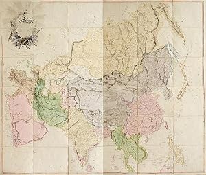
Asia. To Major James Rennell, Esqr. F.R.S. &c. &c. This Map is Inscribed, by His much Obliged Humble Servant. January 1st 1801. A. Arrowsmith.
Published by London, A. Arrowsmith No. 24 Rathbone Place, 1801., 1801
Seller: Antiquariat INLIBRIS Gilhofer Nfg. GmbH, Vienna, A, Austria
Association Member: ILAB PADA VDA VDAO
Seller rating 5 out of 5 stars
Signed
Engraved map, fine original hand-colour, edged with blue silk, housed in original marbled paper chemise and slipcase, with red morocco label, lettered in gilt. 1470 x 1290 mm. The most accurate map of Asia published at the beginning of the 19th century. It shows significant advancement compared with other maps of the period, incorporating the work of surveyors like James Rennell, to whom the map was dedicated. Rennell was surveyor-general of the East India Company's dominions in Bengal, and the information published in his "Bengal Atlas" in 1779 appears here. Arrowsmith also included remarkable topographical detail such as mountain ranges in regions as remote as Tibet. Remarkably the region on the shore of the Arabian Gulf is already labelled as "Bani Yas" territory. Arrowsmith has marked the track of Lap�rouse's voyage in the Indian Ocean and Far East. - Aaron Arrowsmith (1750-1823) was the finest cartographer of his generation. Although he received little formal education, it is believed that he was provided with some mathematical instruction by William Emerson, an author of several books on the application of mathematics to the area of cartography. Around 1770, Arrowsmith moved to London to seek employment. It is believed that he worked for William Faden before joining John Cary Sr. in the early 1780s. There he provided the measurements for John Cary's early publication detailing the roads from London to Falmouth, his first signed work. Arrowsmith set up on his own in 1790 and over the next thirty years produced some of the most beautiful and elegant maps of the era. - In perfect condition. - Not in Al Ankary or Al-Qasimi. Cf. Sweet 238 (1811 edition only).
-
Ancient India, as Described by Ptolemy, Being a Translation of the Chapters which Describe India and Central and Eastern Asia in the Treatise on Geography Written by Klaudios Ptolemaios, the Celebrated Astronomer, with Introductions, Commentary, Map.
Published by Trubner & Co.; Thacker, Spink & co.; B.E.S. Press, London; Calcutta; Bombay, 1885
Seller: William Chrisant & Sons, ABAA, ILAB. IOBA, ABA, Ephemera Society, Fort Lauderdale, FL, U.S.A.
Association Member: ABAA ESA ILAB
Seller rating 5 out of 5 stars
Signed
Condition: Very Good. Front board detached. Faded purple cloth with gilt title to spine. Endpapers slightly darkened by binder's glue bleed. "N. Y. City. Oct. 2. 1917" inscribed on flyleaf. Includes black and white fold-out map of India according to Ptolemy and extensive index. Includes 96 page catalogue of Trubner's Oriental & Linguistic Publications to rear. Wear to head and tail of spine. Clean interior with no previous owners' names or other defacements. Scarce. 6 x 9 in.
-

1850 Antique Map "ASIA MINOR" by Tallis CYPRUS TURKEY SYRIA RHODES (27dw)
Seller: Antique Paper Company, ASHFORD, KENT, United Kingdom
Seller rating 2 out of 5 stars
Signed
1850 Antique Map "ASIA MINOR" by Tallis CYPRUS TURKEY SYRIA RHODES (27dw) For more info please ask seller a question. Royal Mail 2nd Class - �0.00 Royal Mail 2nd Class Signed For - �4.50 Standard Int'l age - �4.00 Royal Mail International Signed - �8.00 No PICK UP OPTIONSorry, our items are NOT available for pick-up.PAYING VIA PAYPALWe accept on our all our items so you can shop with confidence.Simple choose the option when proceeding through the checkout.
-
Carte de la Californie et des Pays Nord-Ouest separ�s de l'Asie par le D�troit d'Anian (Map of California and Norwestern Territories Separated from Asia by the Strait of Anian)
Published by Vaugondy, Paris, 1772
Seller: Cole & Contreras / Sylvan Cole Gallery, Sitges, B, Spain
Seller rating 5 out of 5 stars
First Edition Signed
A fine and extremely unusual map in which we see two contrasting renderings of California (including Baja California), Northern Mexico (as far south as Culiac�n), and the entire northwestern part of North America (with a tiny bit of Siberia at upper right.) Includes the Sierra Nevada, San Miguel (San Diego), Mendocino and many other familiar place names, as well as many mythical and forgotten place names. Original color. Printed on fine, thick laid paper with huge margins. 35 x 46 cm. FINE AND BRIGHT, with no defects. One of the earliest examples of comparative cartography.
-
A collection of several relations & treatises singular and curious, of John Baptista Tavernier, Baron of Aubonne. Not printed among his first six voyages. Divided into five parts viz. I. A new and singular relation of the Kingdom of Tunquin, with several figures, and a map of the countrey. II. How the Hollanders manage their affairs in Asia. III. A relation of Japon, and the cause of the persecution of the Christians in those islands; with a map of the countrey. IV. A relation of what passed in the negotiation of the deputies which were at Persia and the Indies, as well on the French King's as the Company's behalf, for the establishment of trade. V. Observations upon the East India trade, and the frauds there subject to be committed. Publis
Published by Londres Printed by A. Godbid and J. Playford, for Moses Pitt at the Angel in S. Paul's Churchyard 1680, 1680
Seller: Librairie Vignes Online, Paris, France
Association Member: ILAB
Seller rating 5 out of 5 stars
First Edition Signed
Condition: Bon �tat. in-4, demi-veau jasp� � coins, dos � nerfs encadr�s de filets dor�s, pi�ce de titre maroquin rouge, plats de papier peign�, non rogn�, 1 f. + titre + 10 ff. (avertissement, d�dicace, pr�face, table)+14-[4]-15-46-[4]-47-87+66 pp. �dition originale anglaise (l'originale fran�aise parut chez Clouzier l'ann�e pr�c�dente) qui contient une description du Tonkin, d�riv�e des observations du fr�re de l'auteur, une description du Japon, recueillie aupr�s de n�gociants, et une violente attaque contre les agents de la Compagnie n�erlandaise des Indes orientales. La premi�re partie, consacr�e au royaume du Tunquin (Tonkin), est illustr�e de 8 planches grav�es d�pliantes oblongues. Mais il manque la planche r�unissant les cartes du Japon et du Tonkin. Initiales grav�es sur bois et ornements en t�te de chapitres. Notes manuscrites sur la premi�re page muette (deux citations po�tiques en anglais dont une d'Alexander Pope : "If to her share some female errors fall, Look on her face and you'll forget them all") et ex-libris manuscrit au bas de la page d'avertissement "Franceis Stephens book 1721". Cet ouvrage tr�s rare est conserv� dans une bonne reliure du d�but du XXe si�cle, mais pr�sente deux restaurations grossi�res (au premier feuillet de la pr�face et � la derni�re gravure coll�e qui ne se d�plie plus), quelques d�chirures sans manque (notamment sur trois des gravures), quelques rousseurs et t�ches.
-
Asia. To Major James Rennell, Esqr. F.R.S. &c. &c. This Map is Inscribed, by His much Obliged Humble Servant. January 1st 1801. A. Arrowsmith.
Published by London, G. Allen for A. Arrowsmith, 1801., 1801
Seller: Antiquariat INLIBRIS Gilhofer Nfg. GmbH, Vienna, A, Austria
Association Member: ILAB PADA VDA VDAO
Seller rating 5 out of 5 stars
Art / Print / Poster Signed
Engraved map in 36 segments on canvas, folded. Fine original hand-colour. Ca. 1450 x 1230 mm. Earliest edition of this wall map, the most accurate map of Asia published at the beginning of the 19th century. It shows significant advancement compared with other maps of the period, incorporating the work of surveyors like James Rennell, to whom the map was dedicated. Rennell was surveyor-general of the East India Company's dominions in Bengal, and the information published in his "Bengal Atlas" in 1779 appears here. Arrowsmith also included remarkable topographical detail such as mountain ranges in regions as remote as Tibet. Remarkably, the region on the shore of the Arabian Gulf is already labelled as "Bani Yas" territory. Arrowsmith has marked the track of Lap�rouse's voyage in the Indian Ocean and Far East. - Aaron Arrowsmith (1750-1823) was the finest cartographer of his generation. Although he received little formal education, it is believed that he was provided with some mathematical instruction by William Emerson, an author of several books on the application of mathematics to the area of cartography. Around 1770, Arrowsmith moved to London to seek employment. It is believed that he worked for William Faden before joining John Cary Sr. in the early 1780s. There he provided the measurements for John Cary's early publication detailing the roads from London to Falmouth, his first signed work. Arrowsmith set up on his own in 1790 and over the next thirty years produced some of the most beautiful and elegant maps of the era. "This highly detailed wall map of Asia is probably one of the most accurate maps of the continent before the completion of the Ordnance Survey maps of 1820" (Sweet). - Slightly soiled and browned, but well preserved. - Not in Al Ankary or Al-Qasimi. Cf. Sweet 238 (1811 edition only).
-
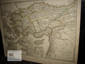
Asia Minor, Syria, Cyprus, Creta & Insulae maris Aegaei. Kleinasien, Mesopothanien, Syrien, Kreta und Zypern mit 3 Innenkarten von Helles Pontus und Troja, Ionia und dem Campus von Troja. Antique Map. Gro�e Landkarte von Poppey aus dem Historischen Atlas von Spruner 1850
Language: Latin
Published by Gotha: Justus Perthes um, 1850
Seller: historicArt Antiquariat & Kunsthandlung, Wiesbaden-Breckenheim, Germany
Seller rating 5 out of 5 stars
Map Signed
1. gro�e grenzkolorierte Landkarte mit 3 Innenkarten von Poppey (in der Platte signiert) auf r�ckseitig unbedrucktem B�ttenkarton mit dekorativ abgesetztem Plattenrand, sehr detailreiche und pr�zise Karte, Blattgr��e ca. 37,5 x 46 cm, von alter Hand sorgf�ltig grenzkoloriert, im breiten unteren Rand minimal angestaubt, ansonsten sehr gut erhalten gro�er und/oder schwerer Artikel mit zus�tzlichen Kosten f�r Versand und Versicherung - heavy and/or oversized item with additional costs for shipping and insurance - please ask us before you order this article 2100 gr.
-

1850 Illustrated Original Antique Map "RUSSIA IN ASIA" SIBERIA by TALLIS (176d)
Seller: Antique Paper Company, ASHFORD, KENT, United Kingdom
Seller rating 2 out of 5 stars
Signed
1850 Illustrated Original Antique Map "RUSSIA IN ASIA" SIBERIA by TALLIS (176d) For more info please ask seller a question. Royal Mail 2nd Class - �0.00 Royal Mail 2nd Class Signed For - �4.50 Standard Int'l age - �4.00 Royal Mail International Signed - �8.00 No PICK UP OPTIONSorry, our items are NOT available for pick-up.PAYING VIA PAYPALWe accept on our all our items so you can shop with confidence.Simple choose the option when proceeding through the checkout.
-

1850 Illustrated Original Antique Map "RUSSIA IN ASIA" SIBERIA by TALLIS (177d)
Seller: Antique Paper Company, ASHFORD, KENT, United Kingdom
Seller rating 2 out of 5 stars
Signed
1850 Illustrated Original Antique Map "RUSSIA IN ASIA" SIBERIA by TALLIS (177d) For more info please ask seller a question. Royal Mail 2nd Class - �0.00 Royal Mail 2nd Class Signed For - �4.50 Standard Int'l age - �4.00 Royal Mail International Signed - �8.00 No PICK UP OPTIONSorry, our items are NOT available for pick-up.PAYING VIA PAYPALWe accept on our all our items so you can shop with confidence.Simple choose the option when proceeding through the checkout.
-
[A Schematic Map of the Military Strategic Deployment of US Imperialism's Aggression in Asia.]
Publication Date: 1966
Seller: Geographicus Rare Antique Maps, Brooklyn, NY, U.S.A.
Association Member: ABAA ESA ILAB
Seller rating 4 out of 5 stars

Map Signed
Excellent. Size 7 x 7.5 Inches. A fascinating piece of Cold War propaganda, this map was published in 1966 in the PLA Pictorial , a periodical of China's People's Liberation Army. It presents U.S. military involvement in East Asia, including in Vietnam, as coordinated staging for an invasion of China. A Closer Look East Asia is presented with the People's Republic of China shaded in red. To the country's east and south, American ships and bases are indicated, including on Taiwan, which is shaded red like the mainland to reflect the P.R.C.'s territorial claims. More specifically, air, naval, and missile bases and the U.S. Navy's 7th Fleet are noted. These bases are divided into a first and second strategic line, bearing some resemblance to the 'First Island Chain' and 'Second Island Chain' discussed today in U.S. military and government documents. The first strategic line is divided into three sections, one emanating from Japan, a second from Taiwan and the Philippines, and a third from South Vietnam, Thailand, and the Bay of Bengal. China and the Vietnam War (Second Indochina War) When Chinese Communist forces occupied southern China, they provided a steady stream of weapons, supplies, and advisors to Viet Minh forces across the border in Tonkin. New units were formed, armed, and trained which were capable of launching full-scale offensives against French and French-aligned forces, resulting in the tide turning perceptibly towards the Viet Minh. Viet Minh troops also became increasingly effective at guerilla tactics, wearing down French supply lines and morale. The breaking point came with the Battle of Dien Bien Phu (March - May 1954), when the French overcommitted to a distant 'hedgehog' outpost that was difficult to relieve or resupply, leading eventually to the garrison's surrender. Afterward, the French government fell, and the 1954 Geneva Accords were signed, allowing for the independence of North Vietnam. This result would have been difficult to achieve, certainly within the same timeframe, without Chinese support. Even though China and North Vietnam had some issues between them (the Vietnamese were unhappy that the Geneva Accords were negotiated 'over their heads' by Zhou Enlai, for instance), the two countries remained close and North Vietnam modeled its political consolidation, land reform, and other policies on the Chinese experience a few years prior. With China under a U.S. maritime blockade and concerned about the potential for a U.S. invasion (their main motivation for intervening in the Korean War), continued support for North Vietnam and, by extension, the Viet Cong, was an easy choice as U.S. involvement in Vietnam increased during the 1960s. Domestic propaganda in China constantly played up the threat of U.S. invasion and glorified the Vietnamese people's resistance to 'U.S. imperialism'. However, by the time this map was published, Mao Zedong was already well on the way to determining that his greatest internal and external threat was 'Soviet Revisionism'. As the Sino-Soviet Split worsened, the relationship between China and North Vietnam likewise deteriorated, and several years later, the U.S. and China moved towards rapprochement. In recent years, as U.S.-China relations have again come under strain, Chinese concerns about U.S. military encirclement have resurfaced (though, within the PLA, they had never really disappeared). Publication History and Census This map was published in the April 19, 1966, issue of People's Liberation Army Pictorial , on the eve of the Cultural Revolution. It was an addendum to provide a clearer and more accurate version of a map that appeared in an article in the same issue, titled 'US imperialism is shifting its strategic focus to Asia and targeting China with its aggression ' (?????????????????????). The only institution noted as holding this map in the OCLC is Stanford University. References: OCLC 1082154110. Signed by Author(s).
-
Elizabeth Jane. [Manuscript polar projection map of the Northern Hemisphere.] Esholt Hall [Yorkshire:], October 21, 1807. [With:] Crompton, Henrietta Matilda. [Manuscript map of Asia.] Esholt Hall [Yorkshire:], May 1808. [With:[ Crompton, Mary F[rances]. [Manuscript polar projection map of the Southern Hemisphere.] Esholt Hall [Yorkshire:], 1807.
Seller: Michael R. Thompson Books, A.B.A.A., Los Angeles, CA, U.S.A.
Seller rating 1 out of 5 stars

Signed
The Crompton sisters� maps reflect the contemporary boom in Pacific exploration that filled in the blank spots on European maps and, similarly, include areas in the interior of Africa and the South Pacific that are marked as �unknown� to the British. A notable absence from the map of the Southern Hemisphere is most of Antarctica, since the first confirmed landing on the Antarctic mainland did not occur until January of 1820. In addition, these maps are fairly early representations of the political geography of South Africa after British ousted the Dutch colonial government and reoccupied the colony in 1806. The names of the locations recorded, like �New Holland� rather than Australia and �Prince William Land� rather than King William Island, reflect the geographical understanding of the early nineteenth century. Three maps (two have the dimensions 19� by 16� and the other is 16 � by 16 �). The maps, drawn in black ink, are very detailed, with delicate hatchwork and careful calligraphy. On paper watermarked �E&P 1801� for the papermaking firm Edmeades and Pine. Cream-colored paper illustrated on one side only. Small, circular holes in the centers of both polar projection maps (probably made by the artists to assist in making measurements). Some small tears to edges. One edge of the map of Asia has been reinforced on verso with document tape. Light intermittent dust soiling. A very good set of unique, richly detailed maps by three young women. These are unique items, most likely based on the maps of contemporary English cartographers. A possible source is James Wyld the Elder (1790 � 1836), who was known for his prompt publications of newly updated maps. Also note that, while the polar projection of the Southern Hemisphere is signed with the name of Mary Frances Crompton, the handwritten text on the map itself may be in Elizabeth�s hand. The two might have collaborated on the map or it may have been created by Elizabeth exclusively. The Crompton sisters� maps reflect the contemporary boom in Pacific exploration that filled in the blank spots on European maps and, similarly, include areas in the interior of Africa and the South Pacific that are marked as �unknown� to the British. A notable absence from the map of the Southern Hemisphere is most of Antarctica, since the first confirmed landing on the Antarctic mainland did not occur until January of 1820. In addition, these maps are fairly early representations of the political geography of South Africa after British ousted the Dutch colonial government and reoccupied the colony in 1806. The names of the locations recorded, like �New Holland� rather than Australia and �Prince William Land� rather than King William Island, reflect the geographical understanding of the early nineteenth century. We could not find more information about Elizabeth and Mary in the sources available to us, but Henrietta never married and spent much of her life traveling through Britain and Europe. She was a skilled painter and illustrator who continued to study art throughout her life and took lessons from notable painters like Copley Fielding and David Cox. Several of Henrietta�s sketchbooks, as well as her letters and papers, are held by the Yale Center for British Art.
-

1850 Illustrated Original Antique Map "RUSSIA IN ASIA" SIBERIA by TALLIS (181d)
Seller: Antique Paper Company, ASHFORD, KENT, United Kingdom
Seller rating 2 out of 5 stars
Signed
1850 Illustrated Original Antique Map "RUSSIA IN ASIA" SIBERIA by TALLIS (181d) For more info please ask seller a question. Royal Mail 2nd Class - �0.00 Royal Mail 2nd Class Signed For - �4.50 Standard Int'l age - �4.00 Royal Mail International Signed - �8.00 No PICK UP OPTIONSorry, our items are NOT available for pick-up.PAYING VIA PAYPALWe accept on our all our items so you can shop with confidence.Simple choose the option when proceeding through the checkout.
-

1850 Antique Map by Tallis of TIBET MANCHURIA CHINA ASIA KOREA (d143)
Seller: Antique Paper Company, ASHFORD, KENT, United Kingdom
Seller rating 2 out of 5 stars
Signed
1850 Antique Map by Tallis of TIBET MANCHURIA CHINA ASIA KOREA (d143) For more info please ask seller a question. Royal Mail 2nd Class - �0.00 Royal Mail 2nd Class Signed For - �4.50 Standard Int'l age - �4.00 Royal Mail International Signed - �8.00 No PICK UP OPTIONSorry, our items are NOT available for pick-up.PAYING VIA PAYPALWe accept on our all our items so you can shop with confidence.Simple choose the option when proceeding through the checkout.
-

1850 Antique Map by Tallis of TIBET MONGOLIA MANCHURIA CHINA ASIA KOREA (d144)
Seller: Antique Paper Company, ASHFORD, KENT, United Kingdom
Seller rating 2 out of 5 stars
Signed
US$ 101.98
US$ 7.92 shipping
Ships from United Kingdom to U.S.A.Quantity: 1 available
Add to basket1850 Antique Map by Tallis of TIBET MONGOLIA MANCHURIA CHINA ASIA KOREA (d144) For more info please ask seller a question. Royal Mail 2nd Class - �0.00 Royal Mail 2nd Class Signed For - �4.50 Standard Int'l age - �4.00 Royal Mail International Signed - �8.00 No PICK UP OPTIONSorry, our items are NOT available for pick-up.PAYING VIA PAYPALWe accept on our all our items so you can shop with confidence.Simple choose the option when proceeding through the checkout.
-

1850 RARE Antique Map "TURKEY IN ASIA" Syria Armenia TALLIS FULL COLOUR (75)
Seller: Antique Paper Company, ASHFORD, KENT, United Kingdom
Seller rating 2 out of 5 stars
Signed
US$ 115.58
US$ 7.92 shipping
Ships from United Kingdom to U.S.A.Quantity: 1 available
Add to basket1850 RARE Antique Map "TURKEY IN ASIA" Syria Armenia TALLIS FULL COLOUR (75) For more info please ask seller a question. Royal Mail 2nd Class - �0.00 Royal Mail 2nd Class Signed For - �4.50 Standard Int'l age - �4.00 Royal Mail International Signed - �8.00 No PICK UP OPTIONSorry, our items are NOT available for pick-up.PAYING VIA PAYPALWe accept on our all our items so you can shop with confidence.Simple choose the option when proceeding through the checkout.
-

1770 Original Antique Map "ASIA" by T KITCHIN Hand coloured - China Russia Japan
Seller: Antique Paper Company, ASHFORD, KENT, United Kingdom
Seller rating 2 out of 5 stars
Signed
US$ 169.97
US$ 7.92 shipping
Ships from United Kingdom to U.S.A.Quantity: 1 available
Add to basket1770 Original Antique Map "ASIA" by T KITCHIN Hand coloured - China Russia Japan For more info please ask seller a question. Royal Mail 2nd Class - �0.00 Royal Mail 2nd Class Signed For - �4.50 Standard Int'l age - �4.00 Royal Mail International Signed - �8.00 No PICK UP OPTIONSorry, our items are NOT available for pick-up.PAYING VIA PAYPALWe accept on our all our items so you can shop with confidence.Simple choose the option when proceeding through the checkout.
-

1850 Illustrated Antique Map of "CHINA AND BURMA" Asia by Tallis (71d)
Seller: Antique Paper Company, ASHFORD, KENT, United Kingdom
Seller rating 2 out of 5 stars
Signed
US$ 231.16
US$ 7.92 shipping
Ships from United Kingdom to U.S.A.Quantity: 1 available
Add to basket1850 Illustrated Antique Map of "CHINA AND BURMA" Asia by Tallis (71d) For more info please ask seller a question. Royal Mail 2nd Class - �0.00 Royal Mail 2nd Class Signed For - �4.50 Standard Int'l age - �4.00 Royal Mail International Signed - �8.00 No PICK UP OPTIONSorry, our items are NOT available for pick-up.PAYING VIA PAYPALWe accept on our all our items so you can shop with confidence.Simple choose the option when proceeding through the checkout.
-

1771 Antique Map ASIA Borneo Philippines Malaysia Japan Arabia Tartary Tibet BLM
Seller: Antique Paper Company, ASHFORD, KENT, United Kingdom
Seller rating 2 out of 5 stars
Signed
US$ 339.94
US$ 7.92 shipping
Ships from United Kingdom to U.S.A.Quantity: 1 available
Add to basket1771 Antique Map ASIA Borneo Philippines Malaysia Japan Arabia Tartary Tibet BLM For more info please ask seller a question. Royal Mail 2nd Class - �0.00 Royal Mail 2nd Class Signed For - �4.50 Standard Int'l age - �4.00 Royal Mail International Signed - �8.00 No PICK UP OPTIONSorry, our items are NOT available for pick-up.PAYING VIA PAYPALWe accept on our all our items so you can shop with confidence.Simple choose the option when proceeding through the checkout.
-

1850 RARE Antique Map of "ASIA" CHINA ARABIA RUSSIA Siam by TALLIS COLOUR (72)
Seller: Antique Paper Company, ASHFORD, KENT, United Kingdom
Seller rating 2 out of 5 stars
Map Signed
US$ 339.94
US$ 7.92 shipping
Ships from United Kingdom to U.S.A.Quantity: 1 available
Add to basketNo Binding. Condition: Fine. No Jacket. 1850 RARE Antique Map of "ASIA" CHINA ARABIA RUSSIA Siam by TALLIS COLOUR (72) For more info please ask seller a question. Royal Mail 2nd Class - �0.00 Royal Mail 2nd Class Signed For - �4.50 Standard Int'l age - �4.00 Royal Mail International Signed - �8.00 No PICK UP OPTIONSorry, our items are NOT available for pick-up.PAYING VIA PAYPALWe accept on our all our items so you can shop with confidence.Simple choose the option when proceeding through the checkout.
-

Antique Map of Asia 'in Frame, circa 1739'
Seller: Bartele Gallery - The Netherlands, Langweer, FRL, Netherlands
Seller rating 5 out of 5 stars
Signed
Antique map titled 'Asia Dividida em suas Regioens & Principaes Estados'. Rare and uncommon map of Asia. Signed '1739'. Source unknown, to be determined. Frame included. We carefully pack our framed items to ensure safe shipping.


![Seller image for [A Schematic Map of the Military Strategic Deployment of US Imperialism's Aggression in Asia.] for sale by Geographicus Rare Antique Maps](https://pictures.abebooks.com/inventory/md/md32068515311.jpg)
![Seller image for Elizabeth Jane. [Manuscript polar projection map of the Northern Hemisphere.] Esholt Hall [Yorkshire:], October 21, 1807. [With:] Crompton, Henrietta Matilda. [Manuscript map of Asia.] Esholt Hall [Yorkshire:], May 1808. [With:[ Crompton, Mary F[rances]. [Manuscript polar projection map of the Southern Hemisphere.] Esholt Hall [Yorkshire:], 1807. for sale by Michael R. Thompson Books, A.B.A.A.](https://pictures.abebooks.com/inventory/md/md30780795935.jpg)