Map Cape Cod by Walling Gray (1 results)
Seller: Art Source International Inc., Boulder, CO, U.S.A.Art Source International Inc.
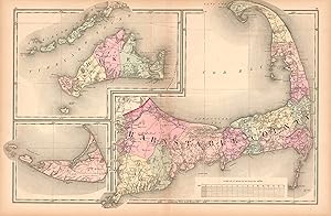
Contact seller5-star sellerThis hand colored map is from Walling and Grays Official Topographical Atlas of Massachusetts from Astronomical, Trigonometrical, and Various Local Surveys published in 1871. This bright pastel map of Cape Cod identifies counties and important cities, water bodies, rivers, major roads and hills. Insets at the same scale illusrat…e Nantucket, the Elizabeth Islands and Dukes Island with the vineyard region identified. This map measures 23.5 inches by 16.5 inches.
