Order Total (1 Item Items):
Shipping Destination:

Map Dakota, Used (273 results)
Skip to main search results
Search filters
Product Type
- All Product Types
- Books (185)
- Magazines & Periodicals (1)
- Comics (No further results match this refinement)
- Sheet Music (No further results match this refinement)
- Art, Prints & Posters (18)
- Photographs (1)
- Maps (68)
- Manuscripts & Paper Collectibles (No further results match this refinement)
Condition Learn more
- New (No further results match this refinement)
- As New, Fine or Near Fine (31)
- Very Good or Good (122)
- Fair or Poor (5)
- As Described (115)
Binding
Collectible Attributes
Language (2)
Free Shipping
Seller Location
Seller Rating
-

map. Condition: Very Good. Connecting readers with great books since 1972! Used books may not include companion materials, and may have some shelf wear or limited writing. We ship orders daily and Customer Service is our top priority!
-

Dakota/Lakota Star Map Constellation Guidebook: An Introduction to D(L)akota Star Knowledge
Seller: Books From California, Simi Valley, CA, U.S.A.
Seller rating 4 out of 5 stars

Paperback. Condition: Very Good.
-
NORTH DAKOTA SOUTH DAKOTA Highway Map - Standard Oil - 1969
Published by Standard Oil, 1969
Map First Edition
Soft cover. Condition: Very Good. No Jacket. 1st Edition. Folded map size about 4 by 9 inches. Opens to about 18 by 32 inches. Printed on both sides in color. Light wear. VERY GOOD.
-
NORTH DAKOTA SOUTH DAKOTA Highway Map - Standard Oil - 1967
Published by Standard Oil, 1967
Map First Edition
Soft cover. Condition: Very Good. No Jacket. 1st Edition. Folded map size about 4 by 9 inches. Opens to about 18 by 28 inches. Printed in color on both sides. Light edge wear. VERY GOOD.
-

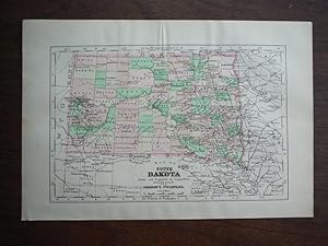
MAP OF SOUTH DAKOTA (from New Standard Atlas of the World)
Language: English
Published by Rand McNally, 1890
Pamphlet. Condition: Very Good. Map is 14 x 10.5 inches, pastel colors, VG.
-
A MAP SEQUENCE OF THE BELLE FOURCHE IRRIGATION PROJECT [SOUTH DAKOTA]
Published by J Geography, 1935
Magazine / Periodical First Edition
Pamphlet. Condition: Very Good. 1st Edition. Vol 34, No 3, pp. 109-119, Maps, Extracted from orig vol, thus begins with title page, trimmed & stapled pamphlet, else VG.
-

Condition: As New. Unread book in perfect condition.
-

Condition: As New. Unread book in perfect condition.
-
Condition: Like New. In unused condition, may show some slight shelf wear, but otherwise unread. This title was digitally scanned from a rare, out of print edition, and will have some visual artifacts from that process.
-
Condition: Like New. In unused condition, may show some slight shelf wear, but otherwise unread. This title was digitally scanned from a rare, out of print edition, and will have some visual artifacts from that process.
-
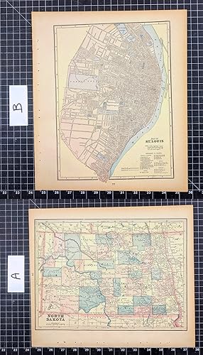
Johnson's Map of South Dakota - Original (1895)
Language: English
Published by A. J. Johnson Company, 1895
Seller: Imperial Books and Collectibles, Wauwatosa, WI, U.S.A.
Seller rating 5 out of 5 stars

No Binding. Condition: Fine. This rare original hand colored copper plate engraved map of South Dakota is from Volume VII of the 1895 edition of the acclaimed Johnson's Universal Cyclopaedia. Counties are distinguished by color. Cities, towns, roads and rail lines are clearly depicted. Plate size: 9x6". Margin: 1/2" min.
-
Co-op Road Map of North Dakota South Dakota
Published by Farmers Union Central Exchange, Inc.; South Saint Paul, MN
Soft cover. Condition: Good. Road map. South Dakota on one side, North Dakota on the reverse. General wear - a couple seams are beginning to split and there are short splits on the edges. Three of the interior fold points are worn thru. No date of publication, but city/town populations are from the 1950 Census.
-
US$ 10.02 30% off
US$ 7.02
US$ 5.85 shipping
Ships within U.S.A.Quantity: 1 available
Add to basketNo Binding. Condition: VG. Sized about 8 x 12 inches, clean and bright. Unrelated map on verso.
-
US$ 10.02 30% off
US$ 7.02
US$ 5.85 shipping
Ships within U.S.A.Quantity: 1 available
Add to basketNo Binding. Condition: VG. Sized about 8 x 12 inches, clean and bright. Unrelated map on verso.
-
US$ 10.02 30% off
US$ 7.02
US$ 5.85 shipping
Ships within U.S.A.Quantity: 1 available
Add to basketNo Binding. Condition: VG. Sized 10 x 14 inches, very clean and bright. Unrelated map on verso.
-
Popular Map of North Dakota, in Color
Language: English
Published by Rand McNally & Company, Chicago
US$ 10.02 30% offUS$ 7.02
US$ 5.85 shipping
Ships within U.S.A.Quantity: 1 available
Add to basketNo Binding. Condition: VG. Circa 1937, sized about 11 x 14 inches, North Carolina map on verso.
-
map. Condition: Good. Book shows common (average) signs of wear and use. Binding is still tight. Covers are intact but may be repaired. We have 75,000 books to choose from -- Ship within 24 hours -- Satisfaction Guaranteed!
-

MAP: 'North Dakota'.from Rand McNally's Dollar Atlas of the World
Published by Rand McNally & Co, Chicago IL, 1916
Seller: Dorley House Books, Inc., Hagerstown, MD, U.S.A.
Seller rating 4 out of 5 stars
Art / Print / Poster
Unbound. Condition: Very Good. Colored Map (illustrator). 5.5" x 7'' map; suitable for framing Size: 5.5" x 7''.
-

MAP: 'South Dakota'.from Rand McNally's Dollar Atlas of the World
Published by Rand McNally & Co, Chicago IL, 1916
Seller: Dorley House Books, Inc., Hagerstown, MD, U.S.A.
Seller rating 4 out of 5 stars
Art / Print / Poster
Unbound. Condition: Very Good. Colored Map (illustrator). 5.5" x 7'' map, suitable for framing Size: 5.5" x 7''.
-
Map, Paper. Condition: Fine. Undated Edition. Folding Road Map for North Dakota. Issued free compliments of Standard Oil to GasStation customers. Undated - but last Census figures shown are for 1950. Unfolds to 24" by 18", printed on both sides. Bright, clean and unmarked. Almost 'as new'. Weight, 22g. Size: 4" by 9" Folded. Book.
-

Condition: As New. Unread book in perfect condition.
-

The Corn Palace Story with a Description of Early South Dakota and Mitchell, and a Map Indicating South Dakota Indian Reservations
Published by Robert Schutt, Mitchell, South Dakota, 1976
Soft cover. Condition: Very Good. Crisp pamphlet with only the slightest bit of shelfwear. Clean pages. 16pp.
-
Pamphlet. Condition: Very Good. Lge White & Blk Map, Red Numbers Denotes Railroad lines (of which there are 8), (Index of Towns & Villages with Population on Back Side), 13 x 20 inches, Extracted from orig Atlas, else VG (Map also shows township & range lines).
-
Pamphlet. Condition: Very Good. Lge White & Blk Map, Red Numbers Denotes Railroad lines (of which there are 11), (Index of Towns & Villages with Population on Back Side), 13 x 20 inches, Extracted from orig Atlas, else VG (Map also shows township & range lines).
-
Pamphlet. Condition: Very Good. Map is 14 x 10.5 inches, pastel colors, VG.
-

Hydrologic Unit Map State of North Dakota 1974
Published by Department of the Interior - Canada, Washington DC, 1976
Paperback. Condition: Good. minor wear to large, folded map in 9.5 x 12 manila envelope, map shows political boundaries and water resources in North Dakota in black, red, blue and green Size: 9.5 x 12.
-
Dakota/Lakota Star Map Constellation Guidebook: An Introduction to D(L)akota Star Knowledge
Published by Native Skywatchers
paperback. Condition: LikeNew. Used Like New, no missing pages, no damage to binding, may have a remainder mark.
-
North Dakota Grand Forks Sheet Soil Map 1902
Language: English
Published by USDA, place not stated, 1902
First Edition
No Binding. Condition: Very Good. 1st Edition. A 15 by 38.5 inch single sheet map in 6 colors, folded to 6 by 9 inches, as issued. Edition of 1902. Lightly age-darkened paper, else VG. USDA Department of Soils. Shelf 13, map 32.
-
National Geographic Magazine - April, 2004. With Map Supplemnt, Bird Migration. Tornados, Cranes, Johannesburg, South Dakota Badlands, Tigers in the Hukawng Valley of Death (Myanmar), Wiscasset, Maine - Worm Capital of the World
Language: English
Published by National Geographic Society, Washington, DC, 2004
Seller: Singularity Rare & Fine, Baldwinsville, NY, U.S.A.
Seller rating 5 out of 5 stars
First Edition
Soft cover. Condition: Very Good. 1st Edition. Very Good. See scans and description. Washington, DC: National Geographic Society, 2004. The April, 2004 issue of National Geographic magazine, with the included separate map supplement, "Bird Migration". (scan). Quarto, photo-illustrated perfect-bound wraps, 136 pp. Very Good; has been perused, and covers show moderate signs of that, with a notable rear-cover crease. See scans. Contents and map supplement are Fine. Cover article serves up something we all wish we could be doing, "Chasing Tornadoes". Other feature topics include (the migratory) Cranes, Johannesburg, the South Dakota Badlands, Tigers in the Hukawng Valley of Death (Myanmar), and Wiscasset, Maine - "Worm Capital of the World". Yay. Departments include OnScreen and Online, From the Editor, Forum, Geographica, My Seven, Do It Yourself, Behind the Scenes, Who Knew?, Final Edit, On Assignment, and Flashback. Please see scans. This item is on premises, of course. LPR13.
-
Map. Condition: Very Good. Original color lithograph leaf from Cram's Atlas of the World. Please refer to photo for condition. PLEASE NOTE: If two images are shown they represent the obverse and reverse of the same leaf--not two separate leaves. Overall dimensions approx. 11.25" x 13.75. This item will be shipped flat.