Order Total (1 Item Items):
Shipping Destination:

Map Dunkirk Harbor (3 results)
Skip to main search results
Search filters
Product Type
- All Product Types
- Books (3)
- Magazines & Periodicals (No further results match this refinement)
- Comics (No further results match this refinement)
- Sheet Music (No further results match this refinement)
- Art, Prints & Posters (No further results match this refinement)
- Photographs (No further results match this refinement)
- Maps (No further results match this refinement)
- Manuscripts & Paper Collectibles (No further results match this refinement)
Condition Learn more
- New (1)
- As New, Fine or Near Fine (No further results match this refinement)
- Very Good or Good (No further results match this refinement)
- Fair or Poor (No further results match this refinement)
- As Described (2)
Binding
- All Bindings
- Hardcover (1)
- Softcover (No further results match this refinement)
Collectible Attributes
- First Edition (No further results match this refinement)
- Signed (No further results match this refinement)
- Dust Jacket (No further results match this refinement)
- Seller-Supplied Images (3)
- Not Print on Demand (2)
Language (1)
Price
- Any Price
- Under US$ 25 (No further results match this refinement)
- US$ 25 to US$ 50
- Over US$ 50
Free Shipping
Seller Location
Seller Rating
-
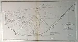
Map of Dunkirk Harbor N.Y. Showing the Works Erected by the United States
Publication Date: 1855
Seller: Art Source International Inc., Boulder, CO, U.S.A.
Seller rating 5 out of 5 stars
 US$ 35.00 10% off
US$ 31.50
US$ 16.00 shipping
Ships within U.S.A.Quantity: 3 available
Add to basketThis black and white, antique coastal survey was made for the United States Coast Survey. The surveys provide notes on important characteristics of the area mapped including depth readings. These charts illustrate areas that have likely undergone significant changes due to modifications and recessions of coastal lands, making them fascinating to anyone interested in local geography and history. This coastal survey, produced in 1855, shows the work erected in Dunkirk Harbor by the United States and the plan of those projected for its further improvement. This map measures 16.5 inches by 8.75 inches.
-

LeatherBound. Condition: New. BOOKS ARE EXEMPT FROM IMPORT DUTIES AND TARIFFS; NO EXTRA CHARGES APPLY. LeatherBound edition. Condition: New. Reprinted from 1819 edition. Leather Binding on Spine and Corners with Golden leaf printing on spine. NO changes have been made to the original text. This is NOT a retyped or an ocr'd reprint. Illustrations, Index, if any, are included in black and white. Each page is checked manually before printing. Pages: 326 As this print on demand book is reprinted from a very old book, there could be some missing or flawed pages, but we always try to make the book as complete as possible. Fold-outs, if any, are not part of the book. If the original book was published in multiple volumes then this reprint is of only one volume, not the whole set. Sewing binding for longer life, where the book block is actually sewn (smythe sewn/section sewn) with thread before binding which results in a more durable type of binding. Pages: 326 Language: English.
-
Map of Dunkirk Harbor
Publication Date: 1838
Seller: Art Source International Inc., Boulder, CO, U.S.A.
Seller rating 5 out of 5 stars
US$ 75.00 10% offUS$ 67.50
US$ 16.00 shipping
Ships within U.S.A.Quantity: 1 available
Add to basketThis 1838 black and white "Map of Dunkirk Harbor showing the works erected by the United States and the plan of those projected for its further improvement; together with the changes of outline of shore caused by their erection up to Sep. 30th, 1838", in New York, on Lake Erie, accompanied the Annual Report 1838, W.G. Williams, Capt., U.S. Topgl Eng's. This map measures 24 inches by 12.5 inches.