
Map Eastern Europe: First Edition (8 results)

- Softcover
- First Edition
Seller: Academic Books, Rockville, MD, U.S.A.Academic Books
Contact seller3-star sellerCondition: Used - Good
US$ 10.45
US$ 5.00 shippingShips within U.S.A.Quantity: 1 available
Soft cover. Condition: Good. 1st Edition. Book is used. Some highlighting and marginalia.
- Softcover
- First Edition
Seller: Prometei Books, New Rochelle, NY, U.S.A.Prometei Books
Contact seller5-star sellerCondition: Used - Very good
US$ 19.49
US$ 5.00 shippingShips within U.S.A.Quantity: 1 available
Soft cover. Condition: Very Good. 1st Edition. Paperback cover corners show creases from shelfwear. Otherwise new book, never read. Pages clean and crisp, spine unbroken. 0819A.
 More images
Language: French
Published by Chez Elwe & Langeveld / Renier & Ioshua Ottens, Amsterdam
- First Edition
Seller: Khalkedon Rare Books ABA, ILAB, IOBA, ESA, Istanbul, TurkeyKhalkedon Rare Books ABA, ILAB, IOBA, ESA
Contact seller5-star sellerCondition: Used - Very good
US$ 950.00
US$ 20.66 shippingShips from Turkey to U.S.A.Quantity: 1 available
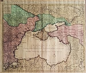
No Binding. Condition: Very Good. 1st Edition. An 18th-century hand-colored copper engraved map of Ukraine and the Black Sea in a fine impression with original hand-coloring in its period. 52x62 cm. In French. Scale: 1/2750000. Slight stains on the upper margin. Faded on paper. Otherwise a very good map. Rare in original color s…howing the Black Sea and its surroundings, of the little Tartary and the Black Sea of Delisle republished by Renier and Joshua Ottens. Can be seen on the map, Moldavia, Bulgaria, Natolia, Little Tartarie, Ukraine, and Crimea with contiguous regions and hinterland. In the century when this map was prepared (18th century), firstly, the territory of Crimea was controlled by the Crimean Khanate, then it was annexed by the Russian Empire on 19 April [O.S. 8 April] 1783. The period before the annexation was marked by Russian interference in Crimean affairs, a series of revolts by Crimean Tatars, and Ottoman ambivalence. The annexation began 134 years of rule by the Russian Empire, which ended with the Russian Revolution of 1917. Guillaume Delisle was a French cartographer known for his popular and accurate maps of Europe and the newly explored Americas. At 27, Delisle was admitted into the French Académie Royale des Sciences, an institution financed by the French state. After that date, he signed his maps with the title of "Géographe de l'Académie". Five years later, he moved to the Quai de l'Horloge in Paris, a true publishing hub where his business prospered. Delisle's progress culminated in 1718 when he received the title of Premier Géographe du Roi. He was appointed to teach geography to the Dauphin, King Louis XIV's son, a task for which he received a salary. Again, his father's reputation as a man of science probably helped the younger Delisle. In Delisle's case, it could be said that his accomplishments surpassed his father's. Up to that point, he had drawn maps not only of European countries, such as Italy, Spain, Germany, Great Britain, and Poland, and regions such as the Duchy of Burgundy, but he had also contributed to the empire's claims to recently explored continents of Africa and the Americas. Publisher: Jan Barend Elwe (177-1815), was a Dutch publisher and bookseller who reissued maps by De l'Isle and Ottens and some other cartographers in the late 18th century. His famous map "Amerique Septentrionale Divisee en ses Principales Parties" was derived mainly from Sanson's and Jaillot's maps of 1656 and 1676. This map was published in 1792 in an Atlas which included 37 other maps of different countries and regions.

Published by Amsterdam 1792
- First Edition
- Art Print
Seller: Trillium Antique Prints & Rare Books, Franklin, TN, U.S.A.Trillium Antique Prints & Rare Books
Contact seller3-star sellerCondition: Used - Fine
US$ 375.00
US$ 10.00 shippingShips within U.S.A.Quantity: 1 available
Condition: Fine. 1st Edition. This first edition, originally hand-colored map is from Jan Berend Elwe's "Atlas". The work was published in Amsterdam for the author circa 1792. --- The frontispiece from the work was engraved by I. van Munnikhuyse after L. Webbers. Most of the maps available from the atlas are dated 1792. Many of…the maps appear to be directly influenced by R. & I. Ottens atlas. (Koeman p. 105) --- The work is in very good to excellent condition overall. There is a light water stain in the upper right corner. There may be a few minor imperfections or fox marks to be expected with age. Please review the image carefully for condition and contact us with any questions. --- Paper Size ~ 25" by 21 1/4" (Fold Out).

Published by Clarendon Press Oxford -2017 1990
- First Edition
Seller: Francis Edwards ABA ILAB, Hay on Wye, , United KingdomFrancis Edwards ABA ILAB
Contact seller5-star sellerCondition: Used
US$ 1,499.11
US$ 25.14 shippingShips from United Kingdom to U.S.A.Quantity: 1 available
1st English Ed. [Vol. IV. Map Folder German Ed.]. 9 vols. in 12. Numerous diagrams, figures, maps; with 27 folding maps in seperate folder. E.p. maps, good in d/ws. with very minor signs of wear, some fading to lettering on several spines; map folder bound in black plastic ring binder spine with white lettered black laminated li…mp card wrapps. 'Germany and the Second World War (Das Deutsche Reich und der Zweite Weltkrieg) is a comprehensive, multi-volume academic history of World War II produced by the Militärgeschichtliches Forschungsamt (MGFA Military History Research Office) of the German Armed Forces. It is widely regarded as the definitive, scholarly account of the war from the German perspective.' Additional postage may be necessary US$1485.
 More images
Published by Mortier, Amsterdam 1700
- First Edition
- Map
Seller: Hammelburger Antiquariat, Hammelburg, , GermanyHammelburger Antiquariat
Contact seller5-star sellerCondition: Used - Fair
US$ 3,191.20
US$ 34.43 shippingShips from Germany to U.S.A.Quantity: 1 available
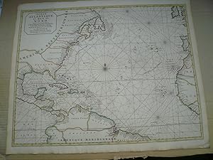
Kein Einband. Condition: Ausreichend. 1. Auflage. Ocean Atlantique ou Mer du Nord. Ou sont Exactement observee le Route d'Europe aux Indes Occidentales in Europe . . . . 17th Century Dutch Sea Chart of The East Coast of America and the Atlantic Trade Route, illustrating the modern European Trade Routes to the West Indies and Eas…tern Coast of America at the end of the 17th Century . Edited anno 1700, Mortier Pierre, coloured by an contemporary hand. Size of the sheet: 51 x 62 cm., good condition, only little brownish. Fine original color example of Pierre Mortier's large format map of the Eastern Coastline of North America, Gulf Coast, Caribbean, Central America and the northern coasts of South America, illustrating the trans-Atlantic trade route from Europe to the "Indes Occidentales" and return route via the Eastern Seaboard, following what would later become known as the Gulf Stream.
 More images
Published by Published: Dated and copyrighted to J. H. Colton, 1855. Published from Colton's 172 William Street Office in New York City. 1855
- First Edition
- Map
Seller: Schilb Antiquarian, Columbia, MO, U.S.A.Schilb Antiquarian
Contact seller5-star sellerCondition: Used - Near fine
US$ 99.00
Free ShippingShips within U.S.A.Quantity: 1 available
No Binding. Condition: Near Fine. 1st Edition. 1855 1st COLTON Atlas Color Map of Eastern Hemisphere Asia Africa Europe 14x17in A beautiful 1855 first edition Colton map Cartographer: J. H. Colton Title: Eastern Hemisphere Published: Dated and copyrighted to J. H. Colton, 1855. Published from Colton's 172 William Street Office i…n New York City. Language: English FREE SHIPPING WORLDWIDE Wear: wear as seen in photos Publisher: Dated and copyrighted to J. H. Colton, 1855. Published from Colton's 172 William Street Office in New York City. Size: ~14in x 17in (35cm x 43cm) FREE SHIPPING WORLDWIDE Shipping: Very Fast. Very Safe. Free Shipping Worldwide. Satisfaction Guarantee: Customer satisfaction is our first priority. Notify us within 7 days of receiving your item and we will offer a full refund guarantee without reservation.
 More images
- First Edition
Seller: Henry Sotheran Ltd, London, United KingdomHenry Sotheran Ltd
Contact seller5-star sellerCondition: Used
US$ 10,221.19
US$ 52.93 shippingShips from United Kingdom to U.S.A.Quantity: 1 available
London, W. Innys and R. Manby, 1738. 4to. Contemporary full sprinkled calf, spine with raised bands and red morocco lettering-piece; pp. [4], ix, [3], 463, large (640 x 960 mm) engraved folding map, hand-coloured in outline and paper-backed at the time, fold-out map, 9 engraved plates (2 folding), large folding woodcut map, very… large folding comparative linguistic table, head and tail of spine a little worn, as well as rubbing to extremities, small marginal trace of worming to inside of lower cover, rear fly-leaf and the final three printed leaves, title with very faint spotting, otherwise a remarkable, clean, and fresh copy; name of George Bouwman (18th-century) on verso of the large map, contemporary name in ink of James S. George at head of the first page of the main text.First English edition, reissue of the 1736 issue with new title-page. The Swedish officer Strahlenberg had been taken captive during Charles XII's Russian campaign and was detained for 13 years in Siberia. Situated from 1711 to 1721 in Tobolsk he was able to explore vast stretches of land eastward. The map, which had been published separately in 1730 in Stockholm, as well as the text remained one of the most accurate and best for decades to come. This book is one of the most important sources of historical-geographical and ethnographic information about Siberia and beyond. - The map is rarely found coloured.Cordier 2713; Cox I, 194; ESTC T100339.


