Map Europe: Signed (12 results)

- Hardcover
- Signed
Seller: Wonder Book, Frederick, MD, U.S.A.Wonder Book
Contact seller5-star sellerCondition: Used - Very good
US$ 17.06
Free ShippingShips within U.S.A.Quantity: 1 available
Condition: Very Good. Signed Copy . Very Good dust jacket. Signed by author on front endpage.
 More images
- Hardcover
- First Edition
- Signed
Seller: BADGERS BOOKS ONLINE, Littlehampton, , United KingdomBADGERS BOOKS ONLINE
Contact seller5-star sellerCondition: Used - Fine
US$ 27.63
US$ 43.60 shippingShips from United Kingdom to U.S.A.Quantity: 1 available
Hardcover. Condition: Fine. Dust Jacket Condition: Fine. First Edition. FINE hardback in FINE dustwrapper. 2013 Picador, First Edition. SIGNED by the author on title page. NO inscriptions, NOT price clipped. NB: REGRETTABLY NOT AVAILABLE TO SEND TO EU COUNTRIES. Signed by Author(s).

- Signed
- Art Print
Seller: Antique Paper Company, ASHFORD, KENT, United KingdomAntique Paper Company
Contact seller2-star sellerCondition: Used
US$ 19.34
US$ 8.05 shippingShips from United Kingdom to U.S.A.Quantity: 1 available
1885 TURKEY IN EUROPE Eastern Roumelia Roumania Serbia Austria ANTIQUE MAP (133) For more info please ask seller a question. Royal Mail 2nd Class - £0.00 Royal Mail 2nd Class Signed For - £4.50 Standard Int'l age - £4.00 Royal Mail International Signed - £8.00 No PICK UP OPTIONSorry, our items are NOT available for pick-up.PAYIN…G VIA PAYPALWe accept on our all our items so you can shop with confidence.Simple choose the option when proceeding through the checkout.

Language: English
Published by Odyssey Publications; Airphoto International Ltd., Hong Kong * * * * * 2007
- Softcover
- Signed
- Map
Seller: L. Michael, North Hollywood, CA, U.S.A.L. Michael
Contact seller4-star sellerCondition: Used - Fine
US$ 315.20
US$ 15.26 shippingShips within U.S.A.Quantity: 1 available
Soft cover. Condition: Fine. Map: Fine/, $589.80, Reduced From. 9789622177888 the ANCIENT SILK ROAD MAP: an Illustrated Map Featuring the Ancient Network of Routes Between CHINA and EUROPE; One large overview map and three detailed regional maps. Comprehensive notes with cultural and Historical information on key places and peop…le, 35 superb colour photographs, easy~to~use fold~out format. ONLINE Synopsis: Made famous in the West by the Venetian adventurer, Marco Polo, the ancient Silk Road spanned one-quarter of the circumference of the Earth. An intricate network of trading routes, in its heyday it stretched from Lyoyang and Xi'an in China, through Central Asia to Istanbul and Rome, perhaps the first example of the globalisation of trade. Untold perils, both natural and man-made, awaited the hardy merchants and travellers who ventured along the Silk Road's many branches in search of profit, learning or simply adventure. Conquering armies, too, swept back and forth throughout the centuries of the Road's existence. All have left their mark in some way. Inside are four detailed maps of the Silk Road's arteries supplemented by 35 colour photographs and historical notes on key places and notable people.* TUCKER, Jonathan; TOZER, Antonia Odyssey Publications; Airphoto International Ltd. 2007 Hong Kong * * * * * UnStated Edition Tall Wide Folding Map S/c Soft Cover Map: Fine/, Slight, Shelf, Edge And Corner Wear. Pages Printed On 0ff~White Paper, Clean And Tight To The Spine, In Fine/ Condition. Appear To Be Viewed. D/j: None. This Item Will Be Sent Wrapped In Plastic, Taped Shut And In A = Padded Mailing Envelope To Prevent Shipping Damage So That It Will Arrive In The Description Described Which Applies To This B00K, Only. = No Odors, No Writing, No Names, No Rippling, Not Stuck Together, No Book Plate, Not X~Library, No Other Marks. = Will Make It, An Excellent Addition To Your Own Personal Library Collection, Or As A Gift, For The Discriminating Reader / Collector. = WORLD WIDE SHIPPING, AVAILABLE *. Map: Fine/, 2007 (illustrator). Signed by Author(s).

- Softcover
- Signed
- Print on Demand
Seller: Forgotten Books, London, United KingdomForgotten Books
Contact seller4-star sellerCondition: New
US$ 30.50
Free ShippingShips from United Kingdom to U.S.A.Quantity: Over 20 available
Paperback. Condition: New. Print on Demand. This book is a collection of peace treaties, agreements, protocols, and declarations signed between various European powers and other nations from 1814 to 1878. The book provides a valuable historical record of the diplomatic efforts undertaken to resolve conflicts and establish peace…during this period. The author includes treaties that ended major conflicts such as the Napoleonic Wars, the Crimean War, and the Russo-Turkish War, as well as agreements that defined national boundaries, established international organizations, and regulated specific issues such as navigation rights and the treatment of prisoners of war. The book's comprehensive collection of primary source documents offers researchers and historians a wealth of material for studying the diplomatic history of the 19th century and the evolution of international relations during this transformative period. This book is a reproduction of an important historical work, digitally reconstructed using state-of-the-art technology to preserve the original format. In rare cases, an imperfection in the original, such as a blemish or missing page, may be replicated in the book. print-on-demand item.
 More images
- Softcover
- Signed
- Print on Demand
Seller: Forgotten Books, London, United KingdomForgotten Books
Contact seller4-star sellerCondition: New
US$ 30.65
Free ShippingShips from United Kingdom to U.S.A.Quantity: Over 20 available
Paperback. Condition: New. Print on Demand. This book contains a collection of international diplomatic agreements, treaties, declarations, and other instruments that were signed and ratified between 1814 and 1827. The collection provides original source material on the major treaties and agreements between nations that shaped t…he political and territorial boundaries of Europe following the defeat of Napoleon. Through these documents, the author presents a chronological overview of the diplomatic efforts aimed at stabilizing and legitimizing the post-revolutionary and Napoleonic order in Europe. By drawing on primary sources, this book serves as a valuable resource for diplomatic historians, providing insights into the complex web of international relations and peace negotiations of the early 19th century. This book is a reproduction of an important historical work, digitally reconstructed using state-of-the-art technology to preserve the original format. In rare cases, an imperfection in the original, such as a blemish or missing page, may be replicated in the book. print-on-demand item.
 More images
Published by Franklin D. Richards; London: Latter-Day Saints Book Depot, Liverpool 1855
- Hardcover
- Signed
Seller: Donald A. Heald Rare Books (ABAA), New York, NY, U.S.A.Donald A. Heald Rare Books (ABAA)
Contact seller5-star sellerCondition: Used
US$ 14,500.00
US$ 25.00 shippingShips within U.S.A.Quantity: 1 available
4to. (12 x 9 1/2 inches). viii, 120 pp. Folding map, thirty engraved plates, and woodcuts in text illustrations after Frederick H. Piercy. Contemporary half calf and tan cloth covered boards, rebacked. Housed in a red morocco backed box. A landmark depiction of the West with superb plates, and one of the most important publicati…ons devoted to the Mormon emigration: with provenance to Brigham Young's daughter. "This elaborately prepared and illustrated book was published as a monument to the Mormon emigration to Utah, and as a means of attracting further emigrants. Piercy made a special trip to America [in 1853] to make sketches for the plates, which are some of the best western views of the period" (Streeter). The outstanding views show New Orleans, Natchez, Vicksburg, Nauvoo, Council Bluffs, Laramie, Fort Bridger, and Scott's Bluff. ".One of the most elaborately and beautifully illustrated of western books" (Howes). ".One of the basic sources of illustrated Western Americana of the period" (Taft). "One of the most illuminating maps of the West to appear during 1855.it shows Utah in all its glory. This is not only an important map in the history of Mormons, but is in every sense an important map in the history of the West, giving as it does a carefully drawn picture of that entire area" (Wheat). This copy inscribed by Brigham Young's daughter Maria Young Dougall (1849-1935) to her niece Leah Dunford Widstoe and her husband, John A. Widstoe (1872-1952), a member of the Quorum of the Twelve Apostles. It is additionally signed by prominent LDS Elder (and Maria Dougall's husband) William Bernard Dougall (1843-1909). Howes L359, "b;" Wagner-Camp 259; Graff 2501; Flake 6381; Sabin 41325; Streeter Sale 2296; Taft, Artists & Illustrators of the Old West, p.285; Wheat Transmississippi IV, pp.40-41; Crawley & Flake, A Mormon Fifty 46.
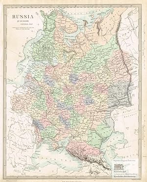
Published by London: Edward Stanford um 1870
- First Edition
- Signed
- Map
Seller: historicArt Antiquariat & Kunsthandlung, Wiesbaden-Breckenheim, , GermanyhistoricArt Antiquariat & Kunsthandlung
Contact seller5-star sellerCondition: Used
US$ 89.42
US$ 13.89 shippingShips from Germany to U.S.A.Quantity: 1 available
1. Original-Stahlstich von J. & C. Walker (in der Platte signiert) auf rückseitig unbedrucktem Büttenblatt, von alter Hand prächtig flächenkoloriert, mit Einzeichnung der bis dahin in Betrieb befindlichen russischen Eisenbahnen, bildliche Darstellung ca. 39,5 x 30,5 cm, Blattgröße ca. 43 x 36 cm, im breiten Rand außerhalb der bi…ldlichen Darstellung etwas angestaubt, ansonsten sauber und sehr gut erhalten 2100 gr.
 More images
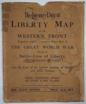
Published by Funk & Wagnalls Co., New York 1919
- Softcover
- Signed
Seller: Antipodean Books, Maps & Prints, ABAA, Garrison, NY, U.S.A.Antipodean Books, Maps & Prints, ABAA
Contact seller3-star sellerCondition: Used - Very good
US$ 138.00
US$ 10.00 shippingShips within U.S.A.Quantity: 1 available
Maps. Condition: Very good condition. Possibly second printing. Unusually with two maps and an index pamphlet charting the progress of W.W.I including boundaries for countries in the treaty at the conclusion of the war. In all 3 pieces inside a printed sleeve. The "Map Cloth Edition". "The Literary Digest Liberty Map of the West…ern Front of the Great World War: Showing the battle-Line of Liberty as it stood August 5th 1918". The map represents the Western Front in 1918 with the opposing troop positions indicated. Lower right hand corner has an inset map of the Complete War: The Western, Russian and Balkan Fronts, including Palestine and Mesopotamian Campaigns. In the upper right corner, an inset of occupied Belgium and Western Germany with iron and coal production figures for 1913-1918. Large folded color cloth edition map (42 " x 51 1/2"). "The Rand McNally New Europe", very interesting map of the whole of Europe with a printed Explanatory Key showing old Boundaries (in red)1914 & new boundaries "shown in tints" but dotted lines. There are 33 numbered entries with 4. Eupen and 5. Malmedy "To be decided by the League of Nations". The index also lists #"32. Armenia independence proclaimed August 1918 and #33. Bessarabia, to Roumania". Another key lists a " Summary of Treaty Terms given Austria." The Treaty of Saint-Germain, was signed on September 10th 1919 and came into force July 16th 1920. Paper map, printed in color, 25 3/4 x 19". Printed pamphlet "Index for The Literary Digest Liberty Map of the Western Front of the Great World War." 8vo, (ii), 32pp, printed wrappers. The printed sleeve has an added pastedown "at "The Frontier of Freedom". The presence of the second map along with the pastedown correction on the sleeve leads us to believe that this is a 1919 second edition.

Published by London: Barlow's General History of Europe 1780
- Signed
- Map
Seller: historicArt Antiquariat & Kunsthandlung, Wiesbaden-Breckenheim, , GermanyhistoricArt Antiquariat & Kunsthandlung
Contact seller5-star sellerCondition: Used
US$ 238.45
US$ 13.89 shippingShips from Germany to U.S.A.Quantity: 1 available
1. large original copper engraving with decorative plate borders on hand-made paper (verso blank), extremely detailed and fine map showing even smaller towns, rivers and lakes, image size ca. 32 x 41,5 cm, size of sheet ca. 37 x 43 cm, some very small tears at the extremities, otherwise clean and in remarkably good condition, ra…re and decorative map 2100 gr.

) / [Latest Map of Europe (with an overview of the national strength and defenses of the major powers)].
1936 Fuchida / Kodansha Map of European National Defenses, World War II
- Softcover
- Signed
- Map
Seller: Geographicus Rare Antique Maps, Brooklyn, NY, U.S.A.Geographicus Rare Antique Maps
Contact seller4-star sellerSoft cover. Very good. Size 30.75 x 42.5 Inches. This is a very rare and unusual Japanese portrayal of European military power by Fuchida Tadayoshi - illustrated to support Japanese interest in the increasingly tense situation in Europe, as well as to emphasize to the Japanese public the value of European alliances. It was publi…shed as a supplement to the January 1, 1936 (Showa 11), edition of King (???) magazine. The map, along with the included insets, charts, and graphs, describes the military and economic situation in Europe at the time and the relationship of Japan to the emerging European conflict. A Closer Look This map covers the western end of Eurasia, North Africa, the North Atlantic, and the eastern seaboard of Canada and the United States. Soldier figurines, ships, and airplanes represent the ground, sea, and air forces of the United States, Britain, France, Germany (in the North Sea), the Soviet Union, and Italy (in Libya), with the number of troops, ships, and planes written underneath the illustrations. Individual fleets of the various navies are also depicted with a ship outline and red text, noting the types and numbers of ships in each fleet. A note next to legend states that estimations of ground and air forces are based on a 1932 report by the League of Nations, but that military forces of Germany and the Soviet Union had expanded considerably since then. Several inset maps, charts, and tables provide all manner of information on international relations, trade, and economics. At top, over Greenland, a table lists alliances, treaties, and diplomatic agreements between European powers. At bottom-left are projections of (roughly) the Eastern and Western Hemisphere in 145000000 scale. A legend notes symbols indicating roads, railways, sea and air routes, ports, wireless telecommunications stations, cities of various sizes, Japanese consulates and embassies, and geographic features. Two inset maps sit below the legend: the map at right shows Europe's borders before the Great War, while the map at left shows the distribution of ethnicities and 'races' in Europe according to a color-coding system, with Latins as brown, 'Teutons' as red, Slavs as green, Celts as purple, and Asians as yellow. This map reveals the common acceptance of pseudoscientific racial categorizations and scientific racism in Japan at the time. To the right are a series of charts and diagrams with geographic and economic information, including, from top: a comparison of each country's land area, the total population and population density of each country, the national wealth of each country, each country's share of global shipping, and trade statistics for each country. Japan and, in most cases, the U.S. are also included in these tables, though the focus is on Europe. The circular diagram at bottom-right shows Japan's imports (at top) and exports (at bottom) with major European economies (based on 1934 statistics). Overall, Japan ran a trade deficit with Europe and its largest European trading partner was Britain, with whom it had a considerable trade surplus; Germany was a close second, with Japan importing much more than it exported to Germany. The Origins of the Second World War This map was produced at a time when Europe and the world began sliding towards a major conflict, though it did not necessarily appear that way at the time. In retrospect, Japan's invasion of Manchuria in 1931, gradual occupation of northern China in the mid-1930s, and increasing antagonism towards Great Britain and the United States were major antecedents to World War II in Asia. In Europe, in the months just prior to this map's publication, Italy had invaded Ethiopia and established the Rome-Berlin Axis with Nazi Germany (Japan was already negotiating behind closed doors to join the Axis). The major common factor tying the situations in Asia and Europe together was the Soviet Union, which both Japan and Germany viewed as a malign force dedicated to exporting Communism through. Signed by Author(s).
- Signed
Seller: Antique Paper Company, ASHFORD, KENT, United KingdomAntique Paper Company
Contact seller2-star sellerCondition: Used
US$ 172.71
US$ 8.05 shippingShips from United Kingdom to U.S.A.Quantity: 1 available
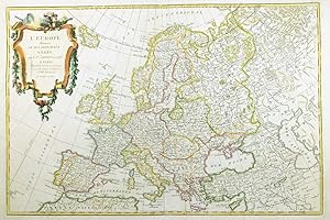
1762 A fine and rare original antique map titled ' L'EUROPE divisee en ses Principaux Etats ' PROVENANCE Taken from ATLAS MODERNE OU COLLECTION DE CARTES SUR TOUTES LES PARTIES DU GLOBE TERRESTRE c1775 by Jean Lattre This is a good exle of Jean Janvier's 1762 decorative map of the Europe. Janvier's map covers from Iceland to the… Caspian Sea and from North Africa to the Arctic. The map is divided into countries and kingdoms with color coding according to region. As a whole it offers excellent detail throughout showing mountains, rivers, forests, national boundaries, regional boundaries, forts, and cities. The scope of the map is worth noting, as it intentionally encompasses not just Europe but the extent of European cultural expansion into the surrounding areas. It is no error that the map extends westward to Portuguese Madeira and Porto Santo, nor northwards to embrace Iceland, nor that it extends eastward into the Russian dominated lands beyond the Caspian. This was the 'Greater Europe,' a vast region considered naturally part of Europe's cultural patrimony. A large decorative title cartouche appears in the upper left quadrant. CARTOGRAPHERS Jean or Robert Janvier (fl. 1746 - 1776) was a Paris based cartographer active in the mid to late 18th century. Janvier true first name is a matter of debate, as it appears as it often appears as either Jean or Robert. More commonly, Janvier simply signed his maps Signor Janvier. By the late 18th century Janvier seems to have been awarded the title of Geographe Avec Privilege du Roi and this designations appears on many of his latter maps. Janvier worked with many of the most prominent French, English and Italian map publishers of his day, including Faden, Lattre, Bonne, Santini, Zannoni, Delamarche, and Desnos. Jean Lattre (fl. 1743 - 1793) was a Paris based bookseller, engraver, and map publisher active in the mid to late 18th century. Lattre published a large corpus of m.


