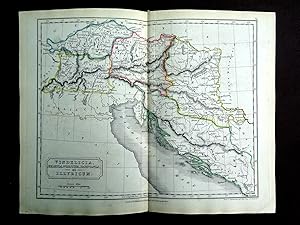
Map Illyricum (9 results)
Language: English
Published by Longman Brown Green and Longmans, London 1842
- Map
Seller: Tony Hutchinson, Seale, , United KingdomTony Hutchinson
Contact seller5-star sellerCondition: Used - Good
US$ 17.13
US$ 7.71 shippingShips from United Kingdom to U.S.A.Quantity: 1 available
No Binding. Condition: Good. An original 180 year old single sided map with hand coloured borders in nice condition, no deliberate marks, may have some light age staining commensurate with age - please see pic for this actual item. Single fold. 10.5 x 8.5 inch. Dr Samuel Butler was educated at Rugby School, became Headmaster of…Shrewsbury School, and later was appointed Bishop of Lichfield. He published works on the Ancient World from 1813 onwards.
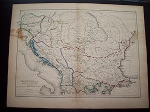
Published by Blanchard and Lea, Philadelphia, PA
- Map
Seller: Barry Cassidy Rare Books, Sacramento, CA, U.S.A.Barry Cassidy Rare Books
Contact seller5-star sellerCondition: Used - Very good
US$ 50.00
US$ 6.00 shippingShips within U.S.A.Quantity: 1 available
No Binding. Condition: Collectible-Very Good. Original publisher's hand-colored map of the ancient regions of Macedonia, Thracia, and Illyricum as wells as Dacia, Pannonia, Thessalia, and Moesia. In the four corners beginning in the upper-left and going clockwise are parts of the following regions: Rhaetia and Germania, Sarmatia…, Asia Minor, and Italia (Italy). Features beautiful watercolored outlines in blue, green, pink, and yellow around country or regional borders. Major cities and natural features such as mountains, rivers, and seas are shown. Scales of distance in Roman and English miles included. No date, circa 1836-1851. Map with margins measures 13 1/4" x 10"; actual map area measures 11 1/2" x 8 3/8." Map is very clean and intact except for slight foxing and a faded stain in the upper-left that enters about 1/2" into the map area. The center fold line is original as this map originally came from an atlas. Lines of latitude and longitude also included. The following is printed beneath the map: "Philadelphia, Blanchard & Lea." and "Eng. by G. E. Sherman, N.Y." "14" printed in upper-right corner outside of the neatline. Blanchard & Lea (fl. c. 1836-1851) was a Philadelphia-based publishing house and successor to Matthew Carey & Company. George E. Sherman was an American map engraver based in New York and co-founder of the publishing firm, Sherman & Smith or Stiles, Sherman & Smith (fl. c. 1829-1855).

Published by [London?] c.1780?, [London?] 1780
Seller: High Ridge Books, Inc. - ABAA, South Deerfield, MA, U.S.A.High Ridge Books, Inc. - ABAA
Contact seller5-star seller21x27 cm. Uncolored map, removed from a late 18th century geography or history. Printed on laid paper with chain marks and an undated watermark. Fine condition. Shows the Dalmatian coast of the Adriatic Sea, apparently during the Roman Period as the place names are mostly in Latin. Extends north to show some of the Danube River.… There are no publishing credits, but at the top are indications of its original location in a set of books: Vol. IV, Plate II, Page 180.
 More images
- Map
Seller: RareMapsandBooks, Dover, NH, U.S.A.RareMapsandBooks
Contact seller4-star sellerCondition: Used - Good
US$ 37.50
US$ 6.95 shippingShips within U.S.A.Quantity: 1 available
Condition: good. Roman Provinces of Pannonia, Illyricum, Dacia, Moesia, &c.(Europe, Balkans, Roman Empire, Provinces, Pannonia, Illyricum, Dacia, Moesia, Hungary, Wallachia, Bulgaria, Dalmatia). Issued 1855, Liverpool by George Philip & Sons. Oversized mid 19th century engraved historical map with original hand color. Nice looki…ng example, pleasing age patina, any minor age flaws easy to overlook or forgive. Original center fold as issued. Sheet Measures c.11" H x 28" W. Engraved Area Measures c. 20" H x 23 3/4" W. Cartographic Reference (s):Tooley'sà Dictionary of Mapmakers, vol. 3.[R23051].
Published by Geographisches Institut Weimar
- Hardcover
Seller: Hammelburger Antiquariat, Hammelburg, , GermanyHammelburger Antiquariat
Contact seller5-star sellerCondition: Used - Very good
US$ 152.89
US$ 34.52 shippingShips from Germany to U.S.A.Quantity: 1 available
Hardcover. Condition: very good. Illyricum/Isonzo/Soca, anno 1807, map by Geograph.Institut Weimar, size of the leaf: 40x52 cm.

Language: Italian
Published by Brescia 1599
- Map
Seller: Antiquariat Steffen Völkel GmbH, Seubersdorf, GermanyAntiquariat Steffen Völkel GmbH
Contact seller5-star sellerCondition: Used
US$ 59.25
US$ 34.52 shippingShips from Germany to U.S.A.Quantity: 1 available
Size of sheet: c. 21,3 x 15 cm. -- Original engraved map from 1599 out of G. Botero's "Relationi Universali". With Italian text recto and verso. -- in very good condition. || Original Kupferstich-Karte von 1599. Auf ganzer Textseite mit italienischem Text.- gut erhalten. // Wir, das Antiquariat Steffen Völkel, kaufen und verkauf…en alte Bücher, Handschriften, Zeichnungen, Autographen, Grafiken und Fotografien. Wir sind stets am Ankauf von kompletten Bibliotheken, Sammlungen und Nachlässen interessiert. Sprache: Italienisch Gewicht in Gramm: 10.

Published by Artist: Wells Edward ( - 1727 ) London ca : 1700 1667
Seller: Antique Sommer& Sapunaru KG, München, , GermanyAntique Sommer& Sapunaru KG
Contact seller4-star sellerCondition: Used
US$ 450.37
US$ 51.78 shippingShips from Germany to U.S.A.Quantity: 1 available
Technic: Copper print, colorit: colored, condition: Tear external margin perfectly restored, size (in cm): 36 x 49, Decorative map of Greece with its islands (Crete) an a title cartouche.
 More images
Published by Ortelius Abraham, 1527-1598 1595
- Map
Seller: Hammelburger Antiquariat, Hammelburg, , GermanyHammelburger Antiquariat
Contact seller5-star sellerCondition: Used - Very good
US$ 674.37
US$ 34.52 shippingShips from Germany to U.S.A.Quantity: 1 available
Kein Einband. Condition: Gut. Illyricum, Croatia, Histria, anno 1595, Ortelius, map, good cond Coppermap, edited by Abraham Ortelius, Theatrum orbis terrarum, latin edition, anno 1595. Plate size: 370 x 479 mm., very good condition, printed on thick paper, wide margins, clean, no cracs on centerfold. Reference: vdB Nr. 144.

Seller: Bartele Gallery - The Netherlands, Langweer, FRL, NetherlandsBartele Gallery - The Netherlands
Contact seller5-star sellerCondition: Used
US$ 402.96
US$ 19.56 shippingShips from Netherlands to U.S.A.Quantity: 1 available
Antique miniature map titled 'Illyricum'. Original small map of Illyricum. The Roman province of Illyricum stretched from the Drilon River (the Drin, in modern Albania) in the south to Istria (modern Slovenia and Croatia) in the north and to the Savus (Sava) River in the east; its administrative centre was Salonae (near present-…day Split) in Dalmatia. With the extension of the Roman Empire along the Danube River valley, Illyricum was divided between the provinces of Dalmatia and Pannonia. This print originates from 'Epitome theatri orbis terrarum' by A. Ortelius. Published 1612.


