Order Total (1 Item Items):
Shipping Destination:

Map Mississippi, Signed (3 results)
Skip to main search results
Search filters
Product Type
- All Product Types
- Books (2)
- Magazines & Periodicals (No further results match this refinement)
- Comics (No further results match this refinement)
- Sheet Music (No further results match this refinement)
- Art, Prints & Posters (No further results match this refinement)
- Photographs (No further results match this refinement)
- Maps (1)
- Manuscripts & Paper Collectibles (No further results match this refinement)
Condition Learn more
- New (No further results match this refinement)
- As New, Fine or Near Fine (No further results match this refinement)
- Very Good or Good (1)
- Fair or Poor (No further results match this refinement)
- As Described (2)
Binding
- All Bindings
- Hardcover (No further results match this refinement)
- Softcover (No further results match this refinement)
Collectible Attributes
- First Edition (1)
- Signed (3)
- Dust Jacket (No further results match this refinement)
- Seller-Supplied Images (3)
- Not Print on Demand (3)
Language (2)
Price
- Any Price
- Under US$ 25 (No further results match this refinement)
- US$ 25 to US$ 50 (No further results match this refinement)
- Over US$ 50
Free Shipping
- Free Shipping to U.S.A. (No further results match this refinement)
Seller Location
Seller Rating
-
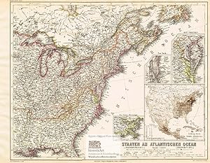
Staaten am Atlantischen Ozean. Large map of the Eastern States of the United States of America on the Atlantic Ocean with small inside maps of New York, Eastern Virginia and the Lower Mississippi. Colored steel engraving by Plath after Ravenstein from Meyer's Hand-Atlas 1867
Language: German
Published by Hildburghausen: Bibliographischen Instituts, 1867
Seller: historicArt Antiquariat & Kunsthandlung, Wiesbaden-Breckenheim, Germany
Seller rating 5 out of 5 stars

Map First Edition Signed
1. gro�er Original-Stahlstich von Plath (in der Platte signiert) auf r�ckseitig unbedrucktem B�ttenblatt aus Meyer's Hand-Atlas 1867, im Druck und von Hand sehr pr�zise grenzkoloriert, bildliche Darstellung ca. 34 x 43 cm, Blattgr��e ca. 37 x 48 cm (jeweils H�he x Breite), sauber und sehr gut erhalten - gro�er und/oder schwerer Artikel mit zus�tzlichen Kosten f�r Versand und Versicherung - heavy and/or oversized item with additional costs for shipping and insurance - will be dispatched enrolled in a solid mailing tube - please ask us before you order this article 2100 gr.
-
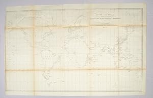
Chart of the World shewing the Track of the U.S. Steam Frigates, Mississippi, Susquehanna and Powhatan as Flagships of the Japan Squadron under the command of Commodore M.C. Perry, U.S.N., 1853-54 World Map 1854
Published by Hydrographic Office c1854., United States., 1854
Seller: Asia Bookroom ANZAAB/ILAB, Canberra, ACT, Australia
Association Member: ANZAAB ILAB
Seller rating 5 out of 5 stars
Signed
Large black and white folded map. Some browning at the folds, some fold lines have been repaired with archival tape but overall in good condition. Scale 1:37,000,000. 54 x 91 cm "In January 1852 Perry was selected to undertake the most important diplomatic mission ever entrusted to an American naval officer, the negotiation of a treaty with Japan, a country at this time sealed against intercourse with the Occidental powers" (DAB). By March 31, 1854, the treaty granting the U.S. trading rights had been signed by the Japanese. Drawn by Edward. Sels and engraved by Selmar Siebert this map was issued as part of the United States Naval Expedition to Japan, 1852-1854. Shows the route of the US Steam Frigates Mississippi, Susquehanna and Powhatan. Some regions such as Antarctica and Enderbury's Land appear to be un-explored, Tasmania appears at Van Diemen's Land.
-
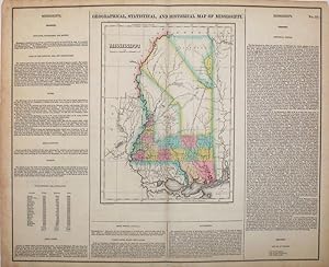
Geographical, Statistical, and Historical Map of Mississippi
Published by Philadelphia, 1823
Seller: Antipodean Books, Maps & Prints, ABAA, Garrison, NY, U.S.A.
Association Member: ABAA ANZAAB ESA ILAB
Seller rating 3 out of 5 stars

Signed
Condition: Very good condition. Fine original hand colored map of Mississippi from Carey and Lea's 'A Complete Historical, Chronological, and Geographical American Atlas, being a Guide to the History of North and South America, and the West Indies . to the Year 1822', the best atlas of nineteenth century America. With text on two sides and below map, pertaining to topography, climate, lands, towns & rivers, 'Indian Country', public lands, roads & canals, government and history. This map, according to History Detectives (Season 6, Episode 4: Lincoln Forgery) was evidently part of an Abraham Lincoln memorabilia scam in which a forger named Harry Sickles worked with Eugene Field II to pass off items in Field's collection as Lincoln items. Sickles and Field managed to convince William P. Brown, the still living coachman of Abraham Lincoln, that they wanted his signature on the verso of their items. Brown's signature, and the notary's signature are genuine; the text referring to the map being given by Mrs. Lincoln to Brown in 1866 was added by the forger. This is the handwritten note on the verso: "This is from the collection of old books, papers, maps, etc presented to her coachman, Wm. P Brown, by Mrs. Lincoln in 1866. (Signed) Wm P Brown. The signatures are genuine. (Signed) Frank E. Thatcher". There is a blue notary stamp, (Muskegon County, Mich. 1933) and a circular blind stamp. Howes C133; Phillips 1373a; Wheat, Mapping of the Transmississippi West 2:81. Image size: 20 3/4 x 16 1/2" on paper 22 1/4 x 17 1/2".