Map Nevada: First Edition (33 results)

Published by Nevada Bureau O F Mine and Geology, Reno, Nevada 2013
- Softcover
- First Edition
Seller: Crossroads Books, Reno, NV, U.S.A.Crossroads Books
Contact seller5-star sellerCondition: Used - Very good
Original price: US$ 21.00; 25% offCurrent price: US$ 15.75
US$ 5.05 shippingShips within U.S.A.Quantity: 1 available
Paperback. Condition: Very Good. First Edition; First Printing. The 1: 24,000-scale geologic map of the Flowery Peak quadrangle is an extension of mapping published recently by the Nevada Bureau of Mines and Geology in the adjacent Virginia City quadrangle. The Flowery Peak quadrangle, southeast of Reno and east of Virginia City…, includes part of the Comstock mining district, an important historic source of precious metals. More than 60 lithologic units were mapped in the Flowery Peak quadrangle. Twenty-six units are in the three major mid-Miocene intermediate magmatic groups defined in the Virginia City quadrangle. Extensive Quaternary sedimentary deposits include eighteen units exposed in the Carson River Plains in the southeast part of the Flowery Peak quadrangle. Minor amounts of mid-Miocene sedimentary rocks, early Miocene and Oligocene ash-flow tuffs, late Miocene basalt, and Quaternary rhyolitic rocks are present. Mesozoic metasedimentary and granitic rocks occur as well. Mapping of hydrothermal veins and associated alteration in the Flowery Peak quadrangle extends similar mapping in the Virginia City quadrangle. Twelve new 40Ar/39Ar ages determined for igneous rocks in the Flowery Peak quadrangle, along with chemical and mineralogic data, are reported in text that accompanies the map along with full unit descriptions. This map was prepared as part of the STATEMAP component of the National Cooperative Geologic Mapping Program in cooperation with the U. S. Geological Survey. The 1: 24,000-scale geologic map of the Flowery Peak quadrangle is an extension of mapping published recently by the Nevada Bureau of Mines and Geology in the adjacent Virginia City quadrangle. The Flowery Peak quadrangle, southeast of Reno and east of Virginia City, includes part of the Comstock mining district, an important historic source of precious metals. More than 60 lithologic units were mapped in the Flowery Peak quadrangle. Twenty-six units are in the three major mid-Miocene intermediate magmatic groups defined in the Virginia City quadrangle. Extensive Quaternary sedimentary deposits include eighteen units exposed in the Carson River Plains in the southeast part of the Flowery Peak quadrangle. Minor amounts of mid-Miocene sedimentary rocks, early Miocene and Oligocene ash-flow tuffs, late Miocene basalt, and Quaternary rhyolitic rocks are present. Mesozoic metasedimentary and granitic rocks occur as well. Mapping of hydrothermal veins and associated alteration in the Flowery Peak quadrangle extends similar mapping in the Virginia City quadrangle. Twelve new 40Ar/39Ar ages determined for igneous rocks in the Flowery Peak quadrangle, along with chemical and mineralogic data, are reported in text that accompanies the map along with full unit descriptions. This map was prepared as part of the STATEMAP component of the National Cooperative Geologic Mapping Program in cooperation with the U. S. Geological Survey. The 1: 24,000-scale geologic map of the Flowery Peak quadrangle is an extension of mapping published recently by the Nevada Bureau of Mines and Geology in the adjacent Virginia City quadrangle. The Flowery Peak quadrangle, southeast of Reno and east of Virginia City, includes part of the Comstock mining district, an important historic source of precious metals. More than 60 lithologic units were mapped in the Flowery Peak quadrangle. Twenty-six units are in the three major mid-Miocene intermediate magmatic groups defined in the Virginia City quadrangle. Extensive Quaternary sedimentary deposits include eighteen units exposed in the Carson River Plains in the southeast part of the Flowery Peak quadrangle. Minor amounts of mid-Miocene sedimentary rocks, early Miocene and Oligocene ash-flow tuffs, late Miocene basalt, and Quaternary rhyolitic rocks are present. Mesozoic metasedimentary and granitic rocks occur as well. Mapping of hydrothermal veins and associated alteration in the Flowery Peak quadrangle extends similar mapping in the Virginia City quadrangle. Twelve new 40Ar/39Ar ages determined for igneous rocks in the Flowery Peak quadrangle, along with chemical and mineralogic data, are reported in text that accompanies the map along with full unit descriptions. This map was prepared as part of the STATEMAP component of the National Cooperative Geologic Mapping Program in cooperation with the U. S. Geological Survey. Supersedes Open-File Reports 05-4 and 06-16. Plate: 35 x 31.5 inches, scale 1: 24,000, color, with 3 cross sections; , ; NBMG Map 180; Textbook; Vol. 180; Color Illustrations; 4to 11" - 13" tall; 1 pages MS1.

Published by U.S. Geological Survey, Washington 1987
- Softcover
- First Edition
Seller: Quickhatch Books, Ottawa, ON, CanadaQuickhatch Books
Contact seller5-star sellerCondition: Used - Very good
US$ 10.00
US$ 14.00 shippingShips from Canada to U.S.A.Quantity: 1 available
Soft cover. Condition: Very Good. First. Folding map in manilla sleeve, some textual material, references. Scale 1:50,000. Miscellaneous Field Studies Map MF-1971. Ex-institutional reference collection, light wear to sleeve. Book.
 More images
Published by Nevada Bureau of Mines and Geology, Usa 1980
- Softcover
- First Edition
Seller: Spellbinder Books, Bishop, CA, U.S.A.Spellbinder Books
Contact seller5-star sellerCondition: Used - Good
US$ 19.98
US$ 6.50 shippingShips within U.S.A.Quantity: 1 available
Paperback. Condition: Good. First Edition; First Printing. Stated 1st edition and 1st printing. Good paperback with tight binding and clean pages. A small section at the top of the spine is missing about 1/2-inch in length. Minor wear to the rest of the edges and corners of cover and spine. Bottom left corner of the back cover i…s creased. Back cover has one large scuff mark in the bottom left corner as well and lighter scuff marks on the rest of the cover. ; 4to 11" - 13" tall; 136 pages.
Published by U.S. Geological Survey, Washington 1987
- First Edition
Seller: Quickhatch Books, Ottawa, ON, CanadaQuickhatch Books
Contact seller5-star sellerCondition: Used - Very good
US$ 10.00
US$ 14.00 shippingShips from Canada to U.S.A.Quantity: 1 available
Condition: Very Good. First. U.S. Geological Survey, Miscellaneous Field Studies Map, MF-1998. 1:62,500. Map includes textual material, biblio. references, tables, in original sleeve, VG ex-reference library with minimal library flaws. Book.
Published by California State Library Government Publications Section 1969
- Softcover
- First Edition
Seller: Arader Galleries of Philadelphia, PA, Philadelphia, PA, U.S.A.Arader Galleries of Philadelphia, PA
Contact seller4-star sellerCondition: Used - Very good
US$ 32.00
US$ 4.50 shippingShips within U.S.A.Quantity: 1 available
Softcover. Condition: Very Good. First Edition. Very good condition. Slight fading on front cover. Clean text, most likely never read before. Book is staple bound. original 1969 printing.
 More images
Published by Hartford Publishing Company, Hartford, CT 1869
- Hardcover
- First Edition
Seller: BIBLIOPE by Calvello Books, Oakland, CA, U.S.A.BIBLIOPE by Calvello Books
Contact seller4-star sellerHardcover. Hardcover quarto with leather boards and missing spine. 524 pages: frontispiece (portraits), illustrations, map; 23 cm. Introductions by Colfax, Schuyler and Bross, William. Abstract: Details the author's journeys and experiences across the North American continent in the summers of 1865 and 1866, exploring the Wester…n United States.9707. Binder's copy. Acceptable. Boards still attached though shaken. Spine wrap is missing. Moderate rubbing to edges and corners of leather boards. Mild fraying and bumping to corners of boards. Front and back boards are loose at hinge. Mild spotting to end papers. Moderate foxing to prelimniariesand edges of text block. First Edition (presumed; no prior editions or printings cited).
Published by US Geol Survey, Wash, DC 1885
- Softcover
- First Edition
Seller: Larry W Price Books, Portland, OR, U.S.A.Larry W Price Books
Contact seller5-star sellerCondition: Used - Very good
US$ 39.50
US$ 4.95 shippingShips within U.S.A.Quantity: 1 available
Pamphlet. Condition: Very Good. 1st Edition. From: Monographs of the US Geol Surv,Vol 11, Lge Color FoldOut Map Only from the pocket of this Book), 20 X 33 Inches, Color Fold Out Map, Folds to 8 x 10 Inches, VG, 1st ed (Beautiful Fresh Condition).
 More images
Published by Macmillan and Co., London 1890
- Softcover
- First Edition
Seller: Bailgate Books Ltd, Doncaster, , United KingdomBailgate Books Ltd
Contact seller5-star sellerCondition: Used - Very good
US$ 35.47
US$ 19.50 shippingShips from United Kingdom to U.S.A.Quantity: 1 available
Softcover. Condition: Very Good. No Dust Jacket. First Edition. Single disbound coloured map sheet, from John Bartholomew's Library Reference Atlas, covering part of the United States of America. Suitable for framing. Approx size 46 x 35 cm, horizontal centre fold. Map is clean, crisp, clear and bright. Sheet covers the part of…USA or the 'Pacific States' including: California, Nevada, Oregon, Washington, Idaho, Utah, Arizona, part of Montana and Wyoming, Santa Barbara, San Francisco, Sacramento, Prescott, Salt Lake City, Carson City, Yellowstone, Salem, Olympia and San Diego. No dust jacket, as published. Quantity Available: 1. Shipped Weight: under 1 kg. Pictures of this item not already displayed here available upon request. Inventory No: 45020124071. All our books are sent by tracked mail.

Published by U.S. Geological Survey., Washington. 1961
- Softcover
- First Edition
Seller: BookMine, Fair Oaks, CA, U.S.A.BookMine
Contact seller4-star sellerSoft cover. First edition. Large, folding map. Important reference work. Very scarce in this condition. Fine copy in fine envelope.
Language: English
Published by New York 1861
- First Edition
Seller: Clayton Fine Books, Shepherdstown, WV, U.S.A.Clayton Fine Books
Contact seller4-star sellerCondition: Used - Near fine
US$ 85.00
US$ 6.00 shippingShips within U.S.A.Quantity: 1 available
Disbound. Condition: Near Fine. First Edition. Complete, original disbound issue in very good condition with edgewear and chipping and wear one lower corner.
Published by S. Augustus Mitchell, Philadelphia 1867
- First Edition
- Map
Seller: T. W. Palmer Books, Eugene, OR, U.S.A.T. W. Palmer Books
Contact seller5-star sellerCondition: Used - Near fine
US$ 75.00
US$ 4.00 shippingShips within U.S.A.Quantity: 1 available
No Binding. Condition: Near Fine. No Jacket. 1st Edition. 32 x 40 cm, colored counties, numerous well labeled roads and trails, verso blank, grape border, #49, "drawn ad engraved by W. H. Gamble Pholadelphia" top slightly nicked, otherwise fine.

Language: English
Published by [Rand McNally], [Chicago] 1881
- First Edition
Seller: Kaaterskill Books, ABAA/ILAB, East Jewett, NY, U.S.A.Kaaterskill Books, ABAA/ILAB
Contact seller5-star sellerImage size 23.5 x 19.14 inches on 24.5 x 20.5 sheet. Outlined color. Relief shown by hachures and spot heights. An extremely detailed, if not the most detailed map of California and Nevada up to that time to be published in an Atlas. Shown are many hundreds of natural and man-made features such as mountains, rivers, lakes, sprin…gs, wells, lava fields, deserts, plains, craters, dry lakes, passes, as well as military encampments, mines, Native American Reservations, roads, railroads and stations, canals, ferry crossings, Missions, cities, towns, and other human habitations, many of which are long gone. Removed from the Rand McNally's Indexed Atlas of the World, first edition, 1881. A very good copy, some edge tears, one closed tear about 1/2 inch into blank area of map, one small hole at fold, generous margins.
Published by Nevada Bureau of Mines & Geology:, Reno, Nevada 1980
- Softcover
- First Edition
Seller: Charles Lewis Best Booksellers, San Diego, CA, U.S.A.Charles Lewis Best Booksellers
Contact seller5-star sellerPaperback. First Edition. Demy folio, [27.75cm/11in], paperbound with pictorial covers, pp. 136. Fully illustrated with colored maps as well as b-w halftones.Includes 50 maps, mostly in color, a few cross-sections & 61 b-w halftones. In exceptionally good condition.
Published by R.R. Donnelley and Sons Co, Chicago 1889
- Hardcover
- First Edition
Seller: Ziern-Hanon Galleries, Frontenac, MO, U.S.A.Ziern-Hanon Galleries
Contact seller1-star sellerCondition: Used - Good
US$ 149.50
US$ 5.50 shippingShips within U.S.A.Quantity: 1 available
Full Cloth. Condition: Good. First Edition. FIRST EDITION, first printing. Complete with two folding maps, one of which is full color. Full brown cloth with stamped black design and lettering on the front cover and the spine, light wear, decorative endpapers. Front free endpaper is loose with the webbing starting at the gutter.…Large color folding map of Colorado, Utah, Arizona and California. Small black & white folding map of Colorado. Railroad name & city stamped on the front endpaper. Map Sizes: 10" x 7" (for the small b&w) and 20" x 14" (for the color). Pages age toned. Overall in GOOD condition. Photos available upon request. Size: 8vo - over 7¾" - 9¾" tall. Hardcover.
 More images
Published by Issued by The Department of Highways, Carson City, NV 1929
- Hardcover
- First Edition
Seller: Tavistock Books, ABAA, Reno, NV, U.S.A.Tavistock Books, ABAA
Contact seller5-star sellerSingle sheet, folded 3x. Verso: map. Recto: 8 panels with divers text announcements, including "Digest of Motor Vehicle Laws" & "Miscellaneous Distances". Map: 21-3/4" x 17". Folded: 8-1/2" x 5-1/2'. The NV Department of Highways was founded in 1917 with the mission "to surface what were often rutted dirt paths forged by pioneer…s." Other historical highlights of the Department include: ⢠January 1919. The Department's 1st major construction project was to build a trestle bridge over the Humboldt River in Pershing County at a cost of $10,953. Also in 1919, a $72,000 project kicked off to build a concrete roadway from Reno to ~ 6 miles south. ⢠in the mid 1920s, the states 45 mph speed limit was rescinded, and replaced with speed guidelines of limiting vehicle speeds to that of "sane and safe driving." ⢠1923. A gasoline tax was instituted, providing another vital source of funding for transportation projects. ⢠1929. the last NV link of U. S. Highway 91 near Apex was oiled, providing a smooth roadway surface from California across Nevada between California and Arizona. In later years, it would pave the way for Nevada's busiest interstate, I-15, which now traverses alongside the iconic Las Vegas Strip. OCLC records 3 holding institutions for this map, surprisingly enough, none in Nevada. Age-toning, with minor edge rash. Some short tears at the folds. A VG copy. Now housed in an archival mylar sleeve 1st printing thus [i.e., this year], and apparently the NV Dept of Highway's 4th map overall, the first coming in 1919, followed by 1922 & 1927 [this latter also overseen by Durkee].
 More images
Published by California State Automobile Association, San Francisco 1917
- Softcover
- First Edition
Seller: Currey, L.W. Inc. ABAA/ILAB, Elizabethtown, NY, U.S.A.Currey, L.W. Inc. ABAA/ILAB
Contact seller4-star sellerMap cover title is "OFFICIAL HIGHWAY MAP OF CALIFORNIA AND WESTERN NEVADA 1917 COPYRIGHTED AND PUBLISHED BY CALIFORNIA STATE AUTOMOBILE ASSOCIATION 1628 VAN NESS AVENUE SAN FRANCISCO, CAL." Large color pocket map, 98x38.5 cm (approximately 37 3/4 x 14 1/4 inches), printed in four colors on architectural linen. Folded into tan wr…appers (20x13 cm; 7 7/8 x 5 1/8 inches) with a Southern Pacific advertisement on the inside front cover offering a "choice of four routes across America" and a full-color illustration of a Shell Oil of California gas station on the rear panel. The map shows county boundaries, cities and towns, highways and roads, wagon roads, railroads, rivers and streams, etc. The rare first printing of this attractive highway map of California and Western Nevada. OCLC reports one copy of the 1917 issue (The David Rumsey Map Center, Stanford University). (#168615). The map has tiny closed tears at several intersections but is otherwise fine; the wrappers show some soiling and the overlapping edges are worn. (#168615).
 More images
Published by San Francisco Sierra Club 1896 1896
- Softcover
- First Edition
Seller: Aquila Books(Cameron Treleaven) ABAC, Calgary, AB, CanadaAquila Books(Cameron Treleaven) ABAC
Contact seller3-star sellerCondition: Used - Very good
US$ 1,585.86
US$ 19.00 shippingShips from Canada to U.S.A.Quantity: 1 available
Condition: very good. 1st Edition. Tall, stiff card, printed wrapper. (11.3 X 25.7 cm.) Housed within is a large folding black and white map. (100 X 100 cm.) Both map and folder are in excellent condition. Publications of the Sierra Club Number 12. Very scarce. An interesting and large scale map early map of the area. the map wa…s produced in this format as well at mounted on linen between covers and as a separate wall map as well.

- First Edition
Seller: Art Source International Inc., Boulder, CO, U.S.A.Art Source International Inc.
Contact seller5-star sellerRand McNally & Company, still a major name in map publishing to this day, began as a small print shop opened in Chicago in 1856 by William H. Rand. The shop originally printed guidebooks and directories. In 1858, Rand hired Andrew McNally who was later to become a partner. Within the next few years, the shop got into the railroa…d business by starting to print railway tickets and schedules, a key step in the development of the company. The ticket printing led to the publishing of railway guides, and by 1872 Rand McNally and Company had the capacity to publish maps. This map of Nevada came from Rand McNallys Commercial Atlas, sixty-first Edition dated 1930. A highly successful run of atlases that lasted over a decade. These maps were primarily used by business, because of their accurate listing of railroads in operation as well as tables of statistical information. This map is unique in several ways, their large format makes an impressive display, and offers additional room where many small towns and extra details are included. Additionally a list of every railroad operating in the state in 1930 is included. All railroad routes are shown on the map. This map includes all cities and towns, lakes, rivers, and bodies of water. All topographical features are also included as well as political features such as counties and Native American Indian reservations. This map measures 19 inches by 26 inches.
Published by S. Augustus Mitchell, Philadelphia 1870
- First Edition
- Map
Seller: T. W. Palmer Books, Eugene, OR, U.S.A.T. W. Palmer Books
Contact seller5-star sellerCondition: Used - Fine
US$ 100.00
US$ 4.00 shippingShips within U.S.A.Quantity: 1 available
No Binding. Condition: Fine. No Jacket. 1st Edition. 32 x 40 cm, colored counties, numerous well labeled roads and trails, verso blank, grape border, #52, "drawn and engraved by W. H. Gamble Pholadelphia" otherwise fine Differs from 1869 (#1919) at least by a larger Nye County and smaller Lincoln County both in Nevada.
 More images
Published by Rand McNally & Co., n.d [ca 1948]. ca 1948, Chicago 1948
- First Edition
Seller: BUCKINGHAM BOOKS, ABAA, ILAB, IOBA, GREENCASTLE, PA, U.S.A.BUCKINGHAM BOOKS, ABAA, ILAB, IOBA
Contact seller5-star sellerFirst edition thus. 19 1/2" x 32 1/4" sheet folded to 9 3/4" x 4 1/2." Double-sided color lithograph maps. Nicely produced Pictorial Map of California & Nevada featuring pictographs of places of interest and tourist spots throughout the west, including Las Vegas as only mine & mill, cotton fields in the San Joaquin Valley, and v…iews around Yosemite, as well as California Missions. Also featured are inset maps for San Francisco and Los Angeles, as well as large highway map on verso, inset tables for Western mileage and radio stations. Light rubbing to creases. Very good plus.
 More images
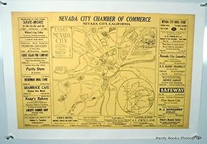
Published by Nevada City Chamber of Commerce, Nevada City, California 1929
- First Edition
Seller: Hardy Books, Nevada City, CA, U.S.A.Hardy Books
Contact seller5-star sellerCondition: Used - Near fine
US$ 155.00
US$ 4.95 shippingShips within U.S.A.Quantity: 1 available
Condition: Near Fine. First Edition. This is an ORIGINAL map of Nevada City, California, published by the Nevada City Chamber of Commerce in 1939. Linen mounted.The image measures 22 1/8" x 33 7/8". The overall piece, with linen border, measures 26" x 38". The map is central, surrounded by border advertisements of local establis…hments, most of which are now gone. The map was drawn by H. P. Davis, the author of "Gold Rush Days in Nevada City". In addition to a scale map of city streets, Davis has added small drawings and text regarding significant historical facts. Nevada City is the County Seat of Nevada County, California, in the gold country of the Sierra foothills. Running through the center of town is Deer Creek, the site of the earliest gold finds. The city was formally founded in March 1850, and named "Nevada", but had to add the word "City" when Nevada became a State. The richest deep quartz-gold mines in California are found in this area, principally in adjoining Grass Valley. Minor restoration and linen mounting by Innis Archives. Near Fine overall. Very scarce.
 More images
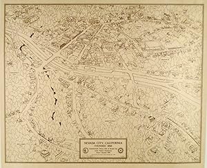
Published by The Rotary Club of Nevada City, Nevada City, California 1975
- First Edition
- Signed
Seller: Hardy Books, Nevada City, CA, U.S.A.Hardy Books
Contact seller5-star sellerCondition: Used - Fine
US$ 250.00
US$ 4.95 shippingShips within U.S.A.Quantity: 1 available
Condition: Fine. First Edition. This is an ORIGINAL 1975 Map of Nevada City, California by Artist Robert Chrestensen. SIGNED by Artist Christensen. Linen Mounted. This is a three dimensional map, with principal buildings drawn to scale. This is #10 of 25 signed copies. Nevada City, California is the County seat of Nevada County…California. At one time in the California Gold Rush, it was the third largest City in California, behind only San Francisco and Sacramento. It is in the heart of the California Northern Mines gold country. The image measures 21 1/2" x 27 1/4". The total piece, with white linen border, measures 26 1/4" x 30". Fine condition and certainly suitable for framing. Shipped rolled.
 More images
Published by Forest Service United States Deptartment of Agriculture 1919
- First Edition
- Map
Seller: Ernestoic Books, Clarence, NY, U.S.A.Ernestoic Books
Contact seller5-star sellerMeasuring approximately 13" x 7.75" with large fold out map. This proclamation is in very good condition. Minor sunning to all edges. Large fold out map intact and clean. Please view the many other rare titles available for purchase at our store. We are always interested in purchasing individual or collections of fine books. Inv…entory # (P1-43).
 More images
Published by Forest Service United States Deptartment of Agriculture 1918
- First Edition
- Map
Seller: Ernestoic Books, Clarence, NY, U.S.A.Ernestoic Books
Contact seller5-star sellerMeasuring approximately 13" x 7.75" with large fold out map. This proclamation is in very good condition. Minor staining to all edges. Large fold out map intact and clean. Please view the many other rare titles available for purchase at our store. We are always interested in purchasing individual or collections of fine books. In…ventory # (P1-26).
 More images
Published by Forest Service United States Deptartment of Agriculture 1919
- First Edition
- Map
Seller: Ernestoic Books, Clarence, NY, U.S.A.Ernestoic Books
Contact seller5-star sellerMeasuring approximately 13" x 7.75" with large fold out map. This proclamation is in very good condition. Minor staining to all edges. Large fold out map intact and clean. Please view the many other rare titles available for purchase at our store. We are always interested in purchasing individual or collections of fine books. In…ventory # (P1-25).
 More images
Published by Forest Service United States Deptartment of Agriculture 1919
- First Edition
- Map
Seller: Ernestoic Books, Clarence, NY, U.S.A.Ernestoic Books
Contact seller5-star sellerMeasuring approximately 13" x 7.75" with large fold out map. This proclamation is in very good condition. Minor bumping to all edges. Large fold out map intact and clean. Please view the many other rare titles available for purchase at our store. We are always interested in purchasing individual or collections of fine books. Inv…entory # (P1-24).
 More images
Published by Forest Service United States Deptartment of Agriculture 1919
- First Edition
- Map
Seller: Ernestoic Books, Clarence, NY, U.S.A.Ernestoic Books
Contact seller5-star sellerMeasuring approximately 13" x 7.75" with large fold out map. This proclamation is in very good condition. Minor staining to all edges. "1509" written in red colored pencil on top right corner of front. Large fold out map intact and clean. Please view the many other rare titles available for purchase at our store. We are always i…nterested in purchasing individual or collections of fine books. Inventory # (P1-23).
 More images
Published by Forest Service United States Deptartment of Agriculture 1919
- First Edition
- Map
Seller: Ernestoic Books, Clarence, NY, U.S.A.Ernestoic Books
Contact seller5-star sellerMeasuring approximately 13" x 7.75" with large fold out map. This proclamation is in very good condition. Minor staining and bumping to all edges. Large fold out map intact and clean. Please view the many other rare titles available for purchase at our store. We are always interested in purchasing individual or collections of fi…ne books. Inventory # (P1-22).

Published by Publisher Not Stated, UK 1902
- First Edition
- Map
Seller: RareNonFiction, IOBA, Ladysmith, BC, CanadaRareNonFiction, IOBA
Contact seller5-star sellerCondition: Used - Very good
US$ 250.00
US$ 19.99 shippingShips from Canada to U.S.A.Quantity: 1 available
Map. Condition: Very Good. First Edition. Outside dimensions 14.5" x 10.5". Circa 1902. Centerfold. Light wear. Please see our photo for details.; Folio - over 12" - 15" tall; Colour Map of California and Nevada - Circa 1902.
Published by Surveyor General, Julius Bien, Washington, D. C., New York 1862
- First Edition
- Map
Seller: T. W. Palmer Books, Eugene, OR, U.S.A.T. W. Palmer Books
Contact seller5-star sellerCondition: Used - Very good
US$ 300.00
US$ 4.00 shippingShips within U.S.A.Quantity: 1 available
No Binding. Condition: Very Good. No Jacket. 1st Edition. 81 x, 68 cm, some surveying south and east of Santa Fe, Colorado River dotted in Utah and grand Canyon identified as "Big Canon of Colorado.


