Order Total (1 Item Items):
Shipping Destination:

Map Nevada, Signed (4 results)
Skip to main search results
Search filters
Product Type
- All Product Types
- Books (1)
- Magazines & Periodicals (No further results match this refinement)
- Comics (No further results match this refinement)
- Sheet Music (No further results match this refinement)
- Art, Prints & Posters (No further results match this refinement)
- Photographs (No further results match this refinement)
- Maps (3)
- Manuscripts & Paper Collectibles (No further results match this refinement)
Condition Learn more
- New (No further results match this refinement)
- As New, Fine or Near Fine (1)
- Very Good or Good (2)
- Fair or Poor (No further results match this refinement)
- As Described (1)
Binding
- All Bindings
- Hardcover (No further results match this refinement)
- Softcover (No further results match this refinement)
Collectible Attributes
- First Edition (2)
- Signed (4)
- Dust Jacket (No further results match this refinement)
- Seller-Supplied Images (4)
- Not Print on Demand (4)
Language (1)
Free Shipping
- Free Shipping to U.S.A. (No further results match this refinement)
Seller Location
Seller Rating
-
Geologic Map of the Northeast Quarter of the Bullfrog 15-Minute Quadrangle, Nye County, Nevada; Map-I-1985
Published by U.S. Geological Srvey, 1990
Map Signed
US$ 26.00 25% offUS$ 19.50
US$ 5.05 shipping
Ships within U.S.A.Quantity: 1 available
Add to basketCondition: very good. Miscellaneous Investigations Series. tan printed envelope, folded map, 1:24,000, signed by author. Signed.
-
Geologic Map of the Northeast Quarter of the Bullfrog 15-Minute Quadrangle, Nye County, Nevada; Map-I-2049
Published by U.S. Geological Srvey, 1990
Map Signed
US$ 26.00 25% offUS$ 19.50
US$ 5.05 shipping
Ships within U.S.A.Quantity: 1 available
Add to basketCondition: very good. Miscellaneous Investigations Series. tan printed envelope, folded map, 1:24,000, signed by author. Signed.
-
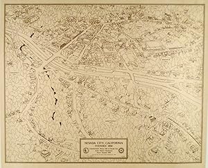
ORIGINAL SIGNED MAP OF NEVADA CITY, CALIFORNIA 1975. LINEN MOUNTED
Published by The Rotary Club of Nevada City, Nevada City, California, 1975
Seller: Hardy Books, Nevada City, CA, U.S.A.
Association Member: IOBA
Seller rating 5 out of 5 stars

First Edition Signed
Condition: Fine. First Edition. This is an ORIGINAL 1975 Map of Nevada City, California by Artist Robert Chrestensen. SIGNED by Artist Christensen. Linen Mounted. This is a three dimensional map, with principal buildings drawn to scale. This is #10 of 25 signed copies. Nevada City, California is the County seat of Nevada County California. At one time in the California Gold Rush, it was the third largest City in California, behind only San Francisco and Sacramento. It is in the heart of the California Northern Mines gold country. The image measures 21 1/2" x 27 1/4". The total piece, with white linen border, measures 26 1/4" x 30". Fine condition and certainly suitable for framing. Shipped rolled.
-

Map of a portion of the Sierra Nevada adjacent to the Yosemite Valley.
Publication Date: 1868
Seller: Geographicus Rare Antique Maps, Brooklyn, NY, U.S.A.
Association Member: ABAA ESA ILAB
Seller rating 4 out of 5 stars

Map First Edition Signed
1st Edition. Very good. Sporadic foxing and other imperfections, especially in the margins. Size 20.75 x 30 Inches. This is an 1868 edition of Charles Hoffmann and James Gardiner's detailed map of Yosemite Valley, California, and its surroundings, considered one of the earliest obtainable maps of that region. This map represents early government efforts under Frederick Law Olmsted and Josiah Dwight Whitney to map Yosemite as America's first reserved parkland. It offers superb detail, noting El Capitan, Cathedral Peak, Yosemite Fall(s), Half Dome, the Merced and San Joaquin Rivers, Lake Eleanor, a portion of Mono Lake, and much more. Surveying Yosemite The Yosemite Grant passed Congress on June 30, 1864, after which it was promptly signed into law by President Abraham Lincoln. This was the first instance of land being set aside expressly for preservation and public use by the U.S. federal government, which set a precedent for the 1872 creation of Yellowstone. The grant created an urgent need for a survey of the ceded lands before winter set in. Two young graduates from Yale's Scientific School, Clarence King and James Terry Gardiner, were assigned to the task. Through a government effort, Frederick Law Olmsted, famed designer of New York City's Central Park, paid for the King-Gardner survey. As the nation's premier park expert, Olmsted was harnessed by the Lincoln administration to draft a charter and plan for Yosemite. Eager to get some sort of map of the valley, Olmsted used personal finances to complete the survey before winter - with the expectation that the state would later reimburse him (they did). The initial survey was basic and offered only a loose sketch encompassing Yosemite Valley's shape and proportions. Little detail was included of the valley floor, but the cliffs were well mapped with hachure. In 1867, Charles F. Hoffman led a second survey expedition that included King and Gardiner to fully survey the valley floor. Publication History and Census The map was printed in New York by Julius Bien in 1868 for the first edition of Josiah Dwight Whitney's 1869 Geological Survey of California Yosemite Guide-Book . It exists in several states, which can be distinguished according to the inclusion, removal, or renaming of features. For example, 'Milk Ranch' and 'McLane's Pass' are renamed 'Mill Ranch' and 'Mono Pass,' respectively, in later states. This example does include Hite's Cove at the confluence of the Merced River and Devil's Gulch, though in a different location and without an adjoining road included in later states, suggesting that this is an early successor to the first state of the map (Rumsey 4212.019). The various states of this map are well represented in institutional collections (sometimes cataloged as 1867) but scarce to the market. It is closely related to a second map that accompanied the Yosemite Guide-Book by Gardiner and Clarence King (YosemiteValley-gardner-1870). References: OCLC 900664465. Signed by Author(s).