Map Oceania: First Edition (1 results)
 More images
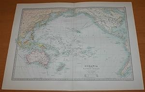
Published by Macmillan and Co., London 1890
- Softcover
- First Edition
Seller: Bailgate Books Ltd, Doncaster, United KingdomBailgate Books Ltd
Contact seller5-star sellerCondition: Used - Very good
US$ 41.22
US$ 19.09 shippingShips from United Kingdom to U.S.A.Quantity: 1 available
Softcover. Condition: Very Good. No Dust Jacket. First Edition. Single disbound coloured map sheet, from John Bartholomew's Library Reference Atlas. Map covers Oceania and the Pacific from China to America with Austrialasia and the Pacific Islands. Suitable for framing. Approx size 35 x 46cm, vertical centre fold. Occasional fai…nt marks in margin, map is otherwise clean, crisp and bright. Map includes: Australia, New Zealand, Hawaii or Sandwich Islands, Galapogos Islands, Polynesia, East Indain Archipelago, Melanesia, Fiji, Tonga, Papua or New Guinea, Philippines, Borneo, Sumatra, Java, Timor, Japan, Formosa (Taiwan), Yellow Sea, Okhotsk Sea, Berring Sea, Aleutian Islands, and parts of China, Alaska, Canada, USA and South and Central America. No dust jacket, as published. Quantity Available: 1. Shipped Weight: under 1 kg. Pictures of this item not already displayed here available upon request. Inventory No: 45021014023. All our books are sent by tracked mail.
