Order Total (1 Item Items):
Shipping Destination:

Map Peking, First Edition (6 results)
Skip to main search results
Search filters
Product Type
- All Product Types
- Books (4)
- Magazines & Periodicals (No further results match this refinement)
- Comics (No further results match this refinement)
- Sheet Music (No further results match this refinement)
- Art, Prints & Posters (No further results match this refinement)
- Photographs (No further results match this refinement)
- Maps (2)
- Manuscripts & Paper Collectibles (No further results match this refinement)
Condition Learn more
- New (No further results match this refinement)
- As New, Fine or Near Fine (No further results match this refinement)
- Very Good or Good (2)
- Fair or Poor (No further results match this refinement)
- As Described (4)
Binding
Collectible Attributes
- First Edition (6)
- Signed (No further results match this refinement)
- Dust Jacket (No further results match this refinement)
- Seller-Supplied Images (4)
- Not Print on Demand (6)
Language (1)
Free Shipping
- Free Shipping to U.S.A. (No further results match this refinement)
Seller Location
Seller Rating
-
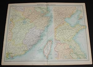
Map of Eastern China from the 1920 Times Survey Atlas (Plate 64) including Hankow, Anking, Nanking, Hangchow, Shanghai, Ningpo, Foochow, Canton, Hong Kong, Peking, Tientsin, Tsinan, Amoy and Taiwan (Formosa)
Published by The Times, London, 1920
Map First Edition
US$ 22.04
US$ 19.39 shipping
Ships from United Kingdom to U.S.A.Quantity: 1 available
Add to basketSoftcover. Condition: Very Good. Dust Jacket Condition: No Dust Jacket. First Edition. Disbound single sheet with vertical centre fold from the 1920 "The Times Survey Atlas of the World". Map is in colour and suitable for framing. Province boundaries are marked in different colours with colour infill in matching paler colours, seas are coloured blue. Map at scale 1:3,000,000 and split over two continuation panels. Map covers Kiangsi, Anhwei, Shantung, Fukien, Kwangtung, Chekiang, Chinli, Kiangsu, Hankow, Anking, Nanking, Hangchow, Shanghai, Ningpo, Foochow, Canton, Hong Kong, Peking, Tientsin, Tsinan, Amoy, Taiwan (Formosa), Gulf of Pechihli, Gulf og Liaotung, etc. Slightly darkened edges with occasional light foxing in margins, sheet is otherwise clean and crisp. Item Type: Map. Single sheet map/chart which is suitable for framing and will be shipped rolled and in a cardboard tube. Quantity Available: 1. Shipped Weight: under 1 kg. Pictures of this item not already displayed here available upon request. Inventory No: 45020034043. All our books are sent by tracked mail.
-

China and the nations; being the draft of the report on international problems prepared for the International problems committee of the Peoples conference of delegates at Peking in April, 1925, by Wong Ching-Wai, rendered in English, and edited with an introduction, explanatory footnotes and a map, by I-Sen Teng and John Nind Smith
Published by New York: Stokes, 1927
First Edition
Hardcover. Condition: Very Good. No Jacket. 1st Edition. FIRST AMERICAN EDITION; 1stUSedn printed from the British Edition sheets.; 8vo Blue cloth, 14 x 22cm, This is a very nice copy, in original blue cloth, with the white KMT symbol on the cover. There is some discoloration to the spine, a darkening of the cloth, a bit of head/tail spine wear, else a clean, solid copy., H.S. Quigley's signed copy, Ow VG/ndj: 137pp, index, map. WONG CHING-WAI or WANG CHING-WEI [aka. WANG JINGWEI] . Although the title page spells the author's name as: "WONG Ching-wai" this was a common transliteration of Chinese names at that time. WorldCat also names him as: Zhaoming Wang. Wang Ching-Wei [1883-1944] was born as Wang Zhaoming [Wang Chao-ming]. He was widely known by his 'pen name' "Jingwei," as a Chinese politician, at first and ally, only later to turn against Sun Yat-sen, the KMT party and become a despised traitor and Japanese Government sympathizer during second Sino-Japanese war 1937-1945. He has been hated and the subject of shame to the Chinese both Nationalists and Communists. Wang was initially a member of the left wing of the Kuomintang [KMT] party, but later became increasingly anti-communist after his efforts to collaborate with the Chinese Communist Party [CCP] ended in political failure. His political orientation veered sharply to the right later in his career. Wang was a close associate of Sun Yat-sen during the last twenty years of Sun's life. After Sun's death, Wang engaged in a political struggle with Chiang Kai-shek for control over the Kuomintang Party, but he lost. Wang remained inside the Kuomintang, but continued to have disagreements with Chiang until the outbreak of the Second Sino-Japanese War in 1937. After which he accepted a controversial invitation to form a "Japanese-supported" collaborationist government in Nanjing. Wang served as the head of that Chinese state for the Japanese until he died, shortly before the end of World War II. Although he is still regarded as an important contributor in the Xinhai Revolution, the typical narratives often regard him as a traitor in the "War of Resistance." CONTENTS: Per the preface: "The essays express the official statements and permanent opinion of China's National Party and of the mass of Chinese, as voiced by Wang Ching-wei." [summarized] . Wang outlines the "Will of the President of the Kuomintang." His "Prefatory Letter, addressed to the preliminary Conference." His essays continue to define the "Definition of Imperialism, The Influence of Imperialism on World Politics." He continues with case examples of: "The Influence of Imperialism in China: Introductory Survey: First Period: From the Opium War to the Sino-Japanese War 1890-1894. Second Period: From the Sino-Japanese War to the Boxer Rising 1895-1900. Third Period: From the Boxer Rising to the Beginning of the Great European War 1900-1914. Fourth Period: From the Beginning of the Great European War to the Washington Conference 1914-1921. Fifth Period: From the Washington Conference up to the present." [Present means 1927, publication date of this book, considered to be the first year of the Communist Revolution in China] "The Chinese People's Revolution Against Imperialism. Resolutions Concerning International Problems, Drafted for the People's Conference." With a folding map of China, based on that prepared by Dr. Sun Yat-sen, showing government controlled railways, bibliography. ASSN: QUIGLEY, Harold S., author of: 1932, Japanese Government an.
-
Three Years Travels from Moscow Over-Land to China: thro' Great Ustiga, Siriania, Permia, Sibiria, Daour, Great Tartary, &c. to Peking. Containing, An exact and particular Description of the Extent and Limits of those Countries, and the Customs of the Barbarous Inhabitants; with reference to their Religion, Government, Marriages, daily Imployments, Habits, Habitations, Diet, Death, Funerals, &c. Written by his Excellency E. Ysbrants Ides, Ambassador from the Czar of Muscovy to the Emperor of China. Illustrated with a large Map of the Countries, drawn by the Ambassador upon his Journey, and many curious Cuts. To which is annex'd an accurate description of China, done originally by a Chinese Author: With several Remarks, by way of Commentary, alluding to what our European Authors have writ of that Country. Printed in Dutch by the Direction of Burgomaster Witzen, formerly Ambassador in England; and now faithfully done into English
Published by Printed for W. Freeman, J. Walthoe, T. Newborough, J. Nicholson, and R. Parker, London, 1706
Seller: Heritage Book Shop, ABAA, Beverly Hills, CA, U.S.A.
Seller rating 5 out of 5 stars

First Edition
First Edition. Full Description: IDES, Evert Ysbrants. Three Years Travels from Moscow Over-Land to China. London: Printed for W. Freeman, J. Walthoe, T. Newborough, J. Nicholson, and R. Parker, 1706. First English edition. Small quarto (9 9/16 x 7 1/2 inches; 244 x 190 mm)). [12], 191, 190-210 pp. Complete with an engraved alegorical additonal title-page (dated 1705), a large folding map and 30 engraved plates, eight of which are folding. Contemporary paneled calf, rebacked to style. Spine with red morocco spine label. Top edge dyed brown, others speckled red. Some general light foxing and toning. Overall a very good copy. "In 1692, Evert Ysbrants Ides was asked by Tsar Peter to serve as ambassador to the Emperor of China. Before his return to Moscow in 1695, he passed through many countries and regions, including Perm, Siberia, and 'Great Tartary' (West Asia)." (NYPL). "Tsar Peter Alekseevich invested resources in maintaining his relationship with China, dispatching an embassy in 1692. He appointed a foreign diplomat, Eberhard Isbrand Ides, to act as his ambassador and Adam Brand from Lubeck as the embassy's secretary.18 The embassy itself included more than 250 men, including nobles and merchants, both to negotiate new terms following Nerchinsk but also to investigate the market in Beijing, 'where Silk, Cloath, Gold and Silver, Jewels and all sorts of fine Manufactures, were sold.' Ides also toured 'the Emperor's Dispensary, which I was willing to make some Scrutiny into, it being full stock'd with all sorts of Roots, Herbs, and Med'cines. . Next to this was a Toy-shop, which I enter'd, and bought what I like.'" (Oxford Research Encyclopedia). "Defoe's novel [The Farther Adventures of Robinson Crusoe] paints an impressive picture of Russia. The writer himself had never been to this part of the world, and he based the protagonist's adventures on the true tales of travelers. Izbran Ides and Adam Brand, who had traveled from Moscow to Peking." (Robinson Crusoe and Daniel Defoe's guide to Siberia. Ekaterina Aleeva). ESTC T55175 HBS 69427. $4,000.
-

From Peking to Mandalay: A Journey from North China to Burma through Tibetan Ssuch'uan and Yunnan. With map and illustrations.
Published by John Murray,, London,, 1908
Seller: Llibreria Antiqu�ria Delstres, Canet de Mar, B, Spain
Seller rating 4 out of 5 stars

First Edition
First edition. Primera edici�n. Sir Reginald Fleming Johnston, (13 de octubre de 1874 - 6 de marzo de 1938) fue un diplom�tico y funcionario colonial escoc�s que ejerci� de tutor y consejero de Puyi, el �ltimo emperador de China. Tambi�n fue el �ltimo comisario brit�nico de Weihaiwei. El libro de Johnston Crep�sculo en la Ciudad Prohibida (1934) se utiliz� como fuente para la dramatizaci�n cinematogr�fica de Bernardo Bertolucci sobre la vida de Puyi, El �ltimo emperador. Un "anticristiano militante", Johnston estaba fascinado por el budismo chino. En 1908, tuvo una audiencia privada con el 13� Dalai Lama, uno de los pocos occidentales en hacerlo. Durante su servicio escribi� tres libros: De Pek�n a Mandalay (1908), Le�n y drag�n en el norte de China (1910) y China budista (1913). Frontis, XII p�ginas, 460 p�ginas. Ilustrado con 33 l�minas fotogr�ficas de personajes, vistas, costumbres, etc. fuera de texto, y un mapa desplegable: "Map in illustration of the Author's Itinerary from Hankow to Bhamo", "Sketch Map of the Author's Routes in the Far East", restaurado, con perdidas de papel que afectan a un pliego del mapa. Encuadernaci�n de la �poca en tela verde con el titulo dorado en el plano y lomo, ligeramente rozada en los planos. Ex libris de anteriores propietarios pegados en las hojas de guarda. Buen estado en general. 22,5x14,5 cm.
-
Tourist Map of Peking
Published by no publisher (Beijing) 1972, 1972
Seller: Andrew Barnes Books / Military Melbourne, Melbourne, VIC, Australia
Seller rating 4 out of 5 stars
First Edition
1st ed. thus card folder As New small octavo , Broadside, 50 x 73 cms. folding to 17 x 12 cms. A total of ten colour maps. One side has 4 maps, inc. one that occupies half of the sheet; the other 8 maps. Largest map is 'Transport routes in Peking's Municipal Area.' Smaller maps 'Administrative Divisions, Bus Routes in Peking suburbs, Long-Distance Bus Routes', as well as plans of the Summer Palace, Palace Museum & Peihai. Map is mint & is presented in a slightly chipped decorated card folder. Very scarce, especially in this condition.
-

Map of Hong Kong and the Territory Leased to Great Britain under the Convention Between Great Britain and China Signed at Peking on the 9th of June 1898.
Publication Date: 1922
Seller: Geographicus Rare Antique Maps, Brooklyn, NY, U.S.A.
Association Member: ABAA ESA ILAB
Seller rating 4 out of 5 stars
Map First Edition
1st Edition. Very good. Dissected and mounted on linen in 32 panels. Soiling. Paste down map reading instructions adhered to third panel from top in far right column. Size 29.625 x 38.25 Inches. This is a 1922 British War Office map of Hong Kong and the New Territories. It was issued in March of 1922, shortly following the historic Hong Kong Seaman's Strike. A Closer Look Coverage embraces Hong Kong from Tai-shan Bay to Mirs Point and from China to Po Toi (Pu Toi). Cities, towns, and villages are labeled throughout the Crown Colony, including Victoria and Kowloon. In Victoria, Murray Barracks, the hospital, the sugar refinery, and the Tai-ku Sugar Factory are identified. Roads are illustrated, and topography is illustrated using contours. Manuscript notations mark police stations in the New Territories and several newly constructed roads. Bays, channels, and other coastal locations are also noted. The entire chart is overlaid by a grid meant to make finding a specific location easier. Instructions on how to use this grid are included via a pastedown along the right border. Hong Kong Seamen's Strike of 1922 In January 1922, the Seaman's Strike disrupted commerce in the region. At the time, there was an extraordinary gap between the wages paid to Chinese and British seamen. Seeking more equitable treatment, over 30,000 Chinese seamen from Hong Kong and Canton (Guangzhou) declared a strike. The strike lasted 52 days. By February, over $5 million in cargo was floundering in Hong Kong Harbor and shipping companies began bypassing the island. By early March, the city was near anarchy, with food rationed, trash piling up, businesses closed, and public transportation halted. On March 5, the shipping companies eventually backed down and agreed to a 15-30% wage increase. Publication History and Census This map was created by the Geographical Section of the General Staff of the British War Office. The first edition was published in 1905, and the current example was published in 1922. We note four examples in institutional collections at the British Library, the University of Kansas, the University of British Columbia, and the National Library of Scotland. We are aware of only one other instance when this chart entered the private market. References: OCLC 779582655.