Order Total (1 Item Items):
Shipping Destination:

Map Poland, First Edition (21 results)
Skip to main search results
Search filters
Product Type
- All Product Types
- Books (10)
- Magazines & Periodicals (No further results match this refinement)
- Comics (No further results match this refinement)
- Sheet Music (No further results match this refinement)
- Art, Prints & Posters (4)
- Photographs (No further results match this refinement)
- Maps (7)
- Manuscripts & Paper Collectibles (No further results match this refinement)
Condition Learn more
- New (No further results match this refinement)
- As New, Fine or Near Fine (3)
- Very Good or Good (7)
- Fair or Poor (No further results match this refinement)
- As Described (11)
Binding
Collectible Attributes
- First Edition (21)
- Signed (No further results match this refinement)
- Dust Jacket (1)
- Seller-Supplied Images (16)
- Not Print on Demand (21)
Language (2)
Free Shipping
Seller Location
Seller Rating
-

National Geographic Magazine September, 1958 with Poland and Czecholsovakia map supplement.
Published by National Geographic, 1958
First Edition
Magazine. Condition: Good. First Edition. this Magazine is in Good+ condition. overall, magazine is clean, tight and bright. Map Supplement is in Fine condition in magazine.
-
The Face and Faith of POLAND (Folded color-illustrated essay & map)
Published by National Geographic Soc April 1982, Washington DC, 1982
First Edition
Folded essay/map. Condition: Fine unmarked. 1st edition. Cold War era map(s) of Poland with color photos illustrating essays about Poland's history, culture, people, religion. Orig published as supplement to National Geo magazine. Rare item. Folded size 5-3/4 x 9-1/2, unfolded 36-1/2 x 22-1/2, color photos & illustrations.
-

National Geographic Map Of Poland And Czechoslovakia Sept 1958
Published by National Geographic, United States, 1958
Map First Edition
soft. Condition: See Pic.
-

National Geographic Map Of Poland And Czechoslovakia Sept 1958
Published by National Geographic, United States, 1958
Map First Edition
soft. Condition: See Pic.
-

National Geographic Map Of Poland And Czechoslovakia Sept 1958
Published by National Geographic, United States, 1958
Map First Edition
soft. Condition: See Pic.
-
![Seller image for Poland of Today. [With illustrations and a map.] for sale by MW Books](https://pictures.abebooks.com/inventory/md/md30992838005.jpg)
Poland of Today. [With illustrations and a map.]
Published by [Warsaw] : 'Polonia' Foreign Languages Publishing House, 1954
First Edition
1st edition. Good copy in the original stiff-card wrappers; edges somewhat nicked and dust-dulled as with age. Remains quite well-preserved overall. Physical description: 144 p.: ill, fold. col. map; 21 cm.Subjects: Poland Description and travel.Poland Politics and government. Poland Economic conditions.Poland Description and travel. Genre: Illustrated. 3 Kg.
-
![Seller image for Poland of Today. [With illustrations and a map.] for sale by MW Books Ltd.](https://pictures.abebooks.com/inventory/md/md30996332317.jpg)
Poland of Today. [With illustrations and a map.]
Published by [Warsaw] : 'Polonia' Foreign Languages Publishing House, 1954
First Edition
1st edition. Good copy in the original stiff-card wrappers; edges somewhat nicked and dust-dulled as with age. Remains quite well-preserved overall. Physical description: 144 p.: ill, fold. col. map; 21 cm.Subjects: Poland Description and travel.Poland Politics and government. Poland Economic conditions.Poland Description and travel. Genre: Illustrated. 1 Kg.
-
Map Collectors' Circle Series, Fourth Year (Volume IV), No. 31 : The Malinowski Collection of Maps of Poland, Part II
Published by Map Collectors' Circle, London, 1966
First Edition
Paperback. Condition: Very Good+ condition. First Edition. London: Map Collectors' Circle, 1966. Very Good+ condition. Clean and unmarked. NOT a library discard. NO owner's name or bookplate. Part 2, describing the Malinowski Collection of Maps of Poland. A continuation from Map Collectors' Circle, No. 25. Describes entries #169-313. Illustrated with 12 plates. Bound in the original tan wraps, printed in black. 7.25" wide by 9.75" tall. First Edition. Softcover. Very Good+ condition. 58pp. Great Packaging, Fast Shipping.
-
UKRAINE, POLAND AND RUSSIA AND THE RIGHT OF THE FREE DISPOSITION OF PEOPLES. WITH ONE MAP.
Published by Washington DC: Friends of Ukraine, 1919
Seller: Steve Finer - Rare Books, Greenfield, MA, U.S.A.
Association Member: SNEAB
Seller rating 4 out of 5 stars

First Edition
Soft cover. Condition: Very Good. No Jacket. 1st Edition. 8vo, printed wrappers, 16pp. A Very Good copy.
-
Map Collectors' Circle Series, Third Year (Volume III), No. 25 : The Malinowski Collection of Maps of Poland, Part I
Published by Map Collectors' Circle, London, 1965
First Edition
Paperback. Condition: Very Good condition. First Edition. London: Map Collectors' Circle, 1965. Very Good condition. Clean and unmarked. NOT a library discard. NO owner's name or bookplate. Describes 168 maps, many with commentary. Illustrated with 12 plates. Bound in the original tan wraps, printed in black. 7.25" wide by 9.75" tall. First Edition. Softcover. Very Good condition. 58pp. Great Packaging, Fast Shipping.
-
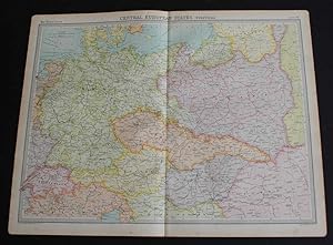
Map of "Central European States" from 1920 Times Atlas (Plate 38) including Germany, Switzerland, Austria, Czheco-Slovakia, Hungary and Poland with parts of Lithuania, Yugo-Slavia, Italy, Denmark and Rumania
Published by The Times, London, 1920
First Edition
US$ 26.11
US$ 19.14 shipping
Ships from United Kingdom to U.S.A.Quantity: 1 available
Add to basketSoftcover. Condition: Very Good. Dust Jacket Condition: No Dust Jacket. First Edition. Disbound single sheet with vertical centre fold from the 1920 "The Times Survey Atlas of the World". Map is in colour and suitable for framing. Colour is according to country with slightly darker shades marking the borders and matching pastel shade infills. Map at scale 1:3,000,000. Map covers Germany, Switzerland, Austria, Czheco-Slovakia, Hungary and Poland with parts of Lithuania, Yugo-Slavia, Italy, Denmark and Rumania and covers modern day Liechtenstein, Slovenia, Czech Republic and Slovakia Slightly darkened edges with some occasional light foxing in the margins and at the centre fold. Sheet is otherwise crisp, clean and bright. Size: 46 x 58cm approx. Quantity Available: 1. Shipped Weight: under 1 kg. Pictures of this item not already displayed here available upon request. Inventory No: 45020044015. All our books are sent by tracked mail.
-
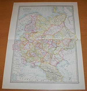
Map of 'Russia in Europe' - Sheet 40 disbound from the 1890 'The Library Reference Atlas of the World' including Finland, Lapland and Poland and modern day Ukraine, Belarus, Latvia, Lithuania, Estonia,Georgia and Azebaijan
Published by Macmillan and Co., London, 1890
First Edition
US$ 39.16
US$ 19.14 shipping
Ships from United Kingdom to U.S.A.Quantity: 1 available
Add to basketSoftcover. Condition: Very Good. Dust Jacket Condition: No Dust Jacket. First Edition. Single disbound coloured map sheet, from John Bartholomew's Library Reference Atlas. Suitable for framing. Approx size 46 x 35cm, horizontal centre fold. Faint smudges in margin, map is clean, crisp and bright. Sheet covers what was known as 'Russia in Europe' and extends as far east as the Ural Mountains. The mapped area covers what is now Ukraine, Belarus, Latvia, Lithuania, Estonia,Georgia, Azebaijan and part of Russia. Also included are Finland and parts of Norway and Sweden, part of modern Poland, the Black Sea, Constantinople (Istambul), Sea of Azof, Caspian Sea (part), Kara Sea (part), Gulf of Bothnia, Whie Sea, etc. No dust jacket, as published. Quantity Available: 1. Shipped Weight: under 1 kg. Pictures of this item not already displayed here available upon request. Inventory No: 45021014020. All our books are sent by tracked mail.
-

All About Poland: Facts, Figures and Documents. With map.
Published by London: Minerva Publishing Co., 1941
First Edition
Hardcover. Condition: Very Good. Dust Jacket Condition: Good. 1st Edition. 292 pages. Scarce, especially with dust jacket. Includes large fold-out map in pocket. Map of Germany and Poland. Map issued by John Bartholomew in September 1939. Highly detailed. Gift inscription on free front-endpaer, in Polsih.
-

"Prussia." - Polska Poland Polen Litauen Lithuania Ostpreußen Westpreußen Preußen map Karte carte
Language: Latin
Published by Amsterdam, J. Hondius, 1618
Seller: Antiquariat Steffen Völkel GmbH, Seubersdorf, Germany
Seller rating 5 out of 5 stars

Map First Edition
Kupferstich-Karte aus der ersten französischen Ausgabe von Bertius' "Atlas Minor" gedruckt in Amsterdam bei J. Hondius im Jahre 1618. Mit französischem Text auf der Rückseite. -- Maße: ca. 9,5 x 13,5 cm. -- rechts mit winzigem Wurmlöchlein, sonst gut erhalten. || Copper engraved map out of the first French edition of Bertius' "Atlas Minor", published by J. Hondius in Amsterdam in 1618. With French text on verso. -- with tiny wormhole on the right, otherwise in good condition. // Wir, das Antiquariat Steffen Völkel, kaufen und verkaufen alte Bücher, Handschriften, Zeichnungen, Autographen, Grafiken und Fotografien. Wir sind stets am Ankauf von kompletten Bibliotheken, Sammlungen und Nachlässen interessiert. la Gewicht in Gramm: 10.
-

Map - Poland
Published by [1805], London, 1805
Seller: Renaissance Books, ANZAAB / ILAB, Dunedin, New Zealand
Association Member: ANZAAB ILAB
Seller rating 5 out of 5 stars
Map First Edition
Map. Condition: Good. Dust Jacket Condition: No Dust Jacket. First Edition. Moderate foxing. Two fold lines.; Map titled "A Map of Poland from the best Authorities 1805". Dimensions: 255 x 210mm. This map is from William Guthrie's "A New Geographical, Historical, and Commercial Grammar and Present State of the Several Kingdoms of the World", eighteenth edition, Montrose: Printed by D. Buchanan, 1805. ; Map.
-

Map of German Empire including today's Poland, Germany, Switzerland, Austria, Holland, Belgium and Luxembourg (Nouvelle Carte des Cercles de L'Empire Avec des Tables des Divers Souverains, Qui Composent ses Dietes et ses Differents Colleges)
Published by Amsterdam, 1718
Seller: Trillium Antique Prints & Rare Books, Franklin, TN, U.S.A.
Seller rating 3 out of 5 stars

Art / Print / Poster First Edition
Condition: Fine. 1st Edition. This originally hand-colored engraving is from Henri Abraham Chatelain's Atlas Historique. The work was published by the author in Amsterdam between 1718 and 1720.The text was compiled by Gueudeville & Garillon. The maps were completed by Chatelain with some influenced by Guillaume de l'Isle's work.The work was published in several editions with the second edition the first to include additional maps not found in the first including a map of the world, Americas, Europe, Asia, and Africa. These engravings come from mixed editions. Those from volumes 5 to 7 are first edition. The engravings from volumes 1 to 4 are from early ediitons.Atlas Historique was a highly ambitious and groundbreaking work covering genealogy, cosmography, topography, heraldry, and chronology. It was intended for the general public and the increased fascination with the recently conquered colonies and the new discoveries. Chatelain's maps are an outstanding example of the golden age of French mapmaking. --- The work is in good to excellent condition overall. There can be occasional offset, toning, or some separation to fold out plates. There may be a few minor imperfections or faint marks to be expected with age. Please review the image carefully for condition and contact us with any questions. --- Paper Size ~ 25 3/4" by 21 1/2" (Fold Out).
-
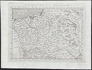
Map of Poland
Published by Venice, 1596
Seller: Trillium Antique Prints & Rare Books, Franklin, TN, U.S.A.
Seller rating 3 out of 5 stars
Art / Print / Poster First Edition
Condition: Fine. 1st Edition. This early map engraving is from Claudius Ptolemaeus (Ptolemy) and Giovanni Antonio Magini's "Geographiae universae tum veteris, tum novae absolutissimum opus, duobus voluminibus distinctum". The work was published in Venice by S. Galignani de Karera's Heirs in 1596. This is the first Magini edition. "The copperplate maps prepared for this edition, and engraved by Girolamo Porro, are on a smaller scale, and somewhat better executed than those in the editions of 1562." (Phillips) --- This work is considered a later published ediiton of Ptolemy (Ptolemaeus)âs Geographia. The work was considered one of the most influential cartographic accounts of the ancient world and served as inspiration for all Renaissance mapmakers. He compiled what was known of the world's geography in the Roman Empire during his time (circa 90-168 AD). Ptolemy was a mathematician, astronomer, geographer, astrologer, and poet. The earliest known manuscripts of Geographia date to 1300 and was first printed in 1477. --- The work is in very good to excellent condition overall. There may be a few minor marks, faint text bleed through, or imperfections to be expected with age. Please review the image carefully for condition and contact us with any questions. --- Paper Size ~ 8 1/4" by 6 1/4".
-

Map of Poland
Published by Venice, 1596
Seller: Trillium Antique Prints & Rare Books, Franklin, TN, U.S.A.
Seller rating 3 out of 5 stars
Art / Print / Poster First Edition
Condition: Fine. This engraved map is from Claudius Ptolemaeus (Ptolemy) and Giovanni Antonio Magini's Geographiae universae tum vet(eris, t)um novae absolutissimum opus, duobus voluminibus distinct(um). Auctore I. A. Magino. The work was published in 1596 in Venice by S. Galignani Erben. This is the first Magini edition in Latin. The maps were engraved by Girolamo Porro.This work is considered a later published editon of Ptolemy (Ptolemaeus)âs Geographia. The work was considered one of the most influential cartographic accounts of the ancient world and served as inspiration for all Renaissance mapmakers. He compiled what was known of the world's geography in the Roman Empire during his time (circa 90-168 AD). Ptolemy was a mathematician, astronomer, geographer, astrologer, and poet. The earliest known manuscripts of Geographia date to 1300 and was first printed in 1477. --- The work is in very good to excellent condition overall. There is text to verso which may have some bleed through. There may be a few minor imperfections or faint marks to be expected with age. Please review the image carefully for condition and contact us with any questions. --- Paper Size ~ 8 3/4" by 6 1/4".
-
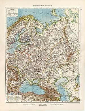
Map : 'Europaisches Russland'. (Map of European Russia.) Colour lithograph on a vellin type paper. Description: This large antique map is taken from; 'Andrees Allgemeiner Handatlas in 126 Haupt-Und 139 Nebenkarten', Bielefeld; Leipzig: Velhagen & Klasing 1899. Andrees Allgemeiner Handatlas was a major cartographic work published in several German and foreign editions 1881-1937. It was named after Richard Andree (1835-1912) and published by Velhagen & Klasing, Bielefeld and Leipzig, Germany. By using chromolithography, rather than copper plate engraving, but reproducing the maps from zinc plates that were etched in relief (just like letterpress printing), V & K was able to offer detailed maps at a much lower price than competing works, such as the 7th and 8th editions of Stielers Handatlas.Artists and Engravers: Richard Andree (1835 - 1912) was, like his father Karl Andree, a German geographer noted for devoting himself especially to ethnography. His main work, however, is his Allgemeiner Handatlas (Leipzig, first edition 1881, final edition 1937), one of the most comprehensive world atlases of all times. The early editions of the Times Atlas of the World (1895-1900) are based on this atlas, as was Cassell's Universal Atlas. Condition: Very good, given age. Middle fold, as issued. Left edge with small closed tears (backed with acid-free archival tape) and creases. Storage location: B37-09 The overall size is ca. 17.3 x 22 inch. The image size is ca. 14.6 x 18.9 inch. The overall size is ca. 44 x 56 cm. The image size is ca. 37 x 48 cm.
-

"Magni Ducatus Lithuaniae, caeterarumque regionum illi adiacentium exacta descriptio" - Lithuania Poland Litauen Polen Polska Ukraine / Karte map
Language: Latin
Published by Amsterdam, Janssonius, 1613
Seller: Antiquariat Steffen Völkel GmbH, Seubersdorf, Germany
Seller rating 5 out of 5 stars
Map First Edition
Erste Ausgabe / First edition. Original altkolorierte Kupferstich-Karte. -- Blatt-Maße: ca. 82 x 80 cm. -- etwas gebräunt, mit alten Faltspuren, mit fachmännisch restauriertem Einriss, sonst gut erhalten. || Original old colored engraved map. // // The Radziwill Map is the first cartographic source to use the name "Ukraine". The first edition of the map was made by Willem Blaeu in 1613. Important wall map of Lithuania and Poland, with parts of Russia, Ukraine and Latvia, extending as far as Cracow, Kiev, Warsaw, Riga, Konigsberg and Dantzig. The map was commissioned by Prince Nicolas Christophe Radziwill. The map remained the main source of geographical knowledge about the region for the next 150 years. The map contains a huge number of names of cities, villages, rivers, lakes, and territories of Ukraine. -- somewhat browned, with old folds, with a restored tear, otherwise in good condition. // Wir, das Antiquariat Steffen Völkel, kaufen und verkaufen alte Bücher, Handschriften, Zeichnungen, Autographen, Grafiken und Fotografien. Wir sind stets am Ankauf von kompletten Bibliotheken, Sammlungen und Nachlässen interessiert. la Gewicht in Gramm: 50.
-

Antique Map-POLAND-KINGDOM-Schneider-Bruyset-1785
Publication Date: 1785
Seller: Pictura Prints, Art & Books, Overasselt, Netherlands
Seller rating 5 out of 5 stars
Art / Print / Poster First Edition
Original hand-coloured engraving on a verge type handlaid paper. on paper. Size in cm: The overall size is ca. 19 x 15.5 cm. The image size is ca. 12 x 9.5 cm. Size in inch: The overall size is ca. 7.5 x 6.1 inch. The image size is ca. 4.7 x 3.7 inch.Map, number XVII, titled: 'Du Royaume de Pologne.' It shows: a map of the Kingdom Poland. Corresponding text included. This map originates from "Atlas des Enfans, ou Nouvelle Methode pour apprendre la Geographie, avec un Nouveau Traite de la Sphere", published in 1785 in Lyon by Bruyset. Although no author is given on the title page, J.H. Schneider is generally accepted as the author of this work. The first edition was published in 1760. The text, supplied with the corresponding map, explains the (otherwise unmarked) maps in the form of questions and answers, a well-known form for teaching books of the period.Artists and Engravers: Author: J.H. Schneider. Publisher: Jean-Marie Bruyset. Artist and engraver unknown.Condition: Very good, given age. Folds, as issued. Mild foxing in the left and bottom margins.General age-related toning and/or occasional light soiling from handling. Please study scan carefully.Keywords: ANTIQUE MAP-POLAND-KINGDOM-SCHNEIDER-BRUYSET(PCO) C252-16.