Map Spain by Walker: First Edition (4 results)
 More images
Published by Edward Stanford, London 1857
- Softcover
- First Edition
Seller: Bailgate Books Ltd, Doncaster, , United KingdomBailgate Books Ltd
Contact seller5-star sellerCondition: Used - Good
US$ 26.17
US$ 19.19 shippingShips from United Kingdom to U.S.A.Quantity: 1 available
Softcover. Condition: Good. No Dust Jacket. First Edition. Disbound single Sheet Map with vertical centre fold from "The University Atlas of Classical and Modern Geography, including all the Recent Geographical Discoveries". Sheet is a little foxed and marked with darkened edges. Some wear and minor damage to edges and corners.…Fold is slightly split at both ends and a little fragile. Map covers the whole of mainland Spain and Portugal and includes the Balearic Islands (Iviza, Mallorca and Menorca), the Pyrenees, the Strait of Gibraltar and the Gulf of Lyon. Regions are differentiated with coloured lines. Quantity Available: 1. Shipped Weight: under 1 kg. Pictures of this item not already displayed here available upon request. Inventory No: 45019044029. All our books are sent by tracked mail.
 More images
Published by London : Published by the Society, and Chapman and Hall, 1844. 1844
- First Edition
- Map
Seller: Schilb Antiquarian, Columbia, MO, U.S.A.Schilb Antiquarian
Contact seller5-star sellerCondition: Used - Near fine
US$ 99.00
Free ShippingShips within U.S.A.Quantity: 1 available
No Binding. Condition: Near Fine. 1st Edition. 1844 BEAUTIFUL Huge Color MAP of Northeast Spain Madrid Hispania Iberia ATLAS From "Society for Diffusion of Useful Knowledge" A beautifully hand-colored map from the 1844 printing of "Society for the Diffusion of Useful Knowledge" The Society for the Diffusion of Useful Knowledge (…SDUK), founded in 1826, and wound up in 1848, was a Whiggish London organisation that published inexpensive texts intended to adapt scientific and similarly high-minded material for the rapidly expanding reading public. It was established mainly at the instigation of Lord Brougham with the objects of publishing information to people who were unable to obtain formal teaching, or who preferred self-education. Engraver: J & C Walker Atlas title: Maps of the Society for the Diffusion of Useful Knowledge. Map title: Spain II, Northeast, Madrid to Mediterranean Published: London : Published by the Society, and Chapman and Hall, 1844. Language: English Notes & contents: Originally from the David Rumsey Collection FREE SHIPPING WORLDWIDE Wear: wear as seen in photos Publisher: London : Published by the Society, and Chapman and Hall, 1844. Size: ~13.5in X 16in (33cm x 41cm).
 More images
Published by London : Published by the Society, and Chapman and Hall, 1844. 1844
- First Edition
- Map
Seller: Schilb Antiquarian, Columbia, MO, U.S.A.Schilb Antiquarian
Contact seller5-star sellerCondition: Used - Near fine
US$ 99.00
Free ShippingShips within U.S.A.Quantity: 1 available
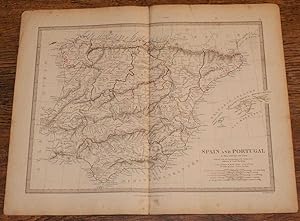
No Binding. Condition: Near Fine. 1st Edition. 1844 BEAUTIFUL Huge Color MAP of Modern Spain & Portugal Hispania Iberia ATLAS From "Society for Diffusion of Useful Knowledge" A beautifully hand-colored map from the 1844 printing of "Society for the Diffusion of Useful Knowledge" The Society for the Diffusion of Useful Knowledge…(SDUK), founded in 1826, and wound up in 1848, was a Whiggish London organisation that published inexpensive texts intended to adapt scientific and similarly high-minded material for the rapidly expanding reading public. It was established mainly at the instigation of Lord Brougham with the objects of publishing information to people who were unable to obtain formal teaching, or who preferred self-education. Engraver: J & C Walker Atlas title: Maps of the Society for the Diffusion of Useful Knowledge. Map title: Spain and Portugal, Modern Published: London : Published by the Society, and Chapman and Hall, 1844. Language: English Notes & contents: Originally from the David Rumsey Collection FREE SHIPPING WORLDWIDE Wear: wear as seen in photos Publisher: London : Published by the Society, and Chapman and Hall, 1844. Size: ~13.5in X 16in (33cm x 41cm).
 More images
Published by London : Published by the Society, and Chapman and Hall, 1844. 1844
- First Edition
- Map
Seller: Schilb Antiquarian, Columbia, MO, U.S.A.Schilb Antiquarian
Contact seller5-star sellerCondition: Used - Near fine
US$ 99.00
Free ShippingShips within U.S.A.Quantity: 1 available
No Binding. Condition: Near Fine. 1st Edition. 1844 BEAUTIFUL Huge Color MAP of Ancient Spain & Portugal Hispania Iberia ATLAS From "Society for Diffusion of Useful Knowledge" A beautifully hand-colored map from the 1844 printing of "Society for the Diffusion of Useful Knowledge" The Society for the Diffusion of Useful Knowledge… (SDUK), founded in 1826, and wound up in 1848, was a Whiggish London organisation that published inexpensive texts intended to adapt scientific and similarly high-minded material for the rapidly expanding reading public. It was established mainly at the instigation of Lord Brougham with the objects of publishing information to people who were unable to obtain formal teaching, or who preferred self-education. Engraver: J & C Walker Atlas title: Maps of the Society for the Diffusion of Useful Knowledge. Map title: Ancient Spain & Portugal Hispania or Iberia Published: London : Published by the Society, and Chapman and Hall, 1844. Language: English Notes & contents: Originally from the David Rumsey Collection FREE SHIPPING WORLDWIDE Wear: wear as seen in photos Publisher: London : Published by the Society, and Chapman and Hall, 1844. Size: ~13.5in X 16in (33cm x 41cm).


