Map World Strabo (8 results)

Published by Dent, UK 1913
- Softcover
Seller: Maynard & Bradley, Leicester, , United KingdomMaynard & Bradley
Contact seller5-star sellerCondition: Used - Very good
US$ 13.74
US$ 29.43 shippingShips from United Kingdom to U.S.A.Quantity: 1 available
Softcover. Condition: Very Good. 1913. Clean and well-presented, printed for J.M. Dent in 1913. No significant creases or wear, and neatly trimmed to prevent rubbing around the corners. Why on Amazon do most sellers not describe their actual book? Buy with confidence and support a genuine Independent Bricks & Mortar Real Booksho…p. We are Maynard & Bradley CAMBO & PBFA(now lapsed) members here in Leicester City Centre. Size: 115 x 170 mm . 1. Item Type: Book. Quantity Available: 1. Shipped Weight: Under 500 grams. Category: Geography & Maps; Britain/UK; 1900-1920; Inventory No: 43013.

Seller: Art Source International Inc., Boulder, CO, U.S.A.Art Source International Inc.
Contact seller5-star sellerThis map was made by George F. Cram for "Crams Modern Atlas" in 1905. In 1869 the George F. Cram Company was born and the Cram name quickly became synonymous with accuracy and innovation. Significant bodies of water, cities, and topographic features are labeled. A fine map, excellent for framing. This map measures 9.75 inches by… 13 inches.

Seller: Art Source International Inc., Boulder, CO, U.S.A.Art Source International Inc.
Contact seller5-star sellerThis map was created by George F. Cram for Crams Universal Atlas, Geographical, Astronomical and Historical in 1900. In 1869 the George F. Cram Company was born and the Cram name quickly became synonymous with accuracy and innovation. These maps illustrate cities, towns, major transportation routes, railroads, and topographical…features are noted. Maps by George Cram continue to fill collector and gift needs as they have for many years. This map measures 10 inches by 13 inches.

Seller: Art Source International Inc., Boulder, CO, U.S.A.Art Source International Inc.
Contact seller5-star sellerThis detailed colorful map came from Crams 1894 Universal Atlas -Geographical, Astronomical and Historical. In 1869 the George F. Cram Company was born and the Cram name quickly became synonymous with accuracy and innovation. This map depicts cities, towns, and topographical features in 225 B.C. and 25 B.C. This map measures 12.…25 inches by 9.25 inches.

Seller: Art Source International Inc., Boulder, CO, U.S.A.Art Source International Inc.
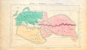
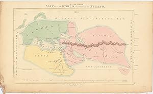
Contact seller5-star sellerThis colorful map came from Crams 1898 Universal Atlas - Geographical, Astronomical and Historical. In 1869 the George F. Cram Company was born and the Cram name quickly became synonymous with accuracy and innovation. This map shows the world according to Eratosthenes & Strabo. The two maps are on one page. This map measures 9.7…5 inches by 13 inches.
Language: English
Published by Call & Inglis, Edinburgh 1850
- Map
Seller: Anah Dunsheath RareBooks ABA ANZAAB ILAB, Auckland, NZ, New ZealandAnah Dunsheath RareBooks ABA ANZAAB ILAB
Contact seller5-star sellerCondition: Used - Very good
US$ 85.58
US$ 25.00 shippingShips from New Zealand to U.S.A.Quantity: 1 available
No Binding. Condition: Very Good. Hand-coloured map centred on the Mediterranean based on the map made by the Classical Greek geographer Strabo from his work "Geographica". Map published by the prominent Edinburgh map-making firm of Call & Inglis, established in 1810. Excellent copy of an interesting classical map. 52.5 x 32 cm,… free floating on card.
Published by EdinburghGall & Inglis . 1850
- Map
Seller: Robert Frew Ltd. ABA ILAB, London, , United KingdomRobert Frew Ltd. ABA ILAB
Contact seller5-star sellerCondition: Used
US$ 103.57
US$ 13.41 shippingShips from United Kingdom to U.S.A.Quantity: 1 available
Original engraved map of the world according to Greek geographer Strabo (64 or 63 BC - c. AD 24) with original hand colouring. Map dimensions 25.5 x 41 cm, overall sheet size 31 x 52 cm. Some toning and fraying to margins not affecting map, especially in bottom left corner which has been affected by damp-staining.

Seller: Bartele Gallery - The Netherlands, Langweer, FRL, NetherlandsBartele Gallery - The Netherlands
Contact seller5-star sellerCondition: Used
US$ 536.42
US$ 19.67 shippingShips from Netherlands to U.S.A.Quantity: 1 available
Veteris Orbis Climata ? Ancient World Map after Strabo by Cellarius, 1731 This fascinating hand-colored antique map, titled Veteris Orbis Climata ex Strabone, is a classical representation of the known world as described by the Greek geographer Strabo over two millennia ago. Published in 1731 as part of Christoph Cellarius' infl…uential atlas Notitia Orbis Antiqui, this map captures an ancient worldview, blending early geography with Enlightenment-era printing skill. Strabo's geography, which heavily influenced classical understanding of the world, is vividly illustrated here. The continents of Europe, Asia, and parts of Africa dominate the composition, while vast unexplored regions?such as sub-Saharan Africa, Japan, the Korean Peninsula, and the entire Pacific?are notably absent. Australia and Oceania are also missing, reflecting the limitations of geographic knowledge in the classical period. Particularly striking is the arc-shaped format of the map, suggesting the division of the earth into climatic zones (climata) according to ancient theories. The top of the map features an allegorical representation of the heavens, with a sunburst, clouds, and celestial figures illuminating the ancient world below. The equatorial and polar regions are represented but not fully understood, and the depiction of the northeast passage is unusually prominent, hinting at speculative ancient routes. Produced using copper engraving and later hand-colored, this map is both historically and visually compelling. It originally appeared in one of the early editions of Cellarius' Notitia Orbis Antiqui, a work that remained popular for over a century and was printed in Amsterdam, London, and other European cities. Cellarius' maps were lauded for their scholarly basis and elegant execution. Condition report: Good. Later hand-coloring. Minor foxing overall, but still a very decorative and interesting print. The central vertical folding line is original and typical for maps of this period. The paper is not particularly strong but remains complete and intact, with no repairs, tears, wormholes, or wrinkles. Verso: blank. Framing tips: This map would suit a classic gold-leaf or ebonized wood frame. Use an off-white or light parchment-colored mat to echo the aged paper and highlight the vibrant coloring.


