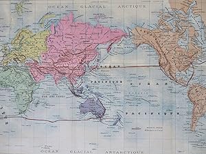
Mercator's World: Maps (87 results)

Language: English
Published by The Offices of the Amalgamated Press, London 1907
- Softcover
- First Edition
- Map
Seller: Kilrimund Books, Gateside, FIFE, United KingdomKilrimund Books
Contact seller5-star sellerCondition: Used - Very good
US$ 27.29
US$ 29.14 shippingShips from United Kingdom to U.S.A.Quantity: 1 available
Soft cover. Condition: Very Good. 1st Edition. Map extract from the Harmsworth Universal Atlas and Gazetteer (circa 1907). Single sheet (measuring 510 mm x 392 mm) with single fold as issued. Clean and crisp condition.
 More images
Language: English
Published by American Map Company, Inc., New York 1940
- Map
Seller: Herdbooks, State College, PA, U.S.A.Herdbooks
Contact seller5-star sellerCondition: Used - Fair
US$ 40.00
US$ 3.00 shippingShips within U.S.A.Quantity: 1 available
Condition: Fair. Stored folded in nonsmoking environment. Many of the folds are separating, but no piece is detached from the whole; normal age discoloration. Large 38" x 50" size. Colorprint Series 9455-D published in 1940. Featuring all Political Divisions, Principal Cities and Shortest Steamship Distances Between Ports. Featu…ring Flags of the Nations divided into those of the United Nations, Axis Powers, and Neutral Countries. Detailed maps of The Solomon Islands Area, The Philippines Islands, Japan, India, Burma and Adjacent Areas, and Europe Including Mediterranean Area and the Near-East.

- Softcover
- Map
Seller: AHA-BUCH GmbH, Einbeck, GermanyAHA-BUCH GmbH
Contact seller5-star sellerCondition: New
US$ 55.77
US$ 73.15 shippingShips from Germany to U.S.A.Quantity: 2 available
Taschenbuch. Condition: Neu. Neuware - This guide to Mitchell's map of the world offers useful background information and a comprehensive index of the map's features. With detailed descriptions of the countries and regions represented, as well as a discussion of the different geographical regions of the world, this guide is an e…ssential tool for anyone using Mitchell's world map.This work has been selected by scholars as being culturally important, and is part of the knowledge base of civilization as we know it.This work is in the 'public domain in the United States of America, and possibly other nations. Within the United States, you may freely copy and distribute this work, as no entity (individual or corporate) has a copyright on the body of the work.Scholars believe, and we concur, that this work is important enough to be preserved, reproduced, and made generally available to the public. We appreciate your support of the preservation process, and thank you for being an important part of keeping this knowledge alive and relevant.

- Hardcover
- Map
Seller: AHA-BUCH GmbH, Einbeck, GermanyAHA-BUCH GmbH
Contact seller5-star sellerCondition: New
US$ 71.36
US$ 74.18 shippingShips from Germany to U.S.A.Quantity: 2 available
Buch. Condition: Neu. Neuware - This guide to Mitchell's map of the world offers useful background information and a comprehensive index of the map's features. With detailed descriptions of the countries and regions represented, as well as a discussion of the different geographical regions of the world, this guide is an essentia…l tool for anyone using Mitchell's world map.

Published by 1881. 17.25in x 14in (44 x 36cm) 1881
- Map
Seller: R.G. Watkins Books and Prints, Ilminster, SOMER, United KingdomR.G. Watkins Books and Prints
Contact seller5-star sellerCondition: Used - Very good
US$ 20.47
US$ 37.09 shippingShips from United Kingdom to U.S.A.Quantity: 1 available
No Binding. Condition: Very good. Dust Jacket Condition: No Jacket issued. Colour map, from Letts's "Popular Atlas", central fold.
 More images
- Map
Seller: RareMapsandBooks, Dover, NH, U.S.A.RareMapsandBooks
Contact seller4-star sellerCondition: Used - Good
US$ 27.50
US$ 6.95 shippingShips within U.S.A.Quantity: 1 available
Condition: good. Erdkarte in Mercator's Projection.(Old Maps, 19th Century Maps, World Map, Mercator's Projection, Ocean Currents, North & South America, Africa, Europe, Asia, Oceania). Issued 1886, Glogau by Flemming. Mid 19th century color lithographed map. Of interest for the numerous place names assigned along the Antarctic…coastline across the bottom. Also shows the basic flow patterns of ocean currents. Nice looking example, pleasing age patina, any minor age flaws easy to overlook or forgive. Original center fold as issued. Sheet Measures c. 15 1/2" H x 18" W. Engraved Area Measures c. 13" H x 13" W. Cartographic Reference (s):Tooley'sà Dictionary of Mapmakers, vol 2.[R28179].

Language: English
Published by Colton, New York 1864
- Map
Seller: Anah Dunsheath RareBooks ABA ANZAAB ILAB, Auckland, NZ, New ZealandAnah Dunsheath RareBooks ABA ANZAAB ILAB
Contact seller5-star sellerCondition: Used - Good
US$ 94.11
US$ 25.00 shippingShips from New Zealand to U.S.A.Quantity: 1 available
No Binding. Condition: Good. An attractive coloured map of the world decorated with ships, compass, and routes of various voyagers such as Vancouver, Cook etc. 52 x 73 cm folding into a neat small cloth cover. Some repair to folds. A most attractive map with a highly decorative surround.
 More images
- Map
Seller: RareMapsandBooks, Dover, NH, U.S.A.RareMapsandBooks
Contact seller4-star sellerCondition: Used - Good
US$ 32.50
US$ 6.95 shippingShips within U.S.A.Quantity: 1 available
Condition: good. The World on Mercator's Projection Showing the Course of the Chief Ocean Currents and the Navigation Tracks Between the Principal Ports.(World Map, Mercator's Projection, North America, South America, Asia, Oceania, Africa, Europe, Sea Lanes, Shipping Routes). Issued 1882, Edinburgh by Blackie & Son. Very detail…ed late 19th century color lithographed map. Well preserved, nice looking example with pleasing age patina. 3" closed split at bottom of centerfold. Original center fold as issued. Sheet Measures c. 15" H x 22" W. Engraved Area Measures c. 13 1/2" H x 19 3/4" W. Cartographic Reference (s):Tooley'sà Dictionary of Mapmakers, vol. 1.[R23164].
 More images
- Map
Seller: RareMapsandBooks, Dover, NH, U.S.A.RareMapsandBooks
Contact seller4-star sellerCondition: Used - Good
US$ 32.50
US$ 6.95 shippingShips within U.S.A.Quantity: 1 available
Condition: good. A Chart of Magnetic Curves of Equal Variation by Peter Barlow.(Old Maps, 19th Century Maps, World Maps, North America, South America, Africa, Europe, Asia, Oceania). Issued 1844, Edinburgh by A. & C. Black. Map by Aikman. Mid 19th century lithographed map. Well preserved, nice looking example with pleasing age p…atina. Sheet Measures c. 12 1/4" H x 16 3/4" W. Printed Area Measures c. 10 1/4" H x 14 3/4" W. Cartographic Reference (s):Tooley'sà Dictionary of Mapmakers, vol. 1.[R30841].
 More images
- Map
Seller: RareMapsandBooks, Dover, NH, U.S.A.RareMapsandBooks
Contact seller4-star sellerCondition: Used - Good
US$ 32.50
US$ 6.95 shippingShips within U.S.A.Quantity: 1 available
Condition: good. Erdkarte in Mercator's Projection.(Old Maps, 19th Century Maps, World Maps, Mercator's Projection, Ocean Currents). Issued 1885, Glogau by C. Flemming. Uncommon and very detailedà 19th century German color lithographed map with original outline hand color. Well preserved, nice looking example with pleasing age p…atina. Original center fold as issued. Maps of this era display endless variations as political boundaries change. Sheet Measures c. 15 7/8" H x 18" W. Printed Area Measures c. 13" H x 15 1/2" W. Cartographic Reference (s):Tooley's Dictionary of Mapmakers, vol. 2,[R29274].
 More images
- Map
Seller: RareMapsandBooks, Dover, NH, U.S.A.RareMapsandBooks
Contact seller4-star sellerCondition: Used - Good
US$ 32.50
US$ 6.95 shippingShips within U.S.A.Quantity: 1 available
Condition: good. The World on Mercator's Projection.(Old Maps, 19th Century Maps, World Map, Mercator's Projection, North America, South America, Africa, Europe, Asia, Australia, Oceania, New Zealand, Hawaii). Issued 1830, London by Bull. Printed by Perkins & Bacon for Starling. Charming little early 19th century engraved miniat…ure map with attractive original hand color. Remains a clean, fresh, nice looking example with a pleasing age patina. Sheet Measures c. 4 1/4" H x 6 1/2" W. Engraved Area Measures c. 3 1/2" H x 5 1/2" W. Cartographic Reference (s):Tooley's Dictionary of Mapmakers, vol. 1.[R32293].
 More images
Language: English
- Map
Seller: Old Paper Old Ink, Murray, KY, U.S.A.Old Paper Old Ink
Contact seller4-star sellerCondition: Used - Very good
US$ 79.95
US$ 4.50 shippingShips within U.S.A.Quantity: 1 available
No Binding. Condition: Very Good. Anonymous Gentleman's Magazine. A Map of the World, on Mercators Projection. 1755. This is a copper plate engraved map with outline hand coloring. It shows the limits of European geographical knowledge as of the middle 18th. century. Missing "pieces" include the lands west of Hudson's Bay, most…of Greenland, the polar regions of Siberia, parts of Australia, Antarctica, Sandwich Islands, etc. There are hints of land such as the Alaskan coast on the Bering Sea. A speck of land below Africa called Cape Circumcision (yikes!), some apocryphal islands, and some land south of Siberia discovered in 1741. The Americas show the colonial boundaries of that era, and Africa is still a mystery, with Hottentots, Monomotapa, and Negroland. *** Clean, sharp impression with good color, blank verso. Two vertical folds, as issued. Top margin is partially close cropped. *** Sheet is approx. 8 inches high by 12 inches, image 7.25 inches high by 11 inches.
 More images
- Map
Seller: RareMapsandBooks, Dover, NH, U.S.A.RareMapsandBooks
Contact seller4-star sellerCondition: Used - Good
US$ 34.00
US$ 6.95 shippingShips within U.S.A.Quantity: 1 available
Condition: good. Untitled.(Old Maps, 19th Century Maps, World Maps, Mercator's Projection, Circumnavigation, Americas, Africa, Europe, Asia, Oceania). Issued 1895, Paris by Plon & Co. Engraved by Erhard. Based on the Atlas map of Mr. Bonnefont. Uncommon late 19th century antique color lithographed map. Well preserved, nice looki…ng example with pleasing age patina. Original fold lines as issued. Sheet Measures c. 11 3/4" H x 15 1/4" W. Engraved Area Measures c. 10" H x 14 3/4" W. Cartographic Reference (s):Tooley's Dictionary of Mapmakers, vol. 3.[R32416].
 More images
- Map
Seller: RareMapsandBooks, Dover, NH, U.S.A.RareMapsandBooks
Contact seller4-star sellerCondition: Used - Good
US$ 34.00
US$ 6.95 shippingShips within U.S.A.Quantity: 1 available
Condition: good. Erdkarte in Mercators Projection sammt Darsatellung der Meerestromungen.(Old Maps, 19th Century Maps, World Maps, Mercator's Projection, Ocean Currents, Gulf Stream). Issued 1858-59, Vienna by Obenheimer. Map by A. Skrzeszewski. Uncommon and nice mid 19th century color lithographed German made map. Well preserve…d, nice looking example with pleasing age patina. Original center fold as issued. Sheet Measures c. 18" x 11 1/2". Engraved Area Measures c. 15" x 10". Cartographic Reference (s):Tooley's Dictionary of Mapmakers, vol. 4.[R33771].
 More images
- Map
Seller: RareMapsandBooks, Dover, NH, U.S.A.RareMapsandBooks
Contact seller4-star sellerCondition: Used - Good
US$ 34.00
US$ 6.95 shippingShips within U.S.A.Quantity: 1 available
Condition: good. The World on Mercator's Projection.(Old Maps, 19th Century Maps, World Maps, Mercator's Projection, Africa, Europe, Asia, Oceania, North America, South America). Issued 1853, Edinburgh by A. & C. Black. Mid 19th century engraved map with attractive original hand color. Remains a nice looking example with a pleas…ing age patina. Any age flaws mostly minor and easy to overlook or forgive. Sheet Measures c. 12 1/2" H x 17 1/2" W. Engraved Area Measures c. 12 1/2" H x 15 1/4" W. Cartographic Reference (s):Tooley's Dictionary of Mapmakers, vol. 1.[R29878].
 More images
- Map
Seller: RareMapsandBooks, Dover, NH, U.S.A.RareMapsandBooks
Contact seller4-star sellerCondition: Used - Good
US$ 37.50
US$ 6.95 shippingShips within U.S.A.Quantity: 1 available
Condition: good. Mappe Monde Suivant la Projection de Mercator.(Old Maps, 19th Century Maps, World Map, Mercator's Projection, Africa, Europe, Asia, Australia, Oceania, North America, South America). Issued c. 1870, Paris by Fosset. Map by Fremin. Engraved by Jacobs. Late 19th century engraved map with original hand color. Well…preserved, nice looking example with pleasing age patina. Original center fold as issued. Sheet Measures c. 15 1/2" H x 21" W. Engraved Area Measures c. 11 1/2" H x 16 3/4" W. Cartographic Reference (s):Tooley'sà Dictionary of Mapmakers, vol. 4.[R28152].
 More images
- Map
Seller: RareMapsandBooks, Dover, NH, U.S.A.RareMapsandBooks
Contact seller4-star sellerCondition: Used - Good
US$ 37.50
US$ 6.95 shippingShips within U.S.A.Quantity: 1 available
Condition: good. Wereld-Kaart in Mercator's Projectie.(Old Maps, 19th Century Maps, World Maps, Exploration Routes, North America, South America, Europe, Africa, Asia, Australia). Issued 1876, Leiden, Netherlands by van Goor. Map by Otterloo. Very scarce large mid 19th century engraved map with original hand color. Well preserve…d, nice looking example with pleasing age patina. Original center fold as issued. Sheet Measures c. 22" H x 17 1/2" W. Engraved Area Measures c. 18" H x 14 1/2" W. Cartographic Reference (s):Tooley's Dictionary of Mapmakers, vol. 3.[R28099].
 More images
- Map
Seller: RareMapsandBooks, Dover, NH, U.S.A.RareMapsandBooks
Contact seller4-star sellerCondition: Used - Good
US$ 37.50
US$ 6.95 shippingShips within U.S.A.Quantity: 1 available
Condition: good. Chart of the World on Mercator's Projection - Principal Cities of the Old World.(Old Maps, 19th Century Maps, World Maps, Mercator's Projection, London, Paris, Berlin, St. Petersburg, Vienna, Cairo). Issued 1887-90, Chicago by Cram for the scare large folio Standard American Atlas. Large late 19th century color…lithographed map. Not to be confused with the far more common later Cram maps, this much scarcer earlier version is a unique format with a short-lived production time. Six world city plans across the top, various statistics downthe sides which include wealth, money in circulation, military info, as well as telegraph lines Map remains clean, minor 1" split at base of centerfold. Original center-fold as issued. Sheet Measures c. 17 1/2" H x 25" W. Printed Area Measures c. 16" H x 22" W. Cartographic Reference (s):Tooley's Dictionary of Mapmakers, vol. 1.[R30751].
 More images
- Map
Seller: RareMapsandBooks, Dover, NH, U.S.A.RareMapsandBooks
Contact seller4-star sellerCondition: Used - Good
US$ 37.50
US$ 6.95 shippingShips within U.S.A.Quantity: 1 available
Condition: good. The World on Mercator's Projection.(Old Maps, 20th Century Maps, World Maps, Mercator's Projection, Interwar Years, U. S. S. R, China, Japan, Australia, British India., Turkey, United States, Brazil, Mexico). Issued c. 1930's, Indianapolis, Indiana by George Cram, for Samuel Ward MFG. An example of a private bus…iness company distributing maps bought from Cram with their company name on them. Early 20thà century color lithographed map. Depicts nations which arose post-WWI. Well preserved, nice looking example with pleasing age patina. Original fold lines as issued. Sheet Measures c. 14" H x 20" W. Cartographic Reference (s):Tooley's Dictionary of Mapmakers, vol. 1.[B6437].
 More images
- Map
Seller: RareMapsandBooks, Dover, NH, U.S.A.RareMapsandBooks
Contact seller4-star sellerCondition: Used - Good
US$ 37.50
US$ 6.95 shippingShips within U.S.A.Quantity: 1 available
Condition: good. Chart of the World on Mercator's Projection.(Old Maps, 19th Century Maps, World Map, Mercator's Projection, Africa, Europe, Asia, Oceania, North America, South America, Ocean Currents, Shipping Routes). Issued 1895, Philadelphia by M. Bradley & Bros. Large oversize late 19th century map with original hand color.… Well preserved, nice looking clean example with pleasing age patina. Original center fold as issued. Sheet Measures c. 18 3/4" H x 25 14/2" W. Printed Area Measures c. 15 1/2" H x 20" W. Cartographic Reference (s):Tooley's Dictionary of Mapmakers, vol. 1.[R32002].

Language: English
Published by London 1812
- Map
Seller: Antiquariat Steffen Völkel GmbH, Seubersdorf, GermanyAntiquariat Steffen Völkel GmbH
Contact seller5-star sellerCondition: Used
US$ 411.93
US$ 34.28 shippingShips from Germany to U.S.A.Quantity: 1 available
Zwei seltene handkolorierte Karten aus John Pinkerton's "Modern Atlas" von 1815. Von 2 Platten gedruckt, zusammensetzbar. -- Blatt-Maße: ca. 75 x 55 cm. -- gut erhalten. || Rare complete set of two handcolored engraved map out of John Pinkerton's "Modern Atlas" published in London in 1815. Printed on two plates, can be joined to…gether. -- in good condition. || Dies ist ein Original! - Kein Nachdruck! - Keine Kopie! -- This is an original! - No copy! - No reprint! // Wir, das Antiquariat Steffen Völkel, kaufen und verkaufen alte Bücher, Handschriften, Zeichnungen, Autographen, Grafiken und Fotografien. Wir sind stets am Ankauf von kompletten Bibliotheken, Sammlungen und Nachlässen interessiert. Sprache: Englisch Gewicht in Gramm: 1550.

Language: English
Published by Longman, Hurst, Rees & Orme, Paternoster Row, London 1807
- First Edition
- Map
Seller: THOMAS RARE BOOKS, Yaxley, SUFFOLK, United KingdomTHOMAS RARE BOOKS
Contact seller4-star sellerCondition: Used - Fine
US$ 477.55
US$ 19.87 shippingShips from United Kingdom to U.S.A.Quantity: 1 available
No Binding. Condition: Fine. 1st Edition. Original early 19th century MAP OF THE WORLD On MERCATORS PROJECTION BY AARON ARROWSMITH. A FINE, CLEAN AND DARK IMPRESSION. Original folding plate covering THE WHOLE WORLD printed on heavy paper dated 1807. A scarce example and in fine un-coloured original condition. 41x27cms. Double-pa…ge folding map.Engraved by Lodge.A LOVELY COPY.
Language: English
Published by James Wyld, London 1841
- Map
Seller: Anah Dunsheath RareBooks ABA ANZAAB ILAB, Auckland, NZ, New ZealandAnah Dunsheath RareBooks ABA ANZAAB ILAB
Contact seller5-star sellerCondition: Used - Very good
US$ 1,061.63
US$ 25.00 shippingShips from New Zealand to U.S.A.Quantity: 1 available
No Binding. Condition: Very Good. Coloured engraving of a map of the world dedicated to the Queen early in Victoria's reign. With substantial geographic details labelled (including D'Urville and Wilkes discoveries of the Antarctic on the lower right, "New Zeeland"). James Wyld, a prolific publisher of maps, was official geograph…er to Queen Victoria and Prince Albert. Free on card 96 x 66 cm. Image shows wrinkles form the mylar cover. Very clean, Wyld map.
Published by 1881. Each 17.25in x 14in (44 x 36cm) 1881
- Map
Seller: R.G. Watkins Books and Prints, Ilminster, SOMER, United KingdomR.G. Watkins Books and Prints
Contact seller5-star sellerCondition: Used - Very good
US$ 54.58
US$ 37.09 shippingShips from United Kingdom to U.S.A.Quantity: 1 available
No Binding. Condition: Very good. Dust Jacket Condition: No Jacket issued. Colour map, from Letts's "Popular Atlas", central fold.
 More images
- Map
Seller: RareMapsandBooks, Dover, NH, U.S.A.RareMapsandBooks
Contact seller4-star sellerCondition: Used - Good
US$ 42.50
US$ 6.95 shippingShips within U.S.A.Quantity: 1 available
Condition: good. Chart of the World On Mercators Projection - Palestine.(Old Maps, 19th Century Maps, World Maps, Mercator's Projection, Holy Land, Palestine, Israel, Lake Torrens, Texas, Utah, California, Oregon, Florida). Issued 1882, Toronto, Ontario, Canada. Lithographed by Rolph, Smith & Co. Interesting and quite scarce 19t…h century antique lithographed map with original hand color. Notable for its unusual imprint location of Canada as well as the large detailed Palestine inset at right. A most unusual pairing of geographical locations as well as a mixture of scales. The world map exceeds 360' while the Palestine map is given in a scale 5 mile multiples. Lake Torrens within Australia lower left shows an early erroneous shape, southern continent coastline hinted at by place names & large blank spaces. Interestingly, within North America, the only states named are Texas, Utah, California, Oregon & Florida. Sheet displays some light signs of age, including small minor inoffensive scattered spotting. Otherwise clean and visually attractive example. Original fold line as issued. Sheet measures c. 17 1/4" x 26 1/2"Engraved area measures c. 15 1/2" x 25 1/2"[R35647].
 More images
- Map
Seller: RareMapsandBooks, Dover, NH, U.S.A.RareMapsandBooks
Contact seller4-star sellerCondition: Used - Good
US$ 42.50
US$ 6.95 shippingShips within U.S.A.Quantity: 1 available
Condition: good. Map of the World on the Mercator Projection Exhibiting the American Continent as Its Centre.(Old Maps, 19th Century Maps, World Maps, Asia, Australia, North America, South America, Africa, Europe, Polynesia, Hawaii, New Zealand, Australia). Issued 1867-9, Philadelphia by S. Augustus Mitchell. There are many vari…ant issues of this map, with differing borders and interior details. A comparison with other Mitchell maps of the 1860's-80's era will reveal this on close inspection. Mid 19th century antique engraved map with original hand color. Decorative border greatly enhances visual appeal. Numerous exploration tracks shown across the oceans, including Capt. Cook, the U. S. Exploring Exped., Capt. Ross and Capt. Gore. Note the incorrect prominent hook shape assigned to Lake Torrens within Southern Australia. Well preserved, nice looking example with pleasing age patina. Original center fold as issued. Sheet Measures c. 25" x 15". Engraved Area Measures c. 22" x 14". Cartographic Reference (s):Tooley's Dictionary of Mapmakers, vol. 3.[R33996].

Published by LondonHenry Teesdale . 1845
- Hardcover
- Map
Seller: Robert Frew Ltd. ABA ILAB, London, , United KingdomRobert Frew Ltd. ABA ILAB
Contact seller5-star sellerCondition: Used
US$ 7,845.48
US$ 13.25 shippingShips from United Kingdom to U.S.A.Quantity: 1 available
Original large-format map of the world on Mercator's projection (130 x 198 cm), engraved by John Dower and with fine original colour, sectionalised and laid onto two sections of linen as issued, each edged with green silk and measuring 130 x 99 cm, folding between publisher's original morocco covers (38 x 27 cm) with gilt foliat…e frame enclosing gilt title, marbled endpapers. Some very faint occasional foxing, upper cover with scratch mark to lower centre, overall a particularly fine example of this impressive map. Fine large format map of the world, which provides fantastic detail throughout, engraved by John Dower and published by Henry Teesdale. It is one of the few English maps to recognise the Republic of Texas (England itself did not), and depict its most ambitious boundaries. It is also the most complete map to show a complete northwest passage following the Deese-Simpson Expedition. Perhaps the most interesting part of the map is its treatment of the search for the Northwest Passage and the extensive annotations showing the routes of various discoverers throughout the world. With respect to the Northwest Passage, there are dozens of annotations identifying the British and other discoveries in the region, with section of text describing Arctic exploration up to 1833 and then additional notes on the map discussing discoveries up to October 1839, noting: "This Coast was Explored by Messrs. Dease and Simpson under the Honble. Hudson's Bay Company which completes the North West Passage Octr. 1839" Off the coast of Alaska, a number of different tracks of exploration are shown, up to Captain Beechey in 1826, with a further note in the interior further discussing P.W. Deawe and Thos. Simpson's expedition beginning at Fort Chipewyan June 1, 1837, traveling north to the Arctic Sea and then to Alaska. In the Southern Hemisphere, there are a number of early Antarctic discoveries shown. Teesdale was a London-based map publisher. He was an early Fellow of the Royal Geographical Society, elected in 1830. Teesdale partnered with John Hordan and William Colling Hodson, but this arrangement dissolved in 1832. Afterward, he continued to work on his own and periodically with colleagues like John Crane Dower, Christopher Greenwood, Josiah Henshall and others. He published a variety of atlases and separately-issued maps. His business was quite successful, as he registered as a partner in the Royal Bank of Scotland in 1845.
 More images
Published by George Philip & Son, London 1870
- Hardcover
- First Edition
- Map
Seller: Michael Treloar Booksellers ANZAAB/ILAB, Adelaide, SA, AustraliaMichael Treloar Booksellers ANZAAB/ILAB
Contact seller5-star sellerCondition: Used - Near fine
US$ 1,801.06
US$ 24.00 shippingShips from Australia to U.S.A.Quantity: 1 available
Hardcover. Condition: Near fine. First Edition. London, George Philip & Son, [late 1870s]. Approximately 1420 × 1880 mm (printed surface), comprising eight sheets printed in colour (printed surface approximately 710 × 470 mm each), each comprising two panels mounted as a pair on linen, with its respective portion of the key map…mounted on the verso. The maps are neatly scored along the inner borders so that the margins can be folded under and the sheets laid together seamlessly (as issued). One crease and surface crack to the top corner of Sheet 8 (clear of the printed surface); a few trifling marks; in near-fine condition, housed in the original presentation portfolio of half red roan and morocco-grain cloth, elaborately blocked in gilt (covers a little worn, with splits to the spine expertly stabilised). There are four inset maps in the bottom half: the two hemispheres; winds; heights and depths; and natural productions. An elaborate gilt-lettered blue morocco presentation label is mounted on one of the flaps of the portfolio; it reads: 'Presented to Mr. W. Whittam by the employés of Harrold Brothers, Adelaide, 31st March, 1882'.

Published by GothaJustus Perthes . 1897
- Hardcover
- Map
Seller: Robert Frew Ltd. ABA ILAB, London, , United KingdomRobert Frew Ltd. ABA ILAB
Contact seller5-star sellerCondition: Used
US$ 2,046.65
US$ 13.25 shippingShips from United Kingdom to U.S.A.Quantity: 1 available
Large folding chart of the world (overall dimensions 97 x 148 cm). The sea with full colour, original outline colour to territorial borders and coastlines. Numerous geographical and commercial references highlighted in original colour including sailing routes, telegraph lines and ocean currents. Vignette world charts to the lowe…r corners outlining the locations of telegraph lines and the courses of the prevailing winds. Another panel to the centre of the lower edge with twin hemisphere projections. One panel of general explanatory text, another panel of text outlining the principal steamship routes. The whole dissected into 32 sections and backed onto linen, housed in publisher's original green cloth slipcase. A superb example.

Published by LondonEdward Stanford 55 Charing Cross Jan. 1st . 1885
- Hardcover
- Map
Seller: Robert Frew Ltd. ABA ILAB, London, , United KingdomRobert Frew Ltd. ABA ILAB
Contact seller5-star sellerCondition: Used
US$ 1,296.21
US$ 13.25 shippingShips from United Kingdom to U.S.A.Quantity: 1 available
Original engraved map of the world (69.5 x 103.5 cm) with outline colour, dissected into 40 panels and laid onto linen, two panels with marbled endpapers, folding into original brown cloth slipcase with publisher's yellow title label to upper portion. The map recording steam routes including travel times and underwater telegraph… cables; map inserts of the Arctic and Antarctica (polar projection) in lower right and lower left quadrants. Generally an excellent, well preserved copy. Edward Stanford, Fellow of the Royal Geographical Society, acquired the plates and stock of John Arrowsmith in 1874.


