Order Total (1 Item Items):
Shipping Destination:

Modern World Atlas, First Edition (26 results)
Skip to main search results
Product Type
- All Product Types
- Books (23)
- Magazines & Periodicals
- Comics
- Sheet Music
- Art, Prints & Posters (1)
- Photographs
- Maps (2)
-
Manuscripts &
Paper Collectibles
Condition
- All Conditions
- New
- Used
Binding
Collectible Attributes
- First Edition
- Signed
- Dust Jacket
- Seller-Supplied Images (18)
- Not Printed On Demand
Free Shipping
Seller Location
Seller Rating
-
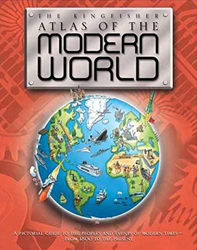
The Kingfisher Atlas of the Modern World
Published by Roaring Brook Press, 2007
ISBN 10: 0753460343ISBN 13: 9780753460344
Book First Edition
Condition: Good. 1st Edition. Former library book; may include library markings. Used book that is in clean, average condition without any missing pages.
-
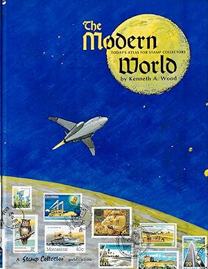
THE MODERN WORLD: Today's Atlas for Stamp Collectors.
Published by Van Dahl Pub.,, Albany, OR:, 1987
ISBN 10: 0934466106ISBN 13: 9780934466103
Book First Edition
Hardcover. Condition: Fine. 1st ed. 256 pp. First edition. Binding tight, glossy boards clean, no dust jacket as issued, internally fine with no highlighting, no underlining, no marginal notes, no price clip. See additional image provided.
More buying choices from other sellers on AbeBooks
Used offers from US$ 10.00
Also find First Edition
-

THE MODERN STANDARD DICTIONARY AND WORLD ATLAS
Published by ODHAMS PRESS, 1936
Seller: K Books Ltd ABA ILAB, York, YORKS, United Kingdom
Association Member: ABA ILAB PBFA
Seller Rating:

Book First Edition
Hardcover. Condition: Very Good. 1st Edition. A NICE COPY , VERY GOOD CONDITION , EXCELLENT VALUE.
-
The Modern Standard Dictionary and World Atlas
Published by Odhams Press Ltd, London, 1937
Seller: J J Basset Books, bassettbooks, bookfarm.co.uk, Peter Tavy, United Kingdom
Seller Rating:

First Edition
Black Cloth. Condition: Good Repaired Spine. No Jacket. Illustrated with Over 500 Drawings (illustrator). First Edition. Please email for further details. Size: 8vo - over 7�" - 9�". Not Signed or Inscribed. HARDBACK.
-
EUROPEAN HISTORY ATLAS - Student Edition - Ancient, Medieval and Modern European and World History, Adapted from the Large Wall Maps
Published by Denoyer-Geppert Company, Chicago, Illinois, 1951
First Edition
Cloth-bound Softcover. Condition: Very Good. Color and b&w illustrations (illustrator). First Edition stated. xvi, 62pp [1951 blue-pencil ownership on title page; mild corner and edge wear] Size: 4to - over 9�" - 12" tall.
-
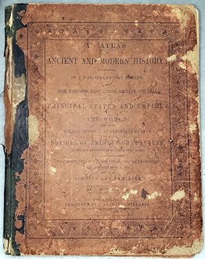
An Atlas of Ancient and Modern History; Presenting, in a Chronological Series, The Rise, Progress, Revolutions, Decline and Fall of the Principal States and Empires of the World; Comprising Details of the Most Important Events.
Published by S. Augustus Mitchell, Philadelphia, 1845
Book First Edition
Quarter Leather. Condition: Poor+. Dust Jacket Condition: No Dust Jacket. First Edition. Folding time lines from 2300 BC to 1800 AD. Covers are severely worn. Leather over spine is deteriorated and mostly lacking. Paper paste over top and bottom boards, is chipped, worn, and torn. Still, most of the text on the covers remains legible. Contents are loosened and are partially or completely detached. There is a stain affecting the bound edges/folds of all contents, though text there also remains clear and legible. Due to size, additional charges will apply for International shipping.
-
The Edinburgh World Atlas, Or, Advanced Atlas Of Modern Geography
Published by John Batholomew & Son Ltd Edinburgh, 1954
Map First Edition
Folio(38.2x25.4) HB 1st edition 108pp+51pp index. Navy blue cloth boards with gilt lettering & illus-a little edge wear , minimal marking else v.good. No dust jacket. Endpapers illustrate 'Ruysch World Map' published in 1508. Minimal age discolouration to endpapers else internally near fine/fine. (1295g) Heavy volume may rquire extra shipping costs.
-
![Seller image for Libby's modern world atlas [promotional vintage atlas, ca. 1927] for sale by MW Books](https://pictures.abebooks.com/inventory/md/md15013502013.jpg)
Libby's modern world atlas [promotional vintage atlas, ca. 1927]
Published by London : Libby, McNeill & Libby, ca.1927, 1927
First Edition
First Edition. Very good paperback copy; wrappers somewhat dust-toned and edge-nicked. Remains quite well-preserved overall.; 8vo 8" - 9" tall; 16 pages; Vintage atlas advertising a range of Libby's tinned fruit, vegetables, meat and milk. 16 p. : ill., maps ; 27 cm. Subjects: Atlases -- Maps -- Vintage maps. 1 Kg.
-
![Seller image for Libby's modern world atlas [promotional vintage atlas, ca. 1927] for sale by MW Books Ltd.](https://pictures.abebooks.com/inventory/md/md15013191022.jpg)
Libby's modern world atlas [promotional vintage atlas, ca. 1927]
Published by London : Libby, McNeill & Libby, ca.1927, 1927
First Edition
First Edition. Very good paperback copy; wrappers somewhat dust-toned and edge-nicked. Remains quite well-preserved overall.; 8vo 8" - 9" tall; 16 pages; Vintage atlas advertising a range of Libby's tinned fruit, vegetables, meat and milk. 16 p. : ill., maps ; 27 cm. Subjects: Atlases -- Maps -- Vintage maps. 1 Kg.
-
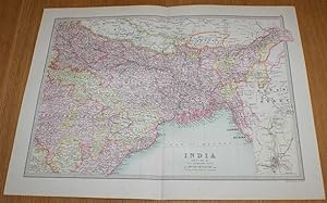
Map of India (Section 2) covering parts of modern day central and eastern India, Bangladesh, Bhutan and Nepal with small inset plan of Calcutta - Sheet 47 Disbound from the 1890 'The Library Reference Atlas of the World'
Published by Macmillan and Co., London, 1890
First Edition
Softcover. Condition: Very Good. Dust Jacket Condition: No Dust Jacket. First Edition. Single disbound coloured map sheet from John Bartholomew's Library Reference Atlas. Section 2 only of 3 covering India (as was in 1890). Approx size 35 x 46 cm, vertical centre fold. Corners lightly worn. Map is clean, crisp, clear and bright. Sheet covers parts of modern day eastern India, Bangladesh, Bhutan and part of Nepal including: Lucknow, Patna, Allahabad, Narsinghpur, Bandara, Kanker, Lahara, Sambalpur, Bhagalpur, Bengal, Chutia Nagpur, Jashpur, Calcutta, Assam, Sikkim, Lakhimpur, Manipur, Chittagong, Dacca, Khatmandu, Punakha, etc. Small inset plan of Calcutta in lower right corner of sheet. No dust jacket, as published. Quantity Available: 1. Shipped Weight: under 1 kg. Pictures of this item not already displayed here available upon request. Inventory No: 45020124016. For International tracked shipping please select the Priority shipping service.
-
Map of 'India, Physical and Political' - Sheet 45 disbound from the 1890 'The Library Reference Atlas of the World' including Ceylon (Sri Lanka), Nepal, Bhutan and modern day Bangladesh
Published by Macmillan and Co., London, 1890
First Edition
Softcover. Condition: Very Good. Dust Jacket Condition: No Dust Jacket. First Edition. Single disbound coloured map sheet, from John Bartholomew's Library Reference Atlas. Sheet is divided into to map panels showing the same area, one coloured to show 'Orographical Features' and one showing 'Political Divisions'. Suitable for framing. Approx size 35 x 46cm, vertical centre fold. Some foxing in margins, map is otherwise clean, crisp and bright. Area covered includes India, Sri Lanka (Ceylon), Napal, Bhutan, Andaman Islands, Nicobar Islands, the Maldives, and parts of Tibet, Myanmar (Burma) and Pakistan (Baluchistan). No dust jacket, as published. Quantity Available: 1. Shipped Weight: under 1 kg. Pictures of this item not already displayed here available upon request. Inventory No: 45021014037. For International tracked shipping please select the Priority shipping service.
-
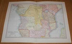
Map of Central Africa - Sheet 55 Disbound from the 1890 'The Library Reference Atlas of the World' covering modern day Gabon, Angola, Democratic Republic of Congo, Uganda, Tanzania, Zambia and Kenya
Published by Macmillan and Co., London, 1890
First Edition
Softcover. Condition: Very Good. Dust Jacket Condition: No Dust Jacket. First Edition. Single disbound coloured map sheet from John Bartholomew's Library Reference Atlas. Suitable for framing. Approx size 35 x 46 cm, vertical centre fold. Map is clean, crisp, clear and bright. Sheet includes: Congo State, Loango, Angola, Cameroons, Matabele Kingdom, Eastern Bamangwato, Mozambique, Imperial British East Africa Company's Territory, Lake Victoria, Lake Tanganika, Lake Nyassa, Damara Land, French Congo Territory, Zanzibar Coast, Mozambique Channel, Bight of Biafra, etc. (Modern day Gabon, Angola, Democratic Republic of Congo, Uganda, Tanzania, Zambia and Kenya). No dust jacket, as published. Quantity Available: 1. Shipped Weight: under 1 kg. Pictures of this item not already displayed here available upon request. Inventory No: 45020124022. For International tracked shipping please select the Priority shipping service.
-
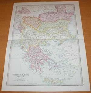
Map of 'Turkey in Europe, Greece, Roumania, Servia &c.' - Sheet 35 disbound from the 1890 'The Library Reference Atlas of the World' covering modern day Greece, Albania, Bulgaria and North Macedonia
Published by Macmillan and Co., London, 1890
First Edition
Softcover. Condition: Very Good. Dust Jacket Condition: No Dust Jacket. First Edition. Single disbound coloured map sheet, from John Bartholomew's Library Reference Atlas. Map covers modern day Greece, Albania, Bulgaria, North Macedonia, Montenegro, Kosovo and parts of Romania, Serbia and Moldova. Suitable for framing. Approx size 46 x 35cm, horizontal centre fold. Map is clean, crisp, clear and bright. Occasional light foxing in margin. Countries/States are shaded in pastel colours and include Roumania, Bulgaria, Servia, Eastern Roumelia, Montenegro, Moldavia, Turkey (in Europe), Greece and Crete or Candia. Parts of Hungary, Bosnia, Asia Minor and Russia around the edges of the sheet are not shaded. No dust jacket, as published. Quantity Available: 1. Shipped Weight: under 1 kg. Pictures of this item not already displayed here available upon request. Inventory No: 45021014015. For International tracked shipping please select the Priority shipping service.
-
Map of 'Northern Asia and Central Asia' - Sheet 44 disbound from the 1890 'The Library Reference Atlas of the World' including modern day Siberia, Kazakhstan, Turkmenistan, Uzbekistan and Mongolia
Published by Macmillan and Co., London, 1890
First Edition
Softcover. Condition: Very Good. Dust Jacket Condition: No Dust Jacket. First Edition. Single disbound coloured map sheet, from John Bartholomew's Library Reference Atlas. Sheet is divided into to map panels showing 'Northern Asia' and 'Central Asia' (Central is at closer scale). Suitable for framing. Approx size 46 x 35cm, horizontal centre fold. Occasional light foxing in margins, map is otherwise clean, crisp and bright. Area covered includes Kara Sea, New Siberia Islands, Maritime Province, Sea of Okhotsk, Sea of Japan, Russian Empire, Siberia, Ural Mountains, Yakutsk, Tomsk, Manchuria, Turkestan, Mongolia, Khiva, Caspain Sea, Aral Sea, Bokhara, and parts of Lapland, Persia, Kashmir, Afghanistan, Japan and China. This includes modern day Kazakhstan, Turkmenistan, Uzbekistan, Kyrgyzstan and Tajikistan. No dust jacket, as published. Quantity Available: 1. Shipped Weight: under 1 kg. Pictures of this item not already displayed here available upon request. Inventory No: 45021014038. For International tracked shipping please select the Priority shipping service.
-
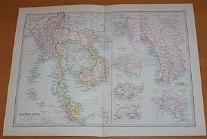
Map of 'Farther India' (Siam, Burma, Anam, Tonquin, etc.) - Sheet 50 disbound from the 1890 'The Library Reference Atlas of the World' covering modern day Thailand, Vietnam, Cambodia, Laos, Malaysia and Myanmar
Published by Macmillan and Co., London, 1890
First Edition
Softcover. Condition: Very Good. Dust Jacket Condition: No Dust Jacket. First Edition. Single disbound coloured map sheet, from John Bartholomew's Library Reference Atlas. Suitable for framing. Approx size 35 x 46cm, vertical centre fold. Map is clean, crisp and bright. Sheet is divided into a main map with 6 smaller map panels. Main map covers 'Farther India' - Siam, Burma, Anam, Tonquin, Cambodia, Tenasserim, Malay Peninsula, Andaman Islands, Nicobar Islands, etc. (covering modern day Thailand, Vietnam, Cambodia, Laos, Malaysia and Myanmar). The other panels are at closer scale and include; Penang, Malacca & Nanning, Singapore, Aden (Yemen), Hong Kong, and Part of Burma (the Irawadi river from Mandalay to mouths). No dust jacket, as published. Quantity Available: 1. Shipped Weight: under 1 kg. Pictures of this item not already displayed here available upon request. Inventory No: 45021014036. For International tracked shipping please select the Priority shipping service.
-
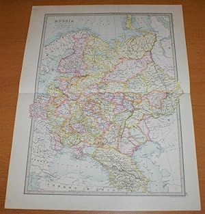
Map of 'Russia in Europe' - Sheet 40 disbound from the 1890 'The Library Reference Atlas of the World' including Finland, Lapland and Poland and modern day Ukraine, Belarus, Latvia, Lithuania, Estonia,Georgia and Azebaijan
Published by Macmillan and Co., London, 1890
First Edition
Softcover. Condition: Very Good. Dust Jacket Condition: No Dust Jacket. First Edition. Single disbound coloured map sheet, from John Bartholomew's Library Reference Atlas. Suitable for framing. Approx size 46 x 35cm, horizontal centre fold. Faint smudges in margin, map is clean, crisp and bright. Sheet covers what was known as 'Russia in Europe' and extends as far east as the Ural Mountains. The mapped area covers what is now Ukraine, Belarus, Latvia, Lithuania, Estonia,Georgia, Azebaijan and part of Russia. Also included are Finland and parts of Norway and Sweden, part of modern Poland, the Black Sea, Constantinople (Istambul), Sea of Azof, Caspian Sea (part), Kara Sea (part), Gulf of Bothnia, Whie Sea, etc. No dust jacket, as published. Quantity Available: 1. Shipped Weight: under 1 kg. Pictures of this item not already displayed here available upon request. Inventory No: 45021014020. For International tracked shipping please select the Priority shipping service.
-
A New System of Modern Geography, Or A View Of The Present State Of The World.Accompanied with an Atlas
Published by Boston: George Clark, 1822, Boston, 1822
First Edition
Full-Leather. Condition: Good. First Edition. Full-Leather. Good. First Edition. 8vo - over 7�" - 9�" tall. Leather frayed at top of spine; cover edges worn; foxing throughout.
-
Historical Atlas of Modern Europe from the decline of the Roman empire, comprising also maps of parts of Asia, Africa, and the New world connected with European history.
Published by Oxford: At the Clarendon Press, 1902
First Edition
Folio(38x30cm) HB 1st edition ex Dudley Reference Library. Unpaginated but insection I to LX. _ bound red cloth boards with crimson leather spine which has gilt lettering-minimal wear & leather is a little scuffed else v.good. No dust jacket. Usual library stamps/labels to endpapers & title page (text unaffected)- _ title page creased, minimal age related discolouring else internally v.good/near fine. (>3kg) Very heavy volume will almost certainly require extra shipping costs.
-
The Imperial Atlas of Modern Geography; an Extensive Series of Maps, including the Most Recent Discoveries and the Latest Political Divisions of Territory in All Parts of the World
Published by Blackie & Son Ltd [1860], Glasgow, 1860
Map First Edition
Green hardback cloth cover. First Edition. 390mm x 330mm (15" x 13"). 100 plates. 100 coloured maps. Heavy book extra shipping needed for overseas. Worn condition. Rebound with new eps. Lacks title page, with only remnants at gutter of several of the preliminary pages. Second half of map 100 missing. Ownership details in pencil on verso of first map. Browning to page edges, with some edge-tears. Sporadic foxing. Occasional damp staining, slightly impinging on content. Sporadic pencil inscriptions. Possible ex-library copy.
-
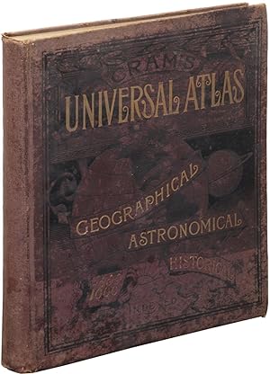
Cram's Universal Atlas Geographical, Astronomical and Historical Containing a Complete Series of Maps of Modern Geography, Exhibiting the World.
Published by Henry S. Stebbins, Chicago, 1888
Seller: Between the Covers-Rare Books, Inc. ABAA, Gloucester City, NJ, U.S.A.
Association Member: ABAA ESA ILAB IOBA
Seller Rating:
First Edition
Hardcover. Condition: Very Good. First edition. Folio. Boards scuffed and stained, spine ends and corners frayed, hinges a bit tender, a solid near very good copy with the maps and plates in fine condition.
-
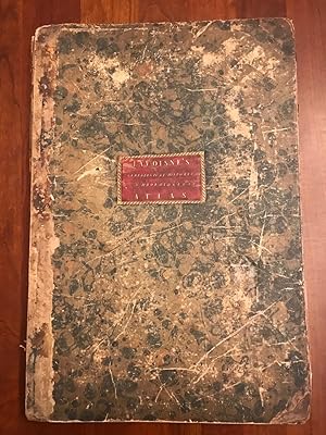
A New Genealogical, Historical, and Chronological Atlas; Being a Complete Guide to History, Both Ancient and Modern, Exhibiting an Accurate Account of the Origin, Descent, and Marriages of all the Royal Families, From the Beginning of the World to the Present Time
Published by J. Barfield, London, 1807
First Edition
A collection of atlas inspired maps that show the genealogical and history of the world, organized in hand-coloured easy to read plates. The first edition of this work. SCARCE. With thirty-five hand-coloured double paged plates. With a key containing an explanation of the marks and abbreviations used in the maps. Collated, bound without plate twenty-two (which appears to binder error). This work is called an atlas, whereas it only drew inspiration from an atlas. It consists of genealogical and chronological tables that document important phases in history, rather than maps. The work is an interesting approach to learning history, laying out the chronology and genealogical of the world in a series of flow diagrams and easy to follow descriptive text. It was intended to provide a more entertaining resource from which children and adults could learn about various aspects of global history. The discussions of the maps include 'Sacred History, from the Creation to the Passover', 'A Map of the Roman Empire, from Julius Caesar to Aurelianus', and 'The History of France, from Pharamond to Pepin'. Compiled by C. V. Lavoisne, who was a Professor at the University of Caen, and C. Gros, who was a Professor at the University of Paris. Lavoisne died before the completion of this work, and so it was continued by Gros. Bound in the original marbled paper boards, both of which are detached. Many of the folio pages are oddly folded. Rather poor condition in its present state, but an excellent candidate for professional repair and rebinding.
-
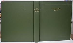
The Imperial Atlas of Modern Geography. An Extensive Series of Maps, Embracing the Most Recent Discoveries and the Latest Political Divisions of Territory in all Parts of the World. Compiled and Engraved from the Most Authentic Sources.
Published by Blackie & Son., London, 1860
First Edition
Hardcover. Condition: Good+. Dust Jacket Condition: No Dust Jacket. First Edition. Modern? (ish) half leather, bound with a heavy plain black unlettered leather spine, with 4 raised bands, and corners over burgundy cloth boards. Reinforced inner hinge in blue 'cloth' with marbled paper endpapers stuck down to white card, and similar to the rear endpapers - which in this case should be 'endcards'. These 'endcards' have the half title and the last page stuck down to these white card endpapers. Possibly an Amateur binder? . Large Folio/Small Elephant Folio. Approx 38 cm x 31 cm (15" x 12.5"). (xi) + [i] + 100 maps plus Index 117 pp. These 100 numbered maps are hand-coloured in outline, mainly on double-page sheets, but some on single page sheets and some are 'North' and 'South' (ie: half a map) on individual double pages. All page fore-edges are gilt. The maps are generally VG but all have uniform and light brown (dust engrained) edges to the blank margins. A lot of this will rub off. Some of the maps have a little light foxing here and there. There is a large tear, repaired with now yellowing sellotape, across Map XXX (30) - A single page map 'The Shores of the Mediterranean, the Adriatic and the Black Sea'. There is a small ink blot to the bottom edge of the 'General Map of Asia'; on the map 'Persia, Afghanistan and Beloochistan' there is an old ink circle around the name 'Jellalabad' and an ink cross in the margin marking this; and some pencil notes on the 'General Map of South America' - easily erased I should imagine. The rest of the Atlas is unmarked. Double page maps measure circa 54 cm x 37 cm. ALL Maps are mounted on raised lengths of paper ensuring there are NO centre staples or similar. Great Source material for researchers /students, and individually lovely pictorial memorials of a world now past - lots of blank uncharted territories worldwide. Great for framing. Very Heavy. See IMAGES. ; Small Elephant Folio 23" tall.
-
A New Atlas Or a Compleat Set of Maps. Representing the different Empires, Kingdoms, States of the known World Including the Modern Discoveries by J. Young, A.M.
First Edition
(Edinburgh and London ?), (1778). Large 4to. (32 x 24,5 cm.). Contemp. hcalf. Raised bands. Title-label with gilt lettering. Top of spine lacks ca. 1 cm. of leather, bottom of spine ca. 1/2 cm. Spine rubbed, wear along hinges. Old owner inscription on top of title-page. Ex Libris Scholae Regis Edinensis. Engraved title-page and 23 double-page (numb. 1-23) and all with original handcolouring. The map of the world (2 hemispheres): printed size 25 x 46 cm. (sheet: 31 x 48,5 cm.). Printed on heavy paper, verso blank, all clean and fine. First edition. Not in Shirley. The copy described by Shirley I, T.YOU - 1 a, having another imprint dated 1782. All the maps in our copy is signed "Published as the Act directs 1st July 1778". Shirley mentions that the Atlas was doubtless intended for educational use.
-
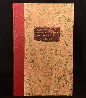
A New Genealogical, Historical, and Chronological Atlas; Being a Complete Guide to History, Both Ancient and Modern, Exhibiting an Accurate Account of the Origin, Descent, and Marriages of all the Royal Families, From the Beginning of the World to the Present Time
Published by J. Barfield, London, 1807
First Edition
Leather. Condition: Very Good. C. V. Lavoisne; C. Gros (illustrator). First edition. A collection of atlas inspired maps that show the genealogical and history of the world, organised in hand-coloured easy to read plates. The first edition of this work. A scarce work. With thirty-five hand-coloured double paged plates. With a key containing an explanation of the marks and abbreviations used in the maps. Collated, bound without plate twenty-two. This work is called an atlas, whereas it only drew inspiration from an atlas. It consists of genealogical and chronological tables that document important phases in history, rather than maps. The work is an interesting approach to learning history, laying out the chronology and genealogical of the world in a series of flow diagrams and easy to follow descriptive text. It was intended to provide a more entertaining resource from which children and adults could learn about various aspects of global history. The discussions of the maps include 'Sacred History, from the Creation to the Passover', 'A Map of the Roman Empire, from Julius Caesar to Aurelianus', and 'The History of France, from Pharamond to Pepin'. Compiled by C. V. Lavoisne, who was a Professor at the University of Caen, and C. Gros, who was a Professor at the University of Paris. Lavoisne died before the completion of this work, and so it was continued by Gros. In a quarter morocco binding with marbled paper to the boards. Externally, smart. Original label to the front board with some loss and rubbing. Internally, firmly bound. Pages are bright and generally clean with the odd mark and handling mark. Plate 25 with some loss to the bottom and fore edge, resulting in loss of some text. Very Good. book.
-
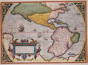
ONE OF THE MOST ICONIC MAPS OF THE WESTERN HEMISPHERE "Americae Sive Novi Orbis, Nova Descriptio", copper engraving published by Abraham Ortelius featured in his "Theatrum Orbis Terrarum", the first modern atlas of the world, from 1570 onwards
Seller: Inter-Antiquariaat Mefferdt & De Jonge, Amsterdam, Netherlands
Seller Rating:
Art / Print / Poster First Edition
ONE OF THE MOST ICONIC MAPS OF THE WESTERN HEMISPHERE "Americae Sive Novi Orbis, Nova Descriptio", copper engraving published by Abraham Ortelius featured in his "Theatrum Orbis Terrarum", the first modern atlas of the world, from 1570 onwards. Here in a second state of first plate with Latin text on verso. Coloured by a later hand. Size: 36,6 x 50,7 cm. Without a doubt one of the most recognized and influential maps of the Americas from the sixteenth century. It formed the European perception of America. When the map was first published, it was the best map of the Americas available. It was in fact the first of it's kind to achieve wide circulation through an atlas. North and South America stretch across this single hemisphere map. To the north, North America somewhat resembles the continent we know today, except the area near Alaska is undefined and the northwest bulges to the east. South America is a squat landmass, early editions have an extension in the southwest that would disappear in later editions of the map. The title is decorated with the key-like geometric decorations common to the maps in Ortelius' atlas. In the ocean, a sea monster lurks. In the Pacific, ships stream through the water, their sails filled with imaginary winds. The Straits of Magellan separate South America from a large southern continent that extends all the way to New Guinea. Tierra del Fuego, named by Ferdinand Magellan because he saw so many small fires burning there, is part of this continent. The name "Novae Guinea", or New Guinea, was coined by Spanish explorer Y�igo Ort�z de Retes in 1545, and it refers to his opinion that the appearance of the native peoples resembled the natives of the Guinea region of Africa. Two place names in the northwest of North America are particularly interesting. Anian derives from Ania, a Chinese province on a large gulf mentioned in Marco Polo's travels . The gulf Polo described was actually the Gulf of Tonkin, but the province's description was transposed from Vietnam to the northwest coast of North America. The first map to do was Giacomo Gastaldi's world map of 1562, followed by Bolognino Zaltieri and Gerard Mercator in 1567. The Strait then became shorthand for a passage to China, i.e. a Northwest Passage. It appeared on maps until the mid-eighteenth century. Quivira refers to the Seven Cities of Gold sought by the Spanish explorer Francisco Vasquez de Coronado in 1541. In 1539, Coronado wandered over what today is Arizona and New Mexico, eventually heading to what is now Kansas to find the supposedly rich city of Quivira. Although he never found the cities or the gold, the name stuck on maps of southwest North America, wandering from east to west. Ortelius' ability to locate and draw upon both Spanish and Portuguese sources is apparent throughout the map, and is quite remarkable, given the manner in which each nation guarded its cartographic information. Both nations kept their geographic knowledge locked in a single institution, with all cartographic knowledge maintained on a single master map. Copies of the master map were closely monitored and pilots could be punished for not returning their charts; however, no vault is impenetrable and geographic secrets leaked out, including to Ortelius in Antwerp. The influence of this and other Ortelius maps stems from the popularity and dominance of his atlas in the European market. In 1570, Ortelius published the first modern atlas; that is, a set of uniform maps with supporting text gathered in book form. Previously, there were other bound map collections, specifically, the Italian Lafreri atlases, but these were sets of maps-not necessarily uniform-selected and bound together on demand. Theatrum Orbis Terrarum, Ortelius' atlas, outperformed competing atlases from other cartographic luminaries like the Mercator family. Between 1570 and 1612, 31 editions of the atlas were published in seven languages. This map, in its first edition,appeared in the very first 1570 atlas. Price: Euro 4.500,-.