New Correct Map Germany (9 results)
 More images
Language: English
Published by John & Paul Knapton, London 1744
- Map
Seller: Tas Alco Books & Maps, Coburg North, VIC, AustraliaTas Alco Books & Maps
Contact seller5-star sellerCondition: Used - Fine
US$ 126.97
US$ 30.83 shippingShips from Australia to U.S.A.Quantity: 1 available
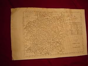
Condition: Fine. For sale an original antique map of South West Germany - "A New and Correct Map of the South West part of Germany Containing the Archbishopricks and Electorates of Mentz and Triers: also that of the Palatinate of the Rhine; the Duchy of Wurtemberg; Franconia, Swabia, Alsace, Lorrain &c." Engraved by Richard Wi…lliam Seale and from "The History of England", by Paul de Rapin-Thoyras, translated by Nicolas Tindal, published by John & Paul Knapton. London, 1744. Drawn by Emmanuel Bowen, showing the amazing detail he was well known for. Map is from half way thru the Austrian War of Succession, so the political borders shown will change in coming years, making this map even rarer. Especially with the level of detail the cartographer has drawn. Size: The map measures approx 540mm x 410mm, printed on good quality thick paper, with 2 folds. Also selling the adjoining South-West Germany map. Also selling the adjoining North-West Germany map. Condition: NM - no damage. ###I can certify this is an Original Antique Map - NOT a reproduction!### Postage across Australia with tracking & in a cardboard postal tube. Or Personal Pickup from Coburg North, Victoria, Australia. Overseas please message first as Ebay postage not that reliable. Richard William Seale (illustrator).

Published by London 1790
Seller: Luis Porretta Fine Arts, Nanaimo RPO Country Club, BC, CanadaLuis Porretta Fine Arts
Contact seller4-star sellerCondition: Used - Very good
US$ 53.14
US$ 28.00 shippingShips from Canada to U.S.A.Quantity: 1 available
Condition: Very Good. No Dust Jacket. This map is in VG condition, trimmed closely at top edge, plate marks defined, 12" x 14", uncolored as published. This map details a large swathe of Europe including Switzerland, France, Prussia and Hungry. Images available. ; 8vo.
 More images
Published by Germania
Seller: Sergio Trippini, Gavirate, VA, ItalySergio Trippini
Contact seller4-star sellerCondition: Used
US$ 59.60
US$ 55.55 shippingShips from Italy to U.S.A.Quantity: 1 available
Incisione inserita nell'opera "A New, Royal, Authentic and Complete System of Universal Geography, Ancient and Modern: Including All the Late Important Discoveries Made by the English, and Other Celebrated Navigators . History and Description of the Whole World. Likewise the Essence of the Voyages of the Most Enterprising Naviga…tors." edita a Londra da J. Cooke nel gennaio del 1787.
Language: German
Published by London ca. 1750. 1750
Seller: Antiquariat Olaf Drescher, Nuthe-Urstromtal OT Nettgendorf, , GermanyAntiquariat Olaf Drescher
Contact seller5-star sellerCondition: Used
US$ 52.45
US$ 16.14 shippingShips from Germany to U.S.A.Quantity: 1 available
1 Bl. Die Karte umfasst das Gebiet von Arhus im Nordwesten über Wilna im Nordosten, Efzek im Südosten bis Geneva im Südwesten. - Zustand: Dezent randfleckig u. mit leichten Knickspuren, kl. Randeinriss rechte untere Ecke (3 cm), sonst sehr gut. Sprache: Deutsch Gewicht in Gramm: 100 22 x 35,5 cm, in Klarsichtflolie eingeschlagen…es Blatt.
 More images
Published by Germania
Seller: Sergio Trippini, Gavirate, VA, ItalySergio Trippini
Contact seller4-star sellerCondition: Used
US$ 95.36
US$ 55.55 shippingShips from Italy to U.S.A.Quantity: 1 available

Published by London: [c.1750] 1750
Seller: Peter Harrington. ABA/ ILAB., London, United KingdomPeter Harrington. ABA/ ILAB.
Contact seller5-star sellerCondition: Used
US$ 131.18
US$ 29.49 shippingShips from United Kingdom to U.S.A.Quantity: 1 available
A map of Germany with an inset showing the distance between towns and the English miles. Copper engraving. Hand coloured. Size: 241 x 390 mm Good condition.
Published by [London]: 18th Century European Publisher, [1700s]. 1700
- Manuscript
Seller: Wittenborn Art Books, San Francisco, CA, U.S.A.Wittenborn Art Books
Contact seller5-star sellerCondition: Used - Good
US$ 150.00
US$ 10.00 shippingShips within U.S.A.Quantity: 1 available
Condition: Good. 20 x 16 inches. Very Good. Minor loss from pinholes in top right corner. Fine copperplate engraving. 18th Century, uncolored, folded map of Germany. Scarce.
Published by London, Osborne et al., 1766. 1766
Seller: Antiquariat am Moritzberg, Hildesheim, NDS, GermanyAntiquariat am Moritzberg
Contact seller1-star sellerCondition: Used
US$ 178.81
US$ 11.57 shippingShips from Germany to U.S.A.Quantity: 1 available
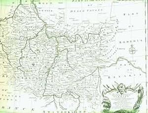
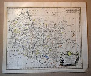
Teilkolorierte OKuperstichkarte mit Kartusche. 35 x 43 cm (Druckspiegel). 2 Knickfalten; Blatt gering angegraut. Die Abbildung reicht von Zürich bis Düsseldorf, von Straubing bis Clermont. EN.

Published by Osborne et al., London. 1735
Seller: Buecherstube Eilert, Versandantiquariat, Dresden, DD, GermanyBuecherstube Eilert, Versandantiquariat
Contact seller5-star sellerCondition: Used
US$ 226.49
US$ 55.55 shippingShips from Germany to U.S.A.Quantity: 1 available
34,5 x 42 cm. Kolorierter Kupferstich. Rechts unten kol. Titelkartusche. Unter Passepartout. Guter Zustand. Die Abbildung reicht von Zürich bis Düsseldorf, von Straubing bis Clermont. OO, 25, Krippe Sprache: en.


