
Order Total (1 Item Items):
Shipping Destination:

North Devon Scale Miles Inch (6 results)
Skip to main search results
Search filters
Product Type
- All Product Types
- Books (3)
- Magazines & Periodicals (No further results match this refinement)
- Comics (No further results match this refinement)
- Sheet Music (No further results match this refinement)
- Art, Prints & Posters (No further results match this refinement)
- Photographs (No further results match this refinement)
- Maps (3)
- Manuscripts & Paper Collectibles (No further results match this refinement)
Condition Learn more
- New (No further results match this refinement)
- As New, Fine or Near Fine (No further results match this refinement)
- Very Good or Good (3)
- Fair or Poor (3)
- As Described (No further results match this refinement)
Binding
- All Bindings
- Hardcover (No further results match this refinement)
- Softcover (5)
Collectible Attributes
- First Edition (1)
- Signed (No further results match this refinement)
- Dust Jacket (1)
- Seller-Supplied Images (4)
- Not Print on Demand (6)
Language (2)
Price
- Any Price
- Under US$ 25
- US$ 25 to US$ 50
- Over US$ 50 (No further results match this refinement)
Free Shipping
Seller Location
Seller Rating
-

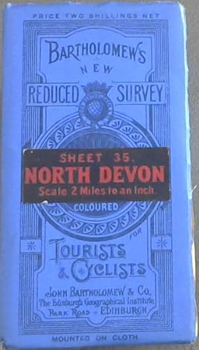
Bartholomew's New Reduced Survey for Tourists and Cyclists Sheet 35 North Devon Scale 2 miles to an inch Coloured
Published by Edinburgh: Bartholomew
Paperback. Condition: Fair. Fair FOLD-OUT MAP. No date given. Looks to be around 1914-1920. One of "The Pocket Series of Touring Maps." Blue flexible wrappers Cloth-backed map. No marking. Creases are quite defined with some folds showing through. Cover shows edge wear with rubbing/creases. Still very readable.; 100% Satisfaction Guaranteed! Ships same or next business day!
-

W H Smith & Son's Reduced Ordnance Survey Map of North Devon. Scale 4 miles to an Inch
Language: English
Published by W H Smith & Sons
Map
Map. Condition: Fair. Folded map mounted on cloth, front of map has been covered with self-adhesive clear plastic; cloth on rear is foxed and stained, some stains show through but not too obtrusively; cloth covered card cover is rubbed and worn, quite marked, and is partially covered with the adhesive plastic. Map covers a district of 72x50 miles, SW corner at Peverell's Cross/st Bellarmins Tor, NW corner Lundy, NE corner just inland from Berrow, SE corner Rousdon (between Axmouth and Lyme Regis), and just north of Torquay. Undated, but late C19?
-
North Devon: "Geographia" Large Scale Road Map. 2 miles: 1 inch.
Published by Geographia, London, 1965
Seller: Victoria Bookshop, BERE ALSTON, DEVON, United Kingdom
Seller rating 4 out of 5 stars

First Edition
Paperback. Condition: Good. First Edition. undated orange wrappers. Book.
-

Bartholomew's New Reduced Survey. Sheet 35. North Devon Scale 2 miles to one inch. Coloured for Tourists and Cyclists
Language: English
Published by John Bartholomew & Co, Edinburgh
Seller: Joy Norfolk, Deez Books, IPSWICH, United Kingdom
Seller rating 5 out of 5 stars

Map
Map. Condition: Fair. Dust Jacket Condition: No Jacket (as published). A coloured map on paper depicting the English county of Devon, not dated but thought to be from the first quarter of the 20th century. Some wear to the edges of the brown folded cover which has lost part of the stick on label, but the map is on paper and in one piece but some of the folds are failing. All orders processed and shipped promptly from the UK.
-

Soft cover. Condition: Very Good. Dust Jacket Condition: Very Good. # AS PICTURED # Canvas map. Some minor wear and toning, commensurate with age, but predominantly neat and tidy, the map particularly bright and clean.
-
Bartholomew's New Reduced Survey : Sheet 35 North Devon - Scale 2 miles to an Inch - for Tourists and Cyclists
Published by John Bartholomew & Co. / The Edinburgh Geographical Institute, Edinburgh, 1914
Softcover. Condition: Good. No Jacket. Folded map for North Devon as part of an early series from John Bartholomew. The linen-card covers have mild wear. Otherwise they have much character and charm. The map itself is mounted on linen-cloth. The reverse of the map has some age-mottling. The face of the map is fresh, clean, clear, assured, more than competent. fk. Our orders are shipped using tracked courier delivery services.
