
Philips New Map Gold Fields (3 results)
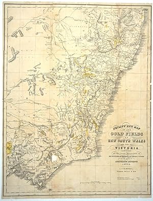
Published by George Philip & Son, Liverpool 1853
- Hardcover
- First Edition
Seller: Antipodean Books, Maps & Prints, ABAA, Garrison, NY, U.S.A.Antipodean Books, Maps & Prints, ABAA
Contact seller4-star sellerCondition: Used - Good
US$ 825.00
US$ 10.00 shippingShips within U.S.A.Quantity: 1 available
Maps. Condition: Good condition. Lithographed linen backed map of southeastern Australia and its gold fields. Philip seems to have issued this map with this title in 1852 and 1853. There are 3 copies recorded on Trove. However, there are variations which include the absence or presence of the following points- "Engraved by J. Ge…llatly, Edinr."; "Gold Districts Coloured. Yellow / Australian Agricultural Cos. Land. Red" below the title; a decorative border which encompasses the lat. & longitude 145 to 153 in circles or a plain ruled border which includes the long. numbers simply above the rule line. Our copy is unrecorded in that it includes the notation about Australian Agricultural Land (the red not apparent on map, while the yellow for the gold districts is vivid) and has a simple ruled border that includes long. 145-153. Lib Aus ID 44599038 / FL3781185 is visually the most similar to our copy with these differences: the library copy includes the Engraver Gellatly (ours does not); lacks the note about "Goldfields coloured" and lacks the long. number "153" at the bottom margin. The title "Victoria Part of Australia Felix" is printed in the state which was created a couple of years earlier, in 1851. Recently discovered gold finds are shown highlighted in yellow. Map of area from the Clarence River in the north, to west of Port Phillip in the South. Recently discovered gold finds are highlighted in yellow. Most of the gold fields are shown situated in NSW as they were the earliest discovered - Bathurst, Turon River, Ophir, Summerhill. Also marked is Tamworth, Goulbourn, Quenbeyan and Araluen. Interestingly, Lake George is mapped but denoted as "dry". In Victoria, there are many more gold fields than the 1852 first edition. Fields include: Mt. Buninyoung (with road from Geelong), Mt. Alexander, the Plenty Ranges, the Yarra Yarra River, Mt. Gibbo, the May Day Hills, Mt. Tambo, and Mt. Wellington. George Philip was born in Aberdeenshire in 1799. He started business in 1834 working first in Liverpool, his son joined him in 1848 and they then moved to London in 1856, where they issued maps up until the 1890s. It is very unusual to find separately published Australian maps- they tend to be practical guides to gold seekers and issued without the protection of boards, and were usually destroyed with use. Important early map of the Australian discoveries. There is however a small defect east of the Australian Alps, a small rectangular section, roughly 1/2" square below the "o" in Victoria; there is some marginal chipping that has been restored as well. See illustration. Archivally backed in linen, 18 5/8 x 24". Three copies held in Australia include: Libraries Australia ID 44599405 & Bib ID 3552844- Dated 1853 in the title; no "Note" regarding gold below the title; decorative border that includes Lat. (153) in the lower margin; no reference to George Philip & Son below the rule line. The copy at the SLNSW (FL3780907) has the note below "George Philip & Son- "Note: Goldfields coloured yellow". The third copy, Libraries Australia ID 44599038, includes the Engraver Gellatly (ours does not); lacks the note about "Goldfields coloured" and lacks the long. number "153" at the bottom margin.

- Map
Seller: Geographicus Rare Antique Maps, Brooklyn, NY, U.S.A.Geographicus Rare Antique Maps
Contact seller4-star sellerGood. Right and left margin extended. Backed on archival tissue. Some wear on original fold lines. Size 24.25 x 19.5 Inches. A remarkable and very rare 1853 map of the gold discoveries in South Australia and Victoria. The map covers from Coffin Bay to Cape Ottoway and as far north as Mount Hopeless. Major gold discoveries are hi…ghlighted in yellow, and these include discoveries near Adelaide on the Onkaparinga River and in Victoria along the Loddon River, near Mt. Freeth, Daisy Hill, on Creswell Creek, Mt. Boninyon, and Ballarat. Other mines, such as the Burra Burra copper mines are also identified. In addition, the map shows early railroad development between Port Adelaide and Adelaide. This map accompanied John Capper's 1853 Emigrant's Guide to Australia . Although extremely rare today, the Capper Emigrant's Guide was popular in its day, going through at least three editions between 1853 and 1856. References: OCLC 225069043.

Published by George Philip & Son,, Liverpool, 1852
- Map
Seller: Daniel Crouch Rare Books Ltd, London, , United KingdomDaniel Crouch Rare Books Ltd
Contact seller4-star sellerCondition: Used
US$ 1,359.74
US$ 26.40 shippingShips from United Kingdom to U.S.A.Quantity: 1 available
The New South Wales first gold rush Engraved folding map with some colouring, included within pamphlet. The map covers the whole area of New South Wales in Australia, highlighting in yellow the locations of gold fields. The first Australian Gold Rush began in May of 1851 when prospector Edward Hargraves found substantial deposit…s in Bathurst in New South Wales. Hargraves was offered a reward by both the Colonies of New South Wales and Victoria. News soon spread and by the end of 1851 numerous other gold fields were beginning to be exploited in both New South Wales and Victoria. The rush would continue on and off for the rest of the nineteenth century, and have a great effect on the population, which increased from 430,000 in 1851 to 1.7 million in 1871. The map is housed within a guide of Australia in Welsh, 'Country of Gold or the Companion of the Welsh migrant to Australia'. The region was named by Captain James Cook after its resemblance to South Wales, and Welsh people numbered amongst the first settlers. In the nineteenth century mass emigration from Wales began, first with farmers and later with gold diggers and coal miners.


