Plan City Augsburg (4 results)

Published by Meyers Konversations
- Art Print
Seller: Artisans-lane Maps & Prints, Sidney, BC, CanadaArtisans-lane Maps & Prints
Contact seller4-star sellerCondition: Used - Very good
US$ 18.40
US$ 19.00 shippingShips from Canada to U.S.A.Quantity: 1 available
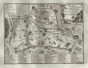
no binding. Condition: very good. The historical map from 1894 shows the local topography and transportation routes in the city of Augsburg, located in south-central Germany. Augsburg is the capital of the Swabia administrative region of Bavaria and is situated at the confluence of the Wertach and Lech rivers. The map shows the…city's layout, including its streets, buildings, and railway lines. The 1890s wood engraving is an antique map that provides a glimpse into the history and development of Augsburg. The city has a rich cultural heritage and is known for its Renaissance architecture, including the Augsburg Town Hall and the Fuggerei, the world's oldest social housing complex. Augsburg is also an important economic center and is home to several major companies, including MAN SE and KUKA Robotics. The city is well-connected by road, rail, and air, making it an accessible destination for both business and leisure travelers. The map is a valuable resource for anyone interested in the history and development of Augsburg and the surrounding region. Approximate Overall Size: 6 X 9 1/2 inches CONDITION: Book Plate Map - Excellent Condition. Folded. German Text. Beautiful with excellent detail. Map Print is Blank on Reverse Side.

Published by J. Stockdale 1800
- Map
Seller: Antiquariaat Dat Narrenschip, Middelburg, NetherlandsAntiquariaat Dat Narrenschip
Contact seller5-star sellerCondition: Used - Fine
US$ 119.58
US$ 31.35 shippingShips from Netherlands to U.S.A.Quantity: 1 available
No Binding. Condition: Fine. Antique city map of Augsburg. Title cartouche top right; legend at the top left and bottom of the map. Backside blank. Hand-coloured copper engraving, published in 1800 by J. Stockdale, Piccadilly, in 'A geographical, historical and political description of the empire of Germany, Holland, (.).' Dimen…sions (image): 17 x 22 cm.
 More images
- Art Print
Seller: Hammelburger Antiquariat, Hammelburg, , GermanyHammelburger Antiquariat
Contact seller5-star sellerCondition: Used - Very good
US$ 2,140.54
US$ 34.83 shippingShips from Germany to U.S.A.Quantity: 1 available
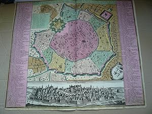
Kein Einband. Condition: Gut. Milano, anno 1740, Plan and panorama, Seutter M., old colours Milan. SEUTTER, M. [Augsburg, 1740] "Milano, la Citta principale et Fortezza Reale del Ducato medesimo in Italia." Size of the leaf: 50x58 cm. Boldly engraved and colored plan of Milan, combined with a very attractive panorama of the city…. The plan shows the modernized fortifications of the Castello Sforzesco, whose bastions and plazas are named. An image of the Duomo is on the plan; it is one of 249 of the city's churches and monasteries numbered and named in tables to the left and right of the map. The plan is embellished with the arms of the House of Sforza and the Duchy of Milan. Below the plan is a panoramic view of the inner part of the city, dominated by the Castello. Little brownish on margins, printed on thick paper.
Language: German
- First Edition
- Art Print
Seller: Antiquariat Clemens Paulusch GmbH, Berlin, , GermanyAntiquariat Clemens Paulusch GmbH
Contact seller5-star sellerCondition: Used
US$ 239.17
US$ 31.23 shippingShips from Germany to U.S.A.Quantity: 1 available
Kupferstich v. J. Andrews, 1771, 16,3 x 21,3 Erkärungen des detailreichen Plans oben links und unterhalb mit 87 Positionen (englisch). Erste Ausgabe des Plans mit röm. Nummerierung oben rechts aus Andrews, John: "A Collection of Plans of the Capital Cities of Europe, and Some Remarkable Cities in Asia, Africa and America." Tadel…los.


